Click on an element below to expand that portion of the web page
Currently there is no Airport Weather Warning in effect for the Albuquerque International Sunport
| Infrared | Visible | GeoColor |
|---|---|---|
 |
 |
 |
|
Infrared - This image is taken in the infrared band of light and show relative warmth of objects. Colder objects are brighter and warmer objects are darker. Lower layers of clouds, generally warmer and lower in altitude, are colored gray. Colder and generally higher clouds tops are highlighted in colors. Infrared imagery is useful for determining cloud features both at day and night. |
Visible - This image is taken in visible light, or how the human eye would see from the satellite. Sunrise and sunset can be tracked in this image. However, once the sun sets, visible imagery is no longer useful. |
GeoColor - is a multispectral product composed of True Color (using a simulated green component) during daytime, and an Infrared product that uses bands 7 and 13 at night. During the day, the imagery looks approximately as it would when viewed with human eyes from space. At night, the blue colors represent liquid water clouds such as fog and low stratus, while gray to white indicate higher ice clouds, and the city lights can also be seen. |
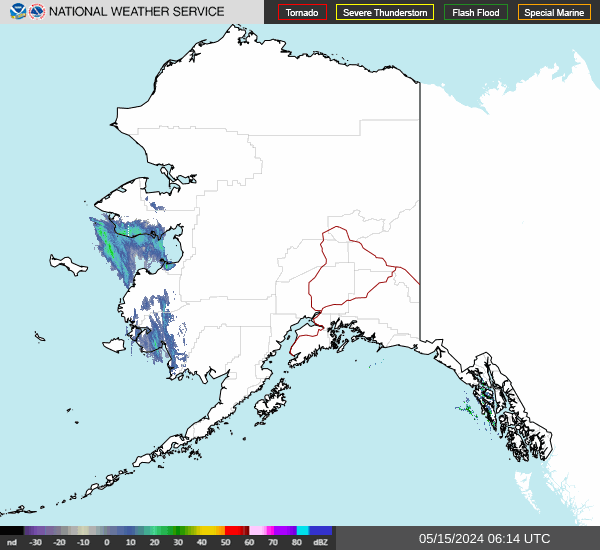
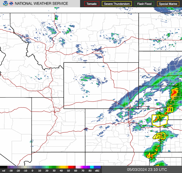
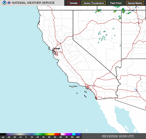
| Regional Radar Mosaic Sectors Loops (click image) |
 |
 |
 |
 |
 |
 |
 |
 |
 |
 |
 |
 |
| Farmington (KFMN) | Gallup (KGUP) | Santa Fe (KSAF) | Las Vegas (KLVS) | Tucumcari (KTCC) | Cannon AFB (KCVS) | Roswell (KROW) |
Latest Upper Air Sounding from Albuquerque (Weather Balloon Data issued twice daily) |
Forecast Soundings for Albuquerque (Model Projections)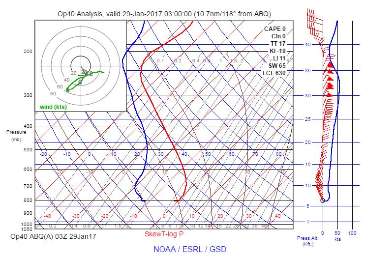 |
Albuquerque (KABX) Radar Velocity Azimuth Display Wind Profile (Observed) |
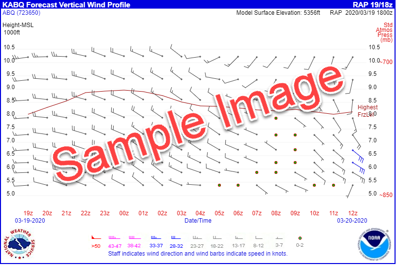
Albuquerque Vertical Wind Profile (Forecast from Rapid Refresh Model)Lowest 2000 ft Above Ground Level Vertical Wind Profile (for lowest 2000 ft) |
Albuquerque Vertical Wind Profiler at Double Eagle Airport (Real-time observations)Note: The Wind Profiler is moved to Balloon Fiesta Park during Balloon Fiesta Double Eagle (Albuquerque) Vertical Wind Profiler |
|
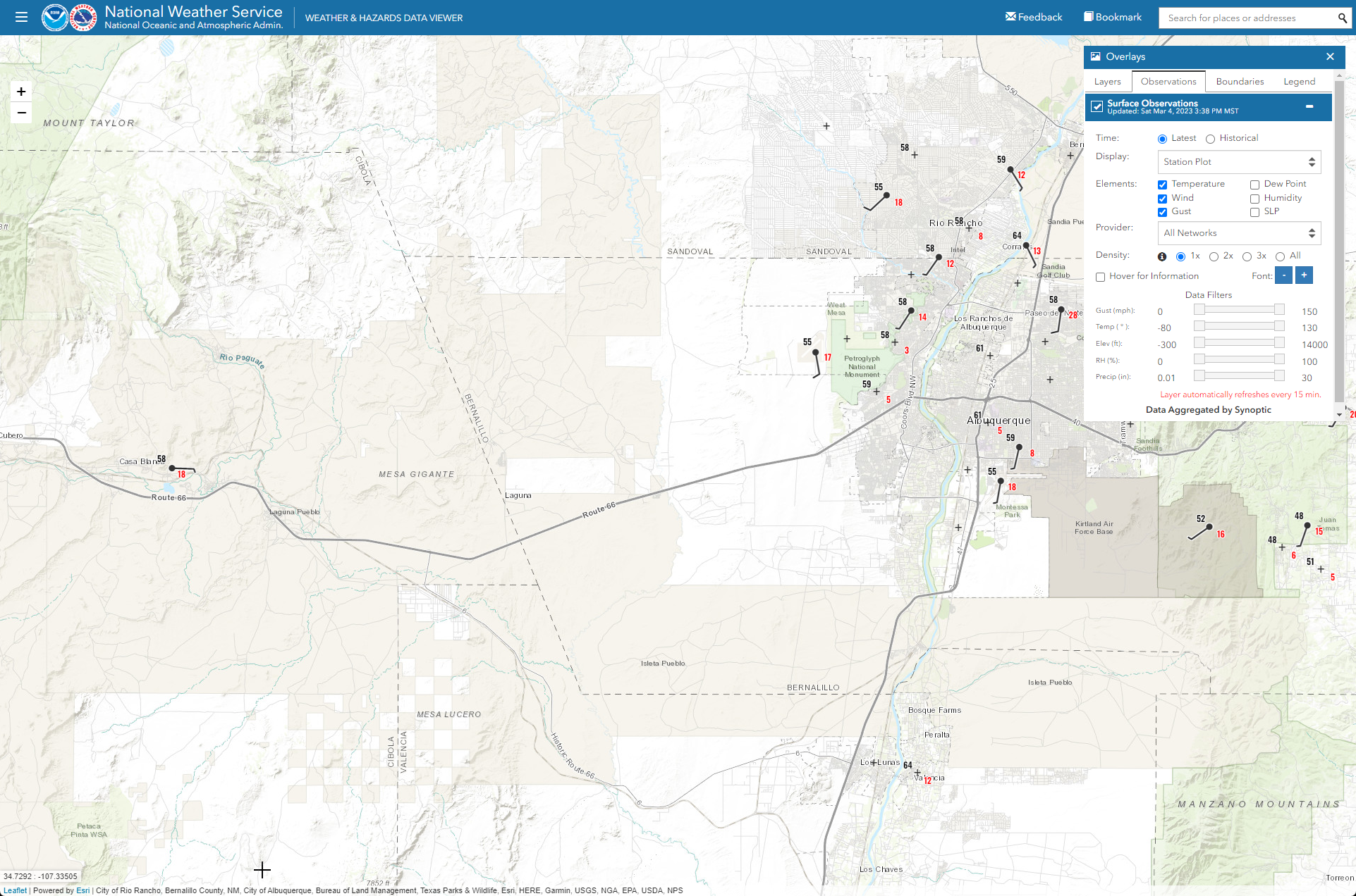 Map of Surface Observations (Including Winds) Once the map is loaded, click on an observation site for more details. |
|
Albuquerque (KABX) Radar Velocity Azimuth Display Wind Profile (Observed) |
Albuquerque Vertical Wind Profile (Forecast from Rapid Refresh Model)Lowest 2000 ft Above Ground LevelVertical Wind Profile (for lowest 2000 ft) |
Albuquerque Vertical Wind Profiler at Double Eagle Airport (Real-time observations)Note: The Wind Profiler is moved to Balloon Fiesta Park during Balloon FiestaDouble Eagle (Albuquerque) Vertical Wind Profiler |
|
Map of Surface Observations (Including Winds) Once the map is loaded, click on an observation site for more details. |
|
Phone Numbers for Up-to-the-Minute Airport Observations |
|---|
|
This is a nationwide information resource from NOAA
Highly acclaimed starting point for comprehensive self-briefing forecasts/data
AIRMETs, SIGMETs, TURBC, ICG, PIREPs, flight-level winds, CCFP/CAWS and more
Regional perspective of aviation weather forecasts and data
Free 7-day forecasts, warnings, radar, satellite, forecast discussion, forecast graphics and more
Issued for winds greater than or equal to 35 kt; 1 inch snow accumulation; frequent lightning around the airport; freezing rain; or large hail (3/4" diameter or greater).
Diagram showing the relative frequency of wind direction and speed each airport


 Follow us on YouTube