 |
|
 |
|
|
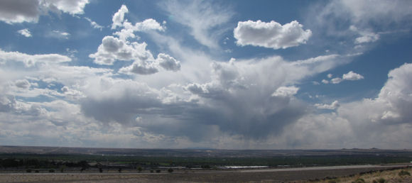
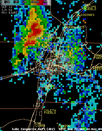
Thunderstorms can be considered dry if they don’t produce any rain at the surface. However, for the fire weather community, a "dry thunderstorm" may be used to describe a storm producing very little rainfall, such that is not effective in checking fire spread after lightning ignition. The second scenario is more common, though there are rare instances when thunderstorms produce no sensible rainfall. In the purest sense, “dry” thunderstorms produce rain just below the cloud base but due to a very dry atmosphere below the cloud base, the rain evaporates at some point between the cloud base and the ground. Meteorologically speaking, this is called virga. In the fire fighting world, “dry” thunderstorms produce measurable precipitation but due to varying fuel types measurable rain (.01”) is not sufficient to moisten the fuel bed effectively. In order to moisten all layers of vegetation, rainfall amounts need to penetrate the aerial canopy (or the highest vegetation layer) and reach the surface. This is referred to as a "wetting rain". For fire weather considerations, dry versus wet thunderstorms is a rolling scale, dependent on the type of surface fuel bed and antecedent weather conditions. If it has been hot and dry for a long period, rainfall amounts need to be larger in order to moisten the fuel bed and lessen the chances of lightning fire ignition. If the surface fuel bed lies below a closed forest canopy, more rainfall is required to penetrate the canopy and reach the surface fuel. For example, in most closed canopy forests of New Mexico, rainfall less than a tenth of an inch defines a “dry” thunderstorm. Within grassland areas where a forest canopy is not present, lesser rainfall is needed from a thunderstorm in order for it to produce wetting rain. A “dry” thunderstorm could ruin a picnic, but could ignite many wildfires as well. Fire weather meteorologists also use the phrase “mixture of wet and dry” to describe thunderstorms which produce a diverse rainfall pattern. This means that the main rain shaft accompanying the thunderstorm produces wetting rain but the footprint of this wetting rain is small, while much lighter amounts are found around the periphery of the cell. Lightning can strike outside of the wetting rain footprint. On May 24th, 2009 one such thunderstorm cell affected the greater Albuquerque metro area between 5 to 6 pm. The cell formed to the west of Rio Rancho and progressed southeastward across Corrales and the far Northeast Heights of Albuquerque.
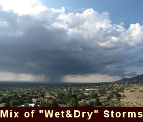
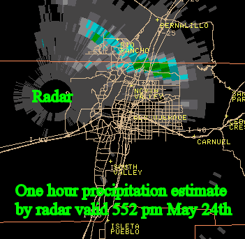
City Net observers and Albuquerque area observation sites measured 0.25 to 0.45 inches of rainfall within the main rain shaft. Pea sized hail was also reported with this storm. Rain amounts outside of the main rain core were less than a tenth of an inch. Typically in New Mexico, when a person cannot see through a rain shaft high precipitation totals generally result. This is especially true when surface humidity is greater than 30% and the main rain shaft is persistent. Under these situations a quarter to three quarters of an inch of rain can fall in a half hour. Photos taken during the event show a rainshaft completely obscuring the horizon. |
|
 |
 |
|
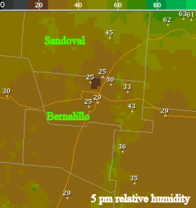
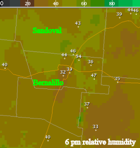
Rain can also be observed falling outside of the main rain shaft. This represents the “drier” area of the storm cell. Relative humidity values also rose between 5 pm (left panel below) and 6 pm (right panel below). Note that in the northern Albuquerque Metro area, relative humidities increased from 25-30 percent to 45-55 percent in one hour. |
|
 |
 |
|
It is not known whether a fire was started from this particular cell but under the right fuel conditions a fire could have resulted because lightning occurred outside of the wetting rain footprint. Other factors that affect fire ignitions due to thunderstorms include storm motion, the duration of any rainfall which occurs and antecedent conditions immediately following the passing thunderstorm. Storms that possess a large wetting rain footprint but move quickly (20 to 30 mph) can still start fires, in part because rainfall duration in any one location can be very brief and moisture may not effectively penetrate the surface soil or fuel bed. Storms are generally more effective at igniting fires if atmospheric conditions immediately following the cell passage become drier and breezier and the fuel bed is especially dry preceding the storm.
“Dry” thunderstorms are most common in New Mexico during May and June, and are most likely to start fires during the month of June. However, if the preceding winter was dry then followed by very little rainfall during the early spring period, the period mid-April through May is also susceptible to dry thunderstorm effects, particularly fire ignitions. A few episodes of “dry” thunderstorms can also affect the fall period. |
|


 Follow us on YouTube