| 2017 Weather Highlights | Hydrology/Drought Status | Fire Weather | Records and Extremes | Monthly Highlights | Severe Weather |

.png)

|
Review of Severe Weather Across New Mexico in 2017
|
|
|
|||||||||||||||||||||||||
|
|
|||||||||||||||||||||||||
|
Severe weather is defined as hail greater than or equal to 1 inch, thunderstorm wind gusts greater than or equal to 58 mph, a flash flood or a tornado. However, prior to January 5, 2010, the criteria for severe hail was 3/4 inch. For consistency, the table below, as well as the map above, includes all severe weather reports, including hail reports as small as 3/4 inch. This year, the National Weather Service in Albuquerque received 335 severe weather reports. The total number of severe weather reports across the state as a whole was 420. These totals do not include wind gusts greater than or equal to 58 mph that occurred from non-thunderstorm wind events. The table below shows the breakdown of reports received.
It should be noted, however, that winds less than 58 mph can blow over high profile vehicles, toss trampolines and cause tree damage to unhealthy trees.
|
|||||||||||||||||||||||||
|
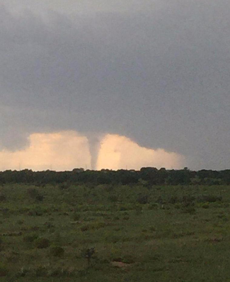
There were far more severe weather reports this year than in 2016. In 2016, there was a total of 222 reports across the state, close to half of this years total. The number of severe thunderstorm warning issued this year from the National Weather Service in Albuquerque totaled 501. Only one other National Weather Service office in the country issued more severe thunderstorm warnings this year! That office would be NWS Norman, Oklahoma who issued 923! Here are the top severe weather events that occurred in New Mexico in chronological order. May 8th: We'll call this round one. Severe thunderstorms erupted across eastern New Mexico on the afternoon of May 8th shortly after 3 pm. These storms merged into two areas of concern. First, stretching from near Fort Sumner northward into Harding County. This area of storms produced ping pong ball size hail in Fort Sumner and the first tornado of the year near Roy. The second area of thunderstorms were located across Chaves County, and went on to produce golf ball size hail on the west side of Roswell in the evening.
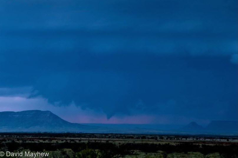
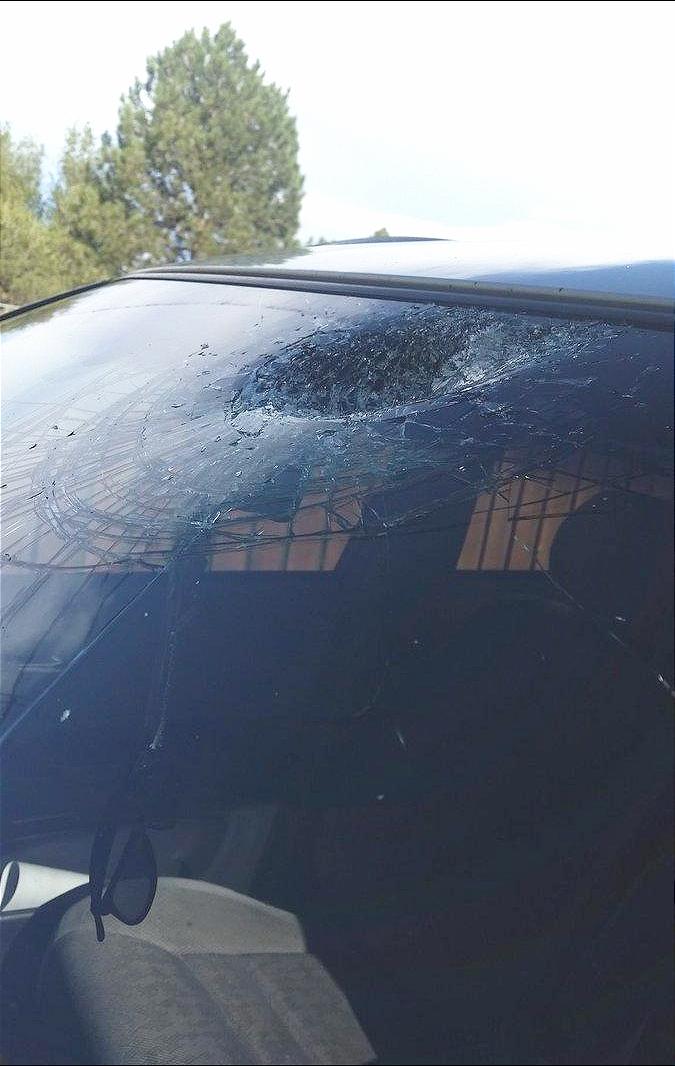
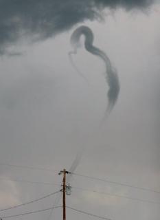
This funnel cloud photo was snapped by David Mayhew on May 8th. The funnel was located southwest of Quay and moved north-northeast toward the I-40 corridor. May 9th: As it turned out, the atmosphere was just getting started on May 8th. On May 9th, widespread severe weather, including hail and multiple tornadoes, developed across central and eastern New Mexico. A potent upper level low pressure system was moving slowly east across the Desert Southwest as low level moisture was drawn into central and eastern New Mexico. Storms initially developed shortly after midnight from Santa Fe to Farmington, and produced quarter size hail and strong winds. Then, after sunrise, another round of showers and thunderstorms developed over central New Mexico and shifted eastward through early afternoon. Some storms were severe and several funnel clouds and large hail were reported around the Estancia Valley. Additionally, a brief tornado developed near the Santa Fe Airport shortly after noon and a significant hailstorm struck the Interstate 25 corridor near Kewa Pueblo. Though the tornado did minor damage, the hail storm resulted in significant damage to homes and vehicles. Yet another wave of storms developed over central New Mexico during the afternoon and produced tornadoes near Carrizozo, Clines Corners, and Wagon Mound. Large hail up to the size of golf balls was also reported with these storms. Farther west, nickel to quarter size hail was reported from Rio Rancho north into the Jemez Mountains. Severe thunderstorms continued to pound eastern New Mexico well into the evening hours with golf ball to hen egg size hail producing damage in areas around Roswell and Tucumcari. All-in-all, 71 severe thunderstorm and 15 tornado warnings were issued on May 9th. This was the busiest one day period for NWS Albuquerque. 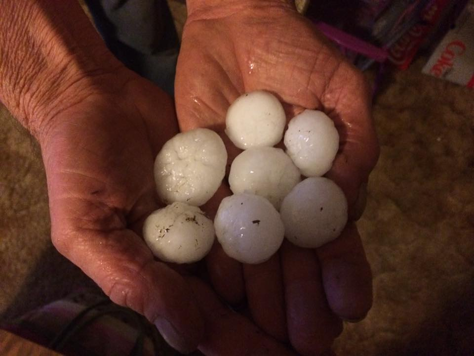 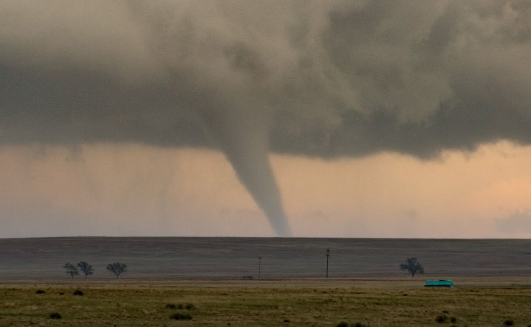
Left: Large Hail collected in Roswell. Photo courtesy of Lisa Butler Bowers. Right: Tornado near Wagon Mound. Photo courtesy of Tom Stef. May 22nd: Showers and thunderstorms erupted along the central mountain chain and tracked southeastward across the Pecos River Valley during the afternoon and the evening of May 22nd. The strongest storms were across De Baca and Chaves counties where at least two separate supercells dropped greater than golf ball size hail across the region. After storm chasers in the area side-stepped the large hail, they witnessed an incredible sunset as the storms departed and weakened to the east.
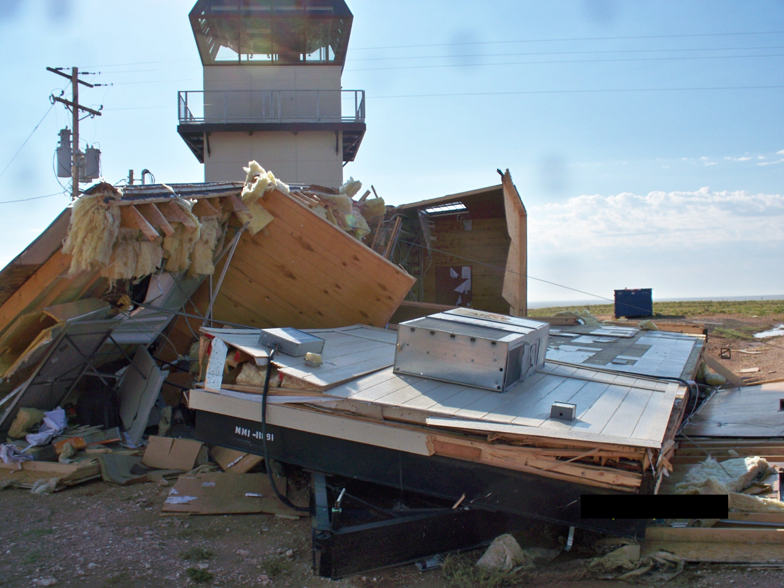
Left: Greater than golf ball size hail fell just southeast of Ramon in De Baca County on May 22, 2017. Photo by Mike Olbinski. Right: This same supercell went on to produce an amazing and colorful mammatus-filled sunset. Photo by Nick Drieschman. June 30th: Though severe storms were not as widespread on this day as they were on May 9th, storm damage was likely greater. By mid afternoon, storms developed to the east of the Sangre de Cristo Mountains and shifted eastward across the northeast plains. Golf ball size hail knocked out the windows of many cars and homes in the small community of Sofia. During the early evening, it became clear that the storms were not diminishing, and rather, additional supercells developed across Lincoln, Torrance and San Miguel counties. The storm in San Miguel County became a long-lived and prolific large hail and extreme wind producing storm as it bowed out across De Baca and Roosevelt counties. An observation at Melrose Range clocked a wind gust of 85 mph while spotters in the area were reporting hail stones up to baseball size! The wind driven hail ripped the siding off homes, and one home owner reported that the hail punctured through their roof and damaged the interior of their residence. Also, a large storage trailer with agricultural goods was blown over and contents destroyed. Several farmers in the area experienced total crop loss from this event. An image of the hail swath and the maximum estimated hail size is available here.
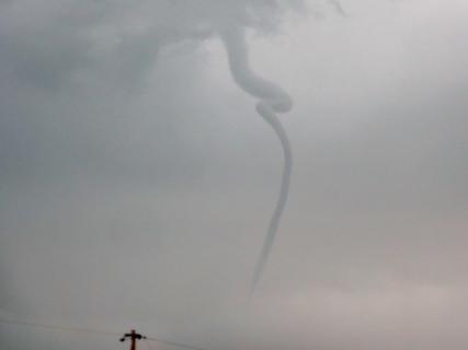
Left: Large hail and high winds pounded the side of this home, rendering the siding useless. Photo by Jenny Essary. Right: Melrose Range contractor office destroyed by 85 mph winds. Photo by Gerry Foisie. August 9th: In a month when we are normally concerned with flash flooding, another round of large hail and tornadoes occurred instead. Storms developed along the east slopes of the Sangre de Cristo Mountains once again and rapidly became severe. A supercell that was slowly shifting toward the southeast increased in intensity right over Las Vegas, dropping baseball size hail near New Mexico Highlands University. Significant damage to vehicles was reported across southeastern portions of town. A tornado developed from a separate supercell near Wagon Mound, but fortunately it was short-lived and no damage was reported. However, later that day, this same supercell was tracking across San Miguel County and it is suspected that it was the cause of a fatal aircraft accident of an individual attempting to reach a private air strip in the area. Other storms that day produced severe weather as well, but nothing quite as interesting as a coiled up funnel cloud near Clayton shown below.
Left: Short-lived tornado southeast of Wagon Mound, courtesy of Chad Hazen. Center: Baseball size hail collected by Crystal Clarisse after it fell across southeastern portions of Las Vegas. Right: Hail damage in Las Vegas. Photo by Fernando Roybal.
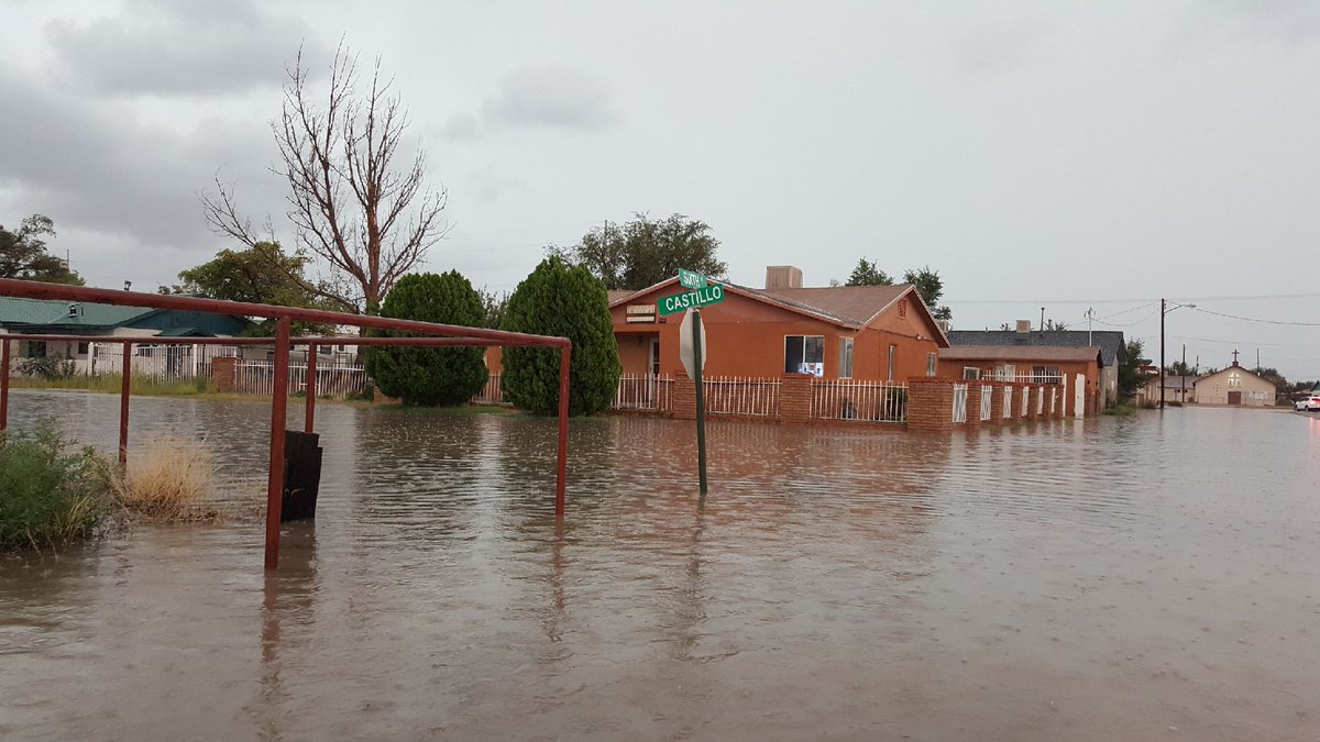
Coiled up funnel cloud near Clayton. Photos courtesy of Risa and Earl Crews September 29th: On September 29th, a cluster of heavy rain and hail producing thunderstorms slowly tracked across central New Mexico, favoring Valencia and Socorro Counties. Flash flooding was widespread across Belen, and Interstate 25 was closed between Belen and U.S. Highway 60 due to flooding over the highway. Mud, rocks, and debris was flowing on to the highway from the mesa to the west. State roads 304 and 116 were also closed due to flooding.
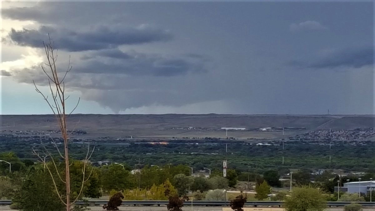
This intersection in Belen was inundated with water due to flash flooding on September 29th. Photo courtesy of KRQE. Worthy of a mention: June 22nd through June 26th was a busy severe weather stretch as well. Several severe thunderstorm warnings for large hail and strong winds were issued each day. The most active day was June 25th when widespread severe storms developed across eastern New Mexico. Tennis ball size hail struck Interstate 40 at State Road 3 producing significant damage and impacts to travel. Numerous vehicles had windshields smashed out and traffic was stopped for over two hours. Emergency response personnel attended to several stranded vehicles with injured motorists. Hail was up to five inches deep and flooding was also reported. Tennis ball size hail fell again on the 26th between Glorieta and Pecos. House windows, skylights, and vehicle windows were blown out. On August 3rd, major damage occurred across Roosevelt County, starting with wind gusts estimated between 80 and 85 mph which tore the roofs of several buildings south of Portales. Hail and high winds also damaged vehicles in the area. These severe winds also downed a one mile stretch of power poles south-southeast of Portales. Metal roofing material was blown several hundred feet away and a large pivot irrigation system was also blown over. Several county roads were under water, damaged, and closed as a result of flash flooding following the high winds. This was the second time this year that Roosevelt County saw wind gusts over 80 mph. Though tornadoes are most common across eastern New Mexico, on September 30th, a tornado developed west of Albuquerque. The tornado briefly touched down along Interstate 40 near State Highway 6, but fortunately no damage was reported. The large wall cloud and associated funnel was observed from the National Weather Service office.
Left: Tennis ball size hail near Glorieta on June 26th. Photo by Wanda Gonzalez. Right: It's not everyday we can see a tornado-producing supercell from the office, but on September 30th, we sure did! Photo by NWS Albuquerque. Finally, flash flooding occurred several times between October 3rd and October 5th. Portions of De Baca County was impacted on both October 3rd and October 5th. On October 3rd, four to six inches of rainfall produced flash flooding in the Alamogordo Creek and Salado Creek drainages. Numerous low water crossings flooded. Additionally, water was running over U.S. Highway 84 around Fort Sumner and several creeks and arroyos were flooding in the area. On October 5th, the rain struck again and several roads in Fort Sumner completely flooded. The railroad underpass at U.S. Highway 84 closed due to flooding and several low water crossings were still flooded the following morning. Also on October 5th, the Rio Penasco rose nearly 10 feet in one hour then crested at 17.46 feet several hours later due to torrential rainfall over the Sacramento Mountains. Nearby roads were inundated with flood waters along State Highway 24 and U.S. Highway 82 in Chaves County. Rainfall in Logan and Portales also caused flash flooding. |
|||||||||||||||||||||||||
|
Severe Stats: All 12 tornadoes across New Mexico were rated EF-0. The largest reported hail size this year were the baseball size hail stones that fell on both June 30th in Roosevelt County and August 9th in San Miguel County. The strongest reported thunderstorm wind gust was the measured 85 mph wind gust at Melrose Range. Additionally, in Hobbs, an estimated 85 mph wind gust occurred on June 23rd. A horse barn was blown into a solar panel array at the New Mexico Junior College. Also, pieces of the HVAC equipment were lifted off the roof of the Albertsons near West Bender Boulevard. The highest non-thunderstorm wind gust was 88 mph at San Augustine Pass in southern New Mexico on January 21st and also at a public weather station directly below Abo Pass at Tierra Grande on February 12th. The latter was due to an east wind. |
|||||||||||||||||||||||||
|
How does 2017 compare to normal? Since 1950, the average number of tornadoes reported in the state is 8 to 9, which makes 2017 just above average. At least one tornado has been reported each year since 1953, and before that it is likely that most tornadoes went unreported. The highest number of tornadoes ever reported was in 1991, when 31 tornadoes devastated parts of the state, especially Eddy and Lea counties. The average number of hail reports has steadily increased since 1950 due to increased awareness, and today the average number of events is near 130. This makes the number of severe hail reports this year well above normal. Complete flash flooding records only date back to 1993, however since then, the average number of flash flooding events is around 40 per year. In 2017, there were 1.5 times the normal number of flash flood events, which often coincided with severe weather events. Reported thunderstorm wind events were also well above the average number of 35 events per year.
|
|||||||||||||||||||||||||
|
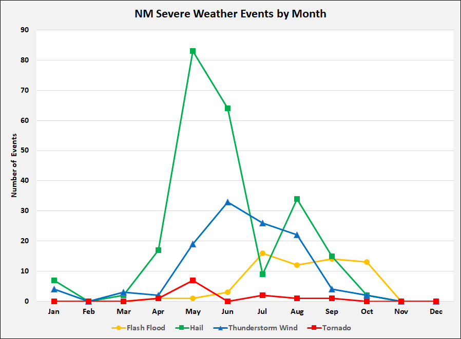
The graph on the left shows the distribution of New Mexico severe weather events by month. New Mexico's primary severe weather season is in the spring, though a secondary season often occurs in the fall. This is primarily illustrated by the hail events this year. This graph also shows that flash flooding in New Mexico is most frequent during monsoon season. Click on the graph for a larger image. |
|||||||||||||||||||||||||
| (Return to the main page) | |||||||||||||||||||||||||


 Follow us on YouTube