| Temperature Jump and Damaging Wind Gust caused by Heat Burst at Clayton | ||
|
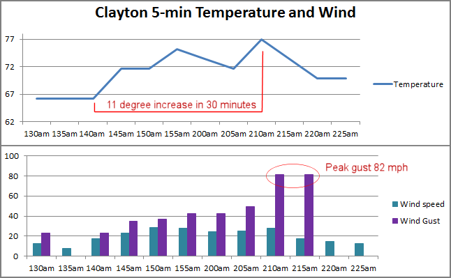
Early on the morning of May 28, 2013, a wind gust of 82 mph at Clayton Municipal Airport (CAO) was noted during a routine check of observations. A closer look at the Clayton observation showed that the temperature had increased rather dramatically from 66°F at 200 am MDT to 77°F at 313 am MDT. 5-minute observations for Clayton were requested, and are shown on the plot below. |
||
 |
||
|
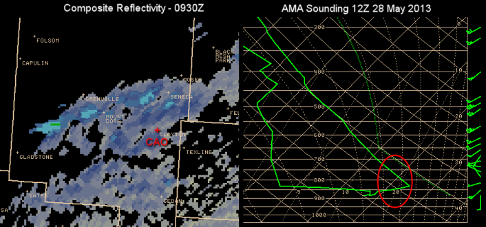
Such observations can be associated with heat bursts, or sudden increases in surface temperature associated with thunderstorms or showers. While there were no thunderstorms in northwest New Mexico during the overnight hours, composite reflectivity (below, left image) did show some weak radar returns, or elevated convective clouds. When the downdrafts associated with precipitation or virga descend through a stable layer, such as the inversion shown on the Amarillo sounding from 2 hours after the event (below, right image), the increase in temperature occurs. Temperatures in the inverstion ranged from 64 to 75 degrees. Gusty surface winds often accompany these events. |
||
 |
||
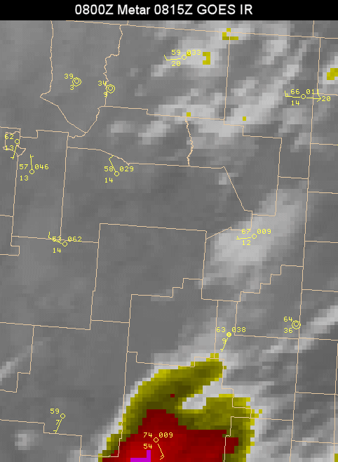 |
NWS Albuquerque has been evaluating new satellite imagery for the past 5 years. The loop to the left is composed of both operational GOES IR imagery with higher resolution IR imagery from the Visible Infrared Imager Radiometer Suite (VIIRS) onboard NASA's newest Earth-observing satellite. The VIIRS imagery has a much higher resolution than the GOES imagery and weak elevated convection is evident in the VIIRS imagery and harder to detect in the GOES imagery. Also shown in these images are the hourly CAO (metar) observations. In the last frame, the peak gust of 71 kts, or 82 mph, is plotted. |
|
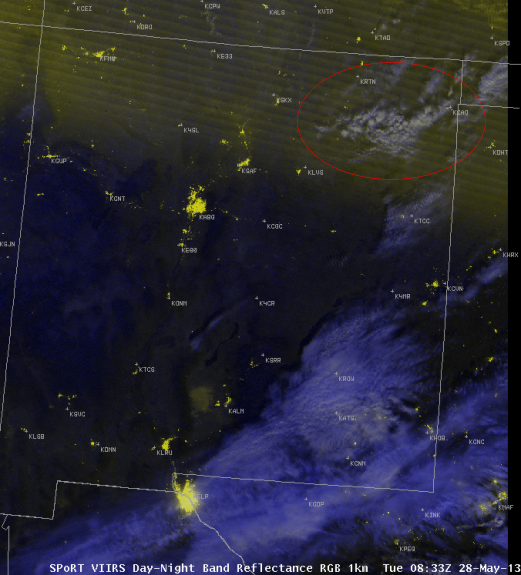 |
Another new satellite graphic being evaluated at our office is produced by the VIIRS Day-Night Band which provides night images of reflected and emitted light at the higher resolution of visibile imagery. The image from 0833Z, or 233 am MDT helped us to differentiate the clouds in northeast New Mexico (red oval, includes Clayton) from those in the southeast corner of the state. Clouds in the northeast show the patterns and texture associated with elevated convection. This convection was likely sufficient to produce a heat burst.
|
|
|
These new satellite products when combined with the 5-minute CAO observations and composite reflectivity convinced forecasters on duty that the 71 kt wind was a valid observation. After sunrise, calls were made to the Clayton area and damage reports included downed tree limbs up to 4 inches in diameter as well as overturnded 50 gallon trash cans. Check out our feature on heat bursts for more information. |
||


 Follow us on YouTube