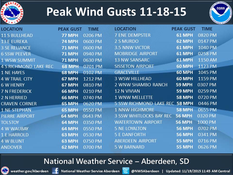
Northwest winds intensified to significant levels on November 18th and 19th across the majority of South Dakota and several surrounding states. A clipper low tracked across northern North Dakota and merged across northern Minnesota with a northeasterly-moving low from the Plains. Gusts above 70 mph along with sustained winds around 50 mph occurred as a result on the 18th, which led to a couple reports of structural damage to roofs across the area. For perspective, EF-0 tornado wind speeds range from 65-85 mph, and hurricane force winds begin at 74 mph. Winds dropped slightly into the upper 50 mph range on the 19th.
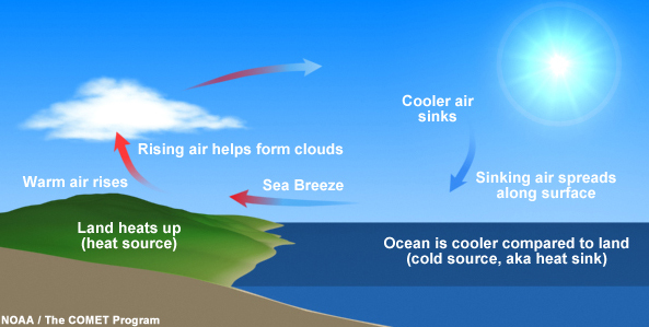
So, why? Let’s start with the basics. Imagine yourself sitting on the beach during summer. Do you feel a cool breeze along with the warm sun? In reality, lake/sea-breezes are very common. This is due to the fact that the water is cooler than the land (it takes more energy to heat). A difference in heating between two areas is what ultimately sets air in motion – wind! The land heats up faster than the water during a typical beach day, so air rises from the shore and sinks above the water. Thus you get low pressure at the shore and high pressure at the water. Air always moves from high to low pressure (physics), so you will generally feel wind coming at you from a large body of water.
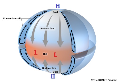
Wind on larger scales, like what we experienced these past couple of days, works in much the same way. In this case we’re dealing with an area spanning across several states. What’s the equivalent to our warm shore and cool lake on this much larger, what we call “synoptic,” scale? Earth’s Equator and Poles, the North Pole in our case. The Equator is warmer because the sun’s rays shine down directly there, as opposed to shining in at a slant (or sometimes not at all) at the North Pole. As a result, like in our lake/shore example, there is a difference in heating between these two areas. Air on a whole rises at the equator (low pressure) and sinks at the North Pole (high pressure). Since air moves from high to low pressure, it’s no wonder why we generally get cold air with northerly winds. BUT wind doesn’t always blow directly from the north to south, right? That’s because, unlike our beach example where the lake and shore are stationary, the Earth rotates! This fact explains why low and high pressure on our synoptic scale rotates, counterclockwise and clockwise respectively. These pressure systems are simply Earth’s way of trying to establish equilibrium by transferring cold air to warm air, granted in a more roundabout way than in our beach example.
But low pressure systems pass near or through South Dakota on a regular basis during the course of a typical month… so why do some lows produce such stronger winds than others, like the one that passed by on the 18th and the 19th? For starters, lows get a head start during the fall and winter. Since the Earth tilts away from the sun in the Northern Hemisphere during this time, the difference in heating between the North Pole and the equator increases (it’s much colder at the North Pole during winter than summer). Therefore high and low pressure systems are generally stronger, so the difference in pressure between them, what we call a “pressure gradient,” is greater. The magnitude of the pressure gradient is depicted by the yellow “isobars,” or lines of equal pressure, on the animated GIF weather map below – the closer together these lines, the stronger the winds. Basically the stronger the pressure systems are, the more the air wants to move/blow from high to low. Now, wind is very weak or even non-existent when you’re directly underneath a low or high pressure system (air goes up or down as opposed to side-to-side), but it’s strongest when you’re right in-between them. By the 19th, a strong low pressure system in Canada was around 975mb and a high pressure system in Kansas was around 1025mb (average is ~1013mb). South Dakota, which was right in the middle, experienced winds so strong they surpassed severe thunderstorm criteria speed (58+ mph)! Why not widespread damage? Trees lose their leaves during the fall so they catch the wind less. Therefore they are less likely to snap, fall, and do damage, which commonly happens with leaf-bearing trees during severe summertime thunderstorms.


 Follow us on YouTube