A major severe weather event unfolded across South Dakota from Friday, June 19th through the early Saturday morning of June 20th. Below is a summary of the information that we have gathered - our focus is on the areas affected within our County Warning Area.
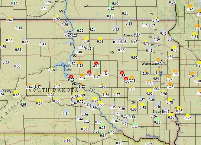
Two rounds of severe weather took place, the first of which across Sully, Hand, and Hyde counties during the afternoon of the 19th. Storms began around 12:30 pm CDT and quickly produced large hail up to 2.00". They proceeded to backbuild and train over the same areas for the next 5 hours, finally exiting Hand county at 5:30 pm CDT. During this time a substantial amount of rain fell leading to some flash flooding. Combined with the rain that fell during the overnight, nearly 10 inches accumulated in locallized areas by radar estimates. Ground measurements have come in at 5.02" near Holabird and 5.67" near Miller.
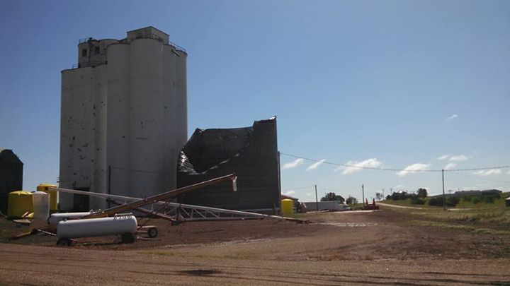
Round two began during the early evening across far eastern Montana and western South Dakota as supercells and developed into a widespread significant windstorm as night fell. Earlier in the day, the Storm Prediction Center (SPC) issued a convective outlook highlighting a Moderate Risk (second highest of 5 categories available) area from western South Dakota into portions of central South Dakota for the risk of severe winds. The SPC then issued a Particularly Dangerous Situation (PDS) Severe Thunderstorm Watch at 10:55 pm, which included Stanley, Jones, Lyman, and Buffalo counties until 4:00 am. During the course of the event, severe wind gusts (58 mph+) were measured as far north as northern Hughes county, but partucularly hard-hit were Jones, Lymann and Buffalo counties. The squall line responsible entered Jones county around midnight and by 12:30 am, several semi trucks had been blown over, two machine sheds were destroyed, power lines were snapped, numerous billboards and road signs were damaged, trailers were flipped over, a grain elevator bin's roof was blown off and side caved in, and many trees were taken out. Much of this damage and more occured in Okaton, Murdo, and Draper and along I-90 as up to estimated 90 mph winds tore through the area. By 12:40 am the storm was in Lyman county where it continued producing up to estimated 90 mph winds, damaging many shingles on roofs and even flipping a pickup truck not to mention more tree damage. By 1:15 am the storm entered Buffalo county and immediately impacted Fort Thompson, where campers were flipped and many trees were downed. Also in Fort Thompson was the destruction of a trailer house which led to a fatality. The storm then impacted the rest of Buffalo county resulting in the destruction of grain bins and a hay shed, plus the de-roofing of a hanger in and around Gann Valley before continuing east into southeastern South Dakota and southwestern Minnesota where it would eventually weaken.
For an interactive map and complete listing of storm reports from across the state, visit https://nwschat.weather.gov/lsr/#ABR,UNR,FSD/201506190500/201506201700/0100.
Rainfall amounts ending on the 20th.
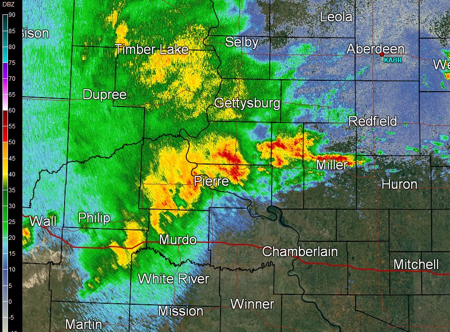
Radar reflectivity of the squall line as it entered Jones County.
A few photos from our Facebook page in Fort Thompson, from CharitynMaurice MerrittnQuigley.

A few photos from our Facebook page in Draper, from Briget Millage Hatheway.


 Follow us on YouTube