Weather History - December 1st
Local and Regional Events:
December 1, 1985:
A storm system with heavy snow, strong winds, and blizzard conditions visited the region on December 1st through 2nd. Most of the snow fell in Minnesota. Snowfall across Minnesota increased from the south during the early morning of December 1st and had spread across most of the state by late morning. Winds in the west-central and southwest parts of the state increased to 40 to 50 mph, causing blizzard conditions. By late morning, drifts had reached 3 feet, and snowplows were pulled off roads from the southwest into central Minnesota due to restricted visibilities. The winds continued through the evening, gradually diminished during the morning of December 2nd. High winds and cold temperatures broke power lines and caused power outages over portions of southern and west-central Minnesota during the afternoon of December 1st and December 2nd. Many highways were impassable, and numerous businesses and schools were closed on the morning of December 2nd until residents could dig out. There were a few travelers that became stranded for up to 6 hours in their vehicles. Traffic accidents also accounted for some injuries and a few deaths. Further west, in South Dakota, strong winds gusted to around 40 mph and produced ground blizzard conditions over most of the state. The low visibilities, road conditions, and strong winds stranded a family for 25 hours south of Colome in Tripp County and another family for eight hours near Lee's Corner in Brule County. Many roads were blocked in the state's central and western parts, and no travel was advised in the east. The blowing and drifting snow reduced visibilities to near zero, and many accidents were reported. The strong winds, along with the previous day's snowfall, caused some damage, including the collapse of the roof of a large barn south of Bemis in Deuel County. Many church services were canceled on December 1, as were many schools on December 2. Temperatures became frigid during the morning of December 2 in the northwest part of the state. Camp Crook in Harding County reported a low of -36 F. Pierre had 2 inches of snow, Aberdeen, Castlewood, Clark, and Redfield had 3 inches, Bryant had 4 inches, Clear Lake, Milbank, and Wilmot had 8 inches. Timber Lake fell to -24F on the 2nd while McLaughlin fell to -30F.
December 1, 1992:
A storm system caused numerous traffic accidents and stranded several hundred travelers on December 1st across northeast South Dakota and west-central Minnesota as Interstate 29 was closed between Watertown and Sisseton. Slush on roadways became ice as high wind gusts were up to 60 mph, and snowfall of one to four inches brought blizzard conditions to some areas. Several semi-trucks jackknifed, and many cars ran into ditches, causing minor injuries. Simultaneously, strong northwest winds further west in central and north-central South Dakota gusted up to 67 mph on the 1st. The high winds shattered windows and blew down trees and signs. The wind rolled a van into a car, causing damage to both vehicles. A wind-blown dumpster damaged another vehicle. The wind also blew toppers off several pickup trucks, causing some damage.
December 1, 2007:
A strong low-pressure area moving across the central plains brought widespread snowfall of 6 to 12 inches across northeast South Dakota. The snow began between 4 and 8 am and ended between 7 and 9 p.m. on December 1st. The heavy snow mainly affected travel and Saturday activities. Snowfall amounts included 6 inches at Clark, Conde, Faulkton, Redfield, and Watertown, 7 inches at Groton, Roscoe, and Sisseton, 8 inches at Britton, Summit, Bryant, 9 inches at Aberdeen and Kidder, and 12 inches at Big Stone City.
U.S.A and Global Events for December 1st:
1962: The 50th Grey Cup was played in Toronto, Ontario, between the Hamilton Tiger-Cats and the Winnipeg Blue Bombers. Severe lakefront fog halts the game with 9:22 left to play on December 1st. Winnipeg wins the Fog Bowl the following day by a score of 28-27. Click HERE for more information from the NWS Office in Louisville, Kentucky.

1970: Four tornadoes impacted east-central Wisconsin during the morning hours. The strongest tornado, an F3, formed at 10:15 AM near Medina in Outagamie County. The twister moved northeast at 50 mph and destroyed twenty barns and five houses. Click HERE for more information from the NWS Office in Green Bay, Wisconsin.
2006: A winter storm produced more than 6 inches of snow along a 1,000-mile-long path from central Oklahoma to northern Michigan from November 30-December 1st. The storm also produced significant freezing rain, which impacted the St. Louis area. An estimated 500 or more homes and businesses were without power in the St. Louis area after this storm. Click HERE for more information from the University of Illinois. Click HERE for more information from the NWS office in St. Louis, Missouri.
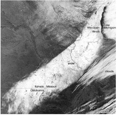
Polar-orbiting satellite image of the snowfield. The image above is courtesy of the University of Illinois.
2017: Several waterspouts formed off the coast of San Remo in northwest Italy. One waterspout moved ashore and caused damage in town. Click HERE for pictures from the website, Severe Weather Europe.
Click HERE for more This Day in Weather History from the Southeast Regional Climate Center.


 Follow us on YouTube