Weather History - February 17th
Local and Regional Events:
February 17th, 1962:
Very heavy snow of 20 to 30 inches fell across the southeastern half of South Dakota. One location had 44 inches of snowfall from the storm. Everything was shut down due to the storm, including roads, schools, and businesses. Some snowfall amounts included 10 inches at Bryant, 11 inches at Miller, 20 inches at Mitchell, 21 inches at Redfield, 23 inches at Huron, and 32 inches at Sioux Falls.

The surface map above is from February 18th, 1962, at 7 am.

February 17th, 1972:
In Minnesota, high winds of 30 to 50 mph across southern and central Minnesota reduced visibilities to zero at times from blowing snow. Wind gusts of 90 mph were reported at Worthington and Fairmont. Snow of 2 to 6 inches fell across the state. The blizzard stopped almost all traffic from west-central through the south-central part of the state. Most schools in the area were closed. Dozens to hundreds of people were stranded in nearly every town. Many communities stopped all traffic from leaving town. The snow derailed a train at Butterfield. In South Dakota, freezing rain followed by snow accompanied by winds of over 60 mph produced hazardous driving conditions in the area. Traffic was brought to a standstill in many areas resulting in cancellations of school and other activities. Some accidents occurred due to the icy roads. Although the snowfall was light, strong winds caused drifting with visibilities to near zero at times.
February 17th, 1991:
On February 17th, a significant snowstorm dumped massive amounts of snow on most of the state from the Black Hills, southwest, central, east-central, and the northeast. At the storm's end, parts of the black hills received up to 2 feet of snow while the rest of the affected area had between 8 and 15 inches. The heavy snow caused most of Interstate 90 west of the Missouri River to close and many other highways in the central part of the state. In addition, many cars and trucks skidded off the roads, causing many minor injuries. The only serious injury was a man rolled his vehicle over after losing control near Belvidere.
U.S.A and Global Events for February 17th:
1894: According to Grazulis, an estimated F2 tornado hits 5 miles south of Warren, Arkansas. An older woman was killed in one of the small homes that were destroyed. In addition, fruit trees were ripped out and carried a half-mile. Another tornado, estimated F3, killed two people in Claiborne County, Louisiana.

The image above is from a tweet by the NWS office in Little Rock, Arkansas.
1926: A deadly avalanche, Utah's worst, demolishes 14 miner's cottages and a three-story boarding house in Bingham Canyon. Thirty-six were killed and 13 injured.
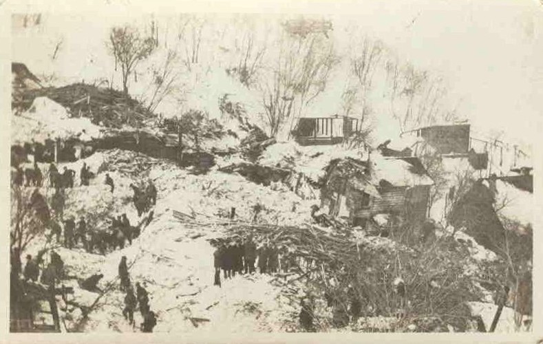

The images above are from the website, GenDisaster.com
1958: From the 14th through the 17th, one of the most significant snowstorms of the mid 20th century struck the northeastern U.S. The storm produced 30 inches of snow in the interior of New England, including more than 19 inches in 24 hours at the Boston Airport. The same storm produced up to three feet of snow in the Middle Atlantic Coast Region, with 14 inches in Washington D.C. and 15.5 inches in Baltimore, Maryland. The storm resulted in 43 deaths and 500 million dollars damage over the Middle Atlantic Coast States.
1973: Snow showers moved across southeast Texas, with most locations only reporting snow flurries. However, the Houston Intercontinental Airport measured 1.4 inches of snow.
Click HERE for more This Day in Weather History from the Southeast Regional Climate Center.


 Follow us on YouTube