Weather History - February 20th
Local and Regional Events:
February 20th, 1962:
A round of heavy snow fell across the southeastern half of the state from the 20th through the 22nd, producing 10 inches. Snowfall amounts included 5 inches at Bryant, 6 inches at Kennebec, 7 inches at Redfield, Brookings, Mitchell, and Sioux Falls, 8 inches at Miller, and 10 inches at Huron. Snowfall amounts for the record-setting month of February 1962 ranged from 30 - 50 inches across much of the southeast part of the state.
February 20th, 1997:
Warm weather resulted in snowmelt runoff and ice breakup on the Bad River. As a result, the Bad River went above flood stage from Capa to Fort Pierre late in the evening of the 20th. The flood stage at Fort Pierre is 21 feet, and the river rose to around 25 feet on the 21st. The Bad River went below flood stage during the afternoon of the 22nd. Lowlands near the river were flooded along with some county roads, with some of the roads damaged. Late in the evening of the 20th, the trailer court on the southern edge of Fort Pierre was evacuated, where they did some sandbagging. Also, on the west side of Fort Pierre, some roads were flooded.
February 20th, 2011:
The snowfall/blizzard event on 20-21 February 2011 produced yet another round of impressive snowfall totals across central and northeastern South Dakota and west-central Minnesota. Storm total snowfall amounts ranged from 8" to 12" with locally higher amounts of more than 18" reported in a few locations. Click HERE for more information.
U.S.A and Global Events for February 20th:
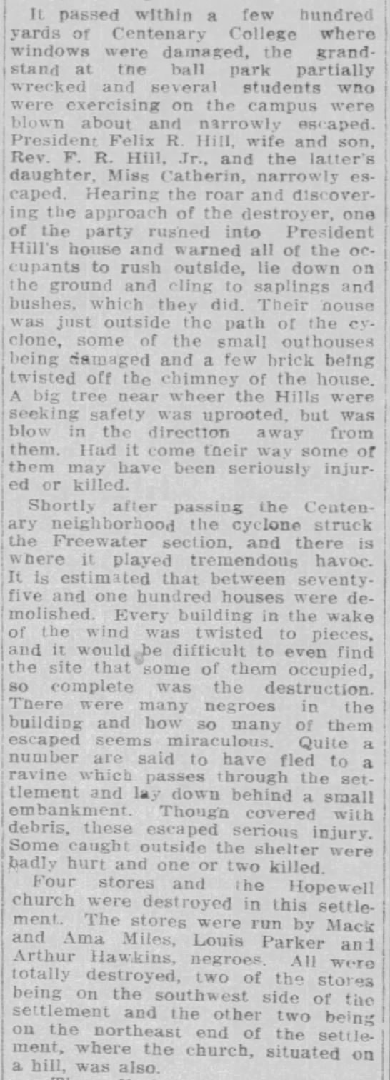
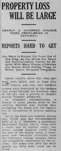
1912: A strong area of low pressure produced snow in Amarillo and high winds to Austin, Texas. In the warm sector of the low, severe storms developed and produced an estimated F3 tornado in Shreveport, Louisiana. The tornado killed nine people and injured 50 others. The tornado passed near Centenary College, where windows were damaged, and the grandstand at the ballpark was partially damaged. In addition, significant damage occurred in the Freewater section, where an estimated 75 to 100 houses were demolished. Click HERE for more information on the Austin, Texas wind storm from the Monthly Weather Review.
1912: During the 20th and 21st, a severe snowstorm attended by high winds lasting from 34 to 30 hours swept over Illinois, Indiana, and Ohio. The amount of snow that fell in this storm was not only large, but it drifted severely. In many places, snowbanks 5 feet and higher were formed, railroad cuts were filled, highways in many places were impassable, electric service wires of all kinds were temporarily put out of commission, all trade and traffic generally demoralized. This snowstorm was part of a general disturbance that developed over the southwest on the 20th and moved northeastward over the Central and Eastern States, increasing in strength during the 21st and 22nd, and which proved to be one of the most severe and most extensive general disturbances that have passed over this section of the country for several years past. Besides the heavy snow in the northern part of the storm, heavy rains, gales, and destructive thunderstorms attended over most of the southern and eastern portions. Wind velocities of 50 to 75 miles per hour were reported at many places during the passage of this storm. Some wind blew steadily at high velocities for several hours. Click HERE for more information from the Monthly Weather Review.
1995: The temperature at the Civic Center in Los Angeles, California, soared to 95 degrees, the highest ever recorded at the location during February.
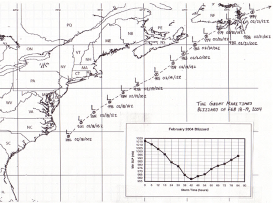
2004: A nor'easter brought heavy snow and strong winds to Nova Scotia and Prince Edwards Island from February 17th through 20th, 2004. The Maritimers called this storm White Juan, a hurricane disguised as a blizzard. Halifax, Yarmouth, and Charlottetown broke all-time 24-hour snowfall records, receiving about 3 feet of snow. The 34.8 inches of snow on February 19th nearly doubled its previous record for a single day for Halifax. The map below is from "The Great Maritimes Blizzard of February 18-19, 2004" by Chris Fogarty from the Atlantic Storm Prediction Centre, Dartmouth, Nova Scotia.
Click HERE for more This Day in Weather History from the Southeast Regional Climate Center.


 Follow us on YouTube