Weather History - February 21
Local and Regional Events:
February 21, 1918:

February 21, 1969:
Heavy snow and winds of 15 to 25 mph caused blowing and drifting snow, which closed many roads. Snowfall amounts of 5 to 12 inches were typical across eastern South Dakota from the 20th to the 22nd. Some snowfall amounts included 5 inches at Clear Lake and Brookings, 6 inches at Wilmot, 7 inches at Milbank, Redfield, and Mitchell, 8 inches at Conde, and 9 inches at Webster, Sioux Falls, and Huron.
U.S.A and Global Events for February 21th:
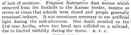
1935: Frequent dust storms occurred in eastern Colorado during the month, forcing schools to close and people to stay indoors. A fatality happened on this date when two section cars collided on the railroad near Arriba Colorado due to poor visibility.

1971: A tornado outbreak struck portions of the Lower Mississippi River Valley and the Southeastern United States on February 21–22nd. The two-day tornado outbreak produced at least 19 tornadoes, probably several more, primarily brief events in rural areas, and killed 123 people across three states. The tornadoes "virtually leveled" entire communities in the state of Mississippi.

In Mississippi, the storms killed 107 people, injured 1,060, and hospitalized 454 others. On March 23, 1971, the Mississippi Civil Defense Council estimated 17 million dollars in property damages. In addition, 131,308 individuals received disaster service from the Salvation Army in nine areas. As of 1971, in terms of fatalities, the outbreak produced the fourth-highest number of deaths in Mississippi from tornadoes on one day. The top five tornado events include 317 deaths on May 7, 1840, in Natchez, 216 deaths on April 5, 1936, in Tupelo, 160 deaths on April 20, 1920, in the northeast and east-central Mississippi, 107 deaths from the Mississippi Delta outbreak on February 21, 1971, and 100 deaths on April 24, 1908, in Lamar to Wayne Counties.
Aerial surveys showed that most storm reports from various sources fit into three main tracks. The surveys also found three principal tornadoes contributed to over 300 miles of tornado track, varying in width from 1/4 miles to more than 1/2 mile. One track extended 159 miles as a continuous storm, beginning southwest of Cary, passing west of Belzoni, Greenwood, and Oxford, with the tornado lifting near Abbeville. After passing over Abbeville, the tornado redeveloped to the southwest of Bethlehem in Marshall County and continued northeast to Selmer, Tennessee. Another tornado first developed near Delhi, Louisiana, and continued 102 miles to near Schlater, Mississippi. The tornado struck the towns of Delta City, Inverness, and Moorhead. A third major storm began south-southwest of Bovina, passed through Little Yazoo, and ended near Lexington for a path length of 69 miles. Although much shorter, about eight miles, a fourth track extended from north of Drew to near Rome.
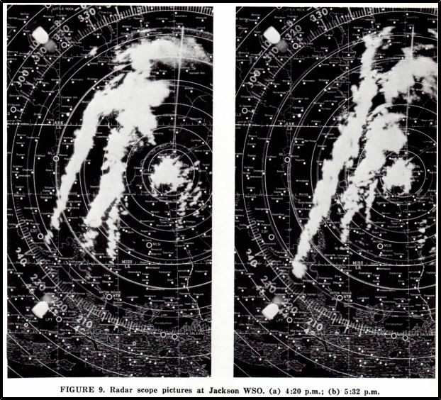
The three significant tornadoes traveled at speeds of 50 to 60 mph. The speed was determined from a selected set of more reliable checks at various locations. All the death occurred along these three tornado tracks. Between 11:56 am and 9:00 pm, the Jackson, Mississippi River radar showed hook echoes in 28 observations. Some of the hooks were as far away as 90 miles. At one time, as many as four hook echoes were observed on the radar.
The Mississippi State Department of Education indicates more than $1.2 million in damages to schools and their contents. At nine canteen sites established by the Salvation Army, there were 94,337 food servings through March 8, 1971. The Mississippi Power and Light Company reported its most significant wind damage in company history. A total of 68 115,000 volt transmission line structures were downed at 14 different locations, with damage that exceeded $290,000, with about 50 percent in Humphrey County and 40 percent in Sharkey County. The South Central Bell Telephone Company's losses exceeded $300,000. They lost 4,600 telephones, 3,250 long-distance circuits were affected, and 205 telephone poles were destroyed. Ten exchanges were on emergency power. The American Telephone and Telegraph Long Lines department lost its microwave tower adjacent to Bentonia, and 1,800 circuits were affected.
At Inverness, at about 4:40 pm, a powerful tornado destroyed 90 percent of the small business district, and 75 percent of the homes were damaged. The storm caused 21 fatalities. Officials noted 153 homes destroyed, 52 had major damage, and 90 received minor damage. The businesses destroyed or damaged in Inverness totaled 61, and farm buildings destroyed was 30. In and near Inverness reports that some people sought shelter from the oncoming tornado by getting in bathtubs, curling up in mattresses, and crawling into haystacks. The tornado was reported to have struck for about 2 minutes, and all electrical powerlines, telephone, and water lines were destroyed. A man who resides on the north edge of Inverness told the newspaper, "At first, just before the storm, it was very quiet and calm...Then I heard (the tornado) for about 3 minutes before I saw it. It was a big funnel cloud..." The Indianola newspaper noted that along the path of the tornado, there was "lots of debris, that is visible on cropland, especially warped tin and larger pieces of lumber."

A tornado struck south-southwest of Bovina at about 5:06 pm and, during a 3-mile track, killed a man and his wife. A man to the south of Bovina "went out on the porch and looked down the road and saw the storm coming.: It was a "half mile down the road." There was "an unnatural calm" just ahead of the storm. "We could hear it coming through and could see lumber and debris flying in the air. It was yellow in the center."
A tornado struck Holmes County at about 6:10 pm. The Lexington newspaper noted, "A tornado touch down in the southwest corner of Holmes County in the Bronzville community. The damage in the Brozville area was not extremely heavy but caused extensive damage to barns, chicken houses, sheds, and a few homes." The tornado apparently lifted afterward and rose above Lexington as the storm continued to the northeast.
Another tornado crossed Yalobusha County from 5:53 pm to 6:23 pm. The cooperative weather observer at Water Valley wrote, "The damaged area, Cascilla (Tallahatchie County) to Tillatoba (Yalobusha County) was about 200 yards wide, but as it moved across Yalobusha County, it began to narrow and tip along, just bumping here and there." As the tornado crossed Highway 315, four miles northeast at the north end of the Yacona River bridge, it was no more than 150 feet wide. The timbered Yacona River bottom areas had roofing material, wallpaper, and insulation from least as far away as Tillatoba. The winds carried many items for some distances. A report was received that checks and/or portions of checks from the Bank of Anguilla, Sharkey County, were found in Panola County, around 140 miles away.

Sources:
NOAA (July 1971b), Mississippi Delta Tornadoes of February 21, 1971 (PDF), NOAA Natural Disaster Survey Report 71-2, Rockville, Maryland: United States Department of Commerce
4th ANNUAL EARTH RESOURCES PROGRAM REVIEW
NOAA; Saltsman, E. J. (1971), written at Jackson, Mississippi, "Special Weather Summary," Climatological Data, Asheville, North Carolina: United States Department of Commerce, 76 (2): 15–8
2013: An astonishing 515 cm (202.8" or almost 17') level of snow depth was measured at Sukayu Onsen, Aomori on Honshu Island in Japan, on February 21, 2013, the deepest snow measured at an official weather site in Japan records. (Last Updated in 2020). Click HERE for more information from Weather Underground.
Click HERE for more This Day in Weather History from the Southeast Regional Climate Center.


 Follow us on YouTube