Weather History - January 2nd
Local and Regional Events:
January 2, 1999:
Heavy snow of 6 to 8 inches fell across part of northeast South Dakota from the late afternoon hours of the 1st to the early morning hours of the 2nd. Strong north winds of 15 to 30 mph combined with temperatures in the single digits generated wind chills from 25 to 40 below and visibilities below 1/4 of a mile at times. Holiday travel along Interstate-29 and Highway 12 was most affected by this winter storm. There were some travel delays and some stranded motorists as a result. Some snowfall amounts included 6 inches at Kidder, Victor, Sisseton, Webster, Waubay, Wilmot, and 8 inches at Britton and near Peever.
U.S.A and Global Events for January 2nd:
1839: It is believed Louis Daguerre took the first daguerreotype of the moon. Unfortunately, in March of that same year, his entire laboratory burnt to the ground, destroying all his written records and much of his early experimental work–and that historical image of the moon. A year later, John William Draper, an American doctor, and chemist took his own daguerreotype of the moon. Click HERE for more information from APS Physics.
1897: Tornadoes in January? Two tornadoes touched down on this day. The first tornado touched down in Mooringsport, Louisiana, killing five people and injuring 21 others. The second tornado occurred at Benton, Arkansas. Although this tornado was more destructive in regards to property damage, it caused one death.
1949: A blizzard raged and brought heavy snow, strong winds, and cold temperatures to South Dakota, Wyoming, Colorado, and Nebraska.
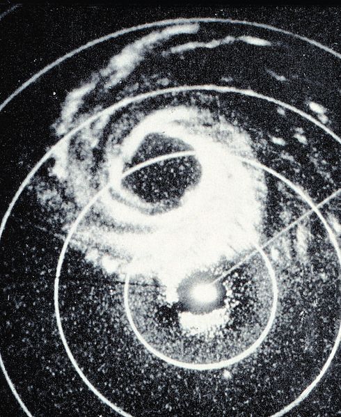
1955: Hurricane Alice passed through the Islands of Saint Martin and Saba in the Caribbean Sea on this day. Alice, which developed on December 30, 1954, is the only known Atlantic hurricane to span two calendar years. The image below is courtesy of the NOAA Photo Library.
1999: A powerful winter storm developed over the Texas panhandle and moved northeast through the Missouri bootheel and then north northeast through eastern Illinois and into Michigan. Snow began accumulating in east-central Illinois and areas south of Chicago during the early evening hours of New Year's Day and overspread the city and north suburbs by midnight. Snow continued through the night and much of the day Saturday, January 2. The heaviest snow fell during the daytime hours Saturday and tapered off by late afternoon or early evening and ended by late evening. Northeast winds were 20 to 30 mph with a few higher gusts during the day Saturday. Winds gusted to over 50 mph along the Lake Michigan shoreline. The strong wind coming off the lake enhanced snowfall totals within about 10 miles of the lake. Snowfall was generally 9 to 15 inches over north central and east central Illinois and in the Chicago suburbs. Snowfall in Chicago and the north suburbs in Lake County was 18 to 22 inches. Winds subsided Saturday evening as the storm center passed over southern Lake Michigan. Then strong northwest winds developed Sunday, causing considerable blowing and drifting and hampering clean-up efforts.
The 21.6 inches at O'hare, the official observing site for Chicago, was the second greatest storm total snowfall. The record was 23.0 inches January 26-27, 1967. Of the 21.6 inches, 18.6 fell on January 2, setting a record for the most snowfall on a calendar day. Other snowfall amounts included; Algonquin 14.0, Aurora 14.4, Barrington 18.0, Brookfield 15.1, Bourbonnais 14.0, Channahon 13.0, Chatsworth 17.0, Coal City 13.0, Compton 9.7, Crestwood 14.2, DeKalb 12.4, Dixon 16.4, Earlville 11.3, Fairbury 13.0, Geneva 13.0, Glenwood 16.0, Harvard 9.0, Lake Villa 17.9, LaGrange Park 15.0, Midway Airport 20.6, Mundelein 10.0, Naperville 11.0, Olympia Fields 15.8, Orland Park 13.8, Rochelle 9.6, Rockford 9.0, Streamwood 14.0, Willow Springs 12.0. The heavy snow and blowing snow caused hazardous travel. Lake Shore Drive was closed down for the first time ever. State, county, and local road crews worked around the clock. The City of Chicago Department of Streets and Sanitation spent 12 million dollars on snow removal efforts. Three hundred flights were canceled at O'Hare and Midway airports.
2006: Six tornadoes impacted central and northern Georgia. The tornadoes were rated from F0 to F3. Click HERE for more information from the NWS Office in Peachtree City, Georgia.
2017: 36 confirmed tornadoes impacted the Deep South from Louisiana to Georgia. Many of the tornadoes came from line segments of storms known as quasi-linear convective systems. A larger convective system also created numerous wind damage reports, and in Alabama, four people died from straight-line winds. Click HERE for more information by USTornadoes.com
Click HERE for more This Day in Weather History from the Southeast Regional Climate Center.


 Follow us on YouTube