Weather History - January 3rd
Local and Regional Events:
January 3, 1997:
A powerful area of low pressure and deep Arctic high pressure brought almost all winter elements to central and northeast South Dakota and west-central Minnesota from the afternoon of the 3rd to the morning of the 5th. The storm began with widespread freezing rain, mainly over northeast South Dakota and west-central Minnesota, where significant accumulations of ice occurred on roads, trees, and power lines. Late in the evening of the 3rd, the freezing rain changed to sleet and then snow, with substantial snowfall accumulations of 6 to as much as 27 inches by late on the 4th. As the Arctic high pressure pushed in through the morning and afternoon of the 4th, northwest winds increased to 25 to 45 mph gusting to 55 mph, creating widespread blizzard conditions, drifts up to 20 feet, and wind chills from 40 to 70 below. The massive accumulation of ice and snow across parts of central and mainly across northeast South Dakota resulted in the roof collapse of over 150 rural buildings. The roofs collapsed onto farm machinery and livestock with a lot of the machinery damaged and a lot of animals injured or killed. The collapse of so many buildings from snow and ice was believed to be the first in this area. On most other buildings, the snow had to be shoveled or blown off. One man was killed in west-central Minnesota as he was trying to shovel snow off the roof of a building. One roof collapse near Lake Poinsett, seven west of Estelline, killed four horses, damaged a boat, and flattened a car. The significant snow drifts buried a few homes during the storm. Many power outages also occurred across parts of central and northeast South Dakota as power lines and poles were downed from the heavy ice accumulation. Some people were without power for several days in the extreme cold conditions. The cities of Miranda, Rockham, Zell, Garden City, Bryant, Vienna, Glenham, Hazel, and other cities were without power for many hours. Some of the communities were out of power for up to 2 days.
In Aberdeen, heavy snow blocking a furnace exhaust vent sent three family members to the hospital for carbon monoxide poisoning. Also, in Aberdeen, the snowmobile club, the drift busters, were called upon for the first time in several years to deliver medicine, take patients to the hospital, and carry essential workers to work and home. Emergencies were challenging to respond to, making many hours to short distances. Throughout central and northeast South Dakota, many businesses and grocery stores were closed. Interstates 29 and 90 were both closed for a few days, along with most state highways. The rest of the roads were either blocked by huge drifts or had one-lane traffic. Snowplows were called off the streets until conditions improved, and when they did start to clear the roads, they worked 12 to 18 hour days. Many vehicles went into the ditch, with mainly minor injuries. Some people had to be rescued. Travelers and truckers were stranded for several days until the roads opened. When Interstate-29 re-opened, there was a logjam of vehicles for 3 miles. One Watertown policeman said he has never seen an impasse as bad as this in 28 years. Area airports were closed, or flights were canceled or delayed. The mail was delayed for several days, most activities were canceled or postponed, and many schools closed on the 6th. The heavy snowfall from this storm brought the widespread snowpack up to 2 to 5 feet. For the winter season so far, the area had record snowfall and recorded cold. Some of the snowfall amounts include 6 inches at McLaughlin, 8 inches 22 SSW Keldron and 4 NW Onida, 9 inches at Pollock, Timber Lake, Highmore, Mobridge, and Kennebec, 10 inches at Castlewood, Clear Lake, Miller, Fort Thompson, and Clark. Snowfall amounts of 1 to over 2 feet include 12 inches at Eureka, and Redfield, 13 inches at Selby and Aberdeen, 14 inches at Pierre and Roscoe, 15 inches at Ortonville MN, 16 inches at Mellette and Browns Valley, MN 18 inches at Faulkton and 1 ENE Stephan, 20 inches at Webster, 22 inches at Britton, 24 inches at Sisseton, 26 inches 10 NW Britton, and 27 inches at Wheaton.
U.S.A and Global Events for January 3rd:
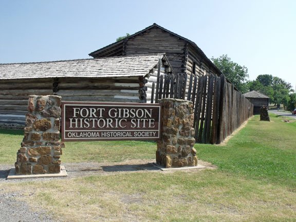
1824: The oldest known weather information in Oklahoma begins on this today at Fort Gibson in 1824. Now known as Muskogee County. The image below is from a tweet by Meteorologist Ryan Granger.
1883: A remarkably brilliant meteor display occurred on the night of January 3rd. The phenomenon was observed at stations in Wisconsin, Michigan, Missouri, Iowa, Illinois, Indiana, and Ohio. This meteor was described as having resembled a large, bright ball of fire. The information is from the Monthly Weather Review.
1886: A severe ice storm struck portions of northeastern Iowa when heavy accumulations of freezing rain brought down trees and branches across the area. An observer near Garnavillo in Clayton County wrote that "the rain...mostly froze as it fell, and coated twigs of trees with ice an inch thick, and many trees were seriously broken. Our telephone wires were broken in many places. Large old trees and large limbs broken. In the woods, many trees bent their tops, so the ground and the roads were impassible until the treetops were cut off." In Fayette County, it was reported that "ice formed on the trees so thick that many limbs, from four to eight inches through, were broken and the tops of the trees, thirty feet high, rested on the ground in many instances blockading the roads." An observer at Waukon noted that "ice formed on the trees to such an extent that in very many cases our shade trees were ruined. All afternoon and night, it was a continual crash."
1949: During the late afternoon hours, an estimated F4 tornado destroyed Warren, Arkansas. The tornado killed 55 people and injured more than 250 others. The destruction of the Bradley mill displaced 1,000 employees.
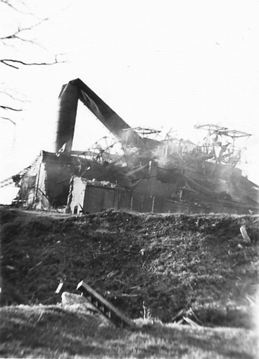
The image above is courtesy of the website, Ancestry.com.
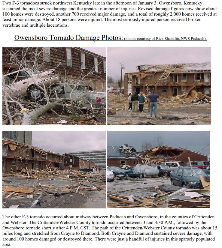
2000: Two F3 tornadoes struck northwest Kentucky late in the afternoon of January 3. Owensboro, Kentucky, sustained the most severe damage and the highest number of injuries. Click HERE for more information from the NWS Office in Paducah, Kentucky.
2004: The Mars Exploration Rover A, also known as “Spirit,” landed on Mars. Over its approximately 6 year mission, Spirit returned about 124,000 photographs from the surface of the red planet. Click HERE for a tweet by the NASA History Office.
2018: The first time in 28 years, light snowfalls in Tallahassee, Florida. The NWS Office in Tallahassee measured 0.1" of snow/sleet at 8:30 am. Click HERE for a tweet by Mike Seidel. Snow also fell in Charleston, South Carolina.
Click HERE for more This Day in Weather History from the Southeast Regional Climate Center.


 Follow us on YouTube