Local and Regional Events:
January 6, 1962:
Snow, high winds, sub-zero temperatures, and near blizzard conditions caused hazardous driving conditions across the area from the 6th into the 9th. Snowfall of generally 2 to 6 inches with winds of 30 to 40 mph caused widespread low visibilities along with drifts up to 4 foot high across central and northeast South Dakota.
January 6, 2010:
A strong Alberta Clipper system tracked southeast through the northern plains on Tuesday night, January 5th through Thursday, January 7th. Sufficient Pacific moisture interacted with bitter cold Arctic air surging south from Canada, resulting in widespread snowfall over northeast South Dakota. Snowfall amounts ranged from 6 to 11 inches. The snow began across northeastern South Dakota in the late evening of the 5th into the early morning hours of the 6th. Many schools closed on the 6th and the 7th. Some snowfall amounts included 6 inches in Andover and Doland; 7 inches in Britton, Sisseton, and near Milbank; 8 inches in Aberdeen, Bryant, and near Summit; 9 inches at Wilmot and Castlewood; 10 inches in Clear Lake and 11 inches at Watertown. Click HERE for more information.
January 6, 2014:
The coldest air in recent history moved into the region during the early morning hours of the 5th and continued into the afternoon hours of the 6th. The combination of sub-zero temperatures with north winds produced dangerously cold wind chills from 40 below to around 55 degrees below zero. Winds gusted to over 40 mph at times. Several area activities were canceled, as well as many schools on Monday the 6th. Some of the coldest wind chills include; 56 below in Summit; 55 below near Hillhead; 54 below in Brandt and Webster; 53 below in Clear Lake; 52 below in Herreid; 51 below in Leola; 50 below in Watertown, Sisseton, Bowdle, and McIntosh. Click HERE for more reports.
U.S.A and Global Events for January 6th:
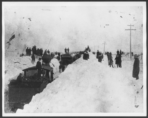
1886: The "Great Blizzard of 1886" struck the Midwest with high winds, subzero temperatures, and heavy snowfall. These conditions caused as many as 100 deaths, and 80% of the cattle in Kansas perished. Click HERE for more information from the Kansas Historical Society. Click HERE for more information from the NWS Office in Dodge City, Kansas.
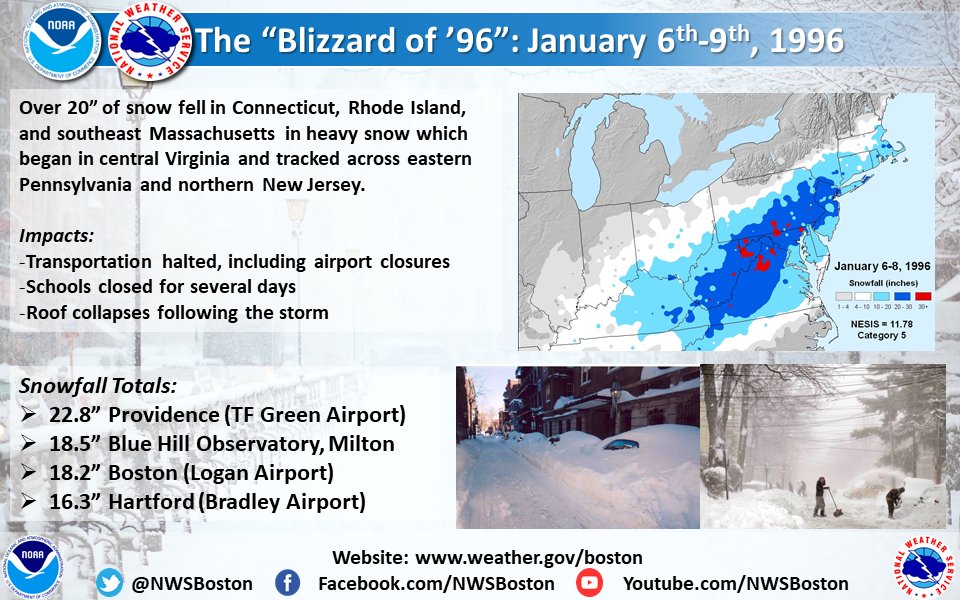
1996: A severe nor'easter paralyzed the East Coast from January 6 to the 8. In Washington D.C., this storm is also known as the "Great Furlough Storm" because it occurred during the 1996 federal government shutdown. Snowfall amounts from this event include 47 inches in Big Meadows, Virginia; 30.7" in Philadelphia; 27.8" in Newark; 24.6" at the Dulles International Airport; 24.2" in Trenton; 24" in Providence; 22.5" in Baltimore; 18.2" in Boston; 17.1" in D.C.; and 9.6" in Pittsburgh. Click HERE for more information from History.com.
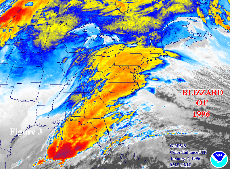
The image below is from a tweet by the NWS Office in Boston, MA.
Click HERE for more This Day in Weather History from the Southeast Regional Climate Center.


 Follow us on YouTube