Weather History - January 28th
Local and Regional Events:
January 28, 1983:
Freezing rain coated much of eastern South Dakota with up to a half-inch accumulation before it changed over to light snow from the late evening of the 28th to the late evening of the 29th. The combination of ice, light snow, and powerful winds made travel extremely difficult. Numerous accidents and stranded vehicles resulted. Visibilities were near zero at times.
January 28, 1996:
Extreme wind chills developed across central, north-central, and northeast South Dakota, and west-central Minnesota as cold arctic air moved in behind an area of low pressure. With temperatures falling well below zero and northwest winds increasing to 20 to 35 mph, wind chills dropped to 40 to 70 below throughout the night of the 28th and into the evening of the 29th. Two to five inches of snow had fallen across the area. The strong northwest winds caused areas of blowing snow, significantly reducing visibilities. Big Stone and Traverse counties experienced a blizzard for about six hours on the 29th.
January 28, 2013:
A low-pressure system moving slowly across the region produced a moderate to a heavy band of snow across much of central and northeastern South Dakota. Snowfall rates exceeded one inch per hour in some locations. Several area schools and businesses were either closed or opened late on the 29th. Click HERE for snowfall amounts.
U.S.A and Global Events for January 28th:
1887: Snowflakes "as large as milk pans" fell at Fort Keogh of Montana. The flakes, which were said to measure 15 inches across and 8 inches thick, hold the unofficial size record!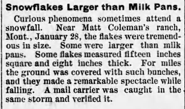
1969: Heavy rains of tropical origin that began on 1/18 ended on this day. As much as 50 inches of rain fell at 7,700 feet. 31 inches of rain fell on the south slopes of Mt. San Gorgonio, 15.5 inches at San Jacinto Peak, around ten inches at Banning, less than one inch from Indio southeast. 91 were reported dead from flooding and mudslides all over California and state-wide.

The image above is from a tweet by the NWS Office in San Diego, California.
1977: The Blizzard of '77 was one of the worst winter storms to hit southern Ontario and upstate New York. With the rapid onset of the storm, about 2,000 students in the Niagara region were stranded overnight in schools. Click HERE for more information from Gray Roots and Museum.
1986: The Space Shuttle Challenger broke apart at 11:39 am EST, 73 seconds after liftoff from the Kennedy Space Center at Cape Canaveral, Florida, on a frigid morning. Starting in the 20s, the ground temperature at liftoff was 36 degrees. Morton Thiokol recommended not launching if the liftoff temperature was below 53 degrees. The cold was blamed for causing the O-rings on the Shuttle's external booster to fail, leading to the explosion. Low-level wind shear also played a factor. Click HERE for more information from the History Channel.
Click HERE for more This Day in Weather History from the Southeast Regional Climate Center.


 Follow us on YouTube