Weather History - November 20th
Local and Regional Events:
November 20, 1975:
A storm center located in Oklahoma on Tuesday, November 18th, moved northeastward across Kansas into Iowa and Wisconsin on Wednesday the 19th and Thursday the 20th. Light rain began in the eastern half South Dakota on the morning of the 19th. The rain changed to snow during the afternoon and continued through the evening of the 20th. The winds increased, and blizzard conditions were reached by 6 pm CST on Wednesday the 19th. The snow was driven by sustained winds 40 to 50 miles per hour, gusting to 75 mph on some occasions, which reduced visibility to less than one-half mile. Heavy snow ranging from six to fifteen inches fell over an area southeast of a line from Todd to Aurora to Grant County. Traffic came to a standstill by Wednesday evening the 19th. The snow abruptly ended on the night of the 20th, but winds diminished rather slowly that night. Storm total snowfalls included 9 inches at Clear Lake and 7 inches at Watertown.
November 20, 1977:
The second blizzard of the month began very early on Saturday, November 19th and continued through most of Sunday, November 20th. Wind speeds exceeding 50 mph caused much blowing and drifting snow. Visibility was reduced to near zero. Most of the roads in the northern and western parts of the state were blocked. Snowfall amounts north of Milbank and Pierre to Ardmore exceeded five inches. Most of the counties in the northwest and a significant portion of those in the north-central parts of the state reported snowfall amounts exceeding ten inches. Some drifts reached 4 to 5 feet. The highest reported snowfall was 20 inches in Eagle Butte. An eastbound train from Milbank had six freight cars derailed near Albee, in Grant County as a result of the storm. Snowfall totals from this blizzard included; 20 inches at Eagle Butte; 14 inches at Leola; 12 inches at Timber Lake and Britton; 11 inches 4NNE Victor and at Mobridge; 10 inches at 6SE McIntosh, 4W Mellette, Sand Lake, and Ipswich; 9.3 inches in Aberdeen; 9 inches 4NW Onida, at Sisseton, and 2N Onaka; 8 inches at Selby; 7 inches at McLaughlin and Waubay; 6 inches at Conde and Faulkton; 5 inches at Summit and Webster; 4 inches at Pierre, Wilmot and Highmore; and 3 inches at Watertown, Clear Lake, Miller, 3NE Raymond, Redfield, and Wheaton. The 9 inches at Sisseton helped to contribute to the snowiest November on record for Sisseton, which recorded 27.5 inches for November 1977.
U.S.A and Global Events for November 20th:
1900: An unusual tornado outbreak in the Lower Mississippi Valley resulted in 73 deaths and extensive damage across Arkansas, Mississippi, and Tennessee.
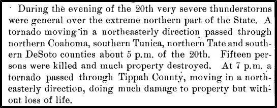
The clipping above is from the Climatological Data Publications for the state of Mississippi in November 1900.
1985: Kate intensified to a major Category 3 Hurricane and as she moved west of Key West, Florida with top winds of 115 mph and a minimum central pressure of 954 millibars or 28.17 inches of mercury. The next day Kate made landfall between Panama City and Apalachicola, Florida. Tides ran 8 to 10 feet above normal. Many power poles and lines were downed. Several roads were washed out.

Hurricane Kate from NOAA 9 on November 20, 1985.

Credit this photo: State Archives of Florida, Florida Memory, https://floridamemory.com/items/show/14095 Members of Florida State's Delta Tau Delta fraternity had a difficult time getting to their cars following Hurricane Kate's visit to the capital city.
2014: From the NWS Office in Buffalo, New York, “the epic November 17-19th 2014 lake effect event will be remembered as one of the most significant winter events in Buffalo’s snowy history. Over 5 feet of snow fell over areas just east of Buffalo, with mere inches a few miles away to the north. There were 13 fatalities with this storm, hundreds of major roof collapses and structural failures, 1000s of stranded motorists, and scattered food and gas shortages due to impassable roads. Numerous trees also gave way due to the weight of the snow, causing isolated power outages. While this storm was impressive on its own, a second lake effect event on Nov-19-20 dropped another 1-4 foot of snow over nearly the same area and compounded rescue and recovery efforts. Storm totals from the two storms peaked at almost 7 feet, with many areas buried under 3-4 feet of dense snowpack by the end of the event.” Click HERE for more information. Click HERE for photos from Syracuse.com
2015: Season's first snow is Chicago's largest November snowfall in 120 years starting on November 20 and ending on the 21st. The season's first snowfall dropped as much as 17 inches across Chicago's northern suburbs, and the total of 11.2 inches at O'Hare International Airport made it the largest November snowfall in 120 years. Click HERE for more information from the NWS Office in Chicago.
Click HERE for more This Day in Weather History from the Southeast Regional Climate Center.


 Follow us on YouTube