Local and Regional Events:
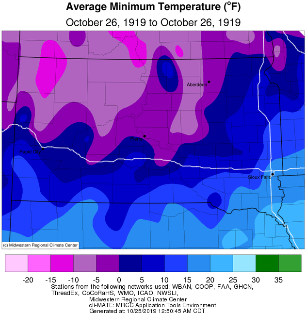
October 26, 1919:
Record cold occurred across the area on this day in 1919. Temperatures fell below zero at many locations across central and northeast South Dakota and into west-central Minnesota. The record lows were 3 degrees below zero at Aberdeen, 4 degrees below zero at Wheaton, 5 degrees below zero at Kennebec, 8 degrees below zero at McIntosh, and a much below average low of 10 degrees below zero at Miller.
October 26, 1996:
A rare and significant late-season tornado outbreak took place as a low-pressure system trekked across the North-Central US. A series of low-topped supercells during the morning and afternoon hours produced a total of 26 tornadoes; 3 in Nebraska, 9 in northeastern South Dakota, and 14 across west-central and central Minnesota. Five of these were rated F2, and while no fatalities resulted, 15 people were injured, and there was a good deal of property damage. To help put the extraordinary timing of this event in perspective, in the 66 years of record-keeping from 1950-2015, Minnesota has only recorded 15 other October tornadoes, and South Dakota 9.
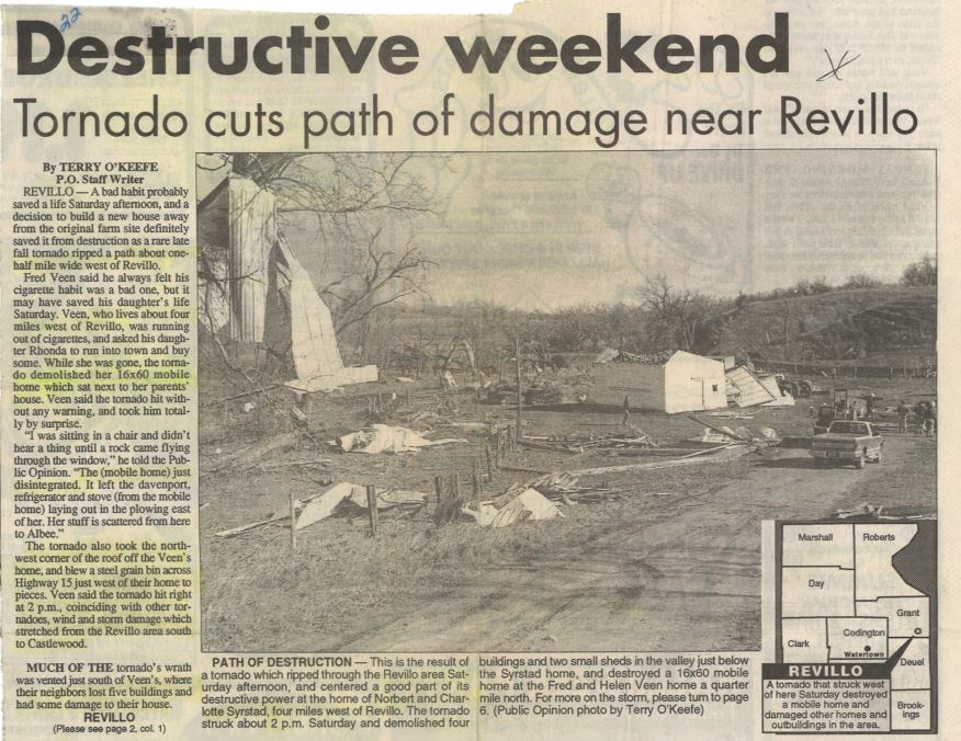
The image above is courtesy of the Watertown Public Opinion.
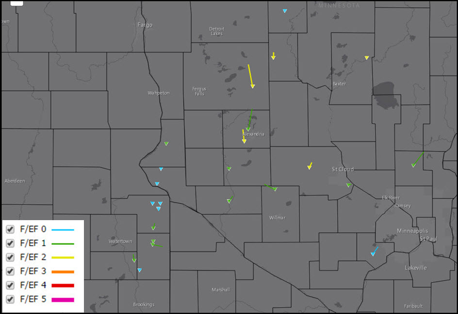
The tornado track map above is courtesy of the Midwestern Regional Climate Center.
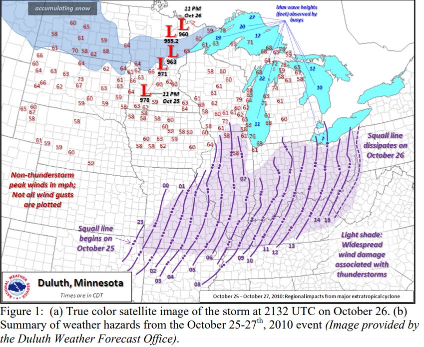
October 26, 2010:
A record-breaking surface low-pressure area moved across the Northern Plains and brought high winds to all of central and northeast South Dakota from the early morning of the 26th into the early evening of the 27th. Big Fork, Minnesota, measured a surface low pressure of 955.2 millibars. Sustained northwest winds of 40 to 50 mph with gusts to 60 to 75 mph caused scattered property damage across the region along with blowing several vehicles off the road. Along with the high winds came snowfall of 1 to 5 inches, which resulted in treacherous driving conditions. Several schools started late on the 27th due to the slippery roads and strong winds. The high winds, combined with slick roads at times, blew several semis and other vehicles off the road on Interstate-29 and other locations across the region. Only minor injuries occurred with these incidents. The high winds damaged many traffic signs and signals, downed many power lines and poles, along with downing branches and several trees. As a result, several hundred customers were without power for a time across the area. The high winds caused roof and siding damage to many buildings along with damaging some fences. A shed was also destroyed near Sisseton. Click HERE for more information from the Weather Prediction Center.

The image above is the true-color satellite image of the storm at 2132 UTC on October 26th, 2010.
U.S.A and Global Events for October 26th:
1865: A hurricane sank the steamship USS Mobile off the Georgia coast. The wreck, laden with 20,000 gold coins, was found in 2003. Click HERE for more information from the Odyssey's Virtual Museum.
1952: There have been thousands of weather reconnaissance and research flights into hurricanes in the Atlantic and Pacific since the mid-1940s. There have been several close calls, but only four flights have been lost. A B-29 Super-fortress flight into Super Typhoon Wilma 350 miles east of Leyte in the Philippines disappeared on this date. No trace was ever found of the plane or crew. In the last report, the flight was in the Super typhoon's strongest winds, which were around 160 mph.

1997: An autumn snowstorm pummeled central and south-central Nebraska with record early season snows. Wind-driven snowfall amounts totaled as much as two feet by storms' end. Several highways were closed, including Interstate 80, as near-blizzard conditions developed. Once the snow subsided, the record early season snow totals were tallied. Guide Rock measured twenty-four inches of snow, Clay Center twenty-three inches, and Hastings seventeen inches. A fifty-mile wide swath of snow more than fifteen inches fell from near Alma to York. Amounts further north averaged from four to eight inches. The heavy, wet snow was responsible for many power outages in the area as tree limbs broke and fell on power lines. At one point, the town of Hardy had no power and could not be accessed by vehicles due to the snow. Numerous schools and businesses remained closed several days following the storm. Many highways, including Interstate 80, closed at the height of the storm. On Highway 136 east of Alma, road crews worked for ten hours carving through a ten-foot drift that covered the road. Record cold accompanied the snow as temperatures dropped to the single digits on the morning of the 26th.
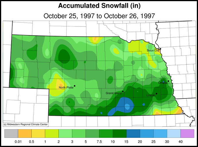
The snowfall map above is courtesy of the Midwestern Regional Climate Center.
1998: Hurricane Mitch, the second deadliest hurricane in the Atlantic Ocean, reached Category 5 strength on this day.

The image above is courtesy of NOAA.
Click HERE for more This Day in Weather History from the Southeast Regional Climate Center.


 Follow us on YouTube