Have you ever wondered how some of the winter storms you have experienced in your lifetime compare to the most extreme storms in South Dakota history? We have used a special ranking system called the Local Winter Storm Scale (LWSS) to try to do just that. Ranking winter storms is not an easy task, especially when it comes to very old events when modern equipment was not available to accurately measure wind speed, visibility, etc. Because of these data quality limitations, we restricted our analysis to the period 1950-2012. We also know that weather can be highly variable from one location to another. For instance, while Mobridge may have experienced a storm of catastrophic proportions, Watertown may have only experienced light to moderate snow. To account for this variability, we have evaluated the top five worst storms broken out between regions of the NWS Aberdeen forecast area: Mobridge, Pierre, Aberdeen and Watertown.
Here is a brief description of how the Local Winter Storm Scale works to rank a storm:
The Local Winter Storm Scale (LWSS) is a means to rank winter storms in a "semi-objective" fashion using five weather elements frequently found to describe the potential impact (disruption and destruction) of winter storms and blizzards. The five elements are listed below:
The LWSS scale computes a numerical value from 0 (nuisance) to 6 (catastrophic). Also keep in mind that the LWSS does not include several other factors that can be important societal impacts during winter storms including:
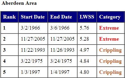
ABERDEEN
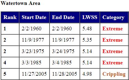
WATERTOWN
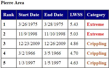
PIERRE
MOBRIDGE
Below is a list of additional winter storms that impacted the entire state of South Dakota.


 Follow us on YouTube