 |
 |
 |
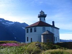
Alaska's capital city, is in the Panhandle region of the state. The Southeast Alaska Panhandle is approximately 500 miles long by 120 miles wide and consists of a narrow mainland strip of steep mountains, ice fields, and glaciers along with several thousand islands that make up the Alexander Archipelago. Seventy-seven percent of the Panhandle is the 17-million acre Tongass National Forest; a temperate rainforest of Sitka spruce, western hemlock, blueberries, salmon berries, ferns, and skunk cabbage.
Temperate means the area is in the mid-latitudes, and rainforest generally means that it is a forest that grows in a region of heavy annual precipitation. That number varies widely over the Panhandle with the northern town of Skagway averaging around 18 inches per year while some areas over the southern end of Baranof Island average around 150 inches per year. Juneau averages around 54 inches annually at the airport, but over 90 inches downtown. Most of the precipitation comes in the fall and winter with the "dry season" normally in late spring and early summer.
June, July, and August are the warmest months of the year with average daily highs creeping above 60 degrees...peaking in July with an average max of 63.8. July is also the month Juneau set its all-time high temperature of 90 degrees on July 7, 1975.
Juneau is located along Gastineau Channel in the Inside Passage about 900 miles north of Seattle and 600 miles southeast of Anchorage. There are no roads leading into or out of town, so all travelers come by air or water. In the summer, commercial air carriers offer numerous flights per day into and out of town, while the Alaska Marine Highway ferries make frequent trips north and south with passengers and cars. Juneau is the third largest city in the state, after Anchorage and Fairbanks, with a population of around 30,000. The local economy is based mainly on state, local, and federal government, tourism, mining, and fishing.
Southeast Alaska does not have the "midnight sun" experienced like further north in Alaska, but day length is much longer in the summer and much shorter in the winter compared to the "lower 48". At the summer solstice daylight in Juneau lasts for 18 hours and 18 minutes, while at winter solstice the sun is up for only 6 hours and 21 minutes.
Below is a map containing weather data from various cities in Southeast Alaska. The locations were selected in an effort to provide a representation of the climatic variation across Southeast Alaska caused by its complex terrain and does not contain records broken after 2010.
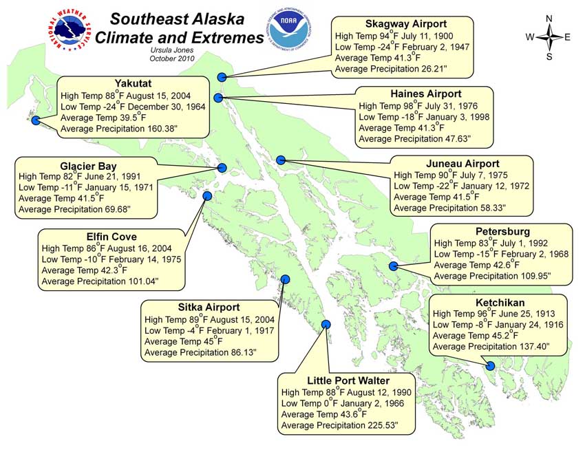
All of the average temperatures and precipitation data were taken from the National Center for Environmental Information (previously NCDC), the official source for climate data for the National Weather Service. The high and low temperature was taken from WFO Juneau's Alaska Climatology database.
Population estimates for Southeast cites differ from a little over 30,000 in Juneau to less than 100 in Tenakee Springs. Here are some estimates for towns around Southeast.
|
|
|
| Angoon | 445 |
| Craig | 1,171 |
| Gustavus | 355 |
| Haines | 2,399 |
| Hoonah | 715 |
| Juneau | 30,988 |
| Kake | 635 |
| Ketchikan | 7,280 |
| Klawock | 736 |
| Petersburg | 2,825 |
| Sitka | 8,889 |
| Skagway | 892 |
| Tenakee Springs | 91 |
| Wrangell | 1,990 |
| Yakutat | 685 |
Outdoor Activities
If you enjoy the outdoors, the Juneau area has numerous trails for different level of hikers. There are several, easily accessible walks in the Juneau area as well as more challenging hikes.
The Mendenhall Glacier is located 12 miles from downtown Juneau and 5 miles from the Juneau Airport. There are six distinct trails located near the Glacier. Three of them are relatively easy walking and they include: Photo Point trail, Trail of Time, and Moraine Ecology trail. If you are unfamiliar with the Juneau area, stop at the Glacier Visitor Center for information on the types of animals to watch for and what time of year is best to hike certain trails. More difficult trails near the Glacier are East Glacier Loop and West Glacier trail. These trails are considered more difficult because of their length.
Come prepared for inclement weather by wearing clothing that is warm even when wet, like wool and polar fleece. Layering is also important in all seasons. Use a shirt as a first layer, a sweatshirt for a second layer, and top it all off with a waterproof hooded jacket. Raingear, hats, gloves and sturdy shoes or hiking boots are strongly recommended. Juneau's weather is fairly mild due to it's marine location. Summer highs hover in the upper sixties and summer lows drop to the mid-fifties. Winter highs reach to 45°F and winter lows stray into the mid-twenties. Remember to bring shorts or short-sleeve shirts for warmer weather.
The Mount Roberts Tramway provides excellent views of Gastineau Channel and the mountains. After riding up the enclosed tramway gondola, enjoy viewing the Seeing Daylight film in the Chilkat Theater to learn about the Tlingit culture. There are several Native and historical artwork displayed in and around the Mount Roberts Tram complex.
Other activities enjoyed by Southeast Alaska residents are skiing, boating, skating, helicopter tours as well as whale watching tours. One popular annual event is the Alaska Folk Festival. Beginning in 1975, the Alaska Folk Festival has grown from its humble beginning of eight musicians playing one evening, to over 50 performers providing entertainment over nine days. With dances, workshops, special events, and concerts, the Alaska Folk Festival is a must-see event when you live in Juneau.
Locals Schools
The Juneau School District is home to approximately 5,000 public school students. The District has six elementary schools; two mid-sized middle schools, two medium sized high schools, an alternative high school and a K-8 Charter School. Other District programs include Montessori, home school, and a Tlingit Culture, Language and Literacy program. One in four of the district's students are of Alaska Native heritage.
The University of Alaska Southeast, also known as UAS, is a public, regional institute under the University of Alaska System. The main campus is located in the Auke Bay area of Juneau. UAS also has two other campuses in Ketchikan and Sitka. More than 2,000 students enroll in this university.
University of Alaska Southeast offers a wide variety of bachelor degrees, master degrees, and graduate certificate programs through the following academic divisions:
Students of UAS participate in a number of intramural sports including basketball, racquetball, riflery, skiing, tennis, softball, volleyball, and ultimate Frisbee.
 |
Welcome to WFO Juneau | NWS History | Operations | Forecast Products | Local Area Information |  |
| Marine Forecast | Fire Weather | Hydrology | Satellites |

