Overview
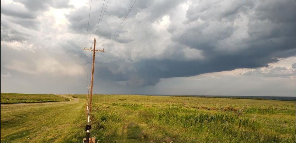
A compact upper level disturbance and weak frontal boundary supported storm development in what turned out to be a weakly capped environment. Moderate instability and shear supported a few high based supercell structures which moved southeast from near Dalhart all the way down to Wellington. Very large hail, strong winds and a few funnels were reported with these storms. The largest hail was reported in Pampa (slightly larger than baseballs), and the strongest wind was reported in Borger (86 mph). Wind damage was also reported in Borger and Wellington. A more isolated storm also formed near Canyon which produced some hail up to ping pong ball size. A brief land spout tornado also occurred west southwest of Pampa.
Photos & Video
 |
 |
 |
|
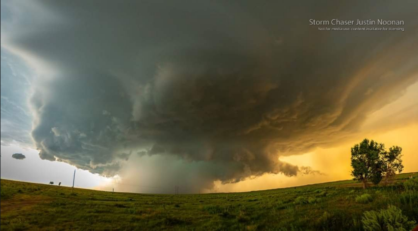
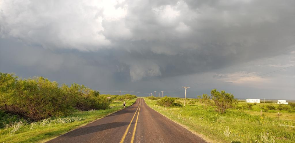
| Large supercell near Borger, tX (Photo Credit: Justin Noonan) |
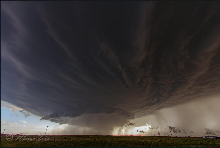
Supercell near Lake Merideth (Photo Credit: Marcus Diaz) |
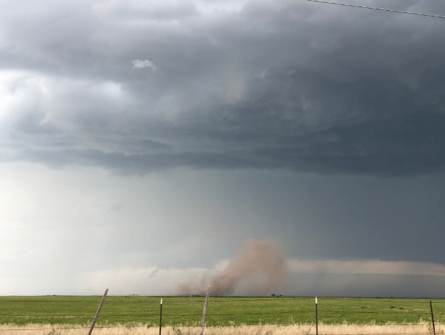
Rear Flank Downdraft kicking up dust beneath updraft base (Photo Credit: Aaron Graves) |
 |
 |
 |
|
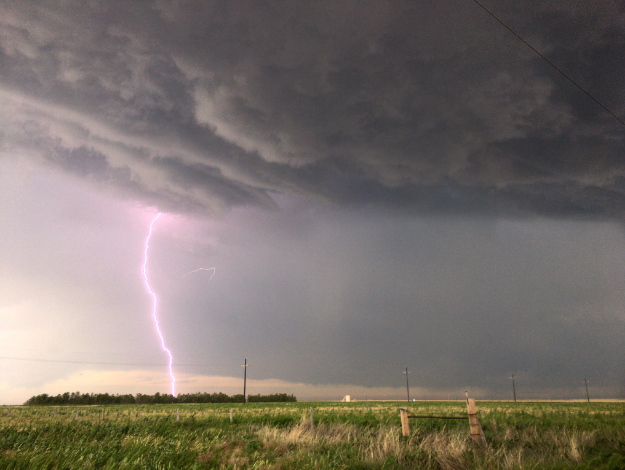
| Cloud to ground lightning near Dalhart, TX (Photo Credit: Aaron Graves) |
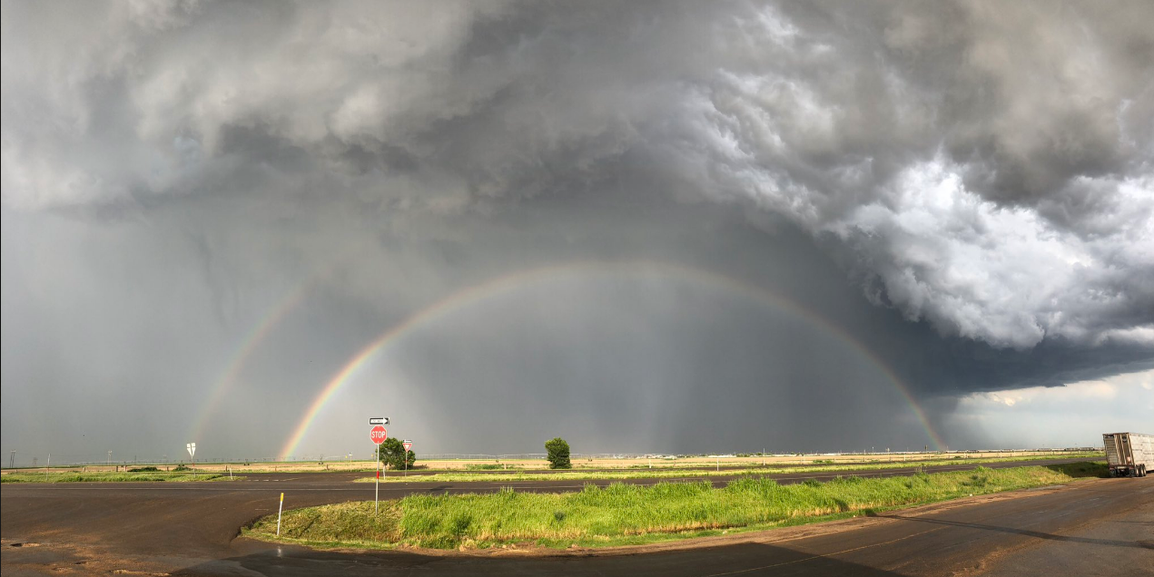
Rainbow East of Dalhart, TX (Photo Credit: Aaron Graves) |
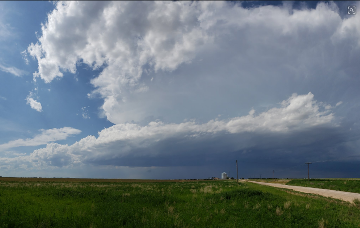
Cumulonimbus with visible rain-free base NW of Dalhart, TX (Photo Credit: Jeff Frame) |
 |
 |
 |
|
| Rotating wall cloud east of Fritch, TX (Photo Credit: Jeff Frame) |
Wall cloud east of Fritch (Photo Credit: Jeff Frame) |
1.5" hail in Canyon, TX (Photo Credit: Jami Cowart) |
Storm Reports
PRELIMINARY LOCAL STORM REPORT...SUMMARY
NATIONAL WEATHER SERVICE AMARILLO TX
248 PM CDT WED JUN 19 2019
..TIME... ...EVENT... ...CITY LOCATION... ...LAT.LON...
..DATE... ....MAG.... ..COUNTY LOCATION..ST.. ...SOURCE....
..REMARKS..
0412 PM HAIL 5 SW STRATFORD 36.29N 102.14W
06/18/2019 E1.00 INCH SHERMAN TX STORM CHASER
0434 PM HAIL 4 ESE STRATFORD 36.31N 102.02W
06/18/2019 E1.00 INCH SHERMAN TX PUBLIC
NICKEL AND QUARTER SIZE HAIL.
0553 PM HAIL 1 SW CONLEN 36.23N 102.26W
06/18/2019 M1.25 INCH DALLAM TX PUBLIC
LATE REPORT OF HALF DOLLAR SIZE HAIL ALONG U.S. HIGHWAY
54 NEAR CONLEN. TIME ESTIMATED FROM RADAR.
0608 PM HAIL 14 NW DAWN 35.03N 102.40W
06/18/2019 E1.00 INCH DEAF SMITH TX PUBLIC
LATE REPORT FROM AREA RANCHERS OF DIME TO A FEW QUARTER
SIZE HAIL STONES. TIME ESTIMATED FROM RADAR.
0619 PM HAIL 6 S CONLEN 36.15N 102.24W
06/18/2019 E1.75 INCH DALLAM TX STORM CHASER
0625 PM HAIL 3 S CONLEN 36.19N 102.24W
06/18/2019 E1.00 INCH DALLAM TX STORM CHASER
HAIL FALLING AT TIME OF CALL.
0655 PM HAIL 4 WNW CANYON 35.01N 101.98W
06/18/2019 E1.25 INCH RANDALL TX PUBLIC
0701 PM HAIL 2 N CACTUS 36.07N 102.01W
06/18/2019 M1.50 INCH SHERMAN TX TRAINED SPOTTER
0701 PM HAIL 4 N CANYON 35.04N 101.92W
06/18/2019 M1.00 INCH RANDALL TX SOCIAL MEDIA
LATE REPORT FROM FACEBOOK OF QUARTER SIZE HAIL NORTH OF
CANYON. TIME ESTIMATED FROM RADAR.
0705 PM HAIL 2 W CANYON 34.98N 101.96W
06/18/2019 E2.00 INCH RANDALL TX SOCIAL MEDIA
LATE REPORT: PHOTO OF 2.00" HAIL POSTED ON FACEBOOK.
TIME ESTIMATED BASED ON RADAR.
0707 PM HAIL 2 WNW CANYON 34.99N 101.95W
06/18/2019 M1.25 INCH RANDALL TX NWS EMPLOYEE
0715 PM HAIL 5 SE CACTUS 35.99N 101.95W
06/18/2019 E0.88 INCH MOORE TX TRAINED SPOTTER
PENNY TO NICKEL SIZE HAIL FALLING AT TIME OF REPORT.
0723 PM HAIL 1 SE CACTUS 36.03N 102.00W
06/18/2019 M1.00 INCH MOORE TX TRAINED SPOTTER
0726 PM FUNNEL CLOUD 6 NE DUMAS 35.92N 101.88W
06/18/2019 MOORE TX TRAINED SPOTTER
LARGE FUNNEL CLOUD OBSERVED HALF WAY DOWN TO THE
GROUND.
0727 PM HAIL 3 E CANYON 34.97N 101.87W
06/18/2019 E1.25 INCH RANDALL TX SOCIAL MEDIA
TWITTER PHOTO OF QUARTER TO HALF DOLLAR SIZE HAIL.
0809 PM TSTM WND DMG 2 WSW STINNETT 35.81N 101.47W
06/18/2019 HUTCHINSON TX TRAINED SPOTTER
LATE REPORT OF DAMAGE TO HOUSE ROOF DUE TO 6 INCH TREE
LIMBS BROKEN OFF TREE FROM THUNDERSTORM WINDS. TIME
ESTIMATED FROM RADAR.
0809 PM TSTM WND DMG 1 W SANFORD 35.71N 101.55W
06/18/2019 HUTCHINSON TX LOCAL OFFICIAL
LATE REPORT OF SEVERAL TREE LIMBS 3 TO 6 INCHES IN
DIAMETER DOWNED. TIME ESTIMATED FROM RADAR.
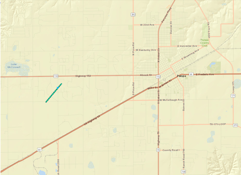
0814 PM TORNADO 2 NW KINGSMILL 35.51N 101.09W
06/18/2019 GRAY TX TRAINED SPOTTER
BRIEF TORNADO WEST OF PAMPA NEAR HIGHWAY 152 REPORTED
BY SEVERAL TRAINED SPOTTERS. TORNADO ON THE GROUND LESS
THAN ONE MINUTE. LOCATION BASED ON RADAR.
0815 PM TSTM WND GST 1 WNW FRITCH 35.65N 101.62W
06/18/2019 M59 MPH MOORE TX MESONET
0815 PM HAIL PAMPA 35.55N 100.96W
06/18/2019 M3.00 INCH GRAY TX PUBLIC
PICTURE OF HAIL SENT VIA SOCIAL MEDIA.
0819 PM HAIL 3 W BORGER 35.65N 101.45W
06/18/2019 E1.75 INCH HUTCHINSON TX PUBLIC
LATE REPORT OF GOLF BALL SIZE HAIL, WITH TIME ESTIMATED
FROM RADAR.
0822 PM HAIL PAMPA 35.55N 100.96W
06/18/2019 E1.80 INCH GRAY TX PUBLIC
HAIL LARGER THAN GOLF BALLS FALLING.
0822 PM TSTM WND GST 4 WSW BORGER 35.64N 101.46W
06/18/2019 E75 MPH HUTCHINSON TX TRAINED SPOTTER
LOOSE OBJECTS TOSSED AROUND AND SMALL TREE BRANCHES
BROKEN. QUARTER SIZE HAIL.
0822 PM HAIL 4 WSW BORGER 35.64N 101.46W
06/18/2019 E1.00 INCH HUTCHINSON TX TRAINED SPOTTER
LOOSE OBJECTS TOSSED AROUND AND SMALL TREE BRANCHES
BROKEN. QUARTER SIZE HAIL.
0825 PM HAIL 5 NNW BORGER 35.73N 101.42W
06/18/2019 M1.75 INCH HUTCHINSON TX BROADCAST MEDIA
LATE REPORT FROM BROADCAST MEDIA METEOROLOGIST OF VIDEO
SHOWING HALF-DOLLAR TO GOLF BALL SIZE HAIL. TIME
ESTIMATED FROM RADAR.
0826 PM TSTM WND GST 2 N BORGER 35.70N 101.40W
06/18/2019 M62 MPH HUTCHINSON TX ASOS
0830 PM HAIL 1 ESE BORGER 35.66N 101.38W
06/18/2019 M1.50 INCH HUTCHINSON TX PUBLIC
PICTURE OF HAIL SENT VIA TWITTER.
0830 PM TSTM WND DMG 3 NE BORGER 35.69N 101.36W
06/18/2019 HUTCHINSON TX TRAINED SPOTTER
LATE REPORT OF TRAILER FLIPPED AT PHILLIPS 66 PLAN
NORTHEAST OF BORGER. TIME ESTIMATED FROM RADAR.
0832 PM HAIL 6 SSE BORGER 35.58N 101.34W
06/18/2019 E1.75 INCH CARSON TX PUBLIC
NICKEL TO GOLFBALL SIZE HAIL AT TIME OF CALL.
0833 PM HAIL 2 NE BORGER 35.68N 101.38W
06/18/2019 E2.00 INCH HUTCHINSON TX TRAINED SPOTTER
0833 PM HAIL 1 SE BORGER 35.65N 101.39W
06/18/2019 E3.00 INCH HUTCHINSON TX PUBLIC
LATE REPORT OF 3 INCH HAIL IN THE KEILLER HEIGHTS
SUBDIVISION OF BORGER. TIME ESTIMATED FROM RADAR.
0835 PM HAIL PAMPA 35.55N 100.96W
06/18/2019 E2.00 INCH GRAY TX PUBLIC
0835 PM TSTM WND DMG 1 ESE BORGER 35.65N 101.39W
06/18/2019 HUTCHINSON TX EMERGENCY MNGR
EMERGENCY MANAGER REPORTED ROOF BLOWN OFF HOUSE AND
POWER POLES DOWN.
0835 PM TSTM WND GST 1 ESE BORGER 35.65N 101.38W
06/18/2019 M86 MPH HUTCHINSON TX EMERGENCY MNGR
EMERGENCY MANAGER REPORTED DAVIS MESONET WIND GUSTS OF
86 MPH.
0841 PM TSTM WND GST 8 WNW CODMAN 35.67N 100.88W
06/18/2019 E65 MPH ROBERTS TX TRAINED SPOTTER
LATE REPORT OF STRONG WIND GUSTS ESTIMATED TO BE 60 TO
65 MPH.
0846 PM HAIL 2 SSE PAMPA 35.52N 100.95W
06/18/2019 M2.25 INCH GRAY TX SOCIAL MEDIA
LATE REPORT ON LOCAL BROADCAST MEDIA WEBPAGE OF 2.25
INCH HAIL ON THE SOUTHEAST SIDE OF PAMPA. TIME ESTIMATED
FROM RADAR.
0902 PM HAIL SKELLYTOWN 35.57N 101.17W
06/18/2019 E1.75 INCH CARSON TX TRAINED SPOTTER
0922 PM TSTM WND GST 9 SE WHITE DEER 35.34N 101.07W
06/18/2019 M61 MPH GRAY TX BROADCAST MEDIA
LAZY H FARMS SCHOOLNET
0924 PM TSTM WND GST 9 NE GROOM 35.31N 101.01W
06/18/2019 M69 MPH GRAY TX BROADCAST MEDIA
GRANDVIEW-HOPKINS ABC7 SCHOOLNET SITE
0925 PM TSTM WND DMG 8 NW LAKE MCCLELLAN 35.30N 100.98W
06/18/2019 GRAY TX TRAINED SPOTTER
TRAINED SPOTTER REPORTED SEVERAL POWER POLES DOWN.
0944 PM TSTM WND GST 2 NW LAKE MCCLELLAN 35.24N 100.90W
06/18/2019 M64 MPH GRAY TX MESONET
1005 PM TSTM WND GST 1 SSW BEAVER 36.80N 100.53W
06/18/2019 M64 MPH BEAVER OK MESONET
1032 PM TSTM WND DMG 3 NNW LOGAN 36.62N 100.24W
06/18/2019 BEAVER OK PUBLIC
1-INCH TREE LIMBS BROKEN AND SHINGLES BLOWN OFF ROOF.
1039 PM HAIL DOZIER 35.08N 100.35W
06/18/2019 E1.00 INCH COLLINGSWORTH TX TRAINED SPOTTER
1115 PM TSTM WND DMG 1 ENE WELLINGTON 34.86N 100.20W
06/18/2019 COLLINGSWORTH TX LOCAL OFFICIAL
ROOF BLOWN OFF OF BUILDING, DOWNING POWERLINES.
1153 PM HAIL 7 N WELLINGTON 34.95N 100.21W
06/18/2019 M1.00 INCH COLLINGSWORTH TX TRAINED SPOTTER
OCCURRED ON HIGHWAY 83 NORTH OF WELLINGTON AND WAS
ONGOING AT THE TIME OF THE CALL.
&&
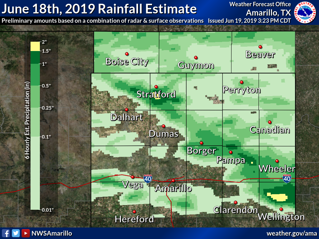
Rain Reports
|
Tornado - West southwest of Pampa, TX
Track Map
|
||||||||||||||||
The Enhanced Fujita (EF) Scale classifies tornadoes into the following categories:
| EF0 Weak 65-85 mph |
EF1 Moderate 86-110 mph |
EF2 Significant 111-135 mph |
EF3 Severe 136-165 mph |
EF4 Extreme 166-200 mph |
EF5 Catastrophic 200+ mph |
 |
|||||
 |
Media use of NWS Web News Stories is encouraged! Please acknowledge the NWS as the source of any news information accessed from this site. |
|