Overview
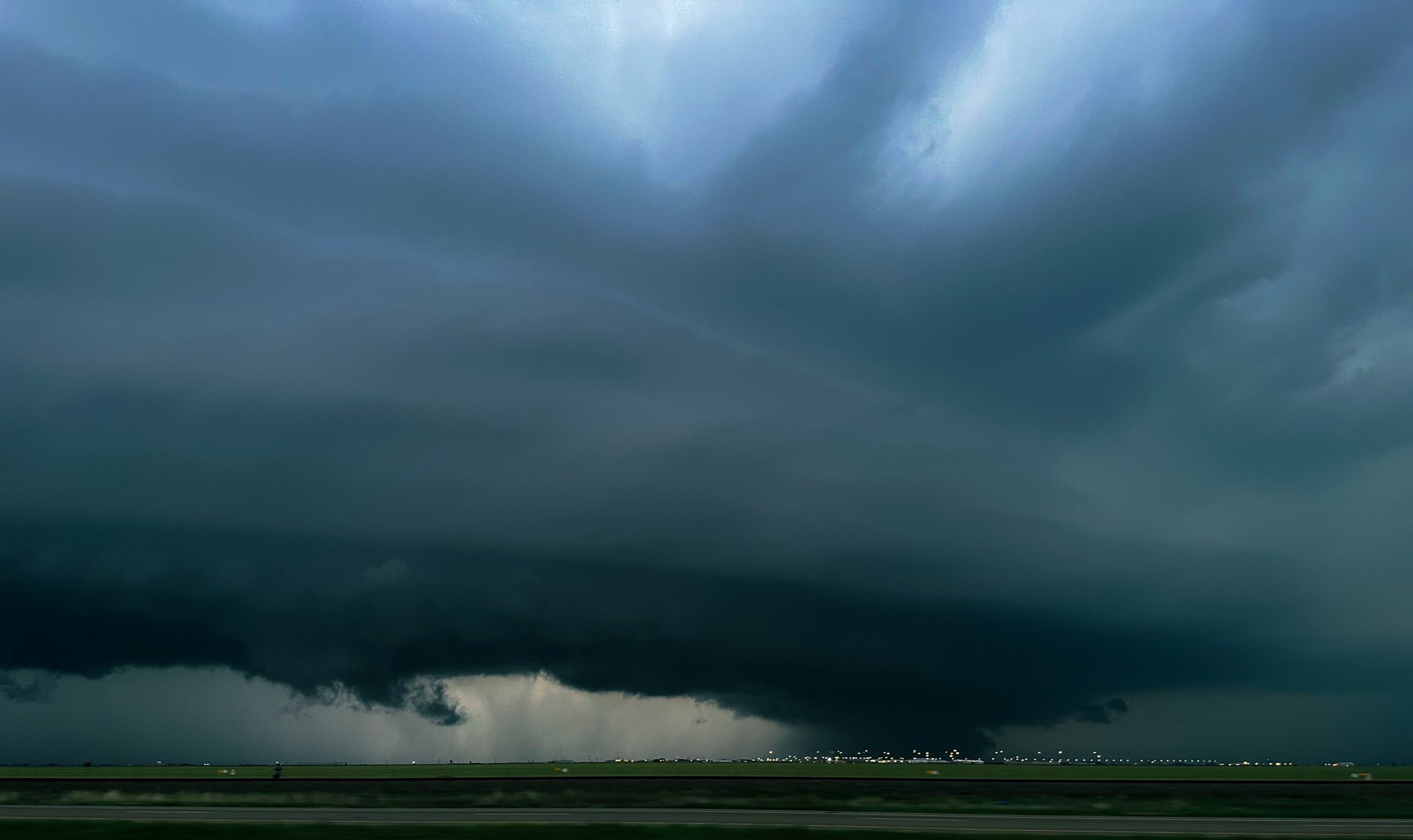
An upper level storm system combined with ample moisture, instability, and surface lift in the vicinity of a diffuse boundary to produce severe thunderstorms across portions of the Texas and Oklahoma Panhandles during the afternoon and overnight period of May 18th into May 19th. The atmospheric moisture was well above normal which lead to very heavy rainfall rates in the stronger storms, some of which exceeded 4 to 6 inches per hour. This led to some flash flooding and river flooding. Some storms also produced large hail up to tennis ball size along with very strong winds associated with supercell rear flank downdrafts. Finally, one very brief tornado was confirmed in Carson County.
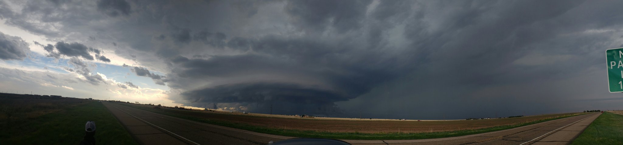
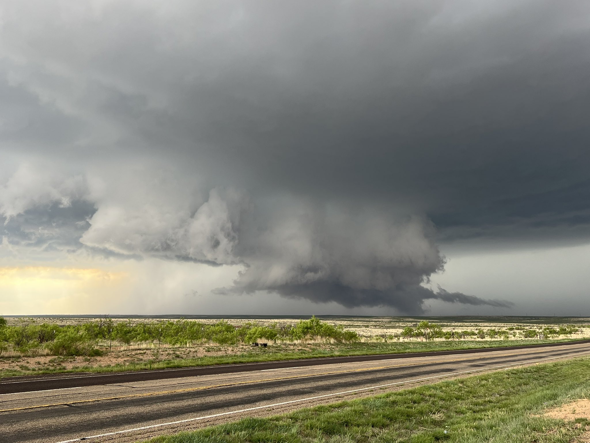
Panoramic image by Luigi Meccariello
|
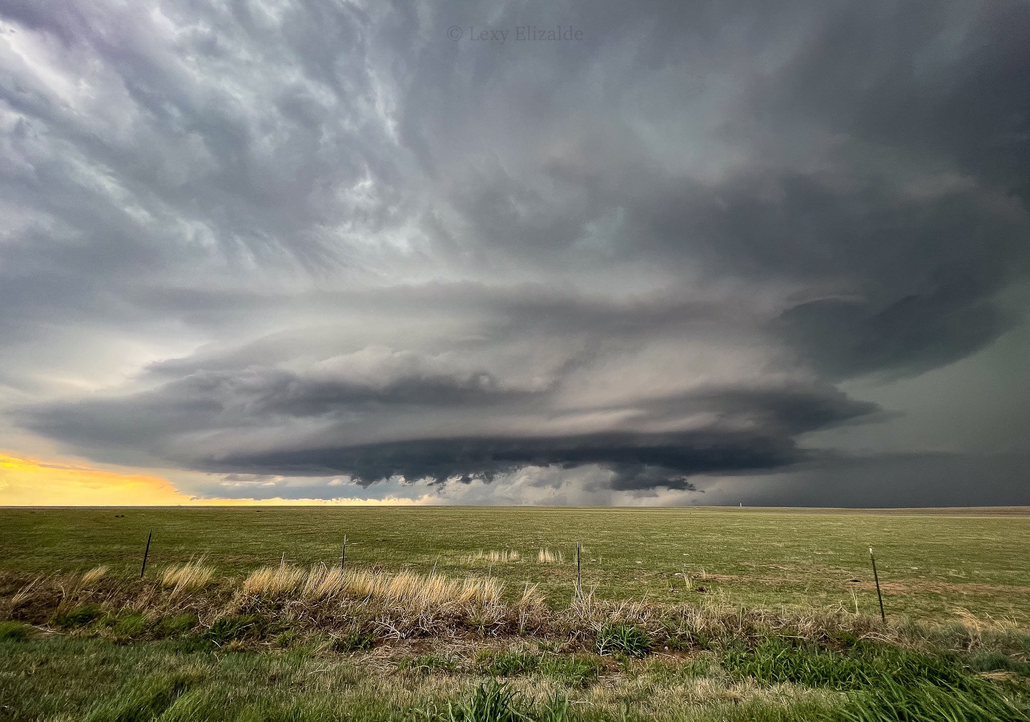
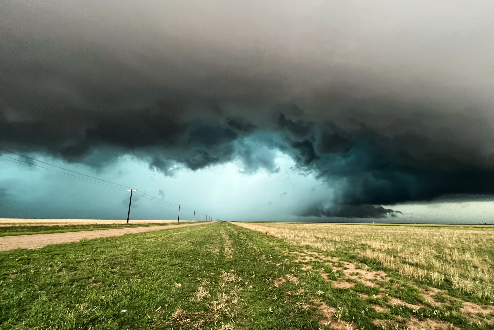
Supercell structure north of Amarillo by Lexy Elizalde |
 Supercell hail core near Stratford, TX by Kyle Cutler |
Tornadoes:
|
Tornado - 4 SSE Pantex
|
||||||||||||||||
The Enhanced Fujita (EF) Scale classifies tornadoes into the following categories:
| EF0 Weak 65-85 mph |
EF1 Moderate 86-110 mph |
EF2 Significant 111-135 mph |
EF3 Severe 136-165 mph |
EF4 Extreme 166-200 mph |
EF5 Catastrophic 200+ mph |
 |
|||||
Wind & Hail:
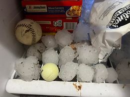
One of the most notable reports was that of wind driven hail near Conlen, TX. This hail ranged in size from nickel to ping pong ball size and was 6 to 8 inches deep once it was over. All the windows on the north side of the homestead were blown out. It was stated that one hailstone flew through a window, through a bedroom, down a hall, and ended up in the next bedroom. Trees were stripped (including bark) and area crops were destroyed.
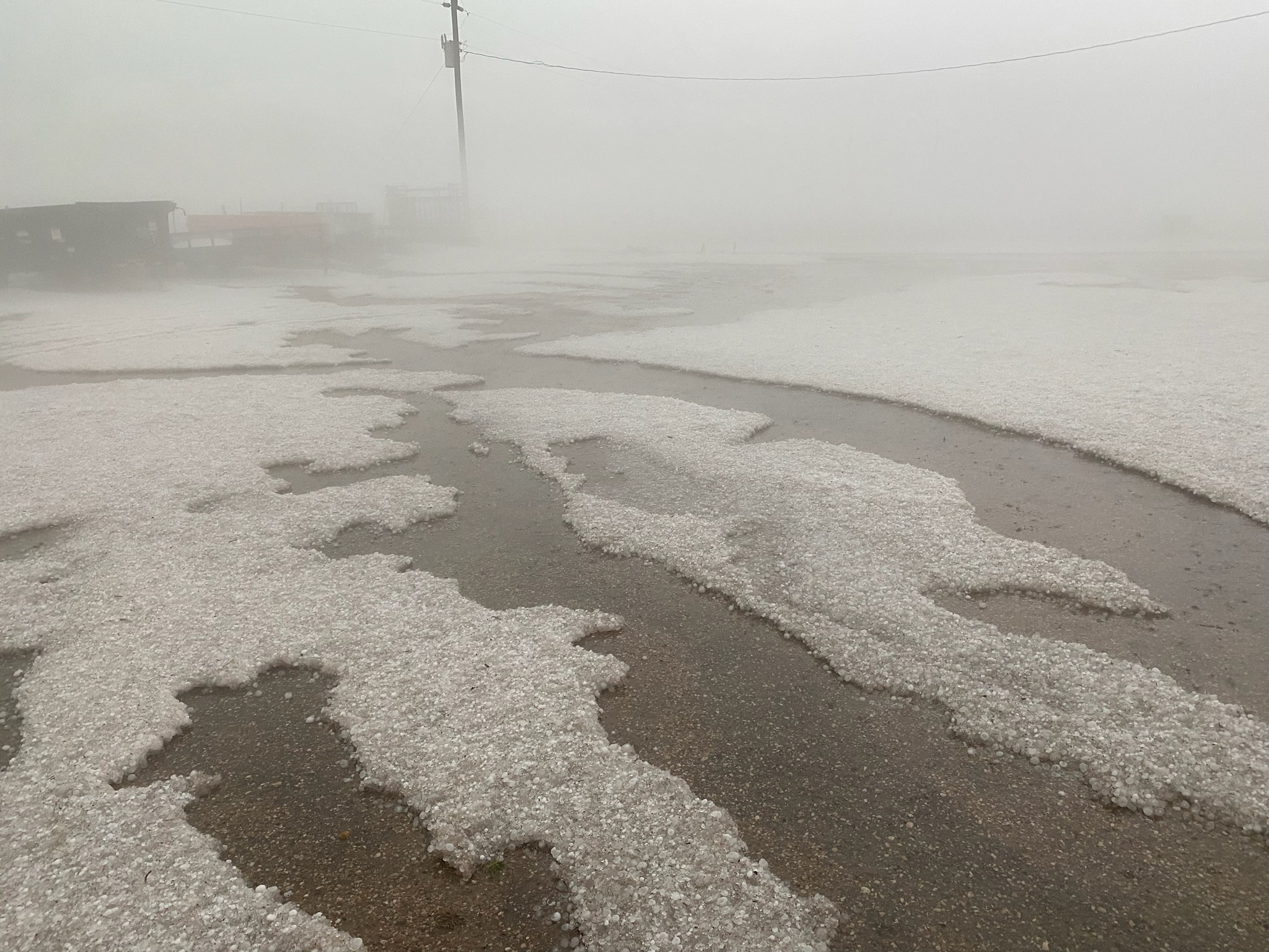
Conlen, TX hail and hail fog.
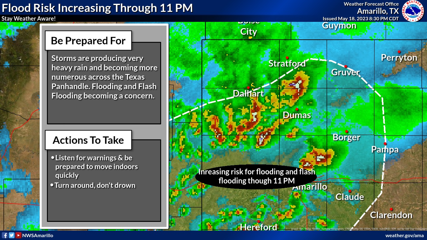
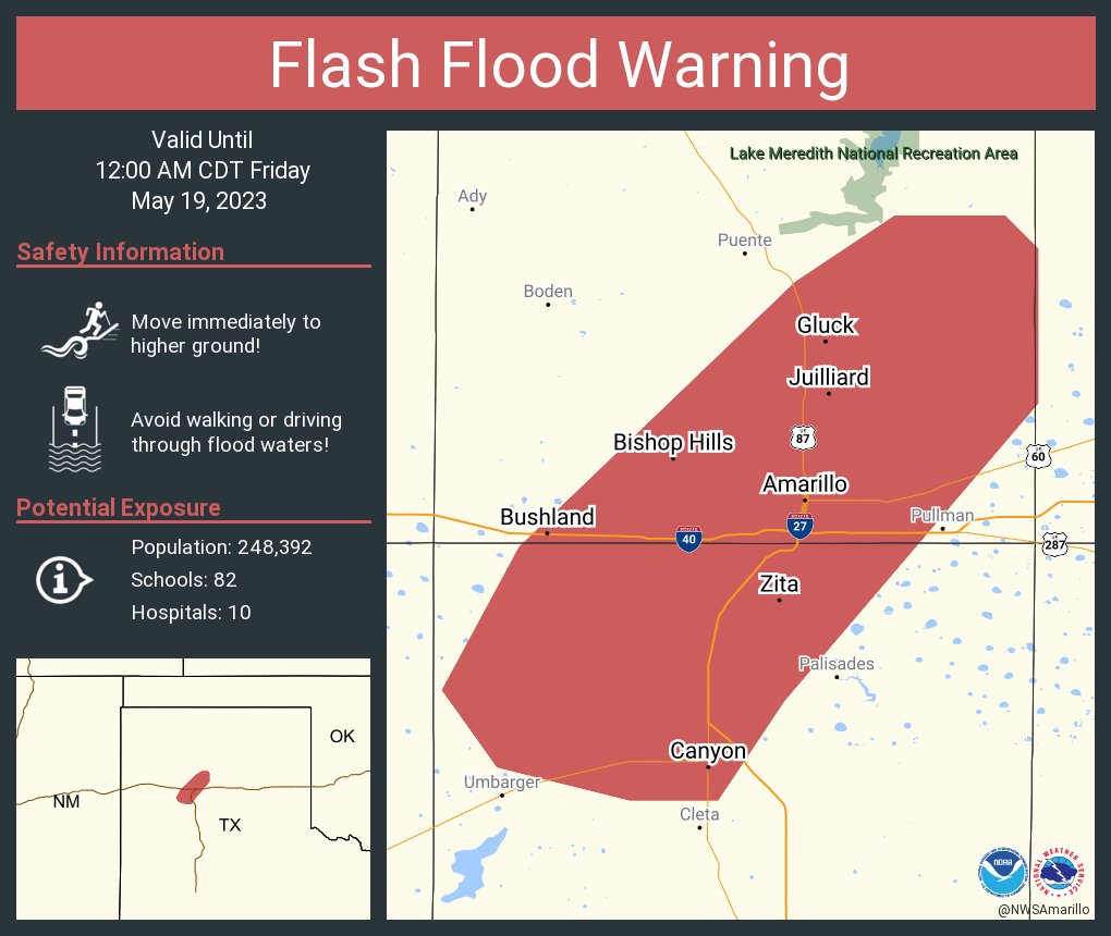
Flooding
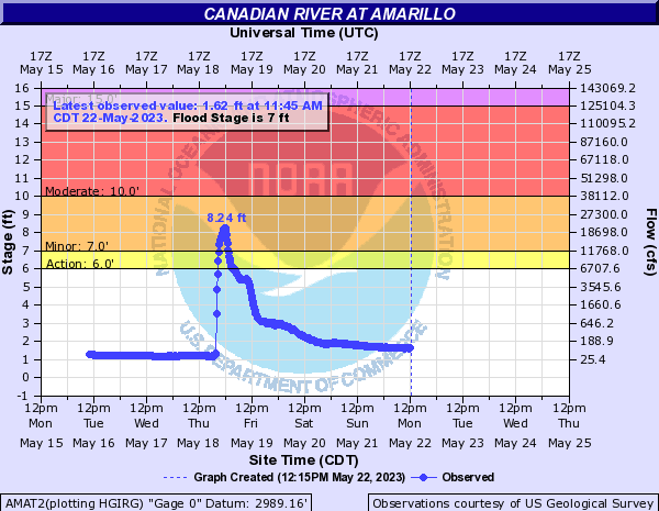
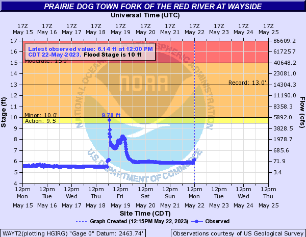
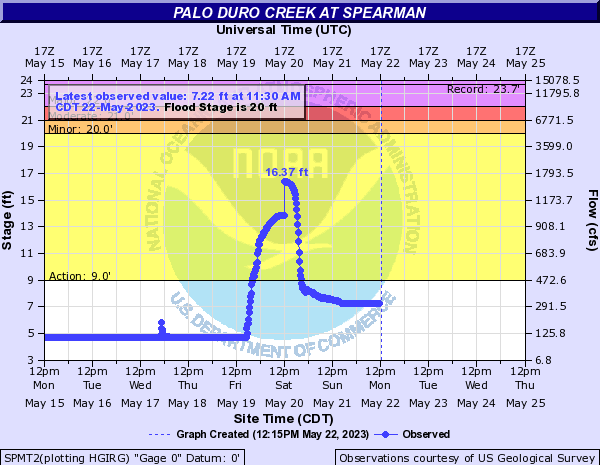
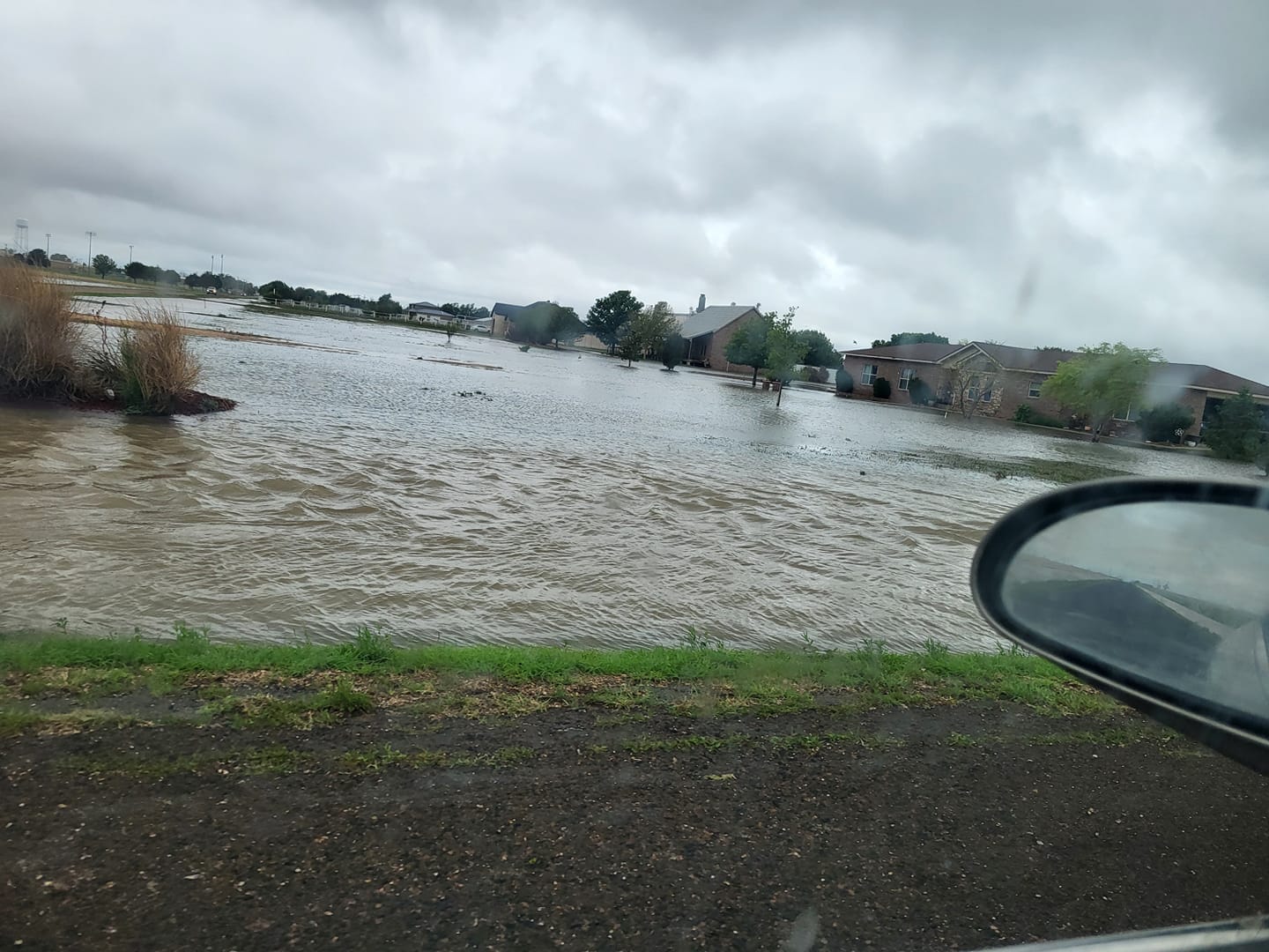
Flash flooding was reported in Amarillo, Sunray, Cactus, Canyon, and in the Palo Duro Canyon State Park. River flooding was also detected among several river flood gauges across the Texas Panhandle through May 19th. The Canadian River 19 miles north of Amarillo at the U.S. Highway 287 bridge hit flood early Friday morning (Friday May 19th, 2023). Impacts included flooding of dirt roads near the river from the bridge downstream to Rosita Creek Flats Recreation Area, where primitive camping occurs. The river crested at 8.24 feet. The last time the river was this high was in August of 1996 when it crested at 7.69 feet. The Prairie Dog Town Fork of the Red River crested right at flood stage Friday morning (5/19/23) from runoff from P.D. Canyon State Park. At 10 feet the river will start to overflow its banks and affect adjacent ranch land. The last time the river was above flood stage was last year on July 30th when it reached a stage of 11.25 feet.
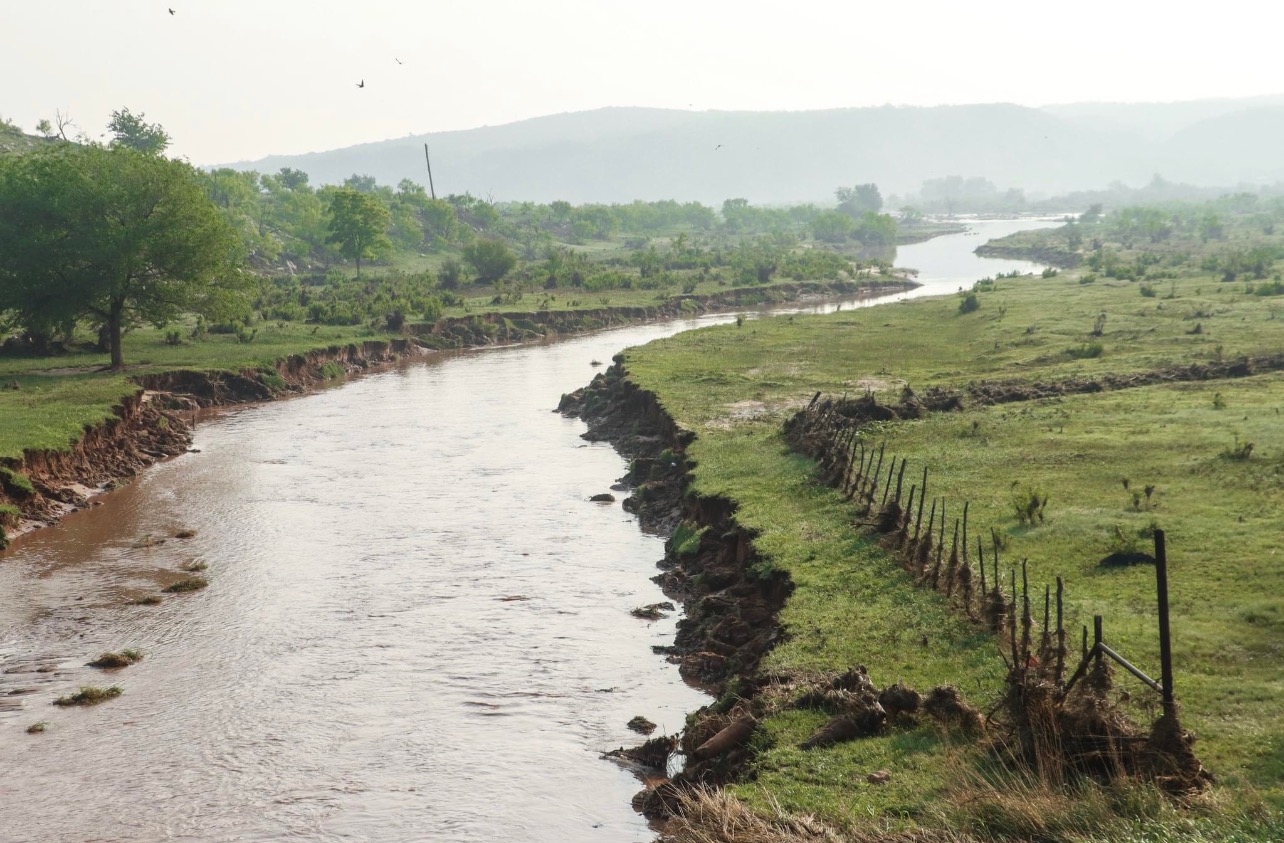
This photo shows the Dixon Creek near Borger which feeds into the Canadian River. After some assessment from land owners in the Dixon creek area east and south of Borger they found numerous fences that washed away. Most of these fences were 4 ft deep and concreted in. The Dixon Creek was approximately 20 ft wide before the rain and now it’s flowing at over 100 ft wide. The land owner stated that the flood completely changed the topography of the creek.
Hydrographs
 |
 |
 |
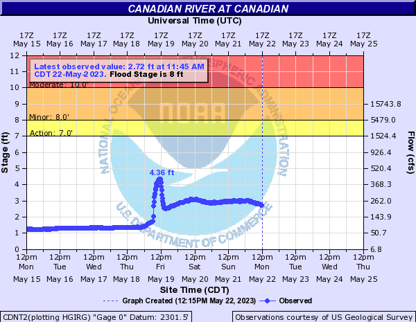 |
| Canadian River 19 N of Amarillo crested at 8.24 feet. Flood stage is 7.0 feet. | Prairie Dog Town Fork of the Red River at Wayside crested at 9.78 feet which is just below flood stage (10.0 ft). | Palo Duro Creek at Spearman crested at 16.37 feet which is below flood stage (20.0 ft). | The Canadian River at Canadian also responded, but stayed below action stage. |
Radar/Photos
 |
 |
 |
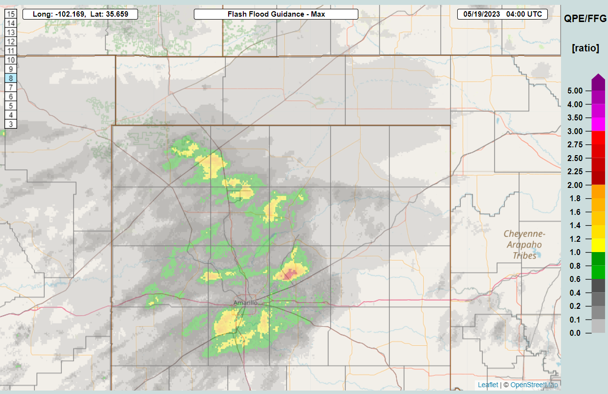 |
| Close up view of rainfall amounts around Amarillo and Canyon. | NowCast posted about 1 hour before Flash Flood Warnings were issued. | Flash Flood Warning issued for the Amarillo/Canyon area as storms began to converge with rainfall rates over 4" per/hr. | The MRMS FLASH QPE/FFG ratio product helped forecasters issue timely flood products. |
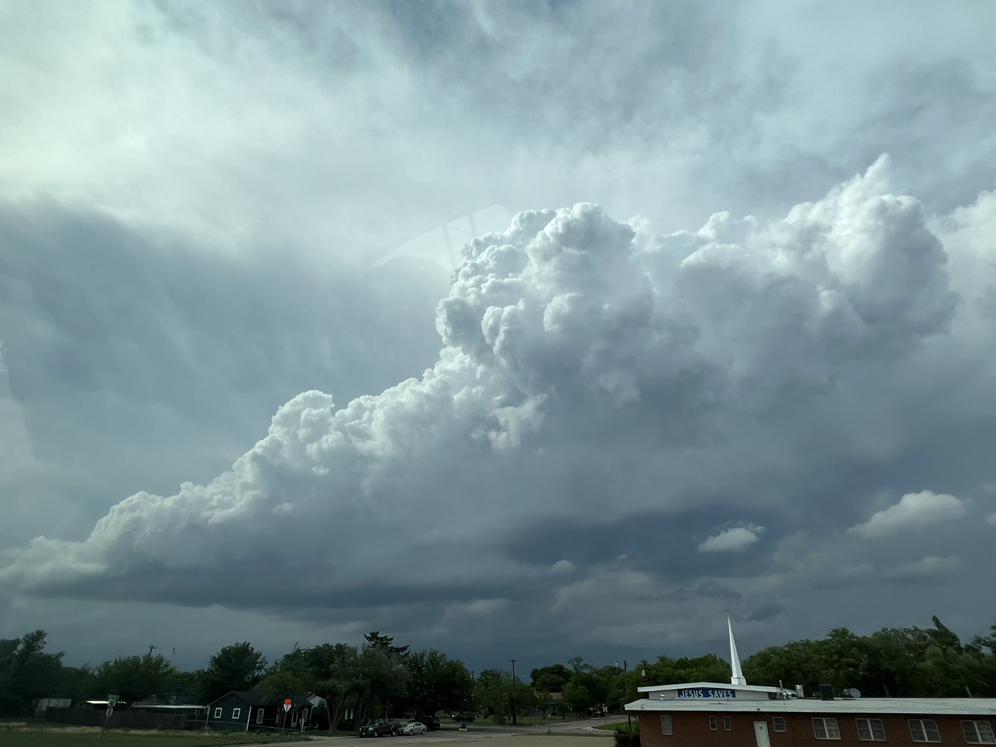
Photos & Video
 |
 |
 |
 |
| Early indications of convective initiation near Amarillo as cumulus congestus began to tower. (Lexy Elizalde) |
Low hanging and weakly rotating wall cloud north of Amarillo (Lexy Elizalde) |
Golf ball to tennis ball size hail collected north of Pantex. (Tony Bunch) |
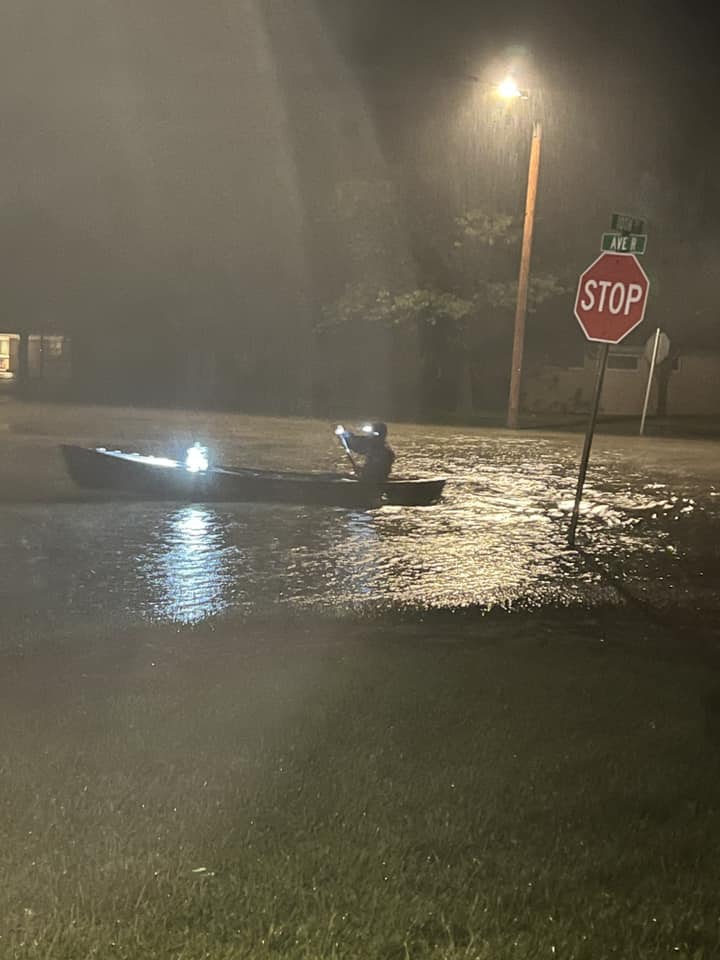
Floating around Sunray in a cano. (Lynelle Morris) |
 |
 |
 |
 |
| Hail core near Stratford (sometimes referred to as a 'whales mouth'. (Rachel) |
Structure after dark with storm near Panhandle (Reed Colten) |
Flooding near Sunray (Melissa Kent) |
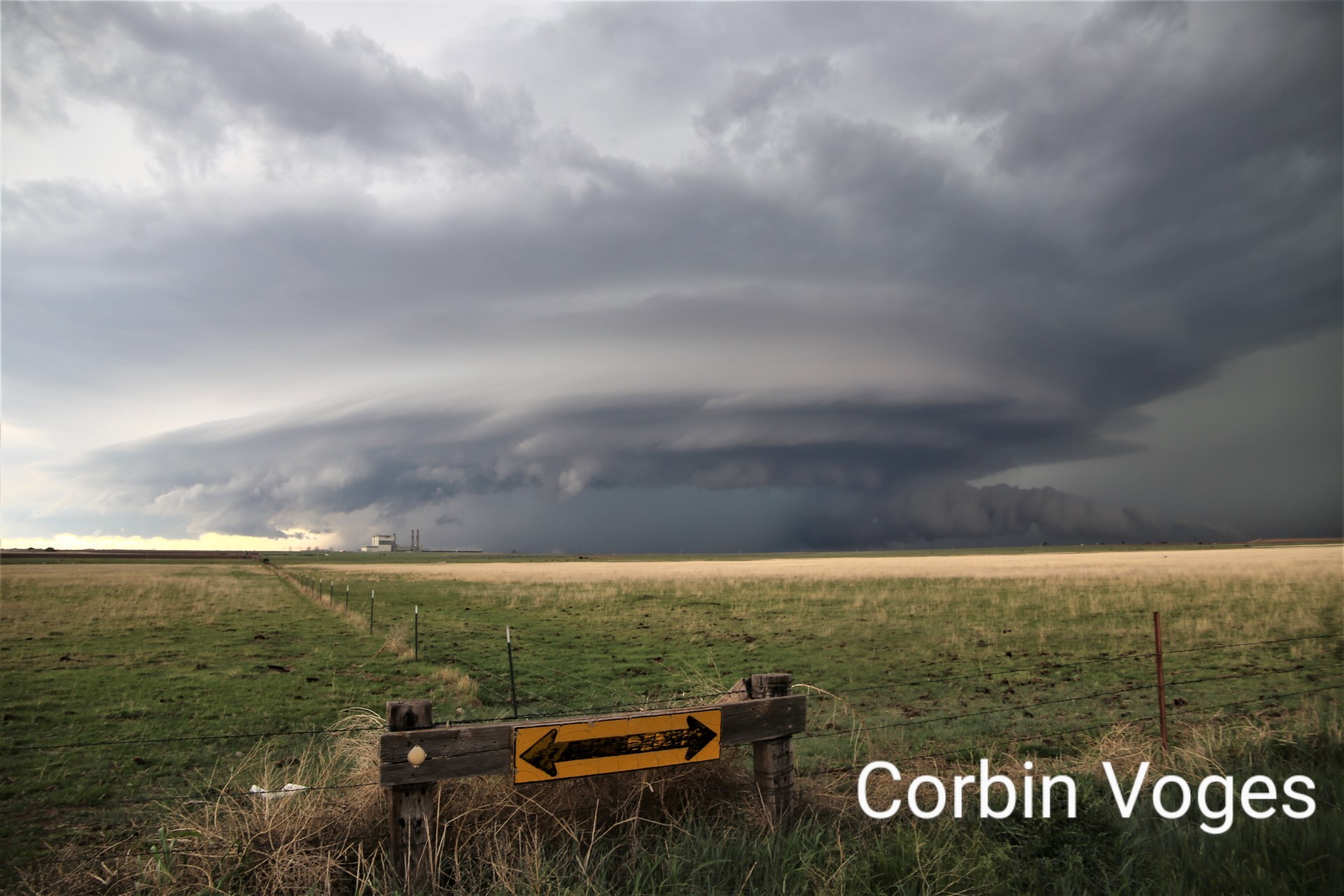
Supercell north of Amarillo. (Corbin Voges) |
Beautiful Canadian River north of Amarillo is flowing more than since the mid 1990s! Peaked above 8 feet last night @accuweather pic.twitter.com/l8J2zcWyEs
— Reed Timmer, PhD (@ReedTimmerAccu) May 19, 2023
Wall cloud 7-8 miles west of Panhandle, Texas is low but stagnant again. Lightning frequency increasing. Time 843 pm @NWSAmarillo @accuweather pic.twitter.com/z6jDbyqmHj
— Reed Timmer, PhD (@ReedTimmerAccu) May 19, 2023
Storm in Canyon way more intense than it looks on radar. 40-50mph wind and heavy rain. @NWSAmarillo #txwx pic.twitter.com/4hUvtb5rRb
— Dr J B Boren (@jimbobfunny) May 19, 2023
@NWSAmarillo Street flooding occurring on the south west side of Amarillo. Bell and Farmers Ave. 22:10. pic.twitter.com/GtUCDDg7Yx
— AmarilloCloudChasing (@amaweather) May 19, 2023
Storm Reports
PRELIMINARY LOCAL STORM REPORT...SUMMARY
NATIONAL WEATHER SERVICE AMARILLO TX
1036 PM CDT FRI MAY 19 2023
..TIME... ...EVENT... ...CITY LOCATION... ...LAT.LON...
..DATE... ....MAG.... ..COUNTY LOCATION..ST.. ...SOURCE....
..REMARKS..
0453 PM HAIL BOYS RANCH 35.51N 102.25W
05/18/2023 E1.00 INCH OLDHAM TX PUBLIC
TIME ESTIMATED BASED ON RADAR.
0604 PM HAIL CONLEN 36.24N 102.24W
05/18/2023 E1.75 INCH DALLAM TX LAW ENFORCEMENT
REPORTED BY STRATFORD PD.
0633 PM HAIL 5 SE CONLEN 36.20N 102.17W
05/18/2023 E1.50 INCH DALLAM TX PUBLIC
WIND DRIVEN HAIL CAUSED EXTENSIVE DAMAGE TO
HOUSE AND TREES. ALL WINDOWS ON NORTH SIDE
OF HOUSE WERE BLOWN OUT. TREES WERE STRIPPED
(EVEN BARK ON THE TREES WAS STRIPPED IN
PLACES). HAIL ACCUMULATIONS OF 6-8 INCHES
CAUSED DENSE HAIL FOG. WINTER WHEAT CROPS IN
THE AREA WERE DESTROYED.
0650 PM HAIL 14 N AMARILLO 35.41N 101.84W
05/18/2023 M2.50 INCH POTTER TX TRAINED SPOTTER
0728 PM TSTM WND DMG 1 NE CACTUS 36.05N 101.99W
05/18/2023 MOORE TX LAW ENFORCEMENT
A METAL ROOF WAS BLOWN OFF ONE OF THE
APARTMENT BUILDINGS AT THE CACTUS JBS
APARTMENTS. TIME ESTIMATED BASED ON RADAR.
0759 PM HAIL 7 NNW PANTEX 35.41N 101.64W
05/18/2023 M1.75 INCH POTTER TX PUBLIC
0810 PM HAIL 4 WNW PANTEX 35.35N 101.64W
05/18/2023 E1.00 INCH POTTER TX STORM CHASER
0842 PM HAIL 2 WSW PANTEX 35.31N 101.62W
05/18/2023 E2.00 INCH CARSON TX TRAINED SPOTTER
0900 PM FLASH FLOOD 1 NE CACTUS 36.05N 102.00W
05/18/2023 MOORE TX LAW ENFORCEMENT
TORRENTIAL RAINFALL RATES OF 3 TO 5 INCHES
PER HOUR RESULTED IN MAJOR STREET FLOODING
THROUGHOUT TOWN. VEHICLES WERE STRANDED WITH
SEVERAL WATER RESCUES. SOME STREETS HAD FAST
FLOWING WATER OVER A FOOT DEEP COVERING THE
STREET.
0914 PM HAIL 4 NNW PANHANDLE 35.40N 101.40W
05/18/2023 M2.00 INCH CARSON TX STORM CHASER
0922 PM TSTM WND GST 1 W CANYON 34.98N 101.95W
05/18/2023 M58 MPH RANDALL TX MESONET
0955 PM HAIL 9 N PANHANDLE 35.48N 101.35W
05/18/2023 M1.00 INCH CARSON TX STORM CHASER
0955 PM TSTM WND GST 9 N PANHANDLE 35.48N 101.35W
05/18/2023 M60 MPH CARSON TX STORM CHASER
STORM CHASER MEASURED WITH HIS ANEMOMETER.
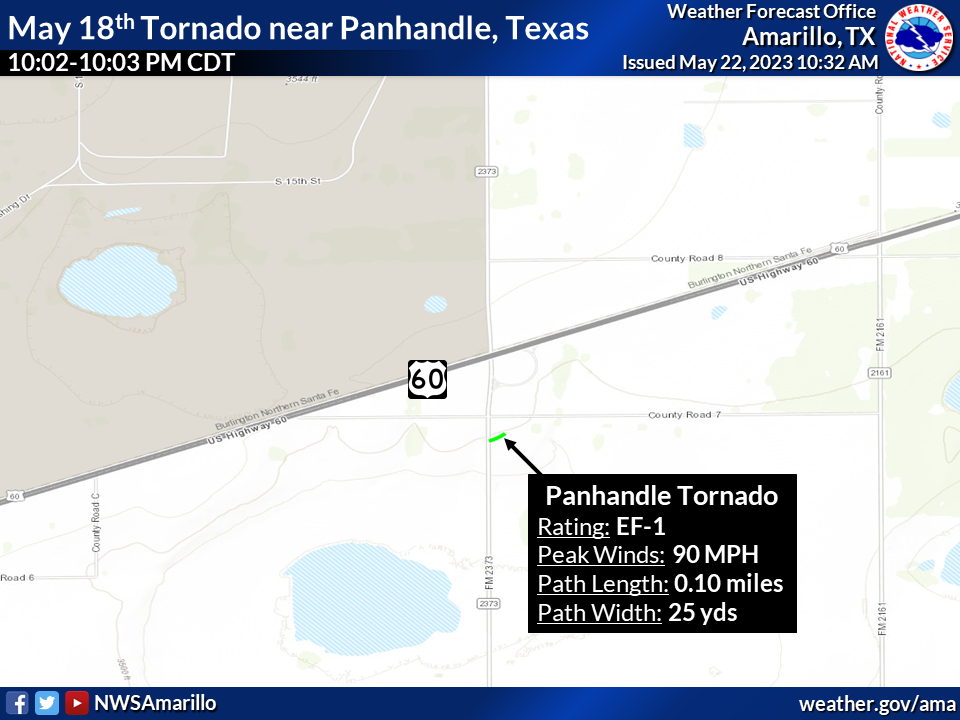
1002 PM TORNADO 4 SE PANTEX 35.28N 101.54W
05/18/2023 CARSON TX NWS STORM SURVEY
A BRIEF TORNADO TOUCHED DOWN JUST TO THE
EAST OF FM2373. IT CAUSED SOME BROKEN TREE
LIMBS AND TOSSED A DUMPSTER SEVERAL YARDS
BACK TO THE SOUTH. IT RESULTED IN DAMAGE TO
AN ATTACHED GARAGE, COLLAPSING THE
STRUCTURE. IT ALSO BLEW SOME HORSE TRAILERS
OVER IN A NEARBY FIELD. THE TORNADO LIFTED
IN AN EMPTY FIELD. MAX WINDS WERE ESTIMATED
AT 90MPH. TOTAL PATH LENGTH ESTIMATED AT
0.10 MILES AND WIDTH AT 25 YARDS.
1015 PM FLASH FLOOD 6 WSW AMARILLO 35.16N 101.90W
05/18/2023 RANDALL TX EMERGENCY MNGR
ACCESS ROADS ON THE SOUTH SIDE OF AMARILLO
ARE ALMOST COMPLETELY UNDERWATER, WITH SOME
PARTS COMPLETELY UNDERWATER. MULTIPLE OTHER
REPORTS WERE ALSO RECEIVED IN THIS AREA.
1022 PM FLASH FLOOD 6 WSW AMARILLO 35.16N 101.92W
05/18/2023 RANDALL TX EMERGENCY MNGR
COULTER IS CLOSED AT THE NORTH AND SOUTH
LANES AT THE INTERSECTION ON 45TH AVE. WATER
RESCUES ARE ONGOING.
1032 PM FLASH FLOOD 3 N CANYON 35.02N 101.92W
05/18/2023 RANDALL TX NWS EMPLOYEE
WATER WAS ACROSS THE CANYON EXIT ON I-27. A
CAR SPUN OUT AND ENDED UP IN A DITCH WITH
DEEP WATER.
1045 PM TSTM WND GST 4 WSW WHITE DEER 35.40N 101.24W
05/18/2023 M58 MPH CARSON TX STORM CHASER
CORRECTS PREVIOUS TSTM WND GST REPORT FROM 4
WSW WHITE DEER. STORM CHASER MEASURED WITH
ANEMOMETER.
1115 PM FLASH FLOOD 1 ESE PALO DURO CANYON 34.94N 101.66W
05/18/2023 RANDALL TX BROADCAST MEDIA
FAST MOVING FLOODWATER MOVED TRUCK BED
CAMPER AT LEAST 30 FEET, WASHED AWAY SEVERAL
TENTS, AND MOVED SEVERAL TRAILERS. FLOODING
LED TO PARK ROAD 5 BEING CLOSED FROM
LIGHTHOUSE PARKING LOT TO CACTUS PICNIC
AREA. TIME ESTIMATED FROM RADAR, MESONET,
AND DOWNSTREAM RIVER OBSERVATIONS.
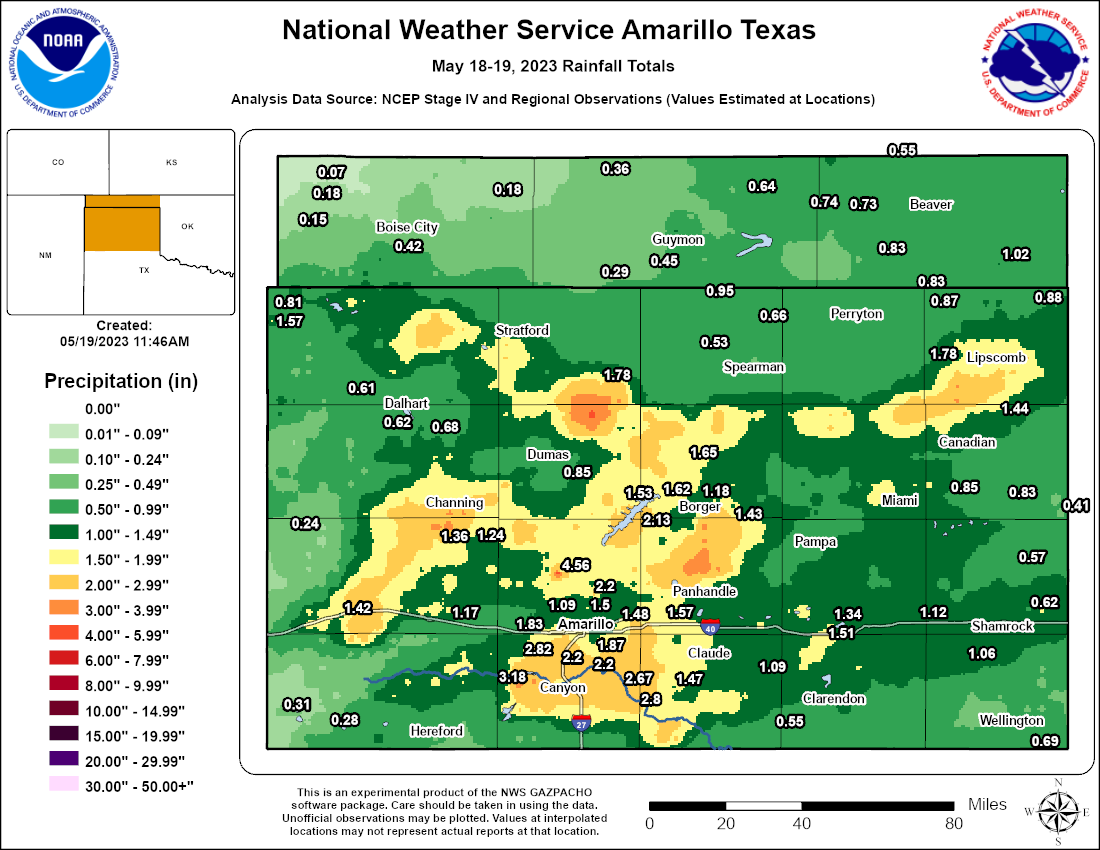
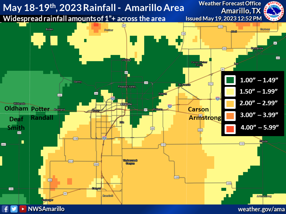
Public Information Statement
National Weather Service Amarillo TX
346 PM CDT Fri May 19 2023

...UPDATED RAINFALL REPORTS FROM THURSDAY MAY 18TH...

Location                     Amount    Time/Date       Provider
10 ESE Valley de Oro         4.56 in   0328 PM 05/19   Mesonet
3 NNE Umbarger               3.18 in   0342 PM 05/19   Mesonet
Amarillo 8.9 SW              2.82 in   0700 AM 05/19   COCORAHS
Canyon 4.2 N                 2.63 in   0700 AM 05/19   COCORAHS
Canyon 0.2 SSW               2.41 in   0700 AM 05/19   COCORAHS
Canyon 3.3 E (COCORAHS)      2.39 in   0700 AM 05/19   COCORAHS
Canyon 0.9 SSE               2.30 in   0700 AM 05/19   COCORAHS
Lake Tanglewood 2E           2.30 in   0700 AM 05/19   COOP
Amarillo 7.2 SW              2.22 in   0733 AM 05/19   COCORAHS
Amarillo 6.0 SSW             2.20 in   0600 AM 05/19   COCORAHS
Amarillo 9.2 S (COCORAHS)    2.20 in   0800 AM 05/19   COCORAHS
9 N Amarillo                 2.20 in   0329 PM 05/19   Mesonet
2 WNW Fritch                 2.14 in   0339 PM 05/19   Mesonet
Amarillo 4.8 WSW (COCORAHS)  2.02 in   0700 AM 05/19   COCORAHS
Amarillo 5.9 WSW (COCORAHS)  1.91 in   0600 AM 05/19   COCORAHS
4 NNW Lake Tanglewood        1.87 in   0340 PM 05/19   Mesonet
Amarillo 10.0 W              1.83 in   0700 AM 05/19   COCORAHS
Canyon 1.9 W (COCORAHS)      1.80 in   0800 AM 05/19   COCORAHS
Canyon 0.9 NNW (COCORAHS)    1.80 in   0700 AM 05/19   COCORAHS
Sunray 9NNE                  1.78 in   0600 AM 05/19   HADS
Lipscomb 8W                  1.78 in   0600 AM 05/19   HADS
9 NNE Sunray                 1.78 in   0343 PM 05/19   Mesonet
Salt Fork Red River Tributar 1.77 in   0600 AM 05/19   HADS
8 W Lipscomb                 1.77 in   0338 PM 05/19   Mesonet
2 N Stinnett                 1.64 in   0338 PM 05/19   Mesonet
Sanford Dam                  1.62 in   0600 AM 05/19   COOP
Amarillo 9.0 W               1.60 in   0800 AM 05/19   COCORAHS
Amarillo 1.6 W               1.58 in   0700 AM 05/19   COCORAHS
Texline 0.3 WNW              1.57 in   0530 AM 05/19   COCORAHS
3 SE Pantex                  1.57 in   0333 PM 05/19   Mesonet
Amarillo 5.7 WNW             1.51 in   0700 AM 05/19   COCORAHS
Jericho                      1.51 in   0735 AM 05/19   COOP
Amarillo 3.1 N               1.50 in   0915 AM 05/19   COCORAHS
Amarillo (ASOS)              1.48 in   0610 AM 05/19   ASOS
Borger 7E                    1.45 in   0600 AM 05/19   HADS
Glazier                      1.44 in   0600 AM 05/19   COOP
7 E Borger                   1.43 in   0338 PM 05/19   Mesonet
6 WSW Adrian                 1.42 in   0339 PM 05/19   Mesonet
1 SSW Panhandle              1.37 in   0333 PM 05/19   Mesonet
1 NW Boys Ranch              1.36 in   0339 PM 05/19   Mesonet
2 WNW Lake Mcclellan         1.34 in   0336 PM 05/19   Mesonet
Borger 0.7 NNE               1.25 in   0700 AM 05/19   COCORAHS
Higgins                      1.24 in   0800 AM 05/19   COOP
Panhandle 0.1 NNE            1.20 in   0800 AM 05/19   COCORAHS
Borger 4.4 WSW               1.19 in   0650 AM 05/19   COCORAHS
Vega 2NW                     1.18 in   0700 AM 05/19   COOP
Borger (ASOS)                1.18 in   0551 AM 05/19   ASOS
4 E Vega                     1.18 in   0340 PM 05/19   Mesonet
Vega 4E                      1.17 in   0600 AM 05/19   HADS
1 ENE Mclean                 1.12 in   0336 PM 05/19   Mesonet
Amarillo 9.9 WNW (COCORAHS)  1.09 in   0700 AM 05/19   COCORAHS
Goodnight                    1.09 in   0330 PM 05/19   Mesonet
2.9 E Channing               1.07 in   0530 AM 05/19   HADS
3 W Dozier                   1.06 in   0334 PM 05/19   Mesonet
Pampa 3E                     1.00 in   0800 AM 05/19   COOP
Guymon (ASOS)                0.98 in   0553 AM 05/19   ASOS
6 E Canadian                 0.98 in   0337 PM 05/19   Mesonet
Gruver 14.0 N                0.95 in   0700 AM 05/19   COCORAHS
Bushland Usda-Ars (COOP)     0.94 in   0830 AM 05/19   COOP
Tyrone 0.2 WSW               0.90 in   0800 AM 05/19   COCORAHS
Follett                      0.88 in   0555 AM 05/19   COOP
Booker 0.5 SSE               0.87 in   0830 AM 05/19   COCORAHS
Miami 10E (RS)               0.85 in   0600 AM 05/19   HADS
Dumas (AWOS)                 0.85 in   0615 AM 05/19   AWOS
Dumas 3SE                    0.85 in   0600 AM 05/19   HADS
Pampa (AWOS)                 0.84 in   0615 AM 05/19   AWOS
Booker 3.4 NW                0.83 in   0800 AM 05/19   COCORAHS
Briscoe 8.1 NNE              0.83 in   0700 AM 05/19   COCORAHS
Balko 8.4 W                  0.83 in   0730 AM 05/19   COCORAHS
Slapout                      0.82 in   0605 AM 05/19   OK-MESO
Stratford 0.5 ESE            0.81 in   0700 AM 05/19   COCORAHS
Hereford 1.1 N (COCORAHS)    0.81 in   0630 AM 05/19   COCORAHS
PANHANDLE GRASSLAND GOODWELL 0.75 in   0610 AM 05/19   HADS
Turpin 5.2 S                 0.74 in   0800 AM 05/19   COCORAHS
Hereford 2.4 ENE (COCORAHS)  0.73 in   0700 AM 05/19   COCORAHS
Turpin 6.1 SSE (COCORAHS)    0.73 in   0700 AM 05/19   COCORAHS
3.3 N Shamrock               0.70 in   0545 AM 05/19   HADS
Stratford 4WNW               0.69 in   0600 AM 05/19   HADS
Dalhart 9.6 SSE              0.68 in   0700 AM 05/19   COCORAHS
OK PANHANDLE ST (PERM PASTUR 0.68 in   0530 AM 05/19   HADS
Dalhart 2SE                  0.68 in   0700 AM 05/19   COOP
Wellington 6SE               0.64 in   0600 AM 05/19   HADS
Wheeler 13.3 SSE             0.62 in   0700 AM 05/19   COCORAHS
Dalhart (ASOS)               0.62 in   0553 AM 05/19   ASOS
Dalhart 8.1 W                0.61 in   0800 AM 05/19   COCORAHS
Perryton 1.8 ENE             0.60 in   0700 AM 05/19   COCORAHS
Wheeler Raws                 0.57 in   0552 AM 05/19   RAWS
Perryton 10.4 WSW            0.57 in   0700 AM 05/19   COCORAHS
2.7 NE Romero                0.56 in   0530 AM 05/19   HADS
Forgan 10.4 NW (COCORAHS)    0.55 in   0700 AM 05/19   COCORAHS
3.7 SW Buffalo Lake          0.53 in   0600 AM 05/19   HADS
Gruver                       0.53 in   0649 AM 05/19   COOP
Beaver                       0.52 in   0250 PM 05/19   OK-MESO
Hooker                       0.51 in   0605 AM 05/19   OK-MESO
9.2 S Allison                0.47 in   0545 AM 05/19   HADS
Felt 2.8 ESE                 0.46 in   0800 AM 05/19   COCORAHS
Allison 5ENE                 0.41 in   0700 AM 05/19   COOP
Goodwell                     0.40 in   0605 AM 05/19   OK-MESO
Boise City                   0.40 in   0605 AM 05/19   OK-MESO
8.5 NW Waka                  0.33 in   0545 AM 05/19   HADS
11 WNW Bootleg               0.31 in   0335 PM 05/19   Mesonet
Texhoma 1.8 N                0.29 in   0700 AM 05/19   COCORAHS
Bootleg (RAWS)               0.27 in   0603 AM 05/19   RAWS
Keyes 10.3 NE                0.25 in   0700 AM 05/19   COCORAHS
11 S Romero                  0.24 in   0340 PM 05/19   Mesonet
0.6 NE Beaver                0.21 in   0600 AM 05/19   HADS
Keyes 5.9 N                  0.18 in   0800 AM 05/19   COCORAHS
Goodwell 7 N                 0.17 in   0530 AM 05/19   USGS
Kenton 12.1 S                0.15 in   0751 AM 05/19   COCORAHS
Kenton                       0.15 in   0605 AM 05/19   OK-MESO
Kenton 6.1 E                 0.07 in   0800 AM 05/19   COCORAHS
Environment
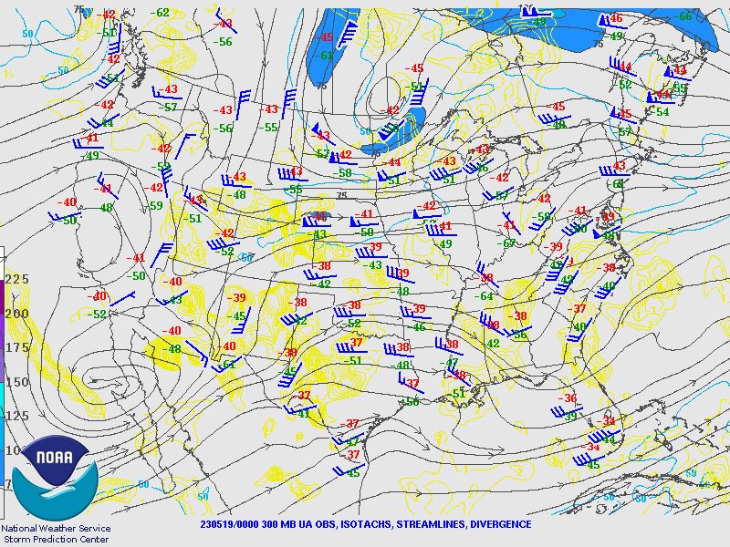
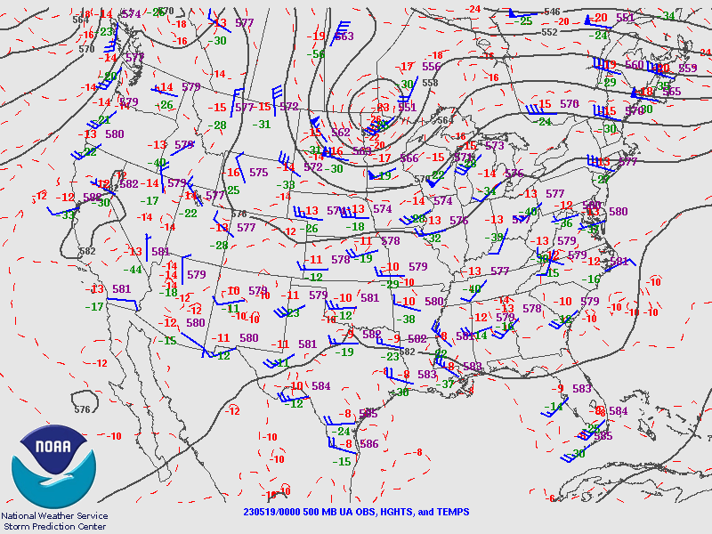
The synoptic environment was characterized by broad low pressure off the Baja coast, a progressive trough over the northern plains, and minor ridging over the south plains. Height falls were noted through the day as a shortwave moved across the southern Rocky Mountains. Relatively weak winds aloft supported the idea that storms would not be fast moving.
 |
 |
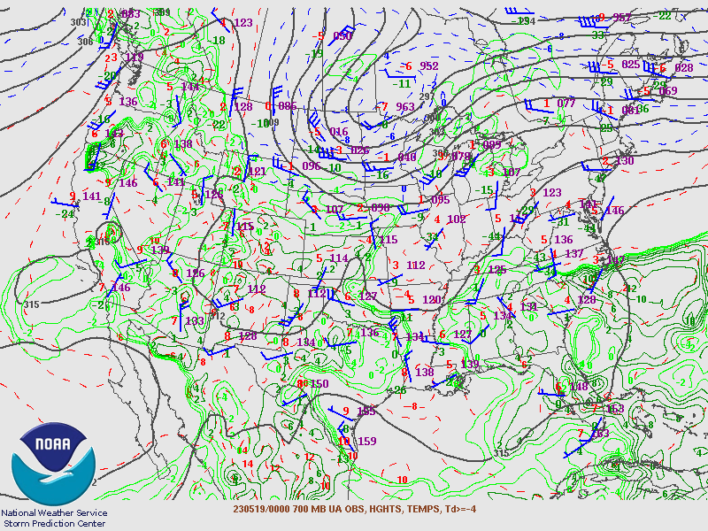 |
| Figure 1: 300mb UA Obs, Isotachs, streamlines, divergence | Figure 2: 500mb UA Obs, Heights, and Temps | Figure 3: 700mb UA Obs, Hghts, temps, Td >= -4 |
 |
 |
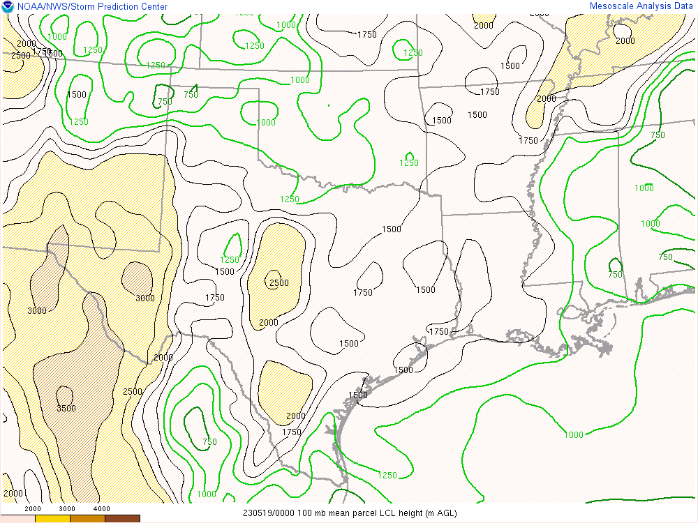 |
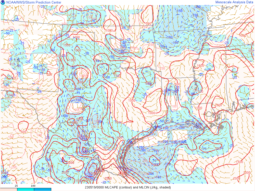
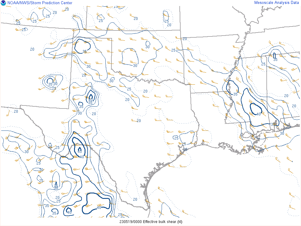
| Figure 4: MLCAPE & MLCIN | Figure 5: Effective Shear | Figure 6: LCL Heights |
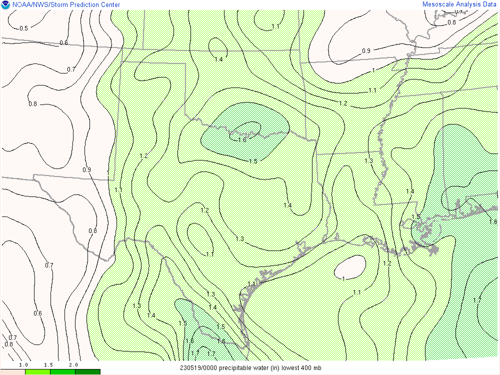
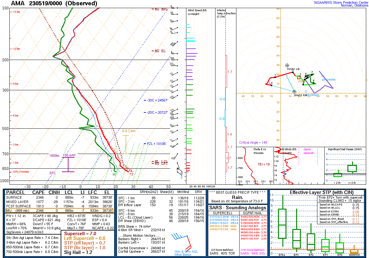
The precipitable water content was well above normal for mid May which combined with slow moving and merging storms to produce a flash flood threat.
 |
 |
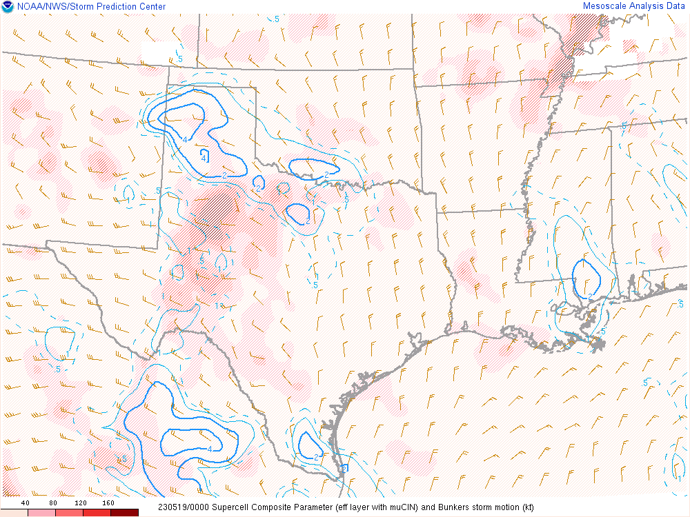 |
| Figure 7: PWATs | Figure 8: AMA 5/19 00z RAOB | Figure 9: Supercell Composite (Right Moving) |
 |
Media use of NWS Web News Stories is encouraged! Please acknowledge the NWS as the source of any news information accessed from this site. |
|