Please use the links below to find out more information on current flooding issues and details of any warnings that may be currently issued.
Quick Links:
Latest Information
|
||||||||
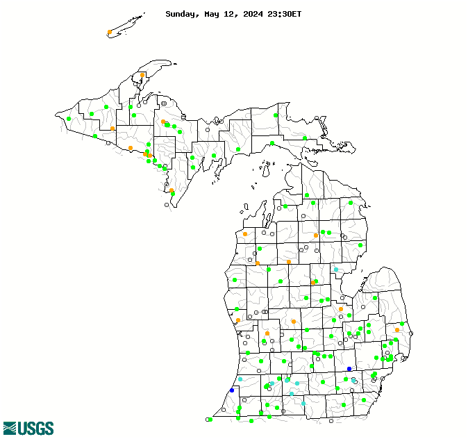
Current River/Streamflow Information
|
|||||
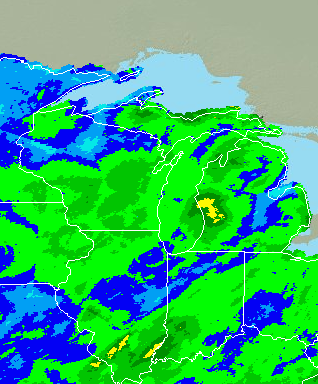
Precipitation Info/Forecasts
|
||||||||
000
FLUS43 KAPX 191954
HWOAPX

Hazardous Weather Outlook
National Weather Service Gaylord MI
354 PM EDT Fri Apr 19 2024

MIZ016>018-020>036-041-042-086>088-095>099-202000-
Emmet-Cheboygan-Presque Isle-Leelanau-Antrim-Otsego-Montmorency-
Alpena-Benzie-Grand Traverse-Kalkaska-Crawford-Oscoda-Alcona-
Manistee-Wexford-Missaukee-Roscommon-Ogemaw-Iosco-Gladwin-Arenac-
Western Chippewa-Central Chippewa-Southeast Chippewa-
Western Mackinac-Eastern Mackinac-
Mackinac Island/Bois Blanc Island-
Beaver Island and surrounding islands-Charlevoix-
354 PM EDT Fri Apr 19 2024

This hazardous weather outlook is for Eastern Upper Michigan and
Northern Lower Michigan.

.DAY ONE...This afternoon and tonight.

No hazardous weather is expected at this time.

.DAYS TWO THROUGH SEVEN...Saturday through Thursday.

No hazardous weather is expected at this time.

.SPOTTER INFORMATION STATEMENT...

Spotter activation is not anticipated.

For more information visit http://weather.gov/gaylord.

$$

LHZ345>349-LMZ323-341-342-344>346-LSZ321-322-202000-
Straits of Mackinac within 5 nm of Mackinac Bridge including
Mackinac Island-St Ignace to False Detour Channel-
5NM East of Mackinac Bridge to Presque Isle Light MI including
Bois Blanc Island-
Presque Isle Light to Sturgeon Pt MI Including Thunder Bay
National Marine Sanctuary-Sturgeon Pt to Alabaster MI-
Grand Traverse Bay south of a line Grand Traverse Light to
Norwood MI-Seul Choix Point to 5NM West of Mackinac Bridge-
Norwood MI to 5NM West of Mackinac Bridge including Little
Traverse Bay-Sleeping Bear Point to Grand Traverse Light MI-
Point Betsie to Sleeping Bear Point MI-
Manistee to Point Betsie MI-
Whitefish Bay (U.S. Portion)/Whitefish Point to Point Iroquois MI-
St. Marys River Point Iroquois to E. Potagannissing Bay-
354 PM EDT Fri Apr 19 2024

This hazardous weather outlook is for the northern Michigan
nearshore waters of Lake Huron, Lake Michigan and Lake Superior.

.DAY ONE...This afternoon and tonight.

No hazardous weather is expected at this time.

.DAYS TWO THROUGH SEVEN...Saturday through Thursday.

No hazardous weather is expected at this time.

.SPOTTER INFORMATION STATEMENT...

Spotter activation is not anticipated.

For more information visit http://weather.gov/gaylord.

$$
000
ACUS01 KWNS 191952
SWODY1
SPC AC 191950

Day 1 Convective Outlook
NWS Storm Prediction Center Norman OK
0250 PM CDT Fri Apr 19 2024

Valid 192000Z - 201200Z

...THERE IS A MARGINAL RISK OF SEVERE THUNDERSTORMS OVER PARTS OF
THE SOUTHEAST...

...SUMMARY...
Sporadic strong to marginally severe storms are possible over parts
of the Southeast this afternoon into the early evening.

Little change made to the outlook at 20Z.

...Southeast...
Strong heating continues well ahead of the cold front, beneath
modest west/northwest flow aloft. Midlevel lapse rates are poor, but
sufficient instability coupled with the heated boundary layer and
sufficient flow should support a few storms capable of damaging
gusts or marginal hail with the more robust cells. Convergence near
a weak low and a zone of mid 60s F dewpoints over central NC/eastern
SC may yield the strongest cells.

See mesoscale discussion 494 for more details.

..Jewell.. 04/19/2024

.PREV DISCUSSION... /ISSUED 1126 AM CDT Fri Apr 19 2024/

...Southeast this afternoon/evening...
Late morning water-vapor imagery shows a mid-level shortwave trough
moving east across the southern Appalachians.  This feature will
reach the VA/NC coast early tonight.  Farther northwest, a closed
midlevel low will evolve into an open wave as it moves eastward over
the Great Lakes and OH Valley.  An associated surface cold front
will continue to move slowly southeastward from TX to the southern
Appalachians.  Isolated to widely scattered thunderstorms will be
possible with the disturbance over the Carolinas this afternoon.
Other than the front pushing into portions of AL/GA, little
larger-scale forcing for ascent is expected farther southwest.
Additional storm development will be associated with the front and
orographic lift along the spine of the Appalachians.  Overall
weak-moderate buoyancy, modest deep-layer shear and steepening
low-level lapse rates will support some potential semi-organized
storms capable of producing isolated wind damage and marginally
severe hail for a few hours this afternoon/evening.

...TX through tonight...
--No change needed to previous forecast discussion--
Weak upslope flow along a slow moving cold front will favor
thunderstorm development over the east slopes of the Sierra Madre
Oriental/Sierra del Burro this afternoon, with the potential for a
couple of supercells.  However, it is not clear that storm motions
will bring the convection across the Rio Grande, and lingering
convective inhibition suggests storms will likely weaken if they
manage to cross the border.  Later tonight in northwest TX, elevated
convection will likely develop atop the frontal surface, in a warm
advection regime downstream from a weak shortwave trough over AZ/NM.
Some small hail may occur given lingering steep midlevel lapse rates
and modest cloud-layer shear, but the potential for severe hail
appears too low to warrant an outlook area.

$$
000
ACUS02 KWNS 191653
SWODY2
SPC AC 191652

Day 2 Convective Outlook
NWS Storm Prediction Center Norman OK
1152 AM CDT Fri Apr 19 2024

Valid 201200Z - 211200Z

...THERE IS A MARGINAL RISK OF SEVERE THUNDERSTORMS OVER MUCH OF
CENTRAL TEXAS AND FROM SOUTHERN ALABAMA ACROSS GEORGIA AND INTO
SOUTHERN SOUTH CAROLINA...

...SUMMARY...
Marginally severe storms capable of strong wind gusts and hail will
be possible on Saturday across much of central Texas, and during the
afternoon from southern Alabama across parts of Georgia and into
southern South Carolina.

...Synopsis...
An upper trough will move east from the Great Lakes into the
Northeast, as the parent upper low deepens over Hudson Bay. Moderate
westerly flow aloft will remain from the central Plains to the East
Coast, with a low-latitude wave moving from AZ/NM across the
southern Plains through Saturday night.

At the surface, high pressure will extend south and eastward across
much of the central and eastern CONUS, with a front from the coastal
Carolinas to the northern Gulf Coast and into southern TX. A moist
air mass will remain south of this boundary in TX, where lift north
of the boundary will lead to increase rain and thunderstorms.

...TX...
Primarily elevated thunderstorms are likely through much of the day
over parts of central and northern TX, with activity extending east
toward northern MS. This activity will be supported by modest warm
advection just above the cool post-frontal air mass. Instability may
still be substantial, especially just north of the surface front. As
such, a few hail reports will be possible over a relatively large
area, with a conditional risk of strong gusts closer to the front.

...Coastal SC into southern GA and AL...
The surface boundary will extend roughly from coastal SC across GA
and into southern AL during the afternoon, with strong heating
expected. Although gradual drying will occur due to westerly flow,
strong heating and sufficient moisture will still result in an
unstable air mass, and eastward-moving storms producing outflow are
anticipated. Given the steep low-level lapse rates, 1000-1500 SBCAPE
and sufficient deep-layer mean winds, isolated damaging gusts will
be possible.

..Jewell.. 04/19/2024

$$
000
NWUS53 KAPX 172100
LSRAPX

Preliminary Local Storm Report
National Weather Service Gaylord MI
500 PM EDT Wed Apr 17 2024

..TIME...   ...EVENT...      ...CITY LOCATION...     ...LAT.LON...
..DATE...   ....MAG....      ..COUNTY LOCATION..ST.. ...SOURCE....
            ..REMARKS..

0206 PM     Non-Tstm Wnd Gst Mackinaw City           45.78N 84.73W
04/17/2024  M48 MPH          Cheboygan          MI   Buoy

            Buoy station MACM4 Mackinaw City, MI.


&&

$$
000
FXUS63 KAPX 192300
AFDAPX
Area Forecast Discussion
National Weather Service Gaylord MI
700 PM EDT Fri Apr 19 2024
.KEY MESSAGES...
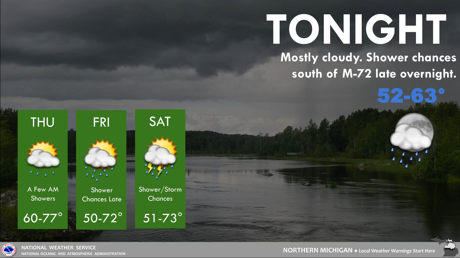
- Rain/snow chances tonight through Saturday, with the
potential for graupel to mix in with any heavier showers.
- Cooler than normal temperatures through the middle of next
week but no high impact weather expected.
&&
.SHORT TERM /THROUGH TONIGHT/...
Pattern Synopsis/Forecast: Closed upper-level low pressure continues
to spin across northern Ontario with broad/amplified troughing
draped across the Great Lakes and upper MS Valley. Attendant surface
low expected to follow suit to the northeast into Quebec by this
evening. Initial cold front already east of our area with a
secondary front expected to cross northwest to southeast later
tonight into Saturday morning.
Forecast Details: Partly sunny skies across much of northern
lower this afternoon with more cloud cover north of the bridge
in closer proximity to the aforementioned surface low. Relatively
steep lapse rates and increasing low-level moisture already
supporting showers developing this afternoon across eastern
upper. These showers perhaps mixed with graupel and/or snow at
times into the overnight hours. Those chances spread across
northwest lower and the tip of the mitt this evening and
overnight with lower probabilities across northeast lower and
especially near Saginaw Bay. Any snow accumulation likely
minimal with some locations perhaps picking up a coating to a
few tenths of an inch. Low temps tonight generally within a
couple of degrees on either side of freezing -- coldest inland
from the Great Lakes.
A similar story anticipated for Saturday with at least low chances
for showers continuing under partly to mostly cloudy skies. While
afternoon highs likely reach into the low-mid 40s area-wide, some
snow mixing in remains a possibility, especially for the typically
cooler/interior spots. Again, a minor accumulation not entirely out
of the question, although with little impact expected.
&&
.LONG TERM /SUNDAY THROUGH THURSDAY/...
Still expecting a breezy and cool weather pattern across the region
over the next several days as a trough becomes established across
northeast Canada. Do expect this trough to eventually give up the
ghost late next week leading to warming temperatures. Looking
farther ahead, above normal temperatures are expected for the last
few days of the month. Precipitation chances in the long term are
limited to Monday night into Tuesday night from a short wave moving
in off of the Pacific and Friday via warm air advection. A majority
of the upcoming low temperatures (with the exception of perhaps
Monday night) will be at or below freezing with at least a couple of
nights potentially as low as the low and mid 20s.
&&
.AVIATION /00Z TAFS THROUGH 00Z SUNDAY/...
Deep troughing will remain over the Great Lakes region thru
Saturday night...resulting in mainly cloudy skies...low VFR cigs
and scattered light rain/snow showers for the next 24 hours.
Surface winds will remain from the west at 10 to 15 kts
tonight...strengthening again to 15 to 25 kts on Saturday.
&&
.APX WATCHES/WARNINGS/ADVISORIES...
MI...None.
MARINE...Small Craft Advisory until midnight EDT tonight for LHZ345>349.
Small Craft Advisory until 5 AM EDT Saturday for LMZ323-341-
342-344>346.
Small Craft Advisory until 8 PM EDT Saturday for LSZ321.
&&
$$
SHORT TERM...MJG
LONG TERM...AJS
AVIATION...MLR
000
ACUS11 KWNS 192155
SWOMCD
SPC MCD 192154
GAZ000-ALZ000-MSZ000-192330-

Mesoscale Discussion 0497
NWS Storm Prediction Center Norman OK
0454 PM CDT Fri Apr 19 2024

Areas affected...Portions of far east-central MS...northern/central
AL...and northern GA

Concerning...Severe potential...Watch unlikely

Valid 192154Z - 192330Z

Probability of Watch Issuance...5 percent

SUMMARY...A couple loosely organized storms capable of marginally
severe hail and locally damaging gusts are possible for the next
couple hours. Watch not expected.

DISCUSSION...Isolated thunderstorms are developing across portions
of northern AL this afternoon, ahead of an outflow-augmented cold
front draped across the region. Attempts at convective initiation
are also evident over far east-central MS and northern GA.
Antecedent heating/destabilization of a moist boundary layer (upper
60s/lower 70s dewpoints) has yielded moderate surface-based
instability ahead of the front. This may support a couple loosely
organized multicells and transient supercell structures, given 30-35
kt of effective shear -- characterized by a mostly straight
hodograph (with weak low-level shear). Therefore, marginally severe
hail (near 1 inch in diameter) and locally damaging gusts cannot be
ruled out with any robust/sustained cores during the next couple
hours, before the onset of nocturnal cooling/stabilization. Weak
synoptic and mesoscale ascent should keep the severe risk localized,
and a watch is not expected.

..Weinman/Guyer.. 04/19/2024

...Please see www.spc.noaa.gov for graphic product...

ATTN...WFO...GSP...FFC...BMX...HUN...MEG...JAN...

LAT...LON   33938810 34738544 34948442 34928373 34698342 34288342
            33948386 33478492 32958697 32778803 32878856 33118886
            33458893 33698866 33938810


 Follow us on YouTube