Waterspouts
By Bruce B. Smith, Meteorologist, NWS Gaylord
1. What is a Waterspout?
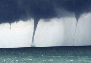
Persons living in northern Michigan are well aware that the Great Lakes have a profound impact on local weather patterns. Examples include heavy lake effect snows in winter, and cooling lake breezes in summer. As the end of the summer season approaches, another type of unique Great Lakes weather phenomena is possible -- the waterspout. The following photo is of a waterspout over the Great Lakes.
Dr. Joseph Golden, a distinguished waterspout authority with the National Oceanic and Atmospheric Administration (NOAA), defines the waterspout as a "funnel which contains an intense vortex, sometimes destructive, of small horizontal extent and which occurs over a body of water." The belief that a waterspout is nothing more than a tornado over water is only partially true. The fact is, depending on how they form, waterspouts come in two types: tornadic and fair weather.
Tornadic waterspouts generally begin as true tornadoes over land in association with a thunderstorm, and then move out over the water. They can be large and are capable of considerable destruction. Fair weather waterspouts, on the other hand, form only over open water. They develop at the surface of the water and climb skyward in association with warm water temperatures and high humidity in the lowest several thousand feet of the atmosphere. They are usually small, relatively brief, and less dangerous. The fair weather variety of waterspout is much more common than the tornadic.
Waterspouts occur most frequently in northern Michigan during the months of August, September, and October, when the waters of the Great Lakes are near their warmest levels of the year. Waterspout formation typically occurs when cold air moves across the Great Lakes and results in large temperature differences between the warm water and the overriding cold air. They tend to last from about two to twenty minutes, and move along at speeds of 10 to 15 knots.
Dr. Joseph Golden distinguishes five stages of waterspout formation:
2. How does the National Weather Service forecast waterspouts?
National Weather Service (NWS) meteorologists consider forecasting waterspouts during the late summer and fall whenever large, cool air masses overspread the waters of the Great Lakes. Water temperature, air temperature, moisture, and wind speed in the lowest several thousand feet of the atmosphere are among the parameters forecasters assess when determining the likelihood of waterspouts. Waterspouts become favorable when water temperatures are warm, the air is cold and moist, and wind speeds are relatively light.
3. What forecasts and warnings are issued by the National Weather Service to warn of waterspouts?
Once the NWS has determined that waterspouts are possible, the threat is outlined in the Nearshore Marine Forecast and Hazardous Weather Outlook. The NWS strives to provide this information to the public 12 to 24 hours prior to waterspout occurrence.
When waterspouts have been detected by Doppler Radar or reported by local law enforcement or spotters, the NWS issues a Special Marine Warning. Since it is not uncommon for numerous waterspouts to occur simultaneously over a large area, these warnings tend to cover larger geographic areas than land-based tornado warnings which generally cover a single county.
In most cases, waterspouts which make landfall are much weaker than tornadoes, produce little or no damage, and dissipate quickly. Once on land, they tend not to be a great threat to life and property. In these instances, the NWS issues a Tornado Warning.
4. What should you do?
Take waterspouts seriously. If you are a boater or a person living along the coast of the Great Lakes you should be aware of their destructive potential. When warnings are issued for waterspouts, be prepared to quickly seek safe harbor, or to find shelter out of the path of the waterspout.
Your best source for waterspout forecast information is NOAA Weather Radio (NWR). These continuous broadcasts from transmitters scattered around the Great Lakes provide forecasts and warnings 24 hours a day.


 Follow us on YouTube