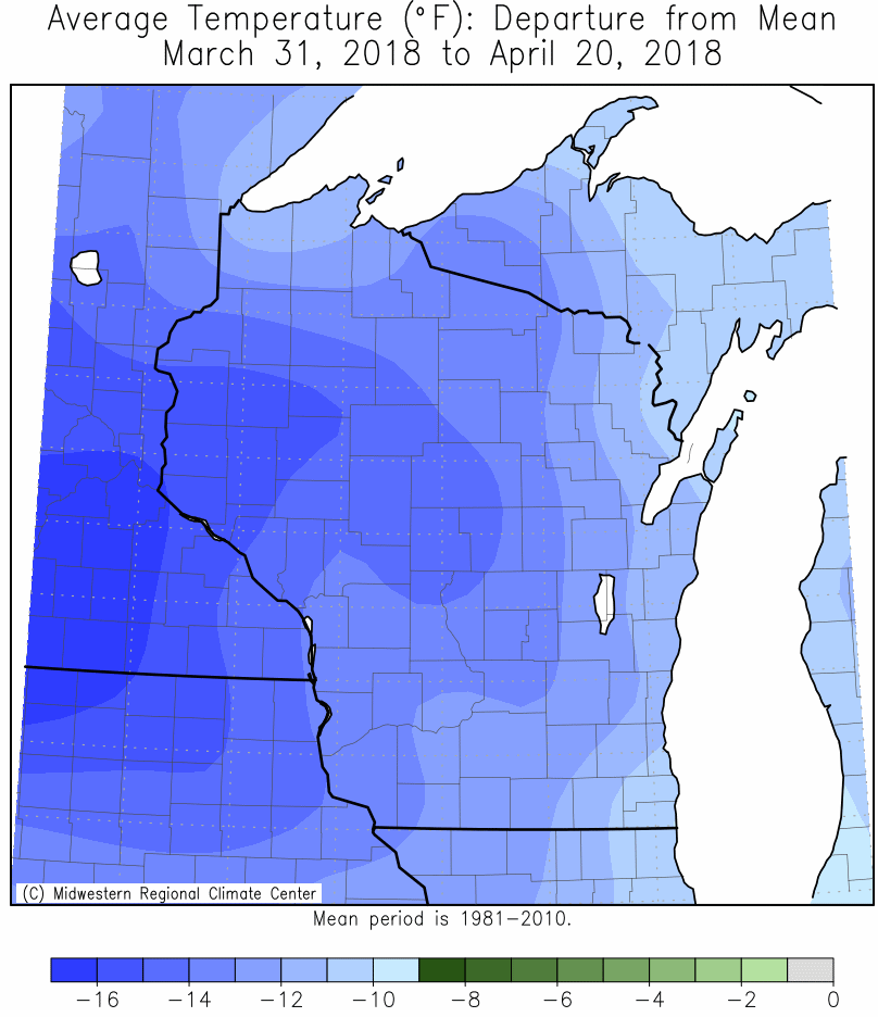
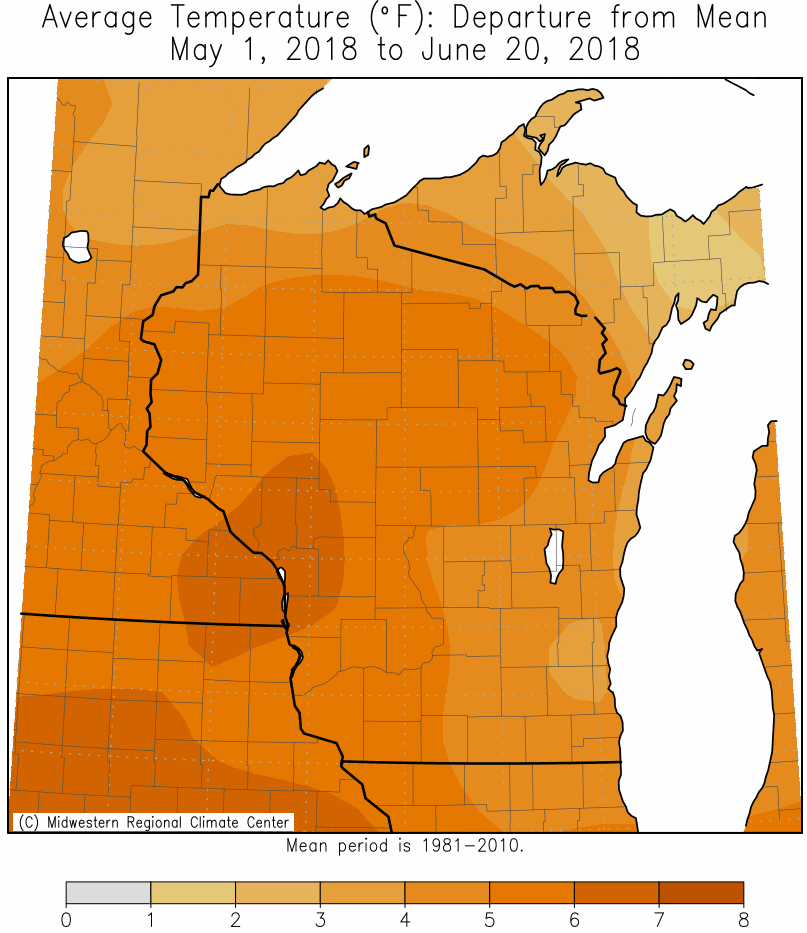
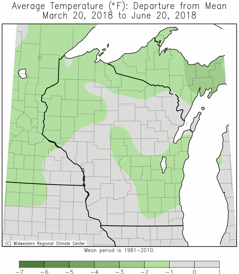
While astronomical Spring 2018 (March 20-June 20) temperatures averaged close to normal, they were far from that. From March 31 through April 20, temperatures averaged double digits below normal. This was the coldest ever recorded for this time period. Meanwhile, in contrast, the area experienced the warmest May 1 through June 20 ever recorded. This warmth accelerated plant growth, so by the end spring plants were close to normal or slightly ahead of schedule. The maps below are courtesy of the Midwestern Regional Climate Center.
 |
 |
 |
| March 31-April 20 Temperature Departures |
May 1- June 20 Temperatures Departures |
Spring 2018 Temperature Departures |
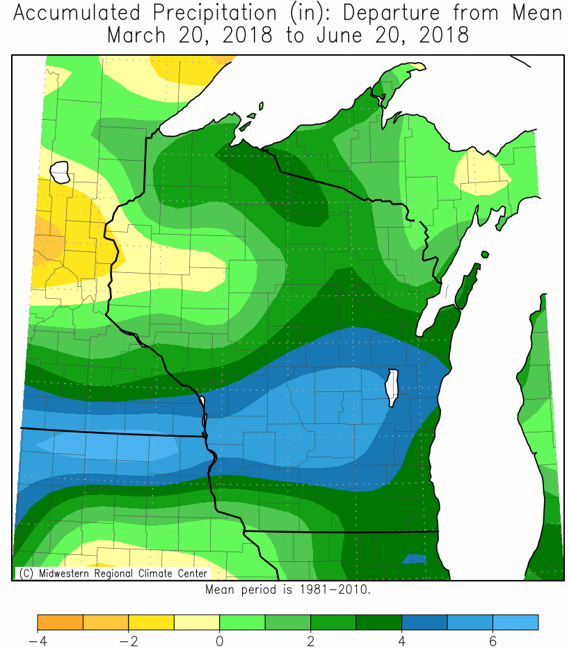
As far as precipitation goes, it was another wet astronomical spring across the Upper Mississippi River Valley. The wettest locations were along and just south of the Interstate 90 corridor. La Crosse WI has had 8 of their 20 wettest springs occur this century. Meanwhile, Rochester MN has had 9 of their 20 wettest springs occur this century. During April, much of this precipitation fell as snow. It was the snowiest spring in La Crosse WI and tied for the 4th snowiest at Rochester MN. The maps below are courtesy of the Midwestern Regional Climate Center.
 |
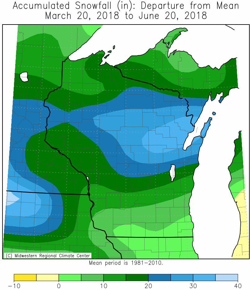 |
| Spring 2018 Precipitation Departures | Spring 2018 Snowfall Departures |
More details for La Crosse, WI and Rochester MN can be found below.
During the astronomical spring of 2018, temperatures averaged warmer (average temperature was 55.5°F or +1°F departure from average) and wetter (total precipitation 13.78 inches which was +3.67 inches greater than average - tied for 19th wettest) than average at La Crosse Regional Airport. It was the snowiest astronomical spring (19.0 inches which was 14.1 inches greater than average) and was tied for 7th greatest average snow depth. More details on these statistics can be found below.
From March 20 through June 20, La Crosse Regional Airport had an average temperature of 55.5°F. This was 1°F warmer than the long-term (1873-2018) average of 54.5°F.
From March 20 through June 20, La Crosse Regional Airport received 13.78" of precipitation. This was 3.67" wetter than the long-term (1873-2018) average of 10.11". This tied 1967 for the 19th wettest astronomical spring in La Crosse WI. The table below contains the 20 wettest astronomical springs in La Crosse WI.
Top 20 Wettest Astronomical Springs
in La Crosse WI
1873-2018
Precipitation
Rank Total Year
---- ------------- ----
1 23.08 inches 1993
2 18.87 inches 1899
3 18.47 inches 2004
4 18.19 inches 2008
5 18.10 inches 2011
6 17.51 inches 1973
7 16.58 inches 2013
8 16.20 inches 1991
9 16.19 inches 1892
10 16.13 inches 1960
11 15.39 inches 1880
12 15.27 inches 2017
13 14.72 inches 2014
14 14.68 inches 1945
15 14.53 inches 1876
16 14.39 inches 1888
17 14.03 inches 1908
18 13.83 inches 2001
19 13.78 inches 2018
13.78 inches 1967
Measurable rain (0.01 inches or greater) fell on 36 days (38.7%) and trace amounts on 13 days (14%).
Number of days with...
0.01 inches or more 36 Days
0.10 inches or more 26 Days
0.50 inches or more 11 Days
1.00 inches or more 5 Days
The wettest spring day was 1.22" on May 3.
From March 20 through June 20, the snow observer near La Crosse Regional Airport received 19.0". This was 14.1" greater than the long-term (1897-2018) average of 4.9 inches. The was the snowiest astronomical spring. The previous record was 17.0" in 1973. The table below contains the ten snowiest astronomical springs in La Crosse WI.
Top 10 Snowiest Astronomical Springs
in La Crosse WI
1897-2018
Snowfall
Rank Total Year
---- ----------- ----
1 19.0 inches 2018
2 17.0 inches 1899
3 15.6 inches 1952
4 14.5 inches 1911
5 13.9 inches 1993
6 13.4 inches 1931
13.4 inches 1909
8 13.3 inches 1900
9 13.0 inches 1934
10 12.4 inches 1975
12.4 inches 1910
Number of days with...
No Snowfall - 78 Days - 83.9%
Trace - 9 Days - 9.7%
< 1" - 2 Days - 2.2%
1 to 2.9" - 1 Day - 1.1%
3 to 5.9" - 1 Day - 1.1%
6 to 8.9" - 2 Days - 2.2%
The snowiest day was 6.7 inches on April 3.
The average snow depth was 0.5". This was 0.4" greater than the long-term (1893-2018) average. This was tied with 1933, 1951, 1955, and 1973 for the 7th greatest and it was the greatest average snow depth since 2013 (0.6 inches). The table below contains the 10 greatest average snow depth during astronomical springs in La Crosse WI.
Top 10 Greatest Average Snow Depth
during Astronomical Springs
in La Crosse WI
1893-2018
Average
Rank Snow Depth Year
---- ---------- ----
1 1.0 inch 1959
1.0 inches 1956
3 0.6 inches 2013
0.6 inches 1965
0.6 inches 1962
0.6 inches 1899
7 0.5 inches 2018
0.5 inches 1973
0.5 inches 1955
0.5 inches 1951
0.5 inches 1933
Number of days with...
No Snowfall - 77 Days - 82.8%
Trace - 3 Days - 3.2%
1 to 2.9" - 5 Day - 5.4%
3 to 5.9" - 5 Day - 5.4%
6 to 8.9" - 3 Days - 3.2%
The greatest snow depth was 7 inches on April 4 and April 19.
During the astronomical spring of 2018, temperatures averaged slightly cooler (average temperature 51.8F or -0.3F departure), wetter (total precipitation 13.19 inches which was +3.01 inches greater than average - tied for 20th wettest), and snowier (17.0 inches which was 5.7 inches snowier than average - tied for 4th snowiest) astronomical spring at Rochester International Airport. More details on these statistics can be found below.
From March 20 through June 20, Rochester International Airport had an average temperature of 51.8°F. This was -0.3°F cooler than the long-term (1887-2018) average of 52.1°F.
From March 20 through June 20, Rochester International Airport received 13.19 inches of precipitation. This was 3.01 inches wetter than the long-term (1887-2018) average of 10.18 inches. The table below contains the 20 wettest astronomical springs in Rochester MN.
Top 20 Wettest Astronomical Springs
in Rochester MN
1886-2018
Precipitation
Rank Total Year
---- ------------- ----
1 20.35 inches 2013
2 19.81 inches 2001
3 18.67 inches 2000
4 18.04 inches 1993
5 17.12 inches 2004
6 16.10 inches 1930
7 16.00 inches 1990
8 15.59 inches 2008
9 14.98 inches 1974
10 14.77 inches 1914
11 14.72 inches 1938
12 14.62 inches 2011
13 14.39 inches 1945
14 14.29 inches 1954
15 14.15 inches 2015
16 14.03 inches 1999
17 13.63 inches 2014
18 13.42 inches 1991
19 13.36 inches 1967
20 13.19 inches 2018
Measurable rain (0.01 inches or greater) fell on 37 days (39.8%) and trace amounts on 12 days (12.9%).
Number of days with...
0.01 inches or more 37 Days
0.10 inches or more 24 Days
0.50 inches or more 10 Days
1.00 inches or more 4 Days
The wettest spring day was 1.61 inches on May 11.
From March 20th through June 20th, the snow observer near Rochester International Airport received 17.0". This was 11.3" greater than the long-term (1917-2018) average of 4.9". The was tied with 1944 for the 4th greatest snowfall during an astronomical spring. The table below contains the 10 snowiest astronomical springs in Rochester MN.
Top 10 Snowiest Astronomical Springs
in Rochester MN
1916-2018
Snowfall
Rank Total Year
---- ----------- ----
1 22.6 inches 1952
2 21.9 inches 1983
3 18.7 inches 2013
4 17.0 inches 2018
17.0 inches 1944
6 16.2 inches 1934
7 15.6 inches 1988
8 15.4 inches 1962
9 14.8 inches 1993
10 14.2 inches 1985
14.2 inches 1979
Number of days with...
No Snowfall - 80 Days - 86.0%
Trace - 6 Days - 6.5%
< 1" - 3 Days - 3.2%
1 to 2.9" - 2 Day - 2.2%
3 to 5.9" - 1 Day - 1.1%
6 to 8.9" - 1 Days - 1.1%
The snowiest day was 7.4 inches on April 3.
The average snow depth was 0.5". This was 0.2" greater than the long-term (1945-2018) average of 0.3".
Number of days with...
No Snowfall - 78 Days - 83.9%
Trace - 2 Days - 2.2%
1 to 2.9" - 5 Day - 5.4%
3 to 5.9" - 6 Day - 6.5%
6 to 8.9" - 2 Days - 2.2%
The greatest snow depth was 7 inches on April 4.


 Follow us on YouTube