Blizzard / Winter Storm of December 10-12, 2010
| Snowfall Graphics | Photos | Snowfall Reports | Wind Gusts | Storm Reports |
A very potent winter storm developed over South Dakota and Nebraska on Friday, December 10th, then strengthened as it moved into Iowa through Saturday, December 11th. Moisture and warm air surged into the Upper Mississippi River Valley ahead of the system on Friday, which led to temperatures near or above the freezing mark for much of southeast Minnesota, western Wisconsin and northeast Iowa. Precipitation pushed into northeast Iowa, southeast Minnesota and far southwest Wisconsin on Friday evening, continuing to surge northeast through the night. Initially, the precipitation fell as a wintry mix, from rain across the southern parts, to freezing rain and sleet surrounding the Interstate 90 corridor, to snow in areas to the north. Eventually enough cold air wrapped into the system to cause all precipitation to change over to snow. The storm system then moved east Saturday night, causing the snow to come to an end for the local area by Sunday morning, December 12th.
Very heavy snow accompanied this system as amounts ranged from a few inches in the far southern parts of the forecast area (due to much of the precipitation falling as rain), to greater than 20 inches. The highest amounts fell along and north of Interstate 90. The impact of the heavy snow was compounded as strong winds blew at 25 to 35 mph with gusts up wards of 45 mph. This caused significant blowing and drifting snow, as well as white-out conditions across much of the area. Although the snow ended by Sunday morning, the strong winds continued, therefore hazardous conditions remained through the morning hours.
Blizzard and Winter Storm Warnings were in effect for the entire area starting Friday night and continued through Sunday morning.
In addition, a cold arctic airmass was pulled into the area behind the system, with temperatures dropping as the day progressed on Sunday. High temperatures across the forecast area on Sunday ranged from the single digits above zero west of the Mississippi River to the teens above zero east of the river. As winds were still breezy, wind chills dropped to values colder than 20 degrees below zero by Sunday morning. Wind chill advisories were issued for the area after the system had progressed east.
| Media use of NWS Web News Stories is encouraged. Please acknowledge the NWS as the source of any news information accessed from this site.
|
 |
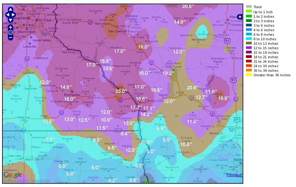 |
| Regional map of 72-hour snowfall totals (Dec. 10-12, 2010). (Click on image to enlarge) | Local map of 72-hour snowfall totals (Dec. 10-12, 2010). (Click on image to enlarge) |
 |
 |
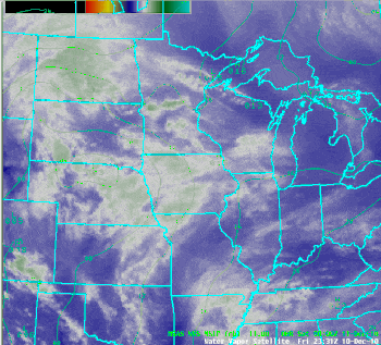
| Satellite loop of the storm from Friday afternoon (Dec 10) through Sunday morning (Dec 12). White/green shades indicate moisture, dark areas indicate drier air. Mean sea-level pressure is also contoured on the image. | Radar loop of the storm from Friday afternoon (Dec 10) through Sunday morning (Dec 12). White/green shades indicated 1"+ per hour snowfall rates or sleet. Mean sea-level pressure is also contoured on the image. |
 |
|
| Peak Winds (MPH) From the Storm |
 |
 |
Snowfall Totals
...DECEMBER 10-11 2010 STORM TOTAL SNOWFALL AMOUNTS...

THESE REPORTS ARE TOTAL AMOUNTS BEGINNING THE AFTERNOON AND EVENING OF
FRIDAY DECEMBER 10TH AND CONTINUING THROUGH THE EARLY MORNING HOURS OF
SUNDAY DECEMBER 12TH.

LOCATION                SNOWFALL            LAT/LON


IOWA

...ALLAMAKEE COUNTY...
WAUKON                    12.0              43.27N 91.48W
LANSING 4SE               10.5              43.32N 91.16W
WATERVILLE                10.0
WAUKON 8NW                 9.3              43.34N 91.6W
DORCHESTER                 8.4              43.47N 91.52W
HARPERS FERRY              7.5              43.20N 91.15W

...CHICKASAW COUNTY...
IONIA                      7.0              43.04N 92.46W
NASHUA                     5.8              42.95N 92.54W

...CLAYTON COUNTY...
 MARQUETTE 3W              8.0              43.04N 91.22W
ELKADER 6SSW               6.6              42.81N 91.43W
STRAWBERRY POINT           6.5              42.68N 91.54W
VOLGA                      5.8              42.81N 91.52W
GUTTENBERG                 2.6              42.79N 91.10W

...FAYETTE COUNTY...
FAYETTE                    6.2              42.83N 91.80W
CLERMONT                   6.2              43.00N 91.65W
WAUCOMA                    5.0              43.05N 92.04W

...FLOYD...
NASHUA 2SW-ISU AG FARM     5.8              42.93N 92.55W
CHARLES CITY               5.0              43.05N 92.67W

...HOWARD COUNTY...
CRESCO 1 NE                9.5              43.38N 92.10W
ELMA                       8.0              43.24N 92.43W

...MITCHELL...
ST ANSGAR                  8.0              43.38N 92.92W

...WINNESHIEK COUNTY...
DECORAH                    9.5              43.31N 91.79W


MINNESOTA

...DODGE COUNTY...
MANTORVILLE               12.0              44.07N 92.76W

...FILLMORE COUNTY...
SPRING VALLEY 3E          12.5              43.68N 92.33W
PETERSON 1S               12.0              43.78N 91.82W
HARMONY                   11.5              43.56N 92.01W
LANESBORO                 10.8              43.72N 91.97W

...HOUSTON...
LA CRESCENT 1N            17.3              43.83N 91.31W
RENO 3SW                  13.7              43.53N 91.33W
CALEDONIA 6S              13.0
LA CRESCENT 9W             9.5              43.82N 91.47W

...MOWER COUNTY...
GRAND MEADOW              13.0              43.70N 92.57W
AUSTIN KAAL TV            12.5              43.68N 92.95W

...OLMSTED COUNTY...
ROCHESTER AIRPORT         16.0              43.91N 92.5W
BYRON                     14.8              44.04N 92.64W

...WABASHA COUNTY...
READS LANDING 1W          17.0              44.40N 92.17W
WABASHA                   15.9              44.38N 92.03W
THEILMAN                  11.7              44.30N 92.2W

...WINONA COUNTY...
WINONA DAM 5A             23.0              44.09N 91.67W
WINONA 3S                 21.0              43.99N 91.61W
MINNESOTA CITY LD5        13.5              44.16N 91.81W
GOODVIEW                  13.5              44.07N 91.71W


WISCONSIN

...ADAMS...
FRIENDSHIP                19.9              43.98N 89.38W

...BUFFALO COUNTY...
MONDOVI 6S                18.0
MONDOVI                   17.0              44.57N 91.67W
ALMA DAM 4                13.5              44.33N 91.93W

...CLARK COUNTY...
OWEN 2N                   14.8              44.95N 90.53W
NEILLSVILLE 3SW           12.0              44.53N 90.64W
ROCK DAM LAKE             11.0              44.73N 90.84W

...CRAWFORD COUNTY...
STEUBEN 4SE               9.0               43.13N 90.84W
SOLDIERS GROVE            5.8               43.40N 90.78W
LYNXVILLE DAM 9           5.0               43.22N 91.10W

...JACKSON COUNTY...
BLACK RIVER FALLS         19.2              44.28N 90.85W
TAYLOR                    13.0              44.32N 91.12W

...JUNEAU COUNTY...
NEW LISBON 2N             12.7              43.90N 90.17W
NECEDAH 2SE               11.8              44.00N 90.04W

...LA CROSSE COUNTY...
HOLMEN 2NW/HOLLAND        20.2              43.97N 91.28W
LA CROSSE WEATHER OFFICE  17.1              43.82N 91.19W
LA CROSSE AIRPORT         16.6              43.88N 91.26W
HOLMEN 2S                 14.2              43.95N 91.26W
LA CROSSE-SOUTH SIDE      15.7

...MONROE COUNTY...
WARRENS 5WSW              20.8              44.10N 90.59W
FOUR CORNERS              18.5              44.07N 90.92W
SPARTA 3S                 12.0              43.92N 90.81W
TUNNEL CITY 1S            11.4              44.01N 90.57W

...RICHLAND COUNTY...
RICHLAND CENTER 1NW       10.5              43.36N 90.42W
RICHLAND CENTER 4N         8.5              43.37N 90.38W

...TAYLOR COUNTY...
MEDFORD                   20.5              45.12N 90.37W
BLAIR 2NW                 15.0
MEDFORD 4NW               14.0              45.16N 90.38W
JUMP RIVER 1NW            10.4

...TREMPEALEAU COUNTY...
OSSEO                     18.0              44.58N 91.22W
GALESVILLE                17.0              44.08N 91.36W
BLAIR                     14.0              44.30N 91.23W

...VERNON COUNTY...
VIOLA                     14.0              43.51N 90.67W
ONTARIO 3E                11.7              43.72N 90.56W
STODDARD 2NE              11.6              43.69N 91.18W
LA FARGE                  11.3              43.57N 90.64W
HILLSBORO                 11.2              43.65N 90.34W
VIROQUA                    8.4              43.54N 90.87W
GENOA DAM 8                7.0              43.57N 91.23W

OBSERVATIONS ARE COLLECTED FROM A VARIETY OF SOURCES WITH VARYING
EQUIPMENT AND EXPOSURE. NOT ALL DATA LISTED IS CONSIDERED OFFICIAL.

FOR THIS...AND A WEALTH OF OTHER RIVER AND WEATHER INFORMATION...
VISIT OUR WEBSITE AT  WEATHER.GOV/LACROSSE

$$
...HIGHEST WIND GUSTS ON DECEMBER 11-12 2010... LOCATION COUNTY WIND GUST ROCHESTER AIRPORT OLMSTED 48 MPH VOLK FIELD JUNEAU 47 MPH AUSTIN MOWER 46 MPH TAMARACK 2NNE TREMPEAULEAU 46 MPH CHARLES CITY FLOYD 45 MPH IONIA 2N CHICKASAW 45 MPH CANTON 2ESE FILLMORE 43 MPH LUBLIN 3NE TAYLOR 43 MPH ROCHESTER KTTC OLMSTED 41 MPH MEDFORD TAYLOR 40 MPH KENDALL MONROE 39 MPH NECEDAH 1WNW JUNEAU 39 MPH NORDNESS 4E WINNESHIEK 39 MPH PLATTEVILLE GRANT 37 MPH PRESTON FILLMORE 37 MPH LA CROSSE AIRPORT LA CROSSE 35 MPH SPARTA MONROE 35 MPH TOMAH 2N MONROE 35 MPH BOSCOBEL GRANT 33 MPH EYOTA 2SE OLMSTED 33 MPH LA CROSSE 1W LA CROSSE 33 MPH BOSCOBEL 1ENE GRANT 32 MPH DECORAH WINNESHIEK 32 MPH DODGE CENTER DODGE 32 MPH GOODVIEW WINONA 32 MPH KELLOGG 2SSE WABASHA 32 MPH VIROQUA VERNON 32 MPH WINONA WINONA 32 MPH ONALASKA 1WSW LA CROSSE 31 MPH PRAIRIE DU CHIEN CRAWFORD 31 MPH RINGE 4WSW OLMSTED 31 MPH EAST DUBUQUE 2NE GRANT 25 MPH LA CROSSE NWS LA CROSSE 25 MPH DE SOTO CRAWFORD 22 MPH
Storm Reports
PRELIMINARY LOCAL STORM REPORT
NATIONAL WEATHER SERVICE LA CROSSE WI
841 AM CST SUN DEC 12 2010

..TIME...   ...EVENT...      ...CITY LOCATION...     ...LAT.LON...
..DATE...   ....MAG....      ..COUNTY LOCATION..ST.. ...SOURCE....
            ..REMARKS..

0457 AM     BLIZZARD         ROCHESTER               44.01N 92.48W
12/12/2010                   OLMSTED            MN   LAW ENFORCEMENT

            MANY ROADS BLOWN SHUT ACROSS OLMSTED COUNTY.SOME VEHICLES
            STRANDED OVERNIGHT WITH OCCUPANTS INSIDE.

0720 AM     BLIZZARD         TOMAH                   43.99N 90.50W
12/12/2010                   MONROE             WI   LAW ENFORCEMENT

            SEVERE DRIFTING REPORTED ACROSS THE COUNTY. A FEW PEOPLE
            STRANDED IN VEHICLES FOR HALF THE NIGHT. ROADWAYS ON
            RIDGE TOPS SEVERLY DRIFTED.

0720 AM     BLIZZARD         LA CROSSE               43.83N 91.23W
12/12/2010                   LA CROSSE          WI   LAW ENFORCEMENT

            SEVERAL VEHICLES STUCK IN SNOW DRIFTS ACROSS THE COUNTY.


0727 AM     BLIZZARD         MAUSTON                 43.80N 90.08W
12/12/2010                   JUNEAU             WI   LAW ENFORCEMENT

            MOST ROADWAYS ACROSS THE COUNTY IMPASSABLE. VEHICLES
            STRANDED ACROSS THE COUNTY.

0727 AM     BLIZZARD         FRIENDSHIP              43.97N 89.82W
12/12/2010                   ADAMS              WI   LAW ENFORCEMENT

            WIDESPREAD DRIFTING ACROSS THE COUNTY WITH MANY ROADWAYS
            IMPASSABLE. SEVERAL VEHICLES STRANDED ACROSS THE COUNTY.


0739 AM     BLIZZARD         VIROQUA                 43.56N 90.89W
12/12/2010                   VERNON             WI   LAW ENFORCEMENT

            SEVERAL ROADS DRIFTED SHUT. WHITEOUT CONDITIONS IN OPEN
            AREAS THROUGH MUCH OF THE NIGHT.

0745 AM     BLIZZARD         PRAIRIE DU CHIEN        43.04N 91.14W
12/12/2010                   CRAWFORD           WI   LAW ENFORCEMENT

            HIGHWAY 27 IMPASSABLE THIS MORNING. SOME POWER LINES DOWN
            ACROSS THE COUNTY.

0752 AM     BLIZZARD         FENNIMORE               42.98N 90.65W
12/12/2010                   GRANT              WI   LAW ENFORCEMENT

            SEVERAL ROADS IMPASSABLE ACROSS THE COUNTY WITH SOME
            STRANDED VEHICLES.


 Follow us on YouTube