On January 28th, a strengthening low pressure system moving northeast across the Dakotas and northern Minnesota brought much above normal temperatures (high temperatures in the 40s) across the Upper Mississippi River Valley Region. At midnight on January 29th, the temperatures still ranged from the mid 30s to lower 40s. Then a very drastic weather change came about as a very strong arctic cold front moved across the area during the morning of January 29th. This brought dangerous winter weather conditions to the region, in the form of snow, strong winds, blowing snow and blizzards, along with bitterly cold temperatures and wind chills.
 During the morning hours on January 29th, the front had moved from eastern Minnesota and eastern Iowa, into eastern Wisconsin and northwest Illinois. This front brought a switch in wind direction from south to northwest and temperatures began to drop. However, the coldest air and strongest winds lagged behind the front by about 100 miles. As the day progressed the entire system moved east and temperatures dropped at a rate of 2 to 5 degrees per hour. By 10:00 PM, actual temperatures in the local area ranged from around 10 degrees below zero in parts of southeast Minnesota to around zero in southeast Wisconsin.
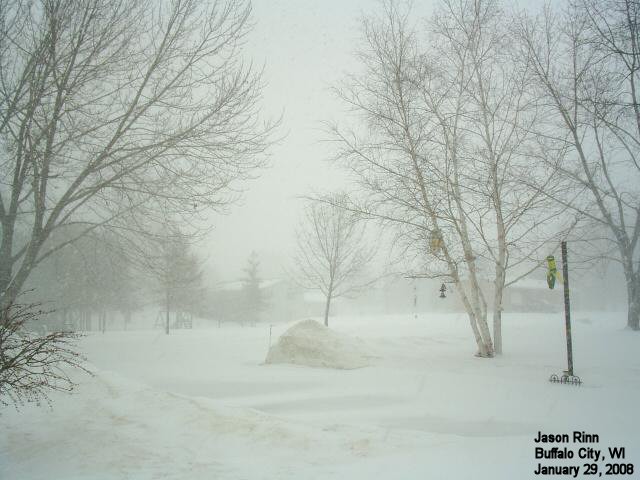
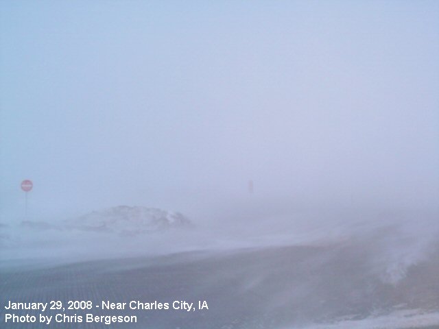 As the temperatures dropped, northwest winds increased and by mid morning were blowing at 20 to 30 miles per hour. These winds combined with the cold temperatures to cause wind chills during the day from the teens below zero to around 35 degrees below zero. The strong winds also caused problems when an area of moderate to heavy snow moved from Iowa across southeast Minnesota and into central Wisconsin. While accumulations were not significant, generally in the 1 to 4 inch range, blowing snow brought blizzard conditions along a narrow corridor from north central Iowa through parts of southeast Minnesota into west central Wisconsin. Visibilities in these areas dropped down to zero at times, and combined with the very cold wind chills, created dangerous situations for anyone traveling or just being outside in general.
The winds strengthened even further during the late afternoon as the strong low pressure system moved northeast across northern Illinois and Lake Michigan. At 4 PM, Chicago reported a barometric pressure reading of 29.06 inches. This was their lowest pressure reading since January 10, 1975 (33 years). The tight surface pressure gradient associated with this low pressure area caused the winds to increase into the 25 to 35 mph range from the afternoon of January 29th into the early morning hours of January 30th. During this same time period, the winds gusted up into the 35 to 50 mph range.
On January 29th, an arctic cold front moved through southeast Minnesota and northeast Iowa between 1:00 AM and 5:00 AM, and through western Wisconsin between 5:00 AM and 10:00 AM. The temperatures behind this cold front dropped between 2 and 5 degrees per hour through the morning and afternoon. By 4 PM, temperatures had dropped between 30 and 45 degrees from their early morning high temperatures. These temperatures would continue to drop about another ten degrees through midnight. For the calendar day, the temperature drop ranged from 41 degrees at Oelwein, IA to 56 degrees at Winona State University in Winona, MN. The last time that the area saw a temperature change this great on a calendar day was January 18, 1996.
The table below provides the temperature change on January 29th.
Temperature Change on January 29, 2008
In Northeast Iowa...
Temp High Low
Location County Fall Temp Temp
-------- ------ ---- ---- ----
Cresco KIMT Howard 53 40 -13
Crestwood AWS Howard 52 41 -11
Decorah AWOS Winneshiek 51 43 -8
Turkey Valley AWS Chickasaw 50 39 -11
Osage - KIMT Mitchell 49 39 -10
New Hampton AWS Chickasaw 48 36 -12
Riceville - KIMT Howard 48 37 -11
Charles City AWOS Floyd 43 37 -6
Oelwein AWOS Fayette 41 37 -4
In Southeast Minnesota...
Temp High Low
Location County Fall Temp Temp
-------- ------ ---- ---- ----
WSU Campus Winona 56 43 -13
Rochester Kellogg - KIMT Olmsted 55 40 -15
Willow Creek - KIMT Olmsted 55 41 -14
Century High School AWS Olmsted 54 37 -17
Preston KIMT Fillmore 54 41 -13
Rochester Lincoln AWS Olmsted 54 38 -16
Plainview AWS Wabasha 53 37 -16
St Charles 4W RWIS Olmsted 53 40 -13
Grand Meadow - KIMT Mower 52 37 -15
Preston AWOS Fillmore 52 41 -11
Rochester ASOS Olmsted 52 40 -12
Winona AWOS Winona 52 43 -9
Austin KIMT Mower 51 37 -14
Byron/Kasson RWIS Dodge 50 37 -13
West Concord - KIMT Dodge 50 35 -15
Austin AWOS Mower 48 39 -9
Albert Lea - KIMT Freeborn 48 38 -10
Dexter RWIS Mower 48 36 -12
Dodge Center AWOS Dodge 48 37 -11
In Western Wisconsin...
Temp High Low
Location County Fall Temp Temp
-------- ------ ---- ---- ----
Richland Center AWS Richland 55 42 -13
Wisc Dells AWOS Sauk 54 43 -11
Alma AWS Buffalo 53 37 -16
Fennimore Elementary AWS Grant 53 41 -12
Friendship AWS Adams 53 39 -14
La Crosse ASOS La Crosse 53 43 -10
Prairie Du Chien AWS Crawford 53 43 -10
Riverdale School AWS Grant 53 42 -11
Arcadia Hill RWIS Trempealeau 52 40 -12
Black River Falls RAWS Jackson 52 40 -12
La Crosse - NWS La Crosse 52 40 -12
Loyal School AWS Clark 52 38 -14
Tomah 4N RWIS Monroe 52 43 -9
Jackson Pass 5W Tomah RWIS Monroe 51 42 -9
Mount Sterling 1S RWIS Crawford 51 41 -10
Necedah RAWS Juneau 51 42 -9
Dickeyville RWIS Grant 50 45 -5
Boscobel ASOS Grant 49 43 -6
Prairie Du Chien AWOS Crawford 49 41 -8
Sparta AWOS Monroe 49 41 -8
Stanley 1 SE RWIS Chippewa 49 37 -12
Medford AWOS Taylor 48 37 -11
La Crosse, WI saw the temperature drop from a high temperature of 43 degrees at 2:03 AM to a low temperature of -10 degrees at 11:49 PM. This 53 degree temperature change tied February 17, 1874 for the largest temperature change during a calendar day.
Rochester, MN fell from 40 degrees at 12:01 AM to -12 degrees at 11:13 PM. This 52 degree drop tied January 20, 1937 and February 23, 1918 for their sixth largest temperature change in a calendar day. It was their largest change in temperature since January 18, 1996 when the temperature fell 50 degrees. Their largest temperature difference ever recorded was 58 degrees on May 5, 1909.
The image below provides the hourly temperature fall at Rochester International Airport, La Crosse Municipal Airport, and Necedah Wildlife Reserve.

Behind the arctic cold front during the morning of January 29th, the northwest winds increased into the 20 to 30 mph range. This caused considerable blowing and drifting of the snow in southeast Minnesota and parts of northeast Iowa and west central Wisconsin. Blizzard conditions existed in these areas during the late morning and afternoon. These winds increased into the 25 to 35 mph range during the late afternoon and continued into the early morning hours of January 30th. It was during this time that many of the peak wind gusts were reported. The table below lists the peak wind gusts from the afternoon of January 29th through the morning of January 30th.
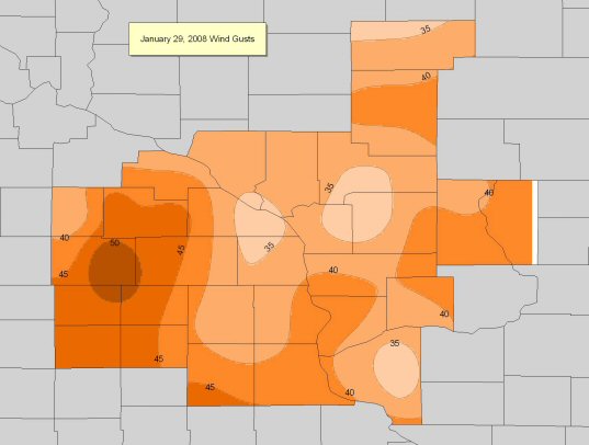
Peak Wind Gusts
IN NORTHEAST IOWA...
STATION                   COUNTY             TIME     GUST
-------                   ------             ----     ----
OELWEIN AWOS              FAYETTE           255 PM   47 MPH
CHARLES CITY AWOS         FLOYD             715 PM   45 MPH
DECORAH AWOS              WINNESHIEK        755 PM   36 MPH

IN SOUTHEAST MINNESOTA...

STATION                   COUNTY             TIME     GUST
-------                   ------             ----     ----
DEXTER RWIS               MOWER             726 PM   53 MPH
BYRON/KASSON RWIS         DODGE             259 PM   46 MPH
ST CHARLES 4W RWIS        OLMSTED           621 PM   46 MPH
ROCHESTER ASOS            OLMSTED           654 PM   46 MPH
PRESTON AWOS              FILLMORE          715 PM   44 MPH
DODGE CENTER AWOS         DODGE             515 PM   38 MPH
WINONA AWOS               WINONA            217 PM   33 MPH

IN WESTERN WISCONSIN...

STATION                   COUNTY             TIME     GUST
-------                   ------             ----     ----
VOLK FIELD                JUNEAU           1123 PM   43 MPH
MOUNT STERLING 1S RWIS    CRAWFORD         1008 PM   43 MPH
PRAIRIE DU CHIEN AWOS     CRAWFORD          455 PM   41 MPH
STANLEY 1 SE RWIS         CHIPPEWA         1003 PM   39 MPH
TOMAH 4N RWIS             MONROE            907 PM   39 MPH
ARCADIA HILL RWIS         TREMPEALEAU       710 PM   38 MPH
NECEDAH RAWS              JUNEAU            848 PM   38 MPH
MEDFORD AWOS              TAYLOR            755 PM   38 MPH
DICKEYVILLE RWIS          GRANT             803 PM   36 MPH
LA CROSSE ASOS            LA CROSSE         853 PM   36 MPH
BOSCOBEL ASOS             GRANT             817 PM   36 MPH
JACKSON PASS 5W TOMAH     MONROE            909 PM   35 MPH
WISC DELLS AWOS           SAUK             1035 PM   35 MPH
SPARTA AWOS               MONROE            835 PM   33 MPH

KEY TO OBSERVATION TYPES
AWS - SENSORS FROM AWS INCORPORATED. OFTEN LOCATED AT SCHOOLS.
RWIS - ROAD WEATHER INFORMATION SYSTEMS. LOCATED ON MAJOR ROADS AND BRIDGES.
RAWS - FIRE WEATHER OBSERVATIONS. OFTEN LOCATED IN FORESTS.
ASOS/AWOS - AVIATION WEATHER OBSERVATIONS. LOCATED AT AIRPORTS.
OBSERVATIONS ARE COLLECTED FROM A VARIETY OF SOURCES WITH VARYING EQUIPMENT
AND EXPOSURE.  NOT ALL DATA LISTED IS CONSIDERED OFFICIAL.
Very dangerous wind chills developed across southeast Minnesota, northeast Iowa, and western Wisconsin during the early evening of January 29th and continued through the morning of January 30th. Wind chills generally ranged from 30 to 45 degrees below zero. The table below provides the lowest wind chills from the afternoon of January 29th through the morning of January 30th.
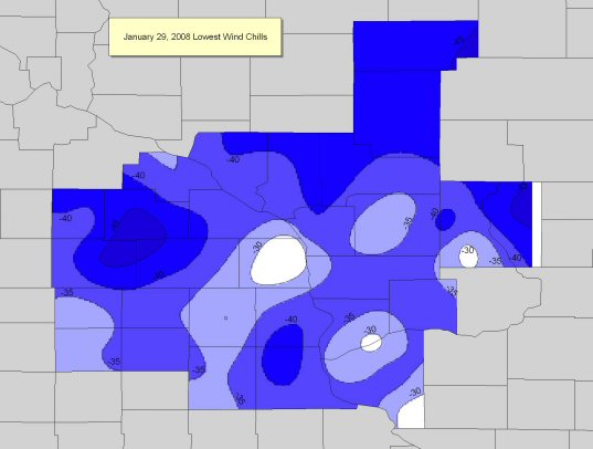
Lowest Wind Chills
IN NORTHEAST IOWA...
STATION COUNTY TIME WIND CHILL
------- ------ ---- ----------
MFL MARMAC ES/HS MONONA CLAYTON 859 PM -43 F
NEW HAMPTON AWS CHICKASAW 1114 PM -37 F
TURKEY VALLEY AWS CHICKASAW 844 PM -37 F
RICEVILLE - KIMT HOWARD 816 PM -36 F
CRESTWOOD AWS HOWARD 1014 PM -35 F
CHARLES CITY AWOS FLOYD 955 PM -35 F
OELWEIN AWOS FAYETTE 835 PM -33 F
OSAGE - KIMT MITCHELL 756 PM -32 F
DECORAH AWOS WINNESHIEK 955 PM -30 F
IN SOUTHEAST MINNESOTA...
STATION COUNTY TIME WIND CHILL
------- ------ ---- ----------
CENTURY HIGH SCHOOL AWS OLMSTED 1014 PM -46 F
GRAND MEADOW - KIMT MOWER 855 PM -46 F
DEXTER RWIS MOWER 721 PM -45 F
ST CHARLES 4W RWIS OLMSTED 856 PM -43 F
WEST CONCORD - KIMT DODGE 835 PM -42 F
PRESTON KIMT FILLMORE 915 PM -40 F
JOHN ADAMS - KIMT OLMSTED 936 PM -40 F
PRESTON AWOS FILLMORE 1135 PM -40 F
AUSTIN AWOS MOWER 756 PM -39 F
AUSTIN KIMT MOWER 756 PM -39 F
DODGE CENTER AWOS DODGE 755 PM -38 F
ROCHESTER LINCOLN AWS OLMSTED 900 PM -37 F
WSU CAMPUS WINONA 1144 PM -37 F
PLAINVIEW AWS WABASHA 914 PM -36 F
WINONA AWOS WINONA 957 PM -33 F
3N LA CRESCENT APRS HOUSTON 232 AM -29 F
IN WESTERN WISCONSIN...
STATION COUNTY TIME WIND CHILL
------- ------ ---- ----------
FRIENDSHIP AWS ADAMS 559 AM -44 F
MEDFORD AWOS TAYLOR 1255 AM -44 F
STANLEY 1 SE RWIS CHIPPEWA 403 AM -43 F
LOYAL SCHOOL AWS CLARK 1229 AM -43 F
VOLK FIELD JUNEAU 130 AM -41 F
NECEDAH RAWS JUNEAU 248 AM -39 F
ALMA AWS BUFFALO 944 PM -39 F
ARCADIA HILL RWIS TREMPEALEAU 710 AM -38 F
BUFFALO LUTHERAN AWS BUFFALO 244 AM -38 F
RICHLAND CENTER AWS RICHLAND 314 AM -38 F
FENNIMORE ELEMENTARY AWS GRANT 129 AM -37 F
MOUNT STERLING 1S RWIS CRAWFORD 208 AM -37 F
TOMAH 4N RWIS MONROE 1107 PM -35 F
LA CROSSE ASOS LA CROSSE 1253 AM -35 F
RIVERDALE SCHOOL AWS GRANT 1214 AM -35 F
PRAIRIE DU CHIEN AWOS CRAWFORD 1235 AM -35 F
PRAIRIE DU CHIEN AWS CRAWFORD 814 PM -33 F
SPARTA AWOS MONROE 135 AM -33 F
MAUSTON APRS JUNEAU 232 AM -30 F
LA CROSSE 1S GUND LUTH LA CROSSE 146 AM -30 F
BOSCOBEL ASOS GRANT 1253 AM -29 F
DICKEYVILLE RWIS GRANT 1103 PM -28 F
1 SE DOWNTOWN ONALASKA LA CROSSE 342 AM -28 F
KEY TO OBSERVATION TYPES
AWS - SENSORS FROM AWS INCORPORATED. OFTEN LOCATED AT SCHOOLS.
RWIS - ROAD WEATHER INFORMATION SYSTEMS. LOCATED ON MAJOR ROADS AND BRIDGES.
RAWS - FIRE WEATHER OBSERVATIONS. OFTEN LOCATED IN FORESTS.
ASOS/AWOS - AVIATION WEATHER OBSERVATIONS. LOCATED AT AIRPORTS.
OBSERVATIONS ARE COLLECTED FROM A VARIETY OF SOURCES WITH VARYING EQUIPMENT
AND EXPOSURE. NOT ALL DATA LISTED IS CONSIDERED OFFICIAL.
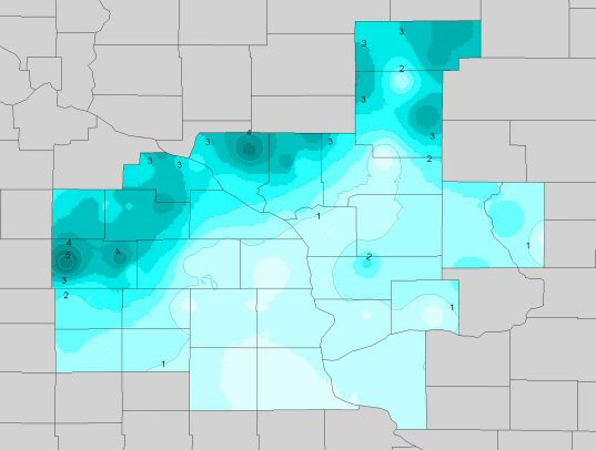
Moderate to heavy snow developed behind the arctic cold front across southeast Minnesota and west central and north central Wisconsin on the morning of January 29th and continued into the afternoon. Snow rates up to an inch per hour were reported at times. Between 2 and 5 inches of snow fell northeast of a Grand Meadow, MN to Neillsville, WI line. This snow, combined with strong winds resulted in blizzard conditions developing across much of southeast Minnesota and Buffalo County in west central Wisconsin. Another band of snow move across the area from the mid afternoon through the evening of January 29th, which produced amounts generally less than an inch across northeast Iowa and the remainder of western Wisconsin. The map below illustrates how much snow fell across the region.


 Follow us on YouTube