Overview
|
A dangerously cold arctic air mass settled across the Upper Mississippi River Valley for the end of January 2019, in the wake of a winter storm that brought several inches of snow a day earlier. The record-breaking cold (coldest since 1996) moved in Monday afternoon (the 28th), with the temperatures dropping below zero by early evening. Temperatures would not climb above zero (0 deg F) until later Friday morning (Feb 1st) - one of the longest stretches of sub-zero temperatures on record. What made this air more dangerous, to deadly, was the addition of strong, gusty winds. Northwest winds were on the increase by early morning on the 29th (Tuesday), blowing from 15 to 25 mph with gusts upwards of 40 through that day. Wind chills from -30 to -60 F resulted. Winds would diminish a bit Wednesday (30th), eventually becoming light that night. Low temperatures bottomed out around 30 below for most Wednesday morning. Even colder readings were observed Thursday morning as clear skies and light winds allowed temperatures to fall to -40 or colder in some areas. Most schools closed through the week, first for the snow storm on Monday, then for the dangerous cold Tuesday through Thursday. A state of emergency was declared for Wednesday, Jan.30th by the Wisconsin Governor resulting in many businesses being closed and suspension of postal services. Tragically, the cold also resulted in some loss of life.
|
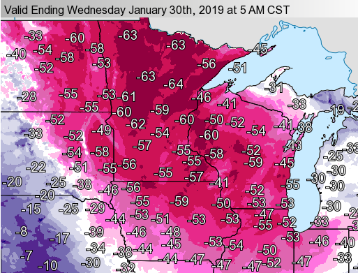 Wind chills from 5 am Wed, Jan 30th |
Temperatures / Wind Chill
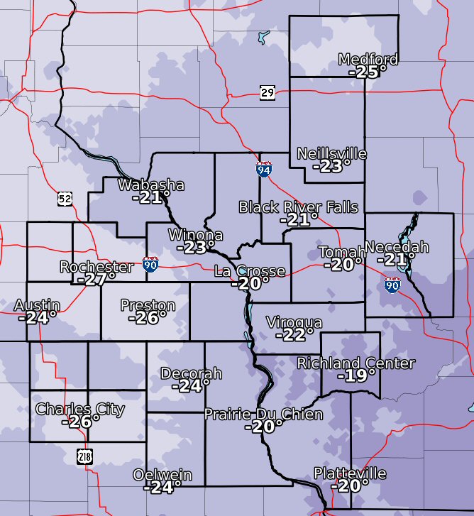
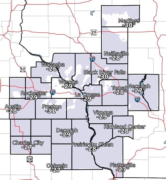
High/Low Temperatures Maps
(map temps are approx and not official readings - more specifics in tables below)
 |
 |
 |
| Tue Highs (occurred at midnight Tue morning) |
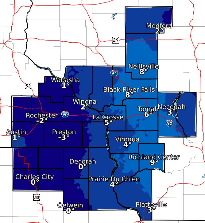
Wed Highs |
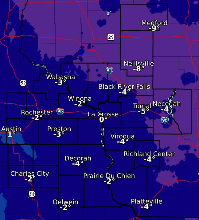
Thu Highs (likely occurred at midnight Thu) |
 |
 |
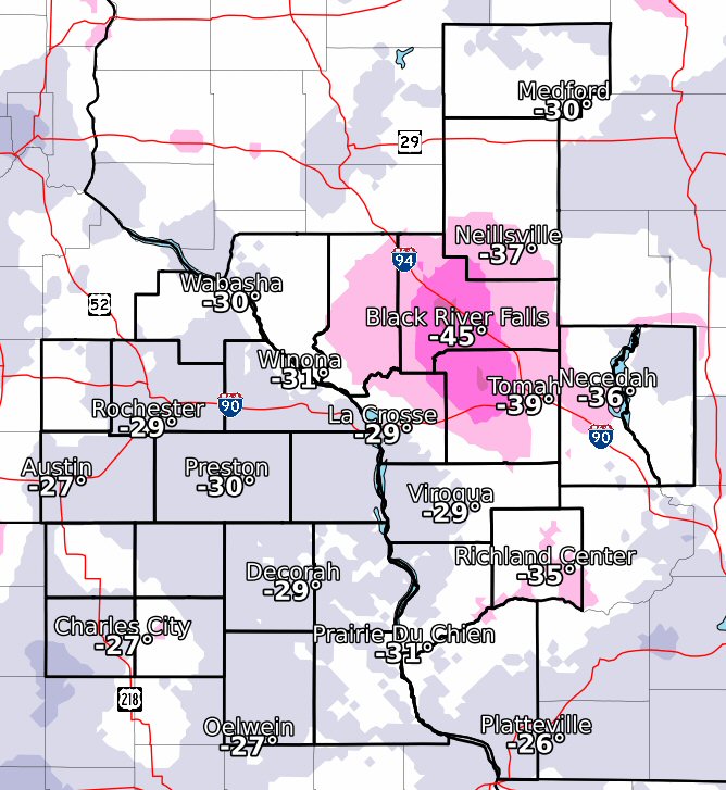 |
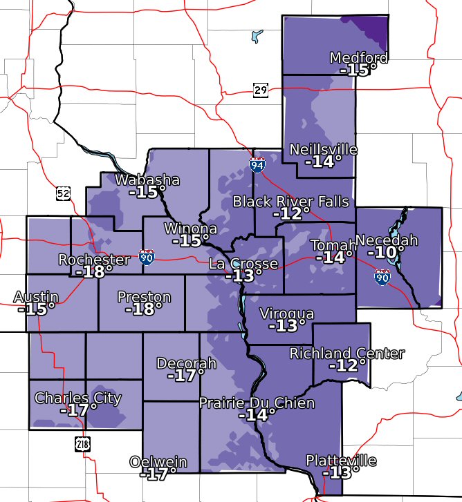
| Tue Lows (occurred just before midnight Tue evening) |
Wed Lows |
Thu Lows |
Coldest Wind Chills: Jan 29-31
....COLDEST WIND CHILL REPORTS... Location Temp Time/Date 1 ENE Dexter -63 F 0240 AM 01/30 1 E Ridgeway -63 F 0540 AM 01/30 3 N Stewartville -62 F 0320 AM 01/30 2 SE Eyota -61 F 0210 AM 01/30 Rochester International Airp -61 F 0354 AM 01/30 Charles City Airport -60 F 1155 PM 01/29 2 E Kasson -60 F 1040 PM 01/29 Preston Airport -59 F 0436 AM 01/30 2 ESE Canton -59 F 0410 AM 01/30 Dodge Center Airport -59 F 0435 AM 01/30 Mayo Helipad -58 F 0115 AM 01/30 2 W Oelwein -58 F 0115 AM 01/30 Monona -58 F 0239 AM 01/30 Oelwein Municipal Airport -58 F 0115 AM 01/30 2 N Ionia -58 F 1200 AM 01/30 Byron -57 F 0201 AM 01/30 Medford Airport -57 F 0715 AM 01/30 2 NNW Zumbro Falls -56 F 0443 AM 01/30 1 ENE Jackson Junction -56 F 0230 AM 01/30 Austin Municipal Airport -55 F 0435 AM 01/30 1 SSE Kellogg -55 F 0515 AM 01/30 New Hampton -55 F 0829 AM 01/30 Platteville Municipal Airpor -55 F 0715 AM 01/30 Saint Charles -55 F 0335 AM 01/30 Viroqua Municipal Airport -55 F 0555 AM 01/30 Black River Falls Area Airpo -54 F 0935 PM 01/30 Decorah -54 F 0215 AM 01/30 Fennimore -54 F 0840 AM 01/30 Decorah Municipal Airport -53 F 0235 AM 01/30 3 NE Riceville -53 F 0915 AM 01/30 Loyal -53 F 0314 AM 01/30 Volk Field -53 F 0856 AM 01/30 3 W Saint Joseph -52 F 0509 AM 01/30 Cochrane -52 F 0924 AM 01/30 3 NE Lublin -52 F 0814 AM 01/30 Prairie Du Chien Airport -52 F 0315 AM 01/30 Mauston Airport -51 F 0915 AM 01/30 Saint Ansgar -51 F 0125 AM 01/30 Sparta/Fort McCoy Airport -50 F 0515 AM 01/30 Necedah -50 F 0648 AM 01/30 Plainview -49 F 0428 AM 01/30 La Crosse Regional Airport -49 F 0453 AM 01/30 2 E Cataract -48 F 0423 AM 01/30 1 E Black River Falls -48 F 0615 AM 01/30 Hayfield -48 F 1217 AM 01/30 4 ESE Douglas -47 F 0916 AM 01/30 2 NNE Rochester -47 F 0905 AM 01/30 Mcgregor -47 F 0919 AM 01/30 1 ENE Boscobel -46 F 0303 AM 01/30 Wabasha -46 F 0716 AM 01/30 Boscobel Airport -46 F 0853 AM 01/30 Plainview -46 F 0824 AM 01/30 Mauston -45 F 0912 AM 01/30 2 SE Douglas -44 F 0300 AM 01/30 4 SSE Mound Prairie -44 F 0610 AM 01/30 Eyota 2NE -44 F 0700 AM 01/31 1 WSW Onalaska -43 F 0120 AM 01/30 De Soto -43 F 0935 AM 01/30 3 SW Hammond -43 F 0130 AM 01/30 Mazeppa -42 F 1130 PM 01/29 Chelsea -41 F 0615 AM 01/30 Lynxville Dam 9 -40 F 0930 AM 01/30 3 ESE Douglas -36 F 0310 AM 01/30 2 NE Rochester -36 F 0830 AM 01/30 Lake City -34 F 0646 AM 01/30 Observations are collected from a variety of sources with varying equipment and exposures. We thank all volunteer weather observers for their dedication. Not all data listed are considered official.
High/Low Temperatures Wed (Jan 30th)
| State | Location | County | High | Low |
| IA | NEW HAMPTON | Chickasaw | -6 | -29 |
| IA | CHARLES CITY | Floyd | -17 | -28 |
| IA | OSAGE | Mitchell | -6 | -28 |
| IA | NORTHEAST IOWA REGIONAL AIRPORT | Floyd | -17 | -27 |
| IA | ELKADER 6 SSW | Clayton | -2 | -27 |
| IA | FAYETTE | Fayette | -5 | -29 |
| IA | OELWEIN MUNICIPAL AIRPORT | Fayette | -17 | -27 |
| IA | DECORAH | Winneshiek | -6 | -28 |
| IA | CRESCO 1 NE | Howard | -3 | -29 |
| IA | POSTVILLE | Allamakee | -3 | -28 |
| IA | DECORAH MUNICIPAL AP | Winneshiek | -17 | -27 |
| IA | WAUKON 4SW | Allamakee | -5 | -40 |
| IA | GUTTENBERG L AND D 10 | Clayton | 15 | -26 |
| MN | AUSTIN WASTE WATER TREATMENT FACILITY | Mower | -7 | -30 |
| MN | AUSTIN MUNICIPAL AIRPORT | Mower | -15 | -26 |
| MN | GRAND MEADOW | Mower | -5 | -29 |
| MN | THEILMAN 1SSW | Wabasha | -8 | -29 |
| MN | ROCHESTER INTL AP | Olmsted | -19 | -29 |
| MN | PRESTONE FILLMORE COUNTY AIRPORT | Fillmore | -19 | -30 |
| MN | LA CRESCENT DAM 7 | Winona | -3 | -24 |
| MN | MABEL | Fillmore | -4 | -29 |
| MN | CALEDONIA | Houston | -5 | -29 |
| MN | PRESTON | Fillmore | -4 | -30 |
| MN | WINONA DAM 5 A | Winona | -2 | -27 |
| MN | MINNESOTA CITY DAM 5 | Winona | -10 | -27 |
| WI | MATHER 3 NW | Jackson | -7 | -43 |
| WI | HILLSBORO 2SW | Vernon | -3 | -29 |
| WI | NEILLSVILLE 3ESE | Clark | -3 | -28 |
| WI | MEDFORD | Taylor | -4 | -31 |
| WI | MEDFORD TAYLOR COUNTY AP | Taylor | -14 | -30 |
| WI | FRIENDSHIP | Adams | -1 | -27 |
| WI | PRAIRIE DU CHIEN | Crawford | 1 | -25 |
| WI | STEUBEN 4 SE | Crawford | 3 | -28 |
| WI | LYNXVILLE DAM 9 | Crawford | 14 | -28 |
| WI | VIROQUA | Vernon | -4 | -31 |
| WI | GENOA DAM 8 | Vernon | -1 | -23 |
| WI | PRAIRIE DU CHIEN MUNICIPAL AIRPORT | Crawford | -14 | -26 |
| WI | SPARTA | Monroe | -3 | -28 |
| WI | LA CROSSE MUNICIPAL AP | La Crosse | -12 | -26 |
| WI | SPARTA FORT MCCOY | Monroe | -13 | -28 |
| WI | LA CROSSE WFO | La Crosse | -15 | -31 |
| WI | CASHTON 3NNW | Monroe | -2 | -30 |
| WI | BOSCOBEL AIRPORT | Grant | -11 | -26 |
| WI | MAUSTON 1 SE | Juneau | 0 | -28 |
| WI | TREMPEALEAU DAM 6 | Trempealeau | -3 | -26 |
| WI | ALMA DAM 4 | Buffalo | -4 | -27 |
| WI | LANCASTER 4 WSW | Grant | -3 | -29 |
High/Low Temperatures Thu (Jan 31st)
| State | Location | County | High | Low |
| IA | NEW HAMPTON | Chickasaw | -16 | -29 |
| IA | SUMNER | Fayette | -35 | |
| IA | CHARLES CITY | Floyd | -3 | -33 |
| IA | OSAGE | Mitchell | -17 | -29 |
| IA | NORTHEAST IOWA REGIONAL AIRPORT | Floyd | -2 | -29 |
| IA | ELKADER 6 SSW | Clayton | -15 | -41 |
| IA | ELKADER | Clayton | -34 | |
| IA | FAYETTE | Fayette | -18 | -32 |
| IA | OELWEIN MUNICIPAL AIRPORT | Fayette | -2 | -27 |
| IA | DECORAH | Winneshiek | -6 | -37 |
| IA | WAUKON 5 SE | Allamakee | -37 | |
| IA | DECORAH MUNICIPAL AP | Winneshiek | -4 | -29 |
| IA | GUTTENBERG L AND D 10 | Clayton | -11 | -30 |
| IA | WADENA | Fayette | -35 | |
| MN | LA CRESCENT DAM 7 | Winona | -12 | -30 |
| MN | AUSTIN WASTE WATER TREATMENT FACILITY | Mower | -18 | -33 |
| MN | AUSTIN MUNICIPAL AIRPORT | Mower | 1 | -27 |
| MN | GRAND MEADOW | Mower | -18 | -31 |
| MN | THEILMAN 1SSW | Wabasha | -15 | -41 |
| MN | ROCHESTER INTL AP | Olmsted | -3 | -30 |
| MN | PRESTONE FILLMORE COUNTY AIRPORT | Fillmore | -4 | -31 |
| MN | MABEL | Fillmore | -5 | -37 |
| MN | WYKOFF 3 NW | Fillmore | -39 | |
| MN | CHATFIELD | Fillmore | -39 | |
| MN | CALEDONIA | Houston | -15 | -29 |
| MN | MOUND PRAIRIE | Houston | -37 | |
| MN | LA CRESCENT 1 NNW | Houston | -36 | |
| MN | PRESTON | Fillmore | -17 | -44 |
| MN | RUSHFORD | Fillmore | -16 | -40 |
| MN | WINONA DAM 5 A | Winona | -13 | -32 |
| MN | WINONA | Winona | -30 | |
| MN | MINNESOTA CITY DAM 5 | Winona | -6 | -32 |
| WI | PRAIRIE DU CHIEN | Crawford | -14 | -29 |
| WI | STEUBEN 4 SE | Crawford | -14 | -29 |
| WI | LYNXVILLE DAM 9 | Crawford | -11 | -33 |
| WI | VIROQUA | Vernon | -17 | -31 |
| WI | GENOA DAM 8 | Vernon | -15 | -30 |
| WI | GAYS MILLS | Crawford | -13 | -45 |
| WI | PRAIRIE DU CHIEN MUNICIPAL AIRPORT | Crawford | -2 | -32 |
| WI | LA CROSSE MUNICIPAL AP | La Crosse | -1 | -33 |
| WI | SPARTA FORT MCCOY | Monroe | -3 | M |
| WI | LA CROSSE WFO | La Crosse | -6 | -29 |
| WI | CASHTON 3NNW | Monroe | -14 | -40 |
| WI | BOSCOBEL AIRPORT | Grant | -2 | -36 |
| WI | MAUSTON 1 SE | Juneau | -11 | -34 |
| WI | MATHER 3 NW | Jackson | -16 | -45 |
| WI | TOMAH | Monroe | -31 | |
| WI | HOLMEN 4 NW | La Crosse | -37 | |
| WI | HILLSBORO 2SW | Vernon | -13 | -40 |
| WI | GILLINGHAM | Richland | -38 | |
| WI | NEILLSVILLE 3ESE | Clark | -13 | -33 |
| WI | WEST SALEM 2 W | La Crosse | -40 | |
| WI | MEDFORD | Taylor | -13 | -32 |
| WI | MEDFORD TAYLOR COUNTY AP | Taylor | -10 | -30 |
| WI | FRIENDSHIP | Adams | -10 | -36 |
| WI | TREMPEALEAU DAM 6 | Trempealeau | -14 | -35 |
| WI | ALMA DAM 4 | Buffalo | -11 | -29 |
| WI | LANCASTER 4 WSW | Grant | -16 | -28 |
Observations are collected from a variety of sources with varying equipment and exposures. We thank all volunteer weather observers for their dedication. Not all data listed are considered official.
Photos & Video:
Environment
Insert synoptic summary.
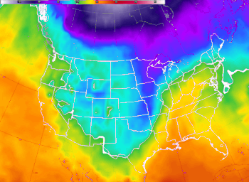 |
| Figure 1: 850 mb temperatures (Jan29-31). Dark purple to white are -30 C or colder. |
 |
Media use of NWS Web News Stories is encouraged! Please acknowledge the NWS as the source of any news information accessed from this site. |
|


 Follow us on YouTube