Overview
|
Strong to severe storms developed across parts of southeast Minnesota into western Wisconsin during the evening of July 18th, and continued into the morning hours of July 19th. The slow moving storms produced sporadic damage, at least 1 tornado, and torrential rain. Flash flooding was probably the biggest impact from the storms, with 4 to 6 inches of rain falling across a relatively narrow axis. This led to mudslides, damaged roads, and rapid rises on area rivers and creeks. |
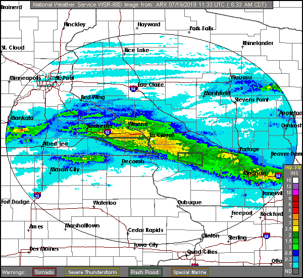 Radar estimated rainfall from July 18-19, 2019 |
Tornadoes:
|
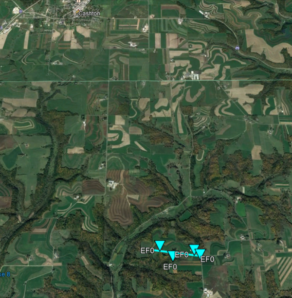
Tornado - Westby 5NE
|
||||||||||||||||
The Enhanced Fujita (EF) Scale classifies tornadoes into the following categories:
| EF0 Weak 65-85 mph |
EF1 Moderate 86-110 mph |
EF2 Significant 111-135 mph |
EF3 Severe 136-165 mph |
EF4 Extreme 166-200 mph |
EF5 Catastrophic 200+ mph |
 |
|||||
Flooding
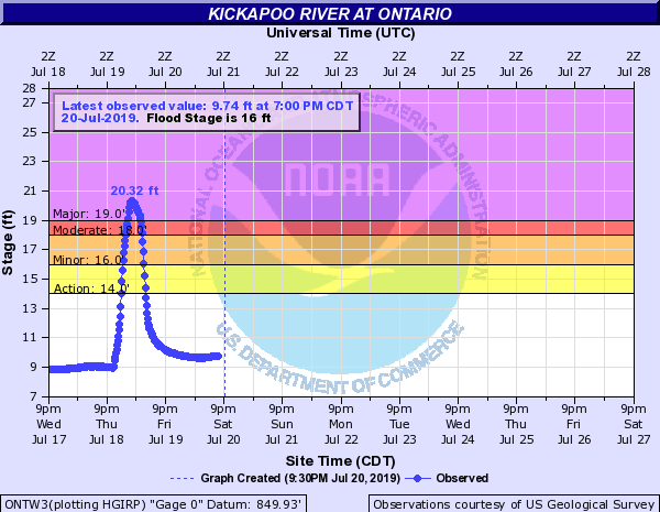
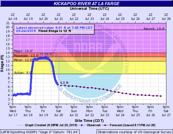
Hydrographs
 |
 |
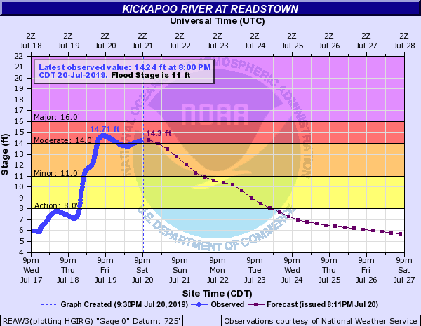 |
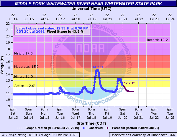
| Kickapoo River at Ontario | Kickapoo River at La Farge | Kickapoo River at Readstown |
 |
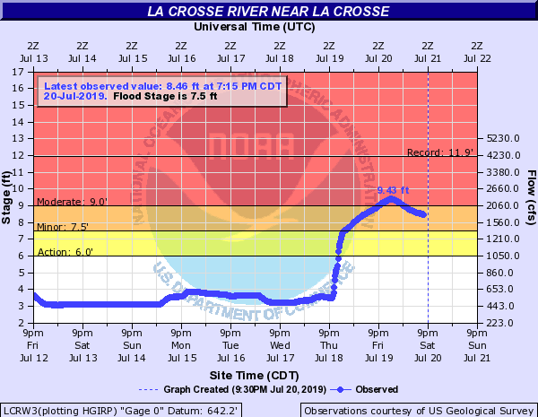 |
| Middle Fork Whitewater River at Whitewater State Park | La Crosse River at La Crosse |
Photos:
 |
 |
 |
 |
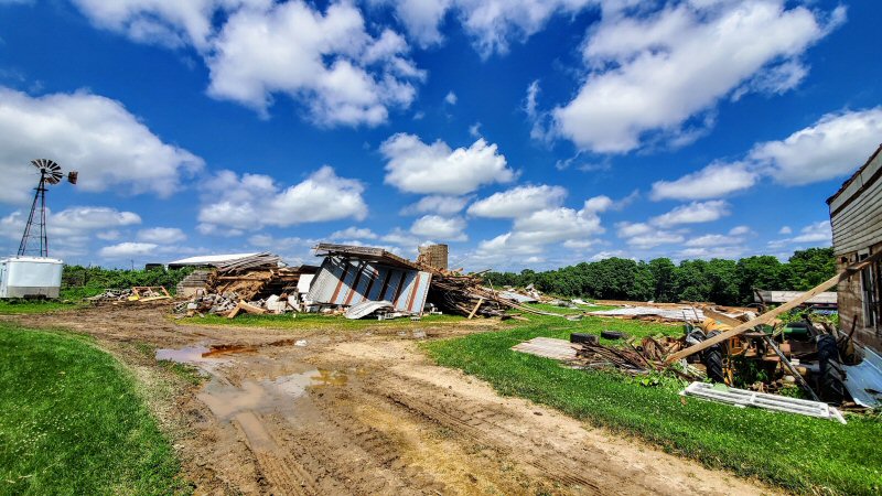
| Barn completely destroyed by tornado (Photo by Dave Lawrence) |
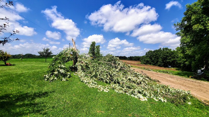
Tree damage near residence caused by EF-0 tornado (Photo by Dave Lawrence) |
Additional tree damage near residence along Wang Ridge Rd (Photo by Dave Lawrence) |
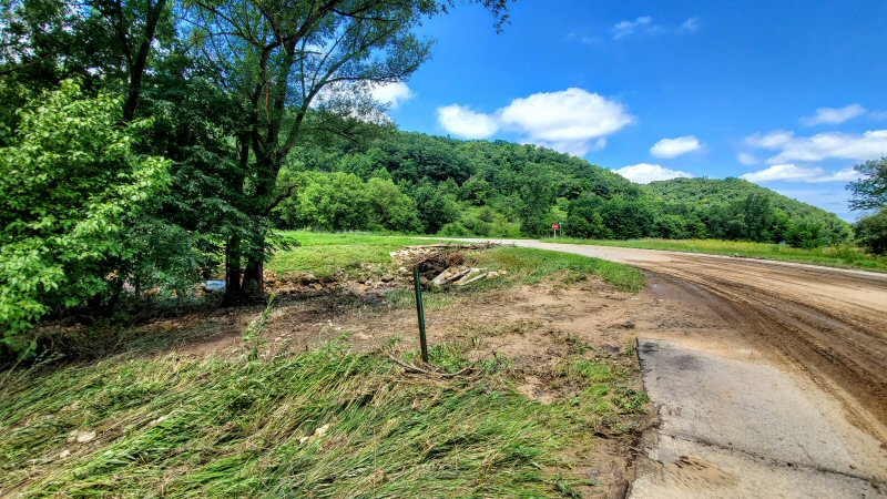
Evidence of significant water/flooding near Highway 27 near Cashton (Photo by Dave Lawrence) |
 |
|||
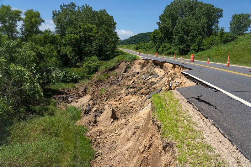
| County Road 21 partially washed out east of Mount Prairie by flooding (Photo by Alan Stankevitz) |
Radar:
 |
 |
||
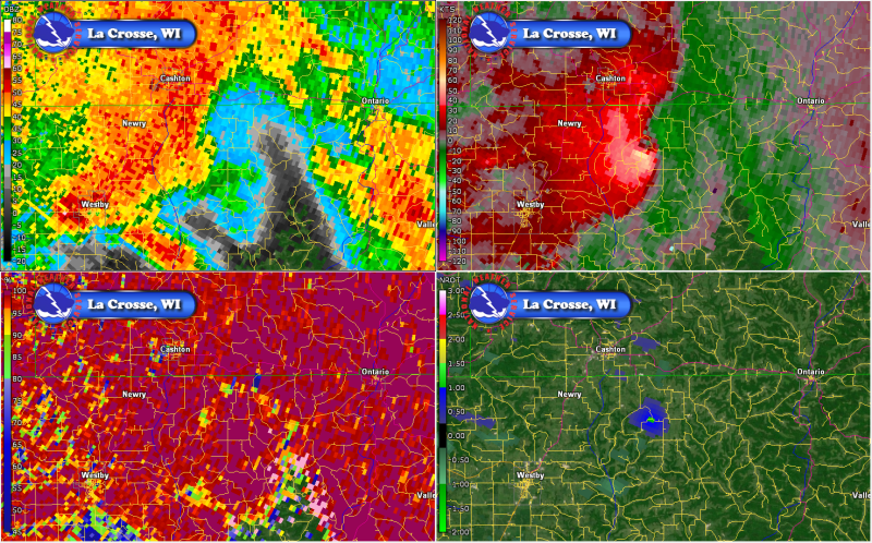
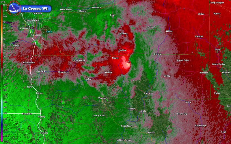
| 4-panel radar image from 11:42 p.m., near the time the tornado began in Vernon Co., WI | Storm-relative velocity at 11:42 p.m., near the time the tornado began in Vernon Co., WI |
Rain Reports
Public Information Statement
National Weather Service La Crosse WI
743 AM CDT Fri Jul 19 2019

...24 Hour Rainfall Totals...

Location                     Amount    Time/Date       Lat/Lon

...IOWA...

...Allamakee County...
Monona 9.8 N                 0.93 in   0700 AM 07/19   43.19N/91.35W

...Clayton County...
McGregor                     1.06 in   0659 AM 07/19   43.02N/91.19W
Monona                       0.60 in   0659 AM 07/19   43.04N/91.39W
Guttenberg Dam 10            0.45 in   0600 AM 07/19   42.79N/91.10W
Volga 1NE                    0.28 in   0610 AM 07/19   42.81N/91.52W

...Fayette County...
Waucoma 3.2 S                0.13 in   0700 AM 07/19   43.01N/92.03W
Fayette                      0.05 in   0700 AM 07/19   42.85N/91.82W

...Floyd County...
Charles City                 0.02 in   0700 AM 07/19   43.06N/92.67W

...Howard County...
Saratoga                     0.35 in   0716 AM 07/19   43.35N/92.42W
Riceville                    0.23 in   0717 AM 07/19   43.40N/92.50W

...Mitchell County...
Osage 4.7 E                  0.16 in   0700 AM 07/19   43.28N/92.72W

...Winneshiek County...
Upper Iowa River             0.18 in   0615 AM 07/19   43.41N/91.90W
Decorah Municipal Airport    0.05 in   0700 AM 07/19   43.27N/91.72W

...MINNESOTA...

...Dodge County...
Mantorville 1.9 ESE          0.50 in   0600 AM 07/19   44.05N/92.72W
Dodge Center Airport         0.06 in   0716 AM 07/19   44.02N/92.82W
Hayfield                     0.03 in   0717 AM 07/19   43.89N/92.85W

...Fillmore County...
1 S Peterson                 1.58 in   0700 AM 07/19
Preston Airport              0.13 in   0715 AM 07/19   43.68N/92.17W

...Houston County...
Money Creek                  5.00 in   0700 AM 07/19
Brownsville                  3.75 in   0720 AM 07/19   43.70N/91.28W
Houston                      2.38 in   0720 AM 07/19   43.79N/91.59W

...Mower County...
Austin 2.4 W                 0.01 in   0700 AM 07/19   43.67N/93.02W

...Olmsted County...
Dover                        2.50 in   0648 AM 07/19   43.97N/92.13W
1 SW Rochester               2.20 in   0600 AM 07/19   44.00N/92.49W
4 ESE Douglas                1.56 in   0700 AM 07/19   44.08N/92.51W
Saint Charles 7.6 NNW        1.53 in   0700 AM 07/19   44.08N/92.10W
Rochester                    1.44 in   0716 AM 07/19   44.04N/92.44W
1 W Chester                  1.41 in   0612 AM 07/19   44.00N/92.38W
Rochester-Beltline Bear Cree 1.40 in   0600 AM 07/19   44.01N/92.45W
3 SE Douglas                 1.10 in   0600 AM 07/19   44.08N/92.53W
Mayo Helipad                 0.96 in   0655 AM 07/19   44.02N/92.48W
Rochester Intl Airport       0.72 in   0654 AM 07/19   43.90N/92.50W
Elgin 2SSW                   0.71 in   0700 AM 07/19   44.10N/92.27W
Cascade Creek                0.71 in   0600 AM 07/19   44.02N/92.53W
Elgin 5SE                    0.69 in   0630 AM 07/19   44.08N/92.19W
Byron                        0.52 in   0722 AM 07/19   44.03N/92.66W

...Wabasha County...
Lake City                    0.66 in   0722 AM 07/19   44.32N/92.44W
Wabasha                      0.66 in   0700 AM 07/19   44.38N/92.05W
Plainview                    0.31 in   0700 AM 07/19   44.17N/92.17W

...Winona County...
1 S Ridgeway                 4.75 in   0638 AM 07/19   43.90N/91.56W
3 S Winona                   4.54 in   0707 AM 07/19   44.00N/91.66W
4 SW Winona                  4.24 in   0715 AM 07/19   43.98N/91.71W
Mississippi River Control Po 4.00 in   0600 AM 07/19   43.91N/91.36W
Dakota                       4.00 in   0600 AM 07/19
La Crescent Dam 7            2.60 in   0600 AM 07/19   43.87N/91.31W
Minnesota City               1.63 in   0600 AM 07/19   44.16N/91.81W
Middle Branch Whitewater Riv 1.50 in   0630 AM 07/19   44.06N/92.05W
Winona Dam 5A                1.38 in   0600 AM 07/19   44.09N/91.67W
North Fork Whitewater River  0.84 in   0600 AM 07/19   44.09N/92.03W

...WISCONSIN...

...Adams County...
Oxford 4.0 W                 0.05 in   0642 AM 07/19   43.79N/89.64W

...Buffalo County...
Mondovi 12.1 SSE             0.69 in   0700 AM 07/19   44.40N/91.60W
Alma Dam 4                   0.60 in   0600 AM 07/19   44.33N/91.92W
Mondovi 0.5 NNE              0.10 in   0700 AM 07/19   44.58N/91.66W

...Crawford County...
Lynxville Dam 9              1.50 in   0600 AM 07/19   43.21N/91.10W
De Soto                      0.12 in   0651 AM 07/19   43.42N/91.19W

...Grant County...
Platteville Municipal Airpor 0.92 in   0655 AM 07/19   42.68N/90.43W
Boscobel Airport             0.89 in   0653 AM 07/19   43.15N/90.68W
Muscoda                      0.79 in   0701 AM 07/19   43.19N/90.46W
Fennimore                    0.48 in   0700 AM 07/19   42.98N/90.66W

...Jackson County...
Black River Falls Area Airpo 0.14 in   0655 AM 07/19   44.25N/90.85W
Black River Falls 1.7 NNE    0.07 in   0700 AM 07/19   44.32N/90.83W

...Juneau County...
Elroy                        1.64 in   0600 AM 07/19   43.74N/90.27W
Volk Field                   0.59 in   0656 AM 07/19   43.92N/90.27W
Mauston                      0.49 in   0722 AM 07/19   43.80N/90.07W
New Lisbon 5.2 ENE           0.41 in   0700 AM 07/19   43.91N/90.07W
Mauston Airport              0.15 in   0715 AM 07/19   43.83N/90.13W

...La Crosse County...
1 N West Salem               4.75 in   0643 AM 07/19   43.91N/91.08W
St. Joseph 3W                4.22 in   0643 AM 07/19   43.78N/91.10W
La Crosse                    4.04 in   0717 AM 07/19   43.77N/91.22W
1 S La Crosse                4.03 in   0716 AM 07/19   43.81N/91.23W
Bangor                       4.00 in   0600 AM 07/19   43.89N/90.99W
Town of Shelby               4.00 in   0700 AM 07/19
Onalaska 0.6 SW              3.94 in   0700 AM 07/19   43.88N/91.23W
2 E La Crosse                3.58 in   0657 AM 07/19   43.82N/91.19W
Holmen 2S                    3.46 in   0430 AM 07/19
La Crosse Regional Airport   3.36 in   0653 AM 07/19   43.88N/91.25W
3 S La Crosse                3.20 in   0635 AM 07/19   43.78N/91.23W

...Monroe County...
Wilton                       4.75 in   0722 AM 07/19   43.82N/90.53W
Cataract                     1.90 in   1155 PM 07/18   44.08N/90.85W
Sparta/Fort McCoy Airport    1.62 in   0655 AM 07/19   43.97N/90.73W
Warrens 4WSW                 0.90 in   0700 AM 07/19   44.10N/90.59W

...Richland County...
Cazenovia 4.3 WNW            2.71 in   0700 AM 07/19   43.54N/90.28W

...Trempealeau County...
1 NW Trempealeau             3.14 in   0630 AM 07/19   44.03N/91.46W
Ettrick 4WNW                 2.42 in   0715 AM 07/19   44.19N/91.34W
Trempealeau Dam 6            2.10 in   0600 AM 07/19   44.00N/91.44W
Trempealeau 7.6 NNW          2.05 in   0700 AM 07/19   44.11N/91.48W
Galesville 1.0 NE            1.55 in   0600 AM 07/19   44.10N/91.34W
Trempealeau                  1.07 in   0722 AM 07/19   44.07N/91.51W

...Vernon County...
Westby 3ENE                  5.74 in   0700 AM 07/19   43.67N/90.81W
Stoddard 5NNE                4.15 in   0600 AM 07/19   43.72N/91.16W
6 SE Westby                  4.00 in   0600 AM 07/19   43.59N/90.78W
Viroqua 0.8 ESE              2.03 in   0700 AM 07/19   43.55N/90.87W
Genoa Dam 8                  1.05 in   0600 AM 07/19   43.57N/91.23W

Observations are collected from a variety of sources with varying
equipment and exposures. We thank all volunteer weather observers
for their dedication. Not all data listed are considered official.

$$
Shea/MA
 |
Media use of NWS Web News Stories is encouraged! Please acknowledge the NWS as the source of any news information accessed from this site. |
|


 Follow us on YouTube