Overview
|
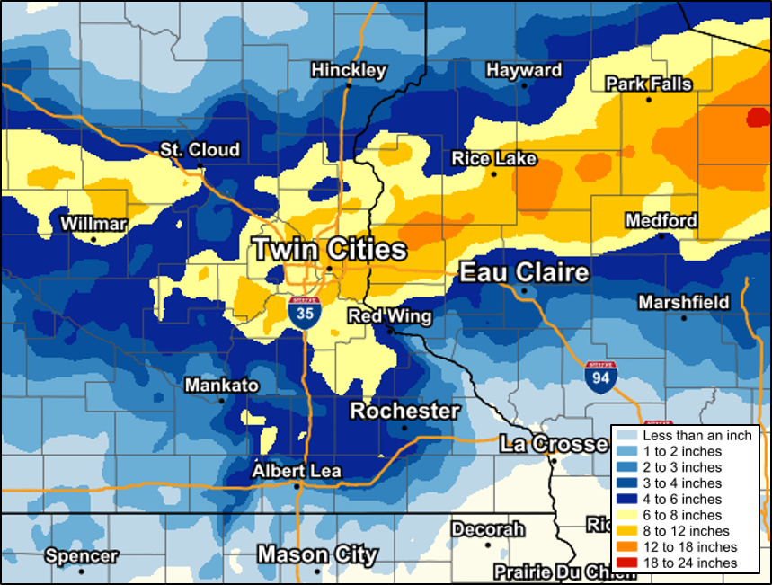
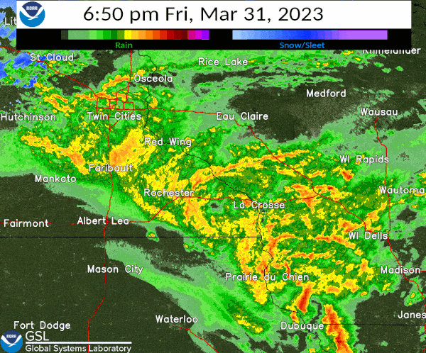
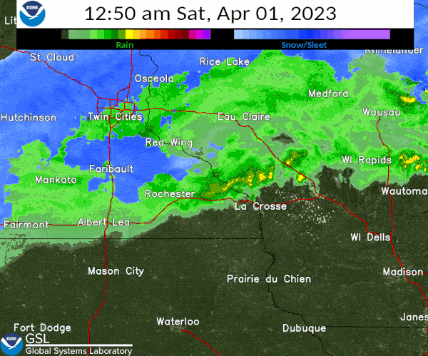
A potent early spring storm brought a variety of impactful weather to the region on Friday, March 31, 2023. Strong to severe storms, snowfall, strong-gusty winds, and heavy rain with localized flooding were all realized. A condensed, 24 hour version of nearly all the weather that can be expected in the spring months. Strong-Severe Storms: Storms developed across Iowa by early-mid afternoon, advancing northeast. The storms became strong to severe, producing damaging winds, large hail and several tornadoes. However, as the storms started to move into northeast Iowa and southwest Wisconsin, the atmosphere was not as favorable for widespread severe storms. There was still some wind damage and large hail, but only one tornado was recorded in the NWS La Crosse service area. NWS Quad Cities had numerous tornadoes from this event. Snow: Farther north, cold air resulted in bands of snow on northern and northwest portions of the storm. The axis of heavier snows ran from the Twin Cities in Minnesota into northeast Wisconsin. Amounts upwards of 1 foot fell - locally, the higher amounts were confined north of highway 29 in north-central Wisconsin. Rain: Rain was plentiful and set some daily records at a few locations. Ponding of water on roads and culverts overflowing were reported. Many rivers also had rises, with the runoff pushing some spots into flood. Wind: Even though some storms produced strong winds, strong and gusty winds were felt across the region as the entire storm system exited. Northwest winds of 35 to 45 mph were common Friday night, slowly diminishing later Saturday morning.
|
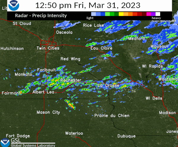 Radar from 1 to 7 pm, March 31st, 2023 |
Wind:
Public Information Statement
National Weather Service La Crosse WI
320 PM CDT Sat Apr 1 2023

...HIGHEST WIND REPORTS LAST 24 HOURS...

Location                     Speed     Time/Date       Lat/Lon

...Iowa...

...Chickasaw County...
New Hampton                  39 MPH    0836 PM 03/31   43.05N/92.30W
Lawler                       28 MPH    0545 PM 03/31   43.18N/92.18W

...Clayton County...
Monona                       31 MPH    0619 PM 03/31   43.04N/91.39W

...Fayette County...
Oelwein Municipal Airport    47 MPH    0815 PM 03/31   42.68N/91.97W

...Floyd County...
Charles City Airport         45 MPH    0915 PM 03/31   43.07N/92.62W
Greene                       44 MPH    0745 PM 03/31   42.93N/92.81W
2 NE Dougherty               31 MPH    0755 PM 03/31   42.95N/93.01W
Nora Springs                 30 MPH    0945 PM 03/31   43.20N/93.02W
Rudd                         26 MPH    0830 PM 03/31   43.18N/92.83W
Charles City                 25 MPH    0736 PM 03/31   43.05N/92.67W

...Howard County...
Saratoga                     40 MPH    0915 PM 03/31   43.35N/92.42W
Riceville                    35 MPH    1045 PM 03/31   43.36N/92.48W

...Mitchell County...
Osage                        32 MPH    1145 PM 03/31   43.26N/92.89W

...Winneshiek County...
Decorah Municipal Airport    43 MPH    0855 PM 03/31   43.27N/91.72W
1 ENE Jackson Junction       32 MPH    0545 PM 03/31   43.11N/92.04W
Calmar                       30 MPH    0755 AM 04/01   43.25N/91.82W
Decorah                      25 MPH    0935 PM 03/31   43.30N/91.79W

...Minnesota...

...Dodge County...
U.s.14 - Byron - Mp 200      40 MPH    0750 AM 04/01   44.02N/92.71W
Dodge Center Airport         36 MPH    0715 PM 03/31   44.02N/92.82W
Hayfield                     26 MPH    0647 PM 03/31   43.89N/92.85W

...Fillmore County...
T.h.52 - Canton - Mp 2       42 MPH    0805 AM 04/01   43.52N/91.89W
U.s.63 - Le Roy - Mp 0.5     41 MPH    1010 PM 03/31   43.51N/92.37W
Preston Airport              39 MPH    0655 AM 04/01   43.68N/92.17W

...Houston County...
Hokah                        31 MPH    1100 AM 04/01   43.80N/91.43W
T.h.44 - Hokah - Mp 60       28 MPH    0715 AM 04/01   43.72N/91.44W

...Mower County...
I-90 - Dexter - Mp 195       44 MPH    0615 AM 04/01   43.73N/92.68W
U.s.218 - Lyle - Mp 4        41 MPH    0845 AM 04/01   43.56N/92.95W
Austin Municipal Airport     37 MPH    0617 AM 04/01   43.67N/92.92W
Lyle                         28 MPH    0755 AM 04/01   43.51N/92.94W
Austin                       28 MPH    0545 AM 04/01   43.56N/93.02W
Austin                       28 MPH    0928 AM 04/01   43.65N/93.00W

...Olmsted County...
Rochester International Airp 49 MPH    0707 PM 03/31   43.90N/92.50W
Mayo Helipad                 43 MPH    0735 PM 03/31   44.02N/92.48W
U.s.63 - Stewartville - Mp 3 40 MPH    0715 PM 03/31   43.90N/92.48W
I-90 - Eyota - Mp 226        38 MPH    0500 AM 04/01   43.96N/92.21W
Rochester                    36 MPH    0805 PM 03/31   44.09N/92.51W
Rochester                    34 MPH    0830 PM 03/31   44.18N/92.41W
Rochester                    30 MPH    0755 PM 03/31   44.09N/92.49W
Rochester                    27 MPH    0746 PM 03/31   44.04N/92.44W

...Wabasha County...
U.s.63 - Lake City - Mp 62.9 38 MPH    0455 PM 03/31   44.38N/92.37W
Lake City                    34 MPH    0943 PM 03/31   44.32N/92.44W
Lake City                    27 MPH    0800 AM 04/01   44.44N/92.28W

...Winona County...
I-90 - La Crescent - Mp 276. 41 MPH    0945 AM 04/01   43.86N/91.30W
I-90 - Ridgeway - Mp 261     36 MPH    0555 AM 04/01   43.91N/91.54W
Winona Municipal Airport     28 MPH    0655 AM 04/01   44.07N/91.70W
U.s.61 - Winona              25 MPH    0920 AM 04/01   43.98N/91.43W

...Wisconsin...

...Crawford County...
Steuben                      42 MPH    0900 PM 03/31   43.21N/91.00W
Prairie Du Chien  Airport    38 MPH    0655 PM 03/31   43.02N/91.12W

...Grant County...
Lancaster                    46 MPH    0741 PM 03/31   42.83N/90.69W
Platteville Municipal Airpor 44 MPH    1015 PM 03/31   42.68N/90.43W
Boscobel Airport             40 MPH    0936 PM 03/31   43.15N/90.68W
Lancaster                    37 MPH    0900 PM 03/31   42.83N/90.79W
Boscobel                     28 MPH    0803 PM 03/31   43.15N/90.68W

...Jackson County...
Black River Falls Area Airpo 28 MPH    1035 AM 04/01   44.25N/90.85W
1 E Black River Falls        27 MPH    0915 AM 04/01   44.30N/90.73W

...Juneau County...
Volk Field                   32 MPH    1021 AM 04/01   43.92N/90.27W
Necedah                      32 MPH    1248 PM 04/01   44.03N/90.08W
Mauston Airport              26 MPH    1015 AM 04/01   43.83N/90.13W

...La Crosse County...
La Crosse Regional Airport   38 MPH    1057 AM 04/01   43.88N/91.25W
La Crosse                    33 MPH    0958 AM 04/01   43.81N/91.25W
La Crosse                    32 MPH    0708 AM 04/01   43.82N/91.19W
La Crosse                    30 MPH    0945 AM 04/01   43.77N/91.22W
Onalaska                     30 MPH    0826 AM 04/01   43.89N/91.18W
Burns                        28 MPH    0536 PM 03/31   43.91N/90.97W
Holmen                       25 MPH    0735 AM 04/01   43.96N/91.23W

...Monroe County...
Millston                     26 MPH    0605 PM 03/31   44.15N/90.69W
Sparta/Fort McCoy Airport    25 MPH    0955 AM 04/01   43.97N/90.73W

...Taylor County...
Medford Airport              37 MPH    0535 AM 04/01   45.10N/90.30W
Westboro                     36 MPH    0735 AM 04/01   45.37N/90.31W
3 NE Lublin                  35 MPH    0814 AM 04/01   45.11N/90.69W
Medford                      33 MPH    0645 AM 04/01   45.30N/90.30W
Gilman                       25 MPH    0625 PM 03/31   45.17N/90.82W

...Vernon County...
Viroqua Municipal Airport    35 MPH    0915 AM 04/01   43.58N/90.90W

Observations are collected from a variety of sources with varying
equipment and exposures. We thank all volunteer weather observers
for their dedication. Not all data listed are considered off
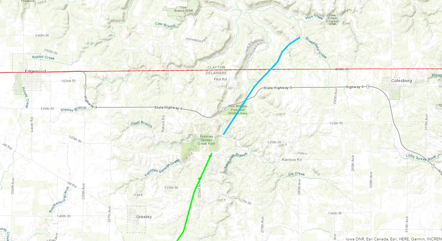
Tornado:
|
Tornado - Ed/Co Countyline
|
||||||||||||||||
The Enhanced Fujita (EF) Scale classifies tornadoes into the following categories:
| EF0 Weak 65-85 mph |
EF1 Moderate 86-110 mph |
EF2 Significant 111-135 mph |
EF3 Severe 136-165 mph |
EF4 Extreme 166-200 mph |
EF5 Catastrophic 200+ mph |
 |
|||||
Snowfall
...SNOW REPORTS FROM MARCH 31 TO APRIL 1...

LOCATION                     AMOUNT    TIME/DATE       LAT/LON

...MINNESOTA...

...DODGE COUNTY...
1 ENE KASSON                 5.6 IN    0657 AM 04/01   44.04N/92.73W
MANTORVILLE                  5.0 IN    1101 AM 04/01   44.07N/92.76W
HAYFIELD 0.3 SSE             4.5 IN    0230 AM 04/01   43.89N/92.85W

...FILLMORE COUNTY...
CHATFIELD                    2.0 IN    0659 AM 04/01   43.85N/92.19W

...HOUSTON COUNTY...
CALEDONIA                    0.3 IN    1030 AM 04/01   43.63N/91.50W

...MOWER COUNTY...
RACINE                       5.0 IN    0801 AM 04/01   43.78N/92.48W
2 NE LANSING                 5.0 IN    1100 AM 04/01   43.76N/92.95W
4 WSW AUSTIN                 3.0 IN    0705 AM 04/01   43.64N/93.05W
2 SW AUSTIN                  3.0 IN    1200 PM 04/01   43.65N/93.00W
3 WNW LE ROY                 1.0 IN    0636 AM 04/01   43.53N/92.56W

...OLMSTED COUNTY...
STEWARTVILLE                 5.5 IN    1232 PM 04/01   43.86N/92.49W
3 WNW ROCHESTER              4.8 IN    0659 AM 04/01   44.03N/92.53W
2 NE ROCHESTER AP            4.6 IN    0700 AM 04/01   43.93N/92.47W
3 ESE DOUGLAS                4.5 IN    0700 AM 04/01   44.08N/92.51W
2 NNW ROCHESTER              4.5 IN    0710 AM 04/01   44.04N/92.50W
2 WSW ROCHESTER              4.5 IN    1004 AM 04/01   44.00N/92.52W
1 N BYRON                    4.5 IN    1023 AM 04/01   44.04N/92.65W
3 SW CUMMINGSVILLE           4.1 IN    0754 AM 04/01   43.85N/92.30W
2 SSE ROCHESTER              4.0 IN    0853 AM 04/01   43.99N/92.47W
4 SE DOUGLAS                 4.0 IN    1114 AM 04/01   44.07N/92.52W
2 NNE ROCHESTER              3.7 IN    0943 AM 04/01   44.04N/92.46W
2 NNW ROCHESTER              3.5 IN    0900 AM 04/01   44.04N/92.50W
1 SSW ORONOCO                3.4 IN    0936 AM 04/01   44.15N/92.54W
2 S PREDMORE                 3.3 IN    0612 AM 04/01   43.90N/92.34W
1 N ROCHESTER                3.0 IN    1205 PM 04/01   44.03N/92.47W

...WABASHA COUNTY...
ZUMBRO FALLS                 4.5 IN    0953 AM 04/01   44.29N/92.42W
ELGIN                        3.0 IN    0744 AM 04/01   44.13N/92.25W
4 NNE MILLVILLE              2.0 IN    1017 AM 04/01   44.30N/92.28W

...WINONA COUNTY...
LEWISTON                     4.3 IN    0812 AM 04/01   43.99N/91.87W

...WISCONSIN...

...BUFFALO COUNTY...
MONDOVI                      2.0 IN    0500 PM 04/01   44.56N/91.67W
URNE                         1.0 IN    0748 AM 04/01   44.50N/91.89W
ALMA                         0.5 IN    0535 AM 04/01   44.32N/91.92W

...CLARK COUNTY...
2 S LONGWOOD                 6.0 IN    0952 AM 04/01   44.86N/90.60W
5 W RIPLINGER                4.0 IN    0740 AM 04/01   44.82N/90.50W
COLBY 5.9 WSW                4.0 IN    0700 PM 04/01   44.87N/90.42W
6 N CHILI                    2.5 IN    0754 AM 04/01   44.71N/90.34W
NEILLSVILLE                  1.0 IN    0546 AM 04/01   44.56N/90.59W

...CRAWFORD COUNTY...
EASTMAN                      0.2 IN    0658 PM 04/01   43.17N/91.02W

...JACKSON COUNTY...
4 NE NORTH BEND              0.4 IN    0750 AM 04/01   44.13N/91.07W

...LA CROSSE COUNTY...
SAINT JOSEPH                 1.0 IN    0743 AM 04/01   43.79N/91.04W
2 E LA CROSSE                0.4 IN    0700 AM 04/01   43.82N/91.19W

...TAYLOR COUNTY...
WESTBORO                     15.0 IN   0637 AM 04/01   45.36N/90.30W
4 E HANNIBAL                 10.0 IN   0702 AM 04/01   45.26N/90.70W
RIB LAKE                     10.0 IN   0909 AM 04/01   45.32N/90.20W
GILMAN                       10.0 IN   0926 AM 04/01   45.17N/90.81W
MEDFORD                      5.0 IN    0516 AM 04/01   45.14N/90.35W
2 N DORCHESTER               5.0 IN    0741 AM 04/01   45.04N/90.34W

...TREMPEALEAU COUNTY...
OSSEO                        1.5 IN    1118 AM 04/01   44.58N/91.22W

OBSERVATIONS ARE COLLECTED FROM A VARIETY OF SOURCES WITH VARYING
EQUIPMENT AND EXPOSURES. WE THANK ALL VOLUNTEER WEATHER OBSERVERS
FOR THEIR DEDICATION. NOT ALL DATA LISTED ARE CONSIDERED OFFICIAL.
Photos:
 |
|||
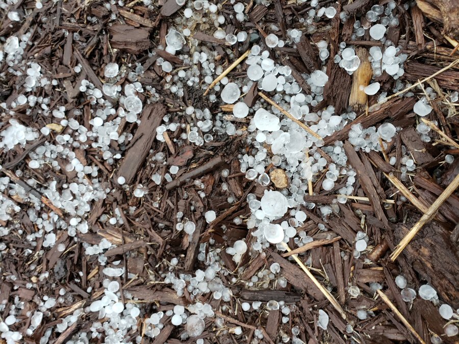
| Hail at NWS La Crosse (NWS La Crosse Staff) |
Caption (source) |
Caption (source) |
Caption (source) |
Radar:
|
 |
 |
|
| Radar from 1 to 7 pm | Radar from 7 pm to 1 am | Radar from 1 to 7 am |
Storm Reports
PRELIMINARY LOCAL STORM REPORT...SUMMARY
NATIONAL WEATHER SERVICE LA CROSSE WI
722 PM CDT FRI MAR 31 2023

..TIME...   ...EVENT...      ...CITY LOCATION...     ...LAT.LON...
..DATE...   ....MAG....      ..COUNTY LOCATION..ST.. ...SOURCE....
            ..REMARKS..

0405 PM     HAIL             2 S NEW HAVEN           43.25N 92.64W
03/31/2023  M1.00 INCH       MITCHELL           IA   EMERGENCY MNGR

            NICKEL TO QUARTER SIZE HAIL.

0418 PM     HAIL             3 NW RICEVILLE          43.39N 92.61W
03/31/2023  M0.50 INCH       MITCHELL           IA   PUBLIC

            REPORT FROM MPING: HALF-INCH (0.50 IN.).

0418 PM     HAIL             3 NW RICEVILLE          43.39N 92.61W
03/31/2023  U0.50 INCH       MITCHELL           IA   PUBLIC

            REPORT FROM MPING: HALF-INCH (0.50 IN.).

0430 PM     HAIL             LIME SPRINGS            43.45N 92.28W
03/31/2023  M0.25 INCH       HOWARD             IA   PUBLIC


0436 PM     HAIL             1 N STACYVILLE          43.46N 92.78W
03/31/2023  M1.25 INCH       MITCHELL           IA   PUBLIC

            REPORT FROM MPING: HALF DOLLAR (1.25 IN.).

0436 PM     HAIL             1 ESE MARBLE ROCK       42.96N 92.85W
03/31/2023  M0.50 INCH       FLOYD              IA   PUBLIC

            REPORT FROM MPING: HALF-INCH (0.50 IN.).

0436 PM     HAIL             1 N STACYVILLE          43.46N 92.78W
03/31/2023  U1.25 INCH       MITCHELL           IA   PUBLIC

            REPORT FROM MPING: HALF DOLLAR (1.25 IN.).

0446 PM     HAIL             5 SE DECORAH            43.26N 91.72W
03/31/2023  E0.25 INCH       WINNESHIEK         IA   COCORAHS

            3 MINUTES OF PEA SIZE HAIL.

0453 PM     HAIL             PRESTON                 43.67N 92.08W
03/31/2023  M0.25 INCH       FILLMORE           MN   LAW ENFORCEMENT


0454 PM     HAIL             3 S GREENLEAFTON        43.54N 92.21W
03/31/2023  M0.88 INCH       FILLMORE           MN   LAW ENFORCEMENT


0454 PM     HAIL             5 SE DECORAH            43.26N 91.72W
03/31/2023  E0.25 INCH       WINNESHIEK         IA   PUBLIC

            2 MINUTES OF PEA SIZE HAIL.

0500 PM     HAIL             2 S FLOYD               43.10N 92.74W
03/31/2023  E0.25 INCH       FLOYD              IA   PUBLIC


0503 PM     HAIL             OELWEIN                 42.68N 91.91W
03/31/2023  E0.25 INCH       FAYETTE            IA   PUBLIC


0504 PM     HAIL             2 NNE ROCHESTER         44.04N 92.46W
03/31/2023  M0.70 INCH       OLMSTED            MN   TRAINED SPOTTER


0510 PM     HAIL             DODGE CENTER            44.02N 92.84W
03/31/2023  M0.25 INCH       DODGE              MN   PUBLIC


0516 PM     HAIL             CLAYTON CENTER          42.88N 91.33W
03/31/2023  M0.25 INCH       CLAYTON            IA   EMERGENCY MNGR


0522 PM     HAIL             LYNDON STATION          43.71N 89.90W
03/31/2023  E0.50 INCH       JUNEAU             WI   PUBLIC


0524 PM     HAIL             3 ESE DOUGLAS           44.09N 92.51W
03/31/2023  M0.25 INCH       OLMSTED            MN   BROADCAST MEDIA


0524 PM     HAIL             3 ESE DOUGLAS           44.09N 92.52W
03/31/2023  M0.25 INCH       OLMSTED            MN   PUBLIC


0540 PM     HAIL             1 NE BARRE MILLS        43.85N 91.11W
03/31/2023  M0.50 INCH       LA CROSSE          WI   PUBLIC

            .

0540 PM     HAIL             1 NE BARRE MILLS        43.85N 91.11W
03/31/2023  M0.50 INCH       LA CROSSE          WI   PUBLIC


0540 PM     HAIL             1 E WHITE CREEK         43.83N 89.84W
03/31/2023  M0.25 INCH       ADAMS              WI   TRAINED SPOTTER


0541 PM     HAIL             3 SE LA CROSSE          43.79N 91.20W
03/31/2023  M0.50 INCH       LA CROSSE          WI   PUBLIC

            REPORT FROM MPING: HALF-INCH (0.50 IN.).

0541 PM     HAIL             3 SE LA CROSSE          43.79N 91.20W
03/31/2023  U0.50 INCH       LA CROSSE          WI   PUBLIC

            REPORT FROM MPING: HALF-INCH (0.50 IN.).

0545 PM     HAIL             3 SE LA CROSSE          43.79N 91.20W
03/31/2023  M0.50 INCH       LA CROSSE          WI   PUBLIC

            REPORT FROM MPING: HALF-INCH (0.50 IN.).

0545 PM     HAIL             3 SE LA CROSSE          43.79N 91.20W
03/31/2023  U0.50 INCH       LA CROSSE          WI   PUBLIC

            REPORT FROM MPING: HALF-INCH (0.50 IN.).

0546 PM     HAIL             2 E LA CROSSE           43.82N 91.19W
03/31/2023  E0.88 INCH       LA CROSSE          WI   OFFICIAL NWS OBS


0547 PM     HAIL             3 SSW BARRE MILLS       43.80N 91.15W
03/31/2023  M1.00 INCH       LA CROSSE          WI   PUBLIC


0549 PM     HAIL             ARKDALE                 44.03N 89.88W
03/31/2023  E1.25 INCH       ADAMS              WI   PUBLIC


0550 PM     HAIL             3 E ONALASKA            43.89N 91.17W
03/31/2023  M0.50 INCH       LA CROSSE          WI   PUBLIC

            REPORT FROM MPING: HALF-INCH (0.50 IN.).

0550 PM     HAIL             3 E ONALASKA            43.89N 91.17W
03/31/2023  U0.50 INCH       LA CROSSE          WI   PUBLIC

            REPORT FROM MPING: HALF-INCH (0.50 IN.).

0601 PM     TSTM WND DMG     GUTTENBERG              42.79N 91.10W
03/31/2023                   CLAYTON            IA   AMATEUR RADIO

            TREES DAMAGED.

0604 PM     HAIL             LANCASTER               42.85N 90.71W
03/31/2023  M0.25 INCH       GRANT              WI   FIRE DEPT/RESCUE


0608 PM     HAIL             4 ESE NEW ROME          44.22N 89.81W
03/31/2023  E0.50 INCH       ADAMS              WI   PUBLIC


0630 PM     TSTM WND DMG     DICKEYVILLE             42.63N 90.59W
03/31/2023                   GRANT              WI   PUBLIC

            SIGN DAMAGE NOTED.

0631 PM     TSTM WND GST     POTOSI                  42.69N 90.71W
03/31/2023  E40 MPH          GRANT              WI   FIRE DEPT/RESCUE


0650 PM     FLOOD            2 NW TOMAH              44.01N 90.52W
03/31/2023                   MONROE             WI   PUBLIC

            REPORT FROM MPING: RIVER/CREEK OVERFLOWING;
            CROPLAND/YARD/BASEMENT FLOODING.

0652 PM     HAIL             TOMAH                   43.98N 90.50W
03/31/2023  E0.25 INCH       MONROE             WI   PUBLIC


0656 PM     TSTM WND GST     CUBA CITY               42.60N 90.43W
03/31/2023  E60 MPH          GRANT              WI   FIRE DEPT/RESCUE


&&
Rain Reports
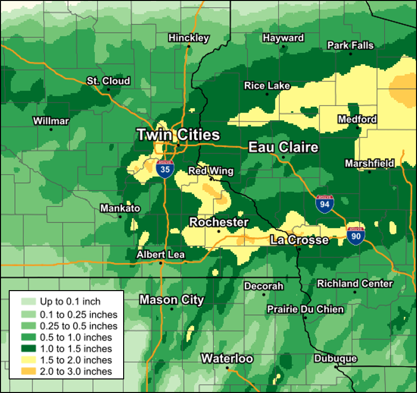
Public Information Statement
National Weather Service La Crosse WI
806 AM CDT Fri Mar 31 2023

...24 Hour Rainfall Reports...

Location                     Amount    Time/Date       Lat/Lon

...Iowa...

...Allamakee County...
Harpers Ferry 6.4 SSW        0.56 in   0700 AM 03/31   43.11N/91.20W
3 SE Waterville              0.29 in   0707 AM 03/31   43.17N/91.24W
Lansing 4.1 NW               0.26 in   0700 AM 03/31   43.40N/91.29W

...Chickasaw County...
New Hampton                  0.60 in   0728 AM 03/31   43.05N/92.30W
New Hampton 0.4 SW           0.51 in   0700 AM 03/31   43.06N/92.32W
Ionia 2W                     0.38 in   0645 AM 03/31   43.03N/92.50W
New Hampton                  0.29 in   0735 AM 03/31   43.06N/92.32W

...Clayton County...
Mcgregor                     0.77 in   0734 AM 03/31   43.02N/91.19W
Big Spring Fish Hatchery     0.64 in   0700 AM 03/31   42.91N/91.47W
Elkader 6.8 WSW              0.57 in   0630 AM 03/31   42.81N/91.52W
McGregor 6.4 WNW             0.55 in   0629 AM 03/31   43.07N/91.29W
Elkader 6SSW                 0.31 in   0700 AM 03/31   42.78N/91.45W
1 WSW Marquette              0.28 in   0700 AM 03/31   43.04N/91.21W
Littleport                   0.19 in   0645 AM 03/31   42.75N/91.37W
Strawberry Point             0.12 in   0700 AM 03/31   42.69N/91.53W

...Fayette County...
Waucoma 3.2 S                0.34 in   0700 AM 03/31   43.01N/92.03W
Eldorado 1E - Turkey River   0.25 in   0645 AM 03/31   43.05N/91.81W

...Floyd County...
Nora Springs 2.4 SSE         0.35 in   0700 AM 03/31   43.11N/92.99W
Charles City                 0.29 in   0728 AM 03/31   43.05N/92.67W
Charles City                 0.29 in   0537 AM 03/31   43.05N/92.67W

...Howard County...
Riceville                    0.35 in   0715 AM 03/31   43.36N/92.48W
Saratoga                     0.31 in   0715 AM 03/31   43.35N/92.42W

...Mitchell County...
Saint Ansgar                 0.45 in   0740 AM 03/31   43.38N/92.92W
St.Ansgar                    0.41 in   0725 AM 03/31   43.38N/92.92W
Osage 4.7 E                  0.35 in   0700 AM 03/31   43.28N/92.72W
St Ansgar                    0.35 in   0630 AM 03/31   43.38N/92.92W
Stacyville                   0.31 in   0728 AM 03/31   43.44N/92.78W

...Winneshiek County...
Decorah 4.9SE                0.55 in   0700 AM 03/31   43.26N/91.70W
Decorah                      0.47 in   0645 AM 03/31   43.30N/91.80W
Spillville                   0.37 in   0630 AM 03/31   43.21N/91.95W
1 ENE Jackson Junction       0.37 in   0535 AM 03/31   43.11N/92.04W

...Minnesota...

...Dodge County...
Hayfield                     0.70 in   0727 AM 03/31   43.89N/92.85W

...Fillmore County...
Mabel                        0.43 in   0615 AM 03/31   43.52N/91.76W
1 NNW Fillmore               0.33 in   0730 AM 03/31   43.76N/92.27W
Wykoff 3.1 NW                0.27 in   0700 AM 03/31   43.74N/92.31W

...Houston County...
Caledonia                    0.45 in   0600 AM 03/31   43.63N/91.50W
La Crescent 1.0 WSW          0.44 in   0700 AM 03/31   43.83N/91.32W
Mound Prairie                0.43 in   0645 AM 03/31   43.78N/91.45W
Hokah                        0.41 in   0720 AM 03/31   43.80N/91.43W
Houston                      0.34 in   0725 AM 03/31   43.77N/91.58W

...Mower County...
Austin                       0.56 in   0726 AM 03/31   43.65N/93.00W
Austin 2.4 W                 0.36 in   0700 AM 03/31   43.67N/93.02W
Austin                       0.31 in   0536 AM 03/31   43.65N/93.00W

...Olmsted County...
Elgin 2SSW                   1.10 in   0700 AM 03/31   44.10N/92.27W
Rochester                    1.01 in   0730 AM 03/31   44.05N/92.45W
Rochester                    1.01 in   0540 AM 03/31   44.05N/92.45W
Rochester                    0.97 in   0725 AM 03/31   44.09N/92.49W
2 NNW Rochester              0.97 in   0700 AM 03/31   44.05N/92.49W
Oronoco 3.3 ESE              0.92 in   0700 AM 03/31   44.14N/92.48W
Rochester 4.2 N              0.90 in   0600 AM 03/31   44.08N/92.49W
Byron                        0.89 in   0715 AM 03/31   44.04N/92.64W
Byron 0.3 NNE                0.86 in   0601 AM 03/31   44.04N/92.64W
Rochester                    0.81 in   0730 AM 03/31   44.09N/92.51W
Rochester 1.3 ENE            0.81 in   0700 AM 03/31   44.02N/92.45W
Rochester                    0.81 in   0540 AM 03/31   44.09N/92.51W
Rochester 1.5 WSW            0.80 in   0600 AM 03/31   44.00N/92.50W
Rochester                    0.78 in   0730 AM 03/31   44.05N/92.53W
Rochester                    0.78 in   0540 AM 03/31   44.05N/92.53W
3 W Rochester                0.70 in   0630 AM 03/31   44.02N/92.53W
Rochester                    0.69 in   0730 AM 03/31   44.18N/92.41W
Rochester                    0.68 in   0724 AM 03/31   44.04N/92.44W
Mayo Helipad                 0.62 in   0715 AM 03/31   44.02N/92.48W
1 W Oronoco                  0.54 in   0730 AM 03/31   44.17N/92.55W
3 ENE Rochester              0.50 in   0630 AM 03/31   44.03N/92.43W
Rochester-Beltline Bear Cree 0.50 in   0630 AM 03/31   44.01N/92.45W
5 WSW Rochester              0.49 in   0700 AM 03/31   43.98N/92.56W
Rochester International Airp 0.36 in   0729 AM 03/31   43.90N/92.50W
2 NE Rochester               0.36 in   0600 AM 03/31   44.04N/92.44W
Rochester-Cascade Creek      0.31 in   0630 AM 03/31   44.03N/92.47W
2 W High Forest              0.24 in   0700 AM 03/31   43.85N/92.59W
6 NNW Genoa                  0.14 in   0700 AM 03/31   44.19N/92.65W
Eyota 2NE                    0.12 in   0630 AM 03/31   44.02N/92.20W

...Wabasha County...
Plainview                    0.61 in   0720 AM 03/31   44.17N/92.17W
Lake City                    0.59 in   0715 AM 03/31   44.44N/92.28W
Kellogg 0.1 N                0.54 in   0700 AM 03/31   44.31N/92.00W
Lake City                    0.49 in   0722 AM 03/31   44.32N/92.44W
Wabasha 6.2 WNW              0.45 in   0700 AM 03/31   44.39N/92.16W
1 N Kellogg                  0.26 in   0700 AM 03/31   44.32N/92.00W
3 ESE Mazeppa                0.12 in   0600 AM 03/31   44.26N/92.49W

...Winona County...
Beaver                       1.36 in   0600 AM 03/31   44.15N/92.00W
Beaver                       0.90 in   0645 AM 03/31   44.15N/92.00W
1 WSW Elba                   0.65 in   0645 AM 03/31   44.09N/92.03W
Winona 2.0 ESE               0.52 in   0700 AM 03/31   44.04N/91.63W
4.2 N Rollingstone           0.41 in   0600 AM 03/31   44.16N/91.81W
La Crescent 4.0 NNW          0.38 in   0725 AM 03/31   43.88N/91.34W
Whitewater State Park        0.31 in   0630 AM 03/31   44.05N/92.05W
3 SW Elba                    0.25 in   0630 AM 03/31   44.06N/92.05W

...Wisconsin...

...Adams County...
0.6 W Friendship             0.65 in   0700 AM 03/31   43.98N/89.83W
Oxford 4.0 W                 0.63 in   0700 AM 03/31   43.79N/89.64W

...Buffalo County...
Mondovi 12.1 SSE             0.58 in   0615 AM 03/31   44.40N/91.60W

...Crawford County...
Prairie Du Chien 1.4 N       0.60 in   0700 AM 03/31   43.06N/91.14W
Prairie Du Chien  Airport    0.58 in   0715 AM 03/31   43.02N/91.12W
0.6 NE Prairie Du Chien      0.58 in   0700 AM 03/31   43.05N/91.13W
Eastman 2.4 NNE              0.39 in   0700 AM 03/31   43.20N/91.00W
De Soto                      0.31 in   0726 AM 03/31   43.42N/91.19W
De Soto                      0.31 in   0536 AM 03/31   43.42N/91.19W
1 S De Soto                  0.27 in   0751 AM 03/31   43.41N/91.19W
Steuben                      0.22 in   0645 AM 03/31   43.18N/90.86W
2.8 E Harpers Ferry          0.03 in   0715 AM 03/31   43.21N/91.10W

...Grant County...
Muscoda                      0.65 in   0725 AM 03/31   43.19N/90.46W
Muscoda                      0.65 in   0540 AM 03/31   43.19N/90.46W
Platteville                  0.53 in   0725 AM 03/31   42.74N/90.46W
Boscobel                     0.50 in   0703 AM 03/31   43.15N/90.68W
Platteville                  0.48 in   0540 AM 03/31   42.74N/90.46W
Boscobel Airport             0.47 in   0705 AM 03/31   43.15N/90.68W
1 NE Platteville             0.28 in   0700 AM 03/31   42.75N/90.46W
Fennimore                    0.28 in   0535 AM 03/31   42.98N/90.66W
Cassville 7.8 ENE            0.12 in   0700 AM 03/31   42.75N/90.84W
Lancaster                    0.10 in   0641 AM 03/31   42.83N/90.69W

...Jackson County...
1 E Black River Falls        0.90 in   0715 AM 03/31   44.30N/90.73W
Mather 3NW                   0.70 in   0700 AM 03/31   44.17N/90.35W
Black River Falls Area Airpo 0.50 in   0715 AM 03/31   44.25N/90.85W
Melrose 3.6 W                0.48 in   0700 AM 03/31   44.13N/91.07W

...Juneau County...
New Lisbon                   0.68 in   0715 AM 03/31   43.87N/90.17W
Necedah                      0.57 in   0648 AM 03/31   44.03N/90.08W
Volk Field                   0.53 in   0658 AM 03/31   43.92N/90.27W
Mauston Airport              0.52 in   0715 AM 03/31   43.83N/90.13W
NECEDAH NWR RY DAM NECEDAH 5 0.39 in   0710 AM 03/31   44.06N/90.17W
0.6 W Necedah                0.37 in   0648 AM 03/31   44.02N/90.08W

...La Crosse County...
La Crosse                    0.52 in   0730 AM 03/31   43.77N/91.22W
La Crosse                    0.47 in   0708 AM 03/31   43.82N/91.19W
Coon Valley 4.5 NNW          0.47 in   0700 AM 03/31   43.76N/91.06W
Burns                        0.39 in   0729 AM 03/31   43.91N/90.97W
Onalaska                     0.39 in   0726 AM 03/31   43.89N/91.18W
Onalaska 1.9 E               0.39 in   0700 AM 03/31   43.89N/91.18W
La Crosse Regional Airport   0.38 in   0722 AM 03/31   43.88N/91.25W
Onalaska                     0.38 in   0536 AM 03/31   43.89N/91.18W
Coon Valley 4.5 NNW          0.37 in   0600 AM 03/31   43.76N/91.06W
La Crosse                    0.34 in   0728 AM 03/31   43.81N/91.25W
La Crosse                    0.33 in   0538 AM 03/31   43.81N/91.25W

...Monroe County...
Sparta/Fort McCoy Airport    0.38 in   0655 AM 03/31   43.97N/90.73W

...Taylor County...
Westboro                     0.93 in   0725 AM 03/31   45.37N/90.31W
Medford                      0.75 in   0715 AM 03/31   45.30N/90.30W
Medford 0.8 ENE              0.72 in   0700 AM 03/31   45.14N/90.33W
3 NE Lublin                  0.66 in   0614 AM 03/31   45.11N/90.69W

...Trempealeau County...
Ettrick 4.0 WNW              0.84 in   0704 AM 03/31   44.19N/91.34W
Trempealeau 7.6 NNW          0.60 in   0700 AM 03/31   44.11N/91.48W
Trempealeau                  0.53 in   0729 AM 03/31   44.07N/91.51W

...Vernon County...
La Farge                     0.74 in   0715 AM 03/31   43.60N/90.63W
Viroqua 0.8 ESE              0.64 in   0700 AM 03/31   43.55N/90.87W
Genoa                        0.38 in   0722 AM 03/31   43.56N/91.22W
Viroqua Municipal Airport    0.35 in   0715 AM 03/31   43.58N/90.90W

Observations are collected from a variety of sources with varying
equipment and exposures. We thank all volunteer weather observers
for their dedication. Not all data listed are considered official.

$$
 |
Media use of NWS Web News Stories is encouraged! Please acknowledge the NWS as the source of any news information accessed from this site. |
|


 Follow us on YouTube