| What caused it to occur? | What Happened? | Snow Amounts |
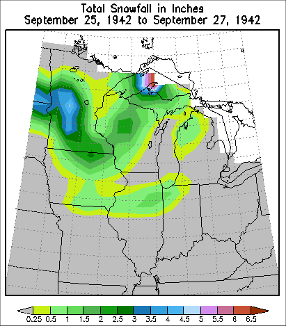
From September 24th through the 26th, 1942, an early season winter storm moved through the Northern Plains, Upper Mississippi River Valley, and Great Lakes, dropping measurable snow as as it went. In many places across Minnesota, Iowa, Wisconsin, and northern Illinois, this was their earliest measurable snow on record. The highest snowfall total was 9 inches at Sauk Centre, MN. Parts of northern Missouri saw their earliest traces of snow.
Prior to the storm's passage through the Northern Plains, Upper Mississippi River Valley, and Great Lakes, an abnormally cool air mass resided across these regions. High temperatures were mainly in the 30s and 40s. This was 20 to 30 degrees below the late September normals.
A surface low pressure system moved southeast through southern Alberta and western North Dakota during the evening of September 24th and the early morning hours of September 25th. This low then moved east southeast across southern North Dakota and northeast South Dakota during the late morning and afternoon of the 25th. By 7:30 PM, the low was located just north of Aberdeen, South Dakota.
During the late evening of the 25th and early morning hours of the 26th, the surface low continued to move east southeast across southern Minnesota and southern Wisconsin. By 7:30 AM on September 26th, the surface low was located near Madison, WI. This low then began moving east northeast across southeast Wisconsin and central lower Michigan during the late morning and afternoon. By 7:30 PM on the 26th, the low was located just north of Georgian Bay.
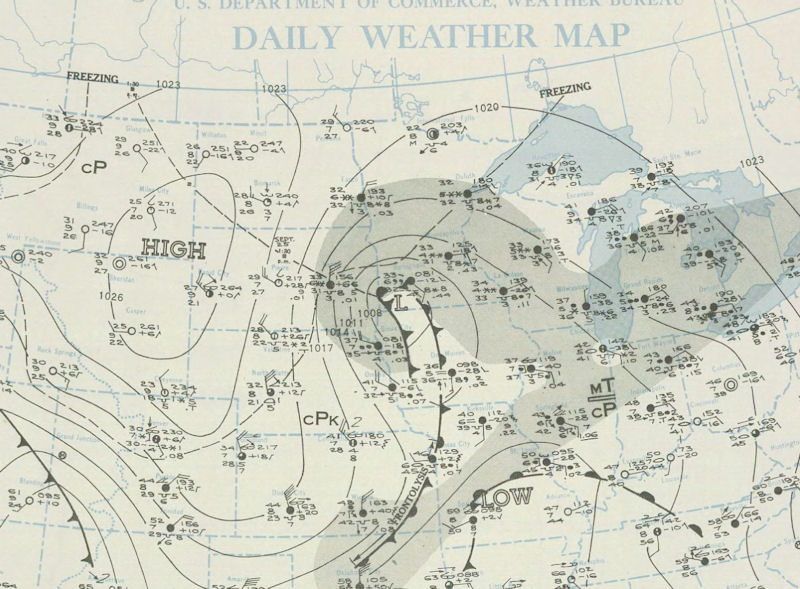
September 25, 1942 at 730 PM
North Dakota...
The highest snowfall recorded in September occurred on the 25th and 26th - heaviest in the central part of the state. Many tree branches and shrubs were broken by the weight of the snow. Threshing was seriously delayed by the wet weather. Following the snow, a severe freeze on the 26th through 28th froze the ground to a depth of 3 inches in a few localities. Gardens were destroyed and considerable corn and flax were damaged. Parshall's (Mountrail County) low temperature on the morning of the 26th fell to 4 degrees.
Minnesota...
On the 25th and 26th, a destructive sleet, snow, and windstorm in west-central counties caused a loss estimated at $25,000 to overhead wire systems. Also, there was damage to trees and shrubbery from the weight of moist snow. The snowfall was the heaviest ever experienced so early in the season in this section of the state. At Bird Island 8.0 inches of snow fell, and at Sauk Centre an unofficial measurement of 9.0 inches was reported. The snow fell across most of the state, and new records for September snowfall were established at all southern stations and at some northern stations.
Iowa...
Snow fell over most of the state, but as temperatures were slightly above freezing at the surface, much of it melted as it fell. However, in a large section of north central Iowa a considerable portion accumulated on the ground. Four inches of snow were reported at Forest City, Mason City, and Allison. The snow also fell more rapidly than it melted along the Missouri border with 4 inches at Millerton. At that town it was estimated that only about half of the total snowfall accumulated on the ground.
The snow bent down soybeans, making combining difficult. Most trees still retained their summer foliage so that the snow flakes clung to the leaves instead of sifting down through the branches, especially at Forest City, Centerville, Millerton, and Mason City. At Cresco the weight of the snow caused a large tree to fall across Highway 9 and two men from Calmar, Iowa were killed when their tuck hit the fallen trunk. There was some damage to light and communication wires, especially in the vicinity of Estherville and Mason City.
Illinois...
Snowfall varying from a trace to 3 inches fell from the 25th through the 26th over much of the north and central portions of the state. The heaviest snow was found between Monmouth and Kankakee. Both Dwight and Kankakee received the most snow (2.5 inches) in this band.
Wisconsin...
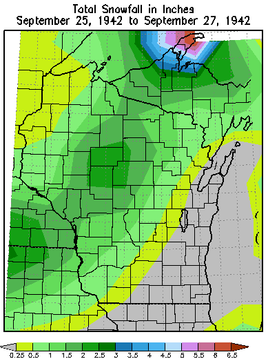
Unprecedented snow fell on the 26th and 27th. Traces were generally found across southeastern part and in the river valleys of southwest Wisconsin. Meanwhile 1 to 6 inches of snow fell across the remainder of the state. The highest snowfall totals were reported at Tomahawk (5.7 inches) and Deerskin Dam (6.3 inches). The average snowfall for the state was 0.8 inches. The previous highest average for September was 0.1 inches in September 1899, 1908, and 1913.
Michigan...
On the 26th and 27th, unusually early snow fell across almost all parts of the state. Much of the snow melted as it fell. However, snowfall totaling more than 2 inches were reported at several stations in Upper Michigan and a few locations in northern lower Michigan. The greatest accumulated snowfall occurred at Dukes (8 inches).
Indiana...
On the 25th and 26th, measurable snow fell across the northeast part of the state. The heaviest totals was 4.0 inches in LaPorte and Wheatfield.
Snowfall
Location State Total
-------- ----- --------
Grand Meadow MN 5.0 inches
Medford WI 4.5 inches
Austin MN 4.0 inches
Neillsville WI 4.0 inches
Spring Grove MN 4.0 inches
Waukon IA 3.5 inches
Mauston WI 3.2 inches
Stanley WI 3.2 inches
Blair WI 3.0 inches
Lewiston MN 3.0 inches
St Charles MN 3.0 inches
Cresco IA 2.5 inches
New Hampton IA 2.5 inches
Mather WI 2.0 inches
Reads MN 2.0 inches
Elkader IA 1.5 inches
Hillsboro WI 1.5 inches
Postville IA 1.5 inches
Fayette IA 1.0 inches
Osage IA 1.0 inches
Viroqua WI 1.0 inches
Charles City IA 0.4 inches
Rochester MN 0.3 inches
La Crosse WI 0.2 inches
Winona MN 0.2 inches
Decorah IA Trace
Hatfield WI Trace
Lancaster WI Trace
Mondovi WI Trace
Oelwein IA Trace
Richland Center WI Trace
Wisconsin Dells WI Trace
Sparta WI Trace


 Follow us on YouTube