|
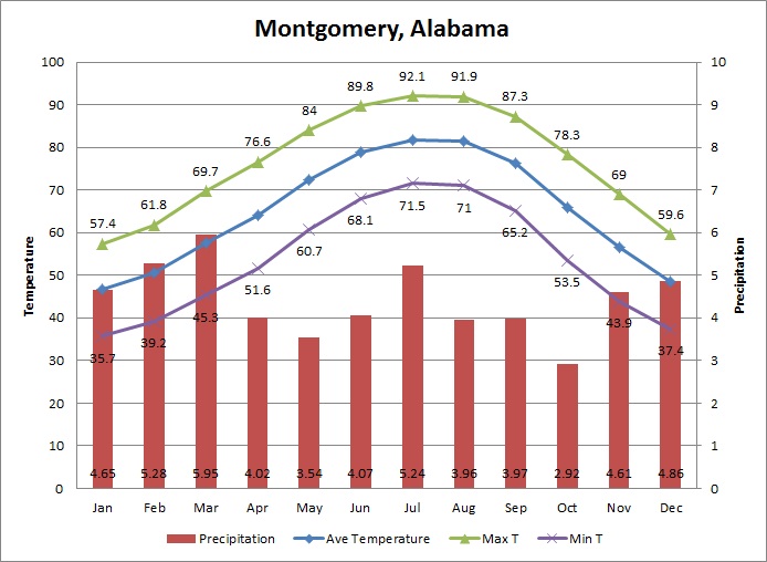
Montgomery is located in a gently rolling area of Alabama with no local topographic features which appreciably influence weather and climate. Surrounding terrain is rather level with long gentle slopes toward the northeast and east. The Alabama River bends along the northwest side of the city. During the months of June through September, inclusive, temperature and humidity conditions generally show little change from day to day. During the coldest months, December, January, and February, there are frequent shifts between mild and moist air from the Gulf of Mexico and dry, cool continental air. From late June through the first half of August, nearly all precipitation is from local, mostly afternoon, thunderstorms, and there are apt to be considerable differences in day-to-day amounts of rainfall in different parts of the Montgomery area. In late August and in September, summer conditions of temperature and humidity persist as air continues to drift in from the Gulf, but local thunderstorms become less frequent because of the shortening of the days and the decrease in heat received from the sun. As this late summer season progresses, the local thunderstorms give way to thunderstorms which occur with cold fronts and occasional general rains associated with storms on the Gulf. All types and intensities of rain, except the local thunderstorms of summer, may occur at any time from December through March or early April. Floods in the rivers are correspondingly most frequent during this period. Most rain from late April through early June is in the form of showers or thunderstorms occurring in advance of approaching cool fronts, which become weaker and less frequent as summer approaches. It is during this spring season, and during the late summer and early autumn, that droughts sometimes occur. Snow in Montgomery is important only as a curiosity.
|
|
|


 Follow us on YouTube