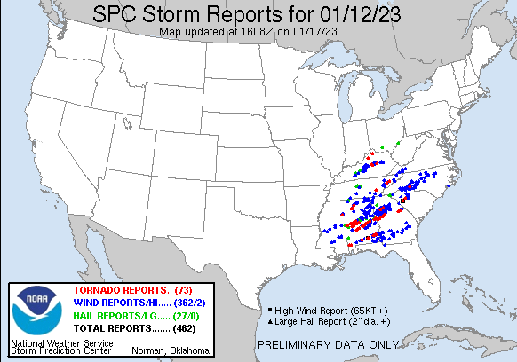
National Weather Service United States Department of Commerce


Tornadoes of March 30, 2022

Overview
 

Numerous strong to severe thunderstorms impacted Central Alabama during the morning and afternoon hours of Thursday, January 12th, 2023. Several supercell thunderstorms spawned multiple tornadoes which caused significant damage in many areas. The severe thunderstorms also produced damaging straight-line winds and hail up to golf ball size.


View Larger Map

 
Surveys
 

**The data below are considered PRELIMINARY.**

 
Location/Clickable Detailed Summary Link
Damage Rating/Estimated Maximum Wind Speeds
Injuries/Fatalities
Damage Path Length/Width
Starting Point/Time
Ending Point/Time
Delmar Tornado
(Winston County)
EF-2
125 mph
None 9.18 miles
425 yards
1 E Delmar
34.1658/-87.5864
8:05 am CST
3 SE Ashridge
34.2040/-87.4334
8:18 am CST
Emelle Tornado
(Sumter County)
EF-2
120 mph

 
1 Injury 12.87 miles
440 yards
2 W Emelle
32.7288/-88.3463
9:24 am CST
3 SSE Gainesville
32.7715/-88.1314
9:40 am CST
Eutaw Tornado
(Greene, Hale, Tuscaloosa and Bibb Counties)
EF-2
130 mph
None 38.76 miles
600 yards
1 W Eutaw
32.8420/-87.9158
9:54 am CST
1 WNW Harmon
33.0390/-87.2940
10:43 am CST
Greensboro Tornado
(Hale and Perry County)
EF-2
115 mph
None 21.98 miles
500 yards
2 S Duffys Bend
32.6221/-87.7543
10:47 am CST
1 ESE Morgan Springs
32.7427/-87.4061
11:15 am CST
Fire Tower Road Tornado
(Perry and Bibb Counties)
EF-1
105 mph
None 17.34 miles
500 yards
1 SE Ellards
32.8027/-87.2421
11:30 am CST
2 NE Talladega National Forest
32.8965/-86.9672
11:51 am CST
Selma Tornado
(Dallas County)
EF-2
130 mph
2 Injuries 23.22 miles
950 yards
1 NE Orville
32.3173/-87.2278
12:04 pm CST
2 SE Burnsville
32.4575/-86.8721
12:31 pm CST
Old Kingston-Lake Martin Tornado
(Autauga, Elmore, Coosa, Tallapoosa and Chambers Counties)
EF-3
150 mph
7 Fatalities
16 Injuries
82.31 miles
1500 yards
4 SSW Vida Junction
32.5212/-86.7312
12:40 pm CST
1 E Penton
33.0069/-85.4552
2:08 pm CST
Standing Rock Tornado
(Chambers County)
EF-2
130 mph
None 12.62 miles
1600 yards
1 WSW White Plains
32.9871/-85.4131
2:08 pm CST
2 E Standing Rock
33.0742/-85.2257
2:24 pm CST
Teals Crossroads Tornado
(Barbour County)
EF-1
105 mph
None 10.96 miles
900 yards
1 S Doster
31.6251/-85.6726
3:25 pm CST
1 E Blue Springs State Park
31.6616/-85.4934
3:38 pm CST
 
Delmar EF-2
 

Delmar EF-2 Tornado (Winston County)
  January 12, 2023


Event Summary

EF-2
Estimated Maximum Wind:
125 mph
Injuries/Fatalities:
None
Damage Path Length:
9.18 miles
Maximum Path Width:
425 yards
Approximate Start Point/Time:
1 E Delmar
34.1658/-87.5864
at 8:05 am CST
Approximate End Point/Time:
3 SE Ashridge
34.2040/-87.4334
at 8:18 am CST


The tornado touched down east of Delmar near County Rd 20 where timber damage was observed in addition to minor structural damage. The tornado continued northeast into a heavily wooded area near Tanyard Creek then crossing County Rd 28 where trees were uprooted. The width here was approximately 150 yards wide. The tornado continued northeast into additional heavily wooded areas near Clear Creek then impacting a residence on County Rd 432 uprooting and snapping trees, causing structural damage, and overturning an RV. The tornado continued to grow in width as it moved northeast, approximately 425 yards wide as it crossed Macedonia Rd. The tornado continued to cause additional timber damage in a heavily wooded area before it impacted a farm near County Rd 55 and 3182. Here the highest degree of damage occurred as two large chicken coops were completely destroyed in addition to 3 other small farm buildings. Nearby structural damage occurred to at least 4 residences. Adjacent timber damage also occurred. The tornado continued east-northeast toward Highway 195 where it dissipated before crossing County Rd 6. Around 25 structures were damaged due to the tornado.

NWS Birmingham would like to thank Darone and Mike (NWS Memphis) and Alabama Law Enforcement Agency (ALEA) for their assistance with this survey.  

Tornado Track Map


Radar Image
Reflectivity (left) and velocity (right).
Images are from KGWX at 8:07 am CST.


Damage Photo
 Chicken house destroyed.
Damage Photo
 Chicken house destroyed.
Damage Photo
 Manufactured home destroyed.
Damage Photo
 Camper tossed.
 
Emelle EF-2
 

Emelle EF-2 Tornado (Sumter County)
  January 12, 2023


Event Summary

EF-2
Estimated Maximum Wind:
120 mph
Injuries/Fatalities:
1 Injury
Damage Path Length:
12.87 miles
Maximum Path Width:
440 yards
Approximate Start Point/Time:
2 W Emelle
32.7288/-88.3463
at 9:24 am CST
Approximate End Point/Time:
3 SSE Gainesville
32.7715/-88.1314
at 9:40 am CST


This tornado began near Sumter 24 uprooting trees. The tornado continued east-northeast along Sumter 24 where it destroyed a grain bin near Ramsey Lane along with snapping and uprooting a few more softwood trees. The tornado moved through Emelle where it caused damage to roofs in the community along with uprooting and snapping numerous trees. The tornado crossed Highway 74 and took the roof off of a home and destroyed an outbuilding near the intersection of Highway 74 and Sunlight Church Road. The tornado was at it`s strongest intensity at this point with a max wind of 120 mph. The tornado crossed Highway 39 and destroyed a mobile home on Hodges Place Road. The tornado ended just east of Sumter 21 uprooting and snapping a few more trees along the way. At least 3 dozen structures suffered varying degrees of damage.

NWS Birmingham would like to thank Dan (NWS Jackson) for the assistance with this survey. 

Tornado Track Map


Radar Image
Reflectivity (left) and velocity (right).
Images are from KGWX at 9:25 am CST.
 
Damage Photo
 Significant timber damage.
Damage Photo
 Manufactured home destroyed.
 
Eutaw EF-2
 

Eutaw EF-2 Tornado (Greene/Hale/Tuscaloosa/Bibb Counties)
  January 12, 2023


Event Summary

EF-2
Estimated Maximum Wind:
130 mph
Injuries/Fatalities:
None
Damage Path Length:
38.76 miles
Maximum Path Width:
600 yards
Approximate Start Point/Time:
1 W Eutaw
32.8420/-87.9158
at 9:54 am CST
Approximate End Point/Time:
1 WNW Harmon
33.0390/-87.2940
at 10:43 am CST


This tornado began just west of West End Avenue and moved across West End Avenue where it destroyed a shed, caused roof damage, snapped and uprooted trees. The tornado continued to move into the northern portions of Eutaw where it snapped and uprooted numerous trees along with minor roof damage to several homes. Trees also fell on at least 2 homes causing significant damage to the homes. A rooftop observation deck was taken off of one home and thrown across the street off of Ashby Drive. The tornado continued east-northeast before ending just east of Highway 11 snapping and uprooting several trees along the way. Additional survey work determined the tornado continued northeast after crossing US Hwy 11 in Greene County, moving into the Oak Village area of Hale County near Lock 8 Boat Landing on the Black Warrior River. Tree damage could be seen on both sides of the river from Lock 8. Most significant damage was on the Hale County side along Flemming Rd and Oak Village Road. Many mobile homes were destroyed on Flemming Rd, mostly due to tree fall. Tree fall consisted of hardwood trees being snapped or uprooted. One home in Oak village sustained significant damage after garage failure occurred. This resulted in adjacent walls collapsing and most of the roof structure being blown north into the river. Additional timber and varying degrees of structural damage was observed to the end of Oak Village Rd. This survey was somewhat difficult as this exact area was damaged by an EF1 tornado just 6 weeks ago. The tornado continued northeast, but is believed to have weakened or skipped along its path. Only minor timber damage was found near Stewart and up to Hwy 69. However, more significant timber damage was found downstream on County Rd 50, entering the Talladega National Forest. Hardwood trees were snapped and uprooted with a path width around 300 yards at this point as the tornado seemingly strengthened. The tornado then continued over the Elliott`s Creek EF3 path from March 25th, 2021 before crossing into Tuscaloosa County where high-end timber damage was observed. The path here was nearly 600 yards wide with the center portion consisting of most trees snapped at their base, generally 200 yards wide or more. The rating here was assigned 130 mph, high-end EF2. The tornado continued northeast crossing US Hwy 82 near Hagler causing additional timber damage and some minor structural damage at two homes. It is believed the tornado weakened and dissipated thereafter, generally north of US Hwy 82 in western Bibb County. This area was not accessible. At least 60 structures suffered varying degrees of damage.​ 

Tornado Track Map


Radar Image
Reflectivity (left) and velocity (right).
Images are from KGWX at 9:54 am CST.
 
Damage Photo
 Tree and roof damage.
Damage Photo
 Tree damage and camper flipped.
 
Greensboro EF-2
 

Greensboro EF-2 Tornado (Hale & Perry Counties)
  January 12, 2023


Event Summary

EF-2
Estimated Maximum Wind:
115 mph
Injuries/Fatalities:
None
Damage Path Length:
21.98 miles
Maximum Path Width:
500 yards
Approximate Start Point/Time:
2 S Duffys Bend
32.6221/-87.7543
at 10:47 am CST
Approximate End Point/Time:
1 ESE Morgan Springs
32.7427/-87.4061
at 11:15 am CST


The tornado touched down in a remote area of Hale County, near Clements Bend on the Black Warrior River. From there, it moved east-northeast across CR-35, where downed numerous trees on a farm near the State Cattle Ranch. From there, it continued to snap and uproot numerous trees in a largely rural area, before causing considerable damage to the roof of a house along AL-69. The tornado grew to EF-2 strength as it approached the southern part of the city Of Greensboro. At AL-25, it snapped and uprooted numerous trees, rolled and destroyed a single-wide manufactured home, and caused lighter damage to several other structures. The remaining damage along the path was mostly to timber, including along AL-61 just southeast of Greensboro, and AL-14 just east of the city. The tornado then weakened to high EF-0 to low EF- 1 strength as it moved into Perry County near Griffin Cemetery Road, and ultimately dissipated after snapping off its final few trees on Morgan Springs Road. At least 30 structures suffered varying degrees of damage.

Tornado Track Map


Radar Image
Reflectivity (left) and velocity (right).
Images are from KBMX at 10:57 am CST.
 
Damage Photo
 Manufactured home destroyed.
Damage Photo
 Debris and tree damage.
 
Fire Tower Rd EF-1
 

Fire Tower Road EF-1 Tornado (Perry & Bibb Counties)
  January 12, 2023


Event Summary

EF-1
Estimated Maximum Wind:
105 mph
Injuries/Fatalities:
None
Damage Path Length:
17.34 miles
Maximum Path Width:
500 yards
Approximate Start Point/Time:
1 SE Ellards
32.8027/-87.2421
at 11:30 am CST
Approximate End Point/Time:
2 NE Talladega National Forest
32.8965/-86.9672
at 11:51 am CST


The tornado began near the Cahaba River west of National Forest Road 401D (NF-401D) and Barton Road based on radar estimation of a TDS. It developed quickly into a high end EF-0 by the time it brushed Double Branch Rd as it moved east-northeasterly over the forest. As it crossed Fire Tower Road, it reached maximum EF-1 intensity of 105 mph based on scores of snapped and uprooted pine trees right on the ridge. The tornado continued over forested land before crossing Pawtucky Road, where several pines and hardwoods were snapped. The tornado then began to weaken as it approached and crossed Alabama Highway 219 north of the Bibb/Perry county line. The decaying tornado continued eastward across U.S. Highway 82, where storm chaser video showed a weak circulation crossing the highway. Dissipation occurred about one mile east of the highway.

Tornado Track Map


Radar Image
Reflectivity (left) and velocity (right).
Images are from KBMX at 11:31 am CST.
 
Damage Photo
 Timber damage.
Damage Photo
 Timber damage.
 
Selma EF-2
 

Selma EF-2 Tornado (Dallas County)
  January 12, 2023


Event Summary

EF-2
Estimated Maximum Wind:
130 mph
Injuries/Fatalities:
2 Injuries
Damage Path Length:
23.22 miles
Maximum Path Width:
950 yards
Approximate Start Point/Time:
1 NE Orville
32.3173/-87.2278
at 12:04 pm CST
Approximate End Point/Time:
2 SE Burnsville
32.4575/-86.8721
at 12:31 pm CST


National Weather Service surveys have concluded that the damage across Dallas County was consistent with a high-end EF-2 tornado. The tornado began just east of Orrville near the intersection of Hwy 22 and Cahaba Rd. As it moved northeast, it intensified as the damage path was nearly parallel with Hwy 22. The damage consisted of mainly uprooted trees with some trunks that were snapped. There were also several manufactured homes that sustained roof and some foundation damage. As the tornado continued down Hwy 22, additional tree damage was observed as it neared the southwestern sections of Selma.

The tornado quickly intensified as it entered the city limits of Selma, nearly parallel to Hwy 22/W Dallas Ave. The overall length and width of the EF1 to EF2 damage in the densely populated neighborhoods had devastating impacts to the city. Many hardwoods were uprooted and softwood trees were snapped, many on homes. Most of the softwood trees were snapped about halfway up on the trunks. The daycare on W Dallas Ave and Cooper Dr sustained heavy roof and exterior wall damage which was consistent with the higher-end EF2 wind speeds. Some debris rowing was also noted in the downstream vicinity. Over 70 children, infants, and workers survived without injury by taking shelter in small interior rooms and bathrooms after getting the warning, while portions of the roof collapsed over large open classrooms and the former sanctuary. The second area of higher-end EF2 damage was noted downstream at the Selma Country Club where buildings had significant roof and exterior wall damage and there was a complete blow down of extremely large hardwood trees. Additional softwood trees were also snapped in and around adjacent streets.

As the tornado continued further north and east, it entered the northern sections of downtown Selma. Much of the damage continued to consist of downed trees, some on homes, but several homes near the center of the track had roofs removed consistent with continued EF2 damage. Another notable area of high-end EF2 damage was where Broad Street crosses the railroad tracks. Here a strip mall had much of its roof removed, and some of the X-braces in a metal building system failed, which from a structural engineering perspective was one of the more impressive damage indicators for the tornado. A couple older residences collapsed near the intersection of Minter Street and St. Phillip Street, but as they were built on brick pilings with open air underneath the rating was kept in the EF2 range.

As the tornado exited downtown, it crossed Hwy 14, east of Selma, crossing Parkway Dr. Additional structure damage was noted with exterior walls that collapsed consistent once again with higher EF-2 wind speeds. The tornado finally began to weaken and lift just east near the Brantley community near River Rd, but not before some significant damage was observed at the Dallas County Jail on Selfield Rd.


Tornado Track Map


Radar Image
Reflectivity (left) and velocity (right).
Images are from KBMX at 12:18 pm CST.


Damage Photo
 Significant timber damage.
Damage Photo
Daycare damaged. 
Damage Photo
 Significant structural damage.
Damage Photo
Multiple homes damaged. 
Damage Photo
 Structural damage.
Damage Photo
Significant timber damage. 
 
Old Kingston-Lake Martin EF-3
 

Old Kingston-Lake Martin EF-3 Tornado (Autauga, Elmore, Coosa, Tallapoosa & Chambers Counties)
  January 12, 2023


Event Summary

EF-3
Estimated Maximum Wind:
150 mph
Injuries/Fatalities:
7 Fatalities / 16 Injuries
Damage Path Length:
82.31 miles
Maximum Path Width:
1500 yards
Approximate Start Point/Time:
4 SSW Vida Junction
32.5212/-86.7312
at 12:40 pm CST
Approximate End Point/Time:
1 E Penton
33.0069/-85.4552
at 2:08 pm CST


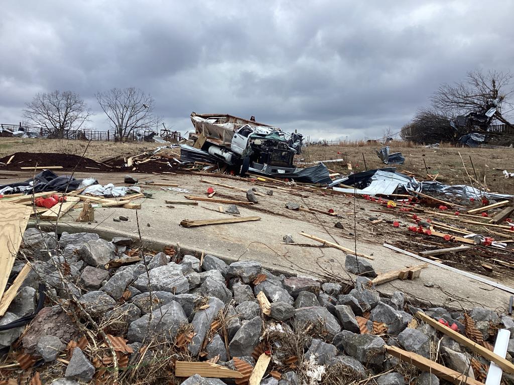
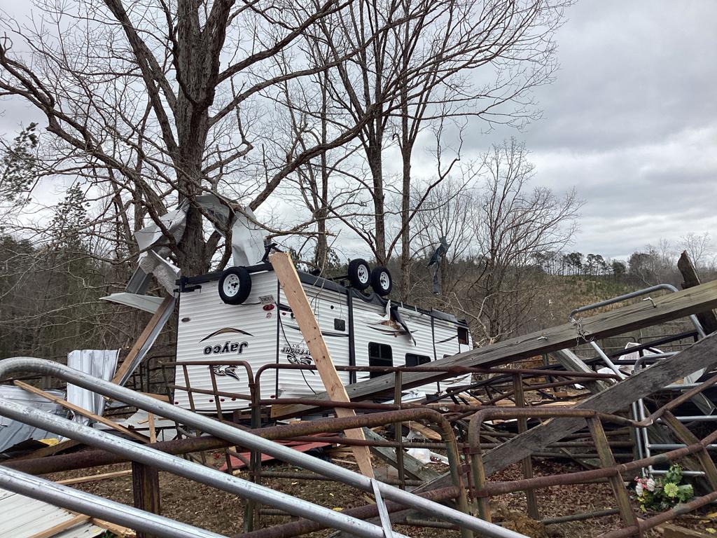
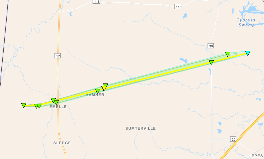
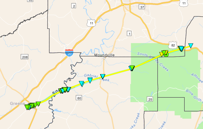
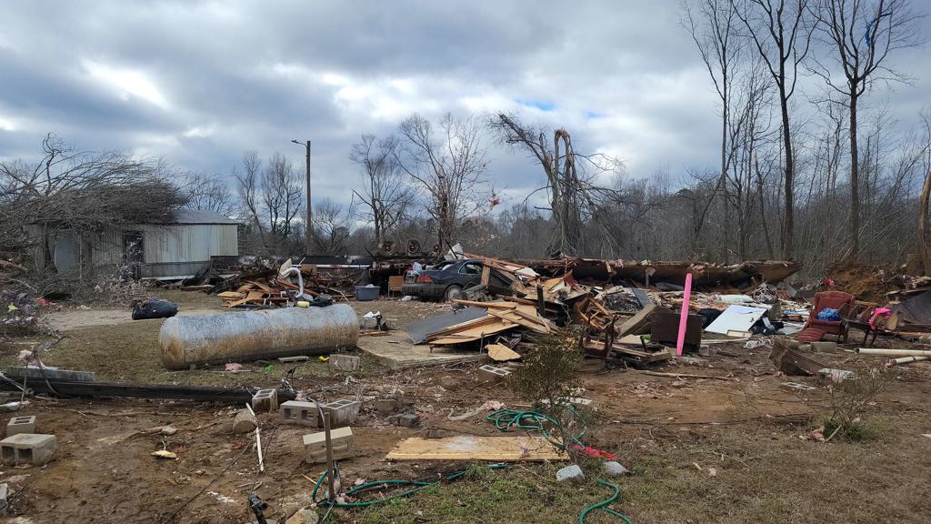
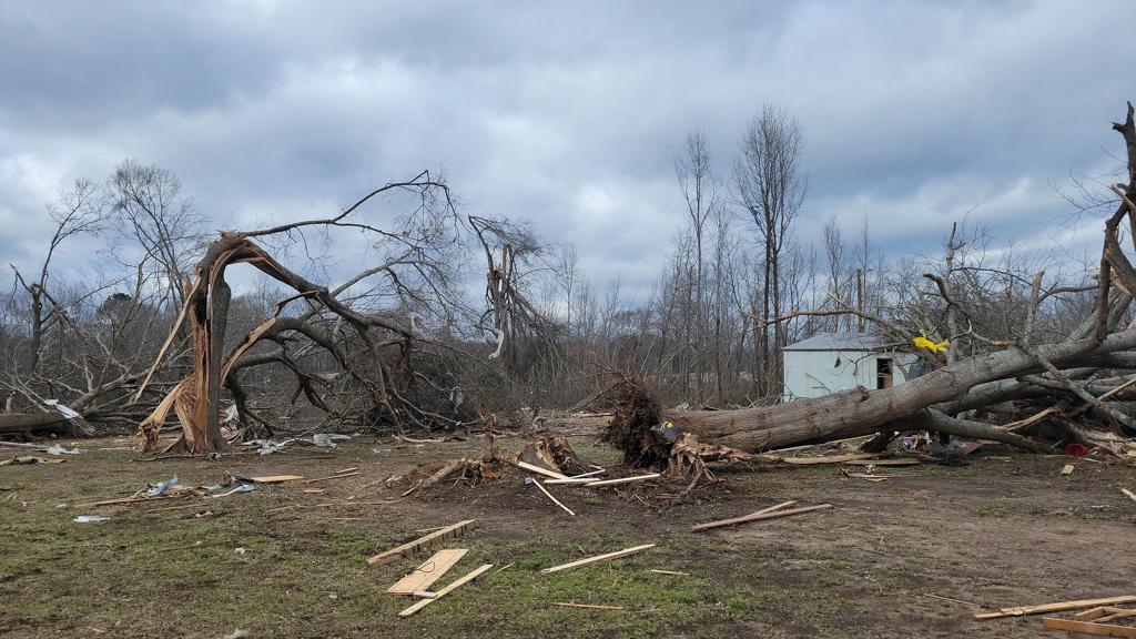
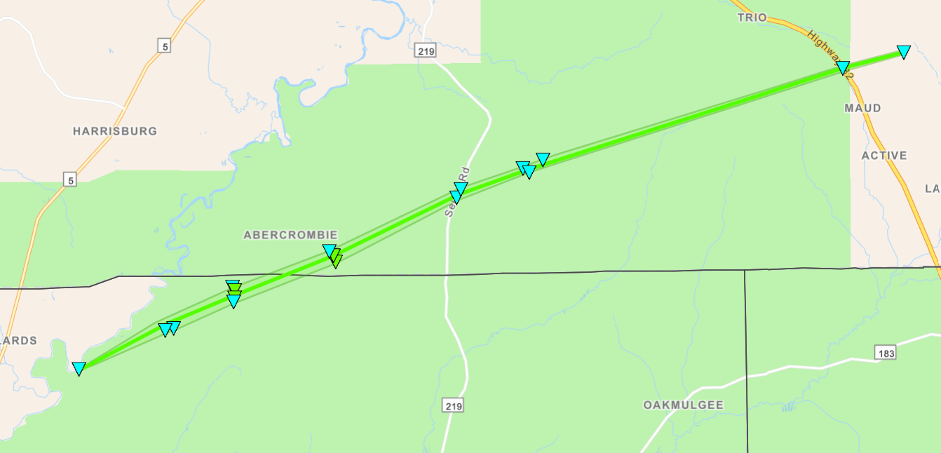
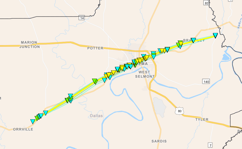
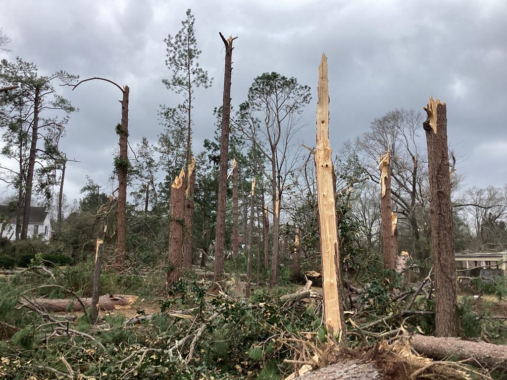
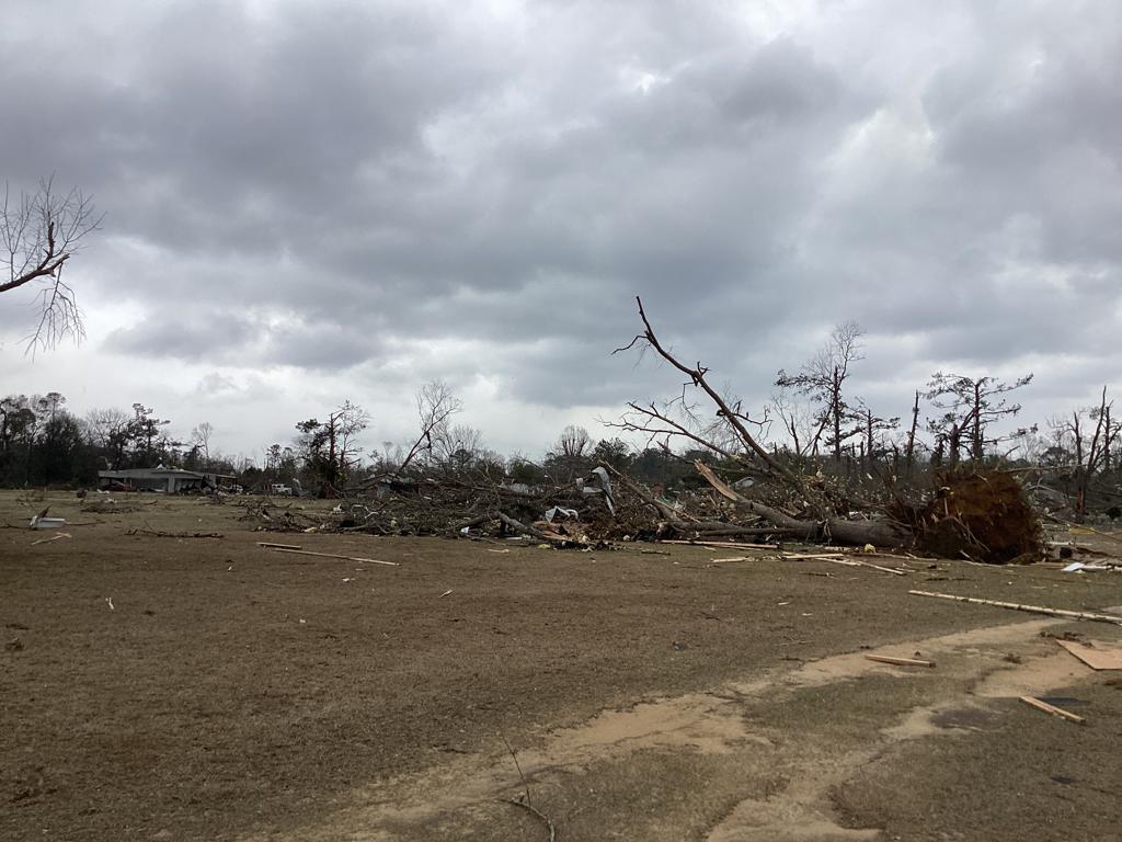
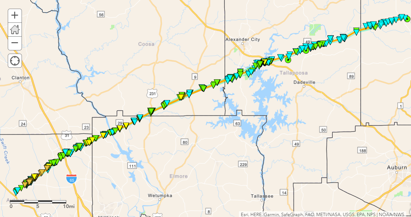
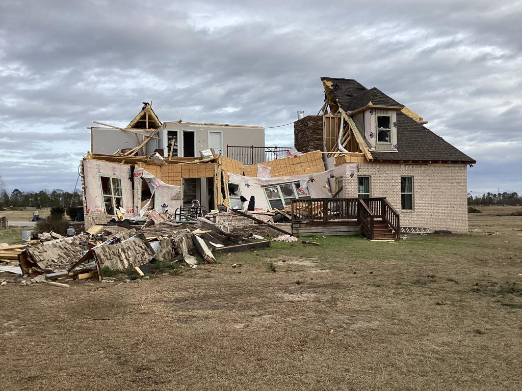
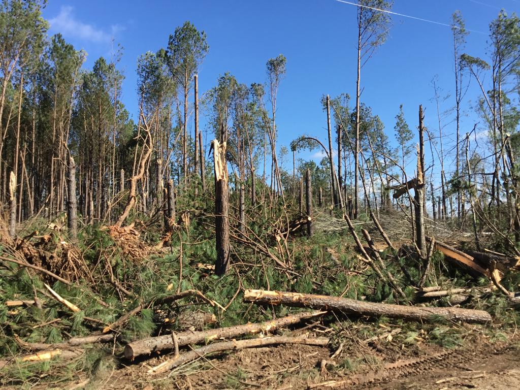
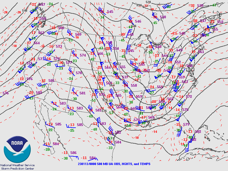
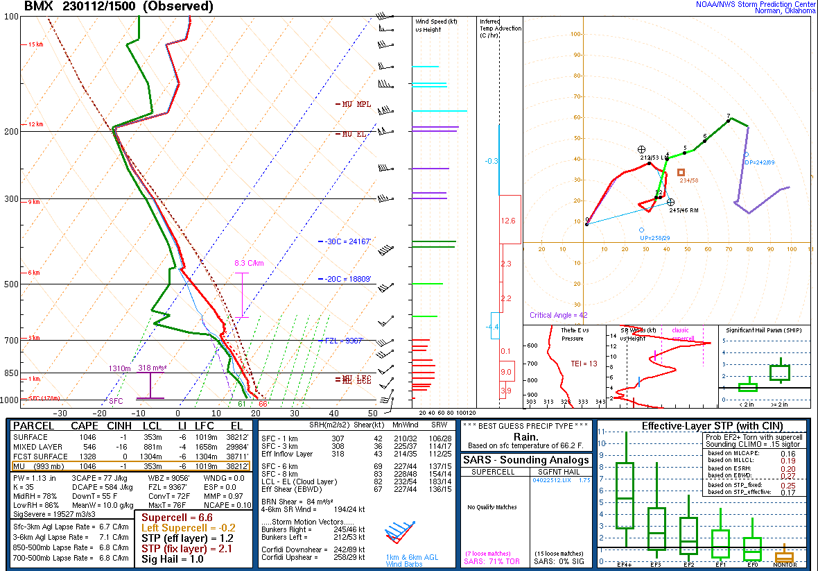
This long-track tornado began west of U.S. Highway 82, where timber damage occurred to farms near Independence. The tornado crossed U.S. Highway 82 and strengthened as a manufactured home was rolled along Autauga County Road 40. Over the next two miles, the tornado rapidly strengthened as it approached the Old Kingston community, where EF-3 damage began along County Road 43. At this location, at least three manufactured homes were obliterated with their frames thrown up to 100 yards. A pickup truck was sent airborne and landed 120 yards to the northeast, where a shallow crater was formed by its impact. The tornado became deadly as it impacted several homes along Sandy Ridge Road. The frame of a manufactured home at the western end of the road was thrown 250 yards to the north-northeast and came to rest in a field. Just downstream, several manufactured homes in a cluster were shredded and thrown considerable distances. Trees were snapped off relatively close to the ground and partially debarked. In total, five fatalities occurred along Sandy Ridge Road at three separate residences. Similar damage continued to the northeast along County Road 140, where a total of two fatalities occurred in two separate residences at the eastern end of the road. At least five manufactured homes were blown away with their frames thrown considerable distances. Several vehicles were picked up and thrown, and one pickup truck had its cab separated from the bed. From this area to the northeast to County Rd 42, the tornado caused massive tree damage and what appeared to be stands of debarked trees along Autauga Creek. In the three mile stretch of most severe damage from County Road 43 to County Road 42, wind speeds reached at least 150 mph. Based on the damage scene and contextual evidence, it is plausible that winds were stronger. However, with only manufactured homes in the path, there appear to be no damage indicators that will allow a higher rating. The tornado moved across County Road 57 at a slightly weaker state, where numerous trees were snapped and uprooted with several homes sustaining significant roof damage with one site-built home also sustaining partial wall failure.

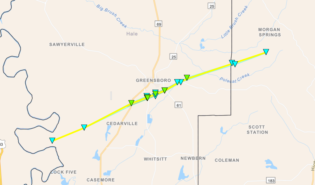
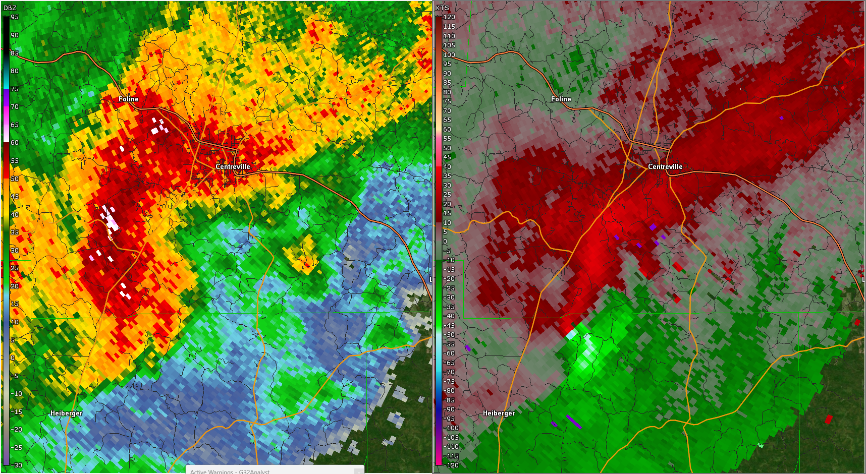
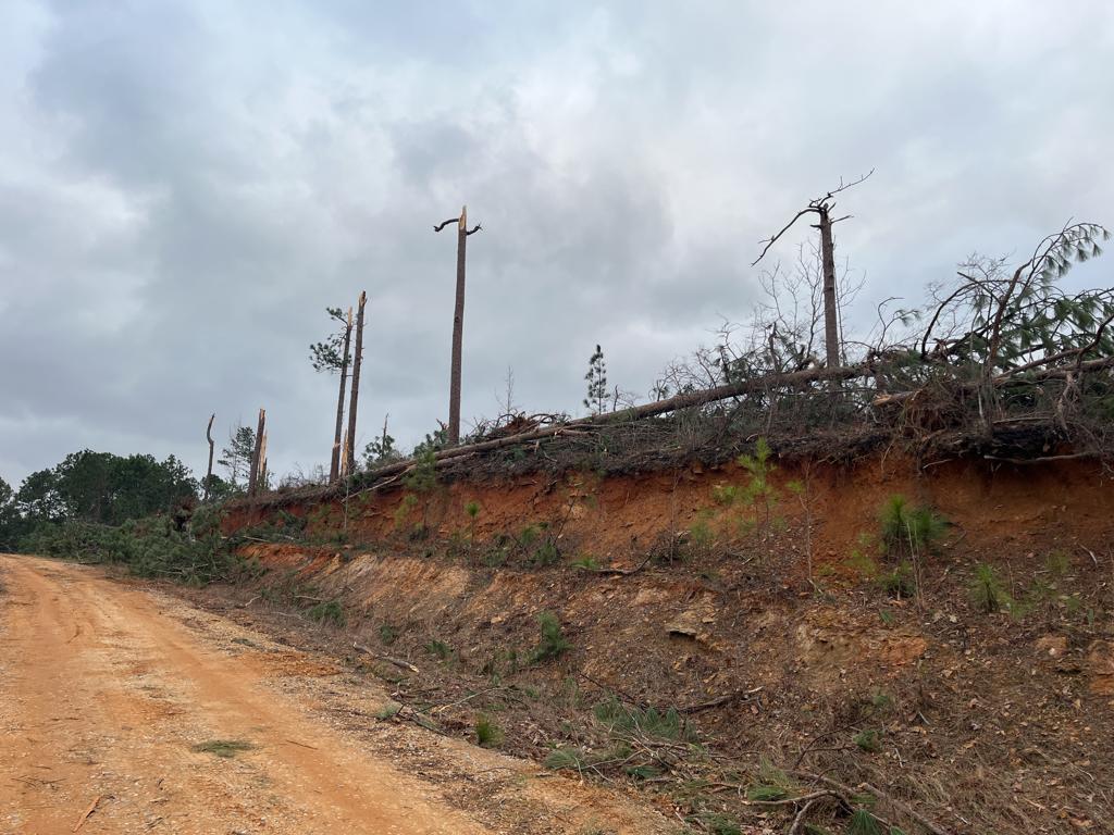
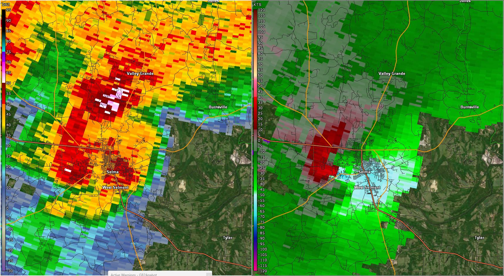
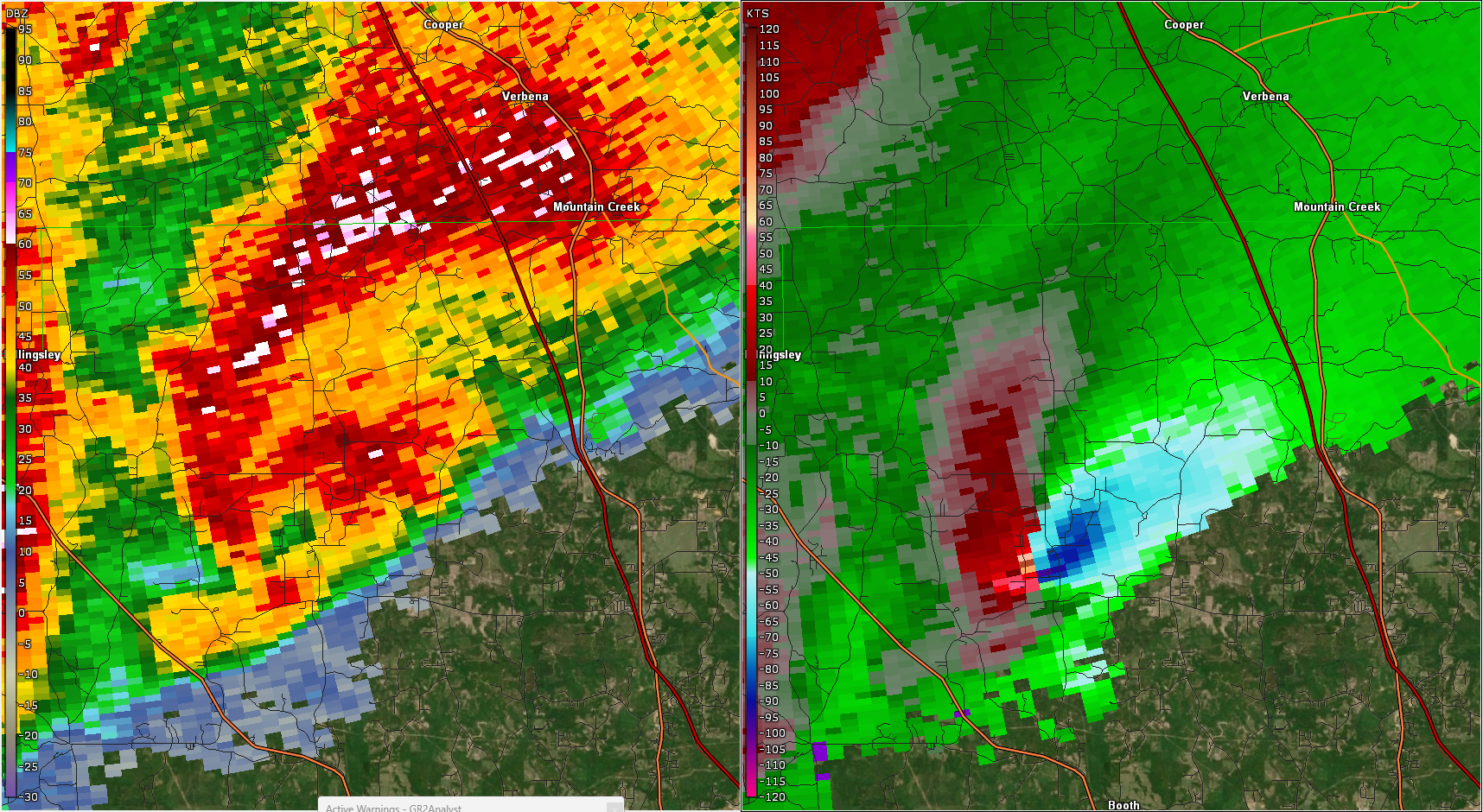
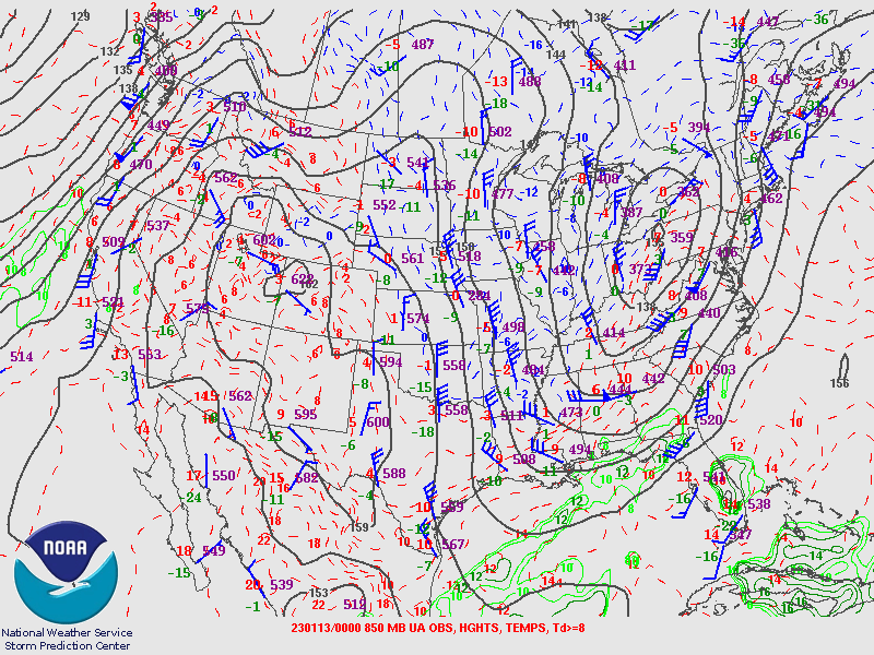
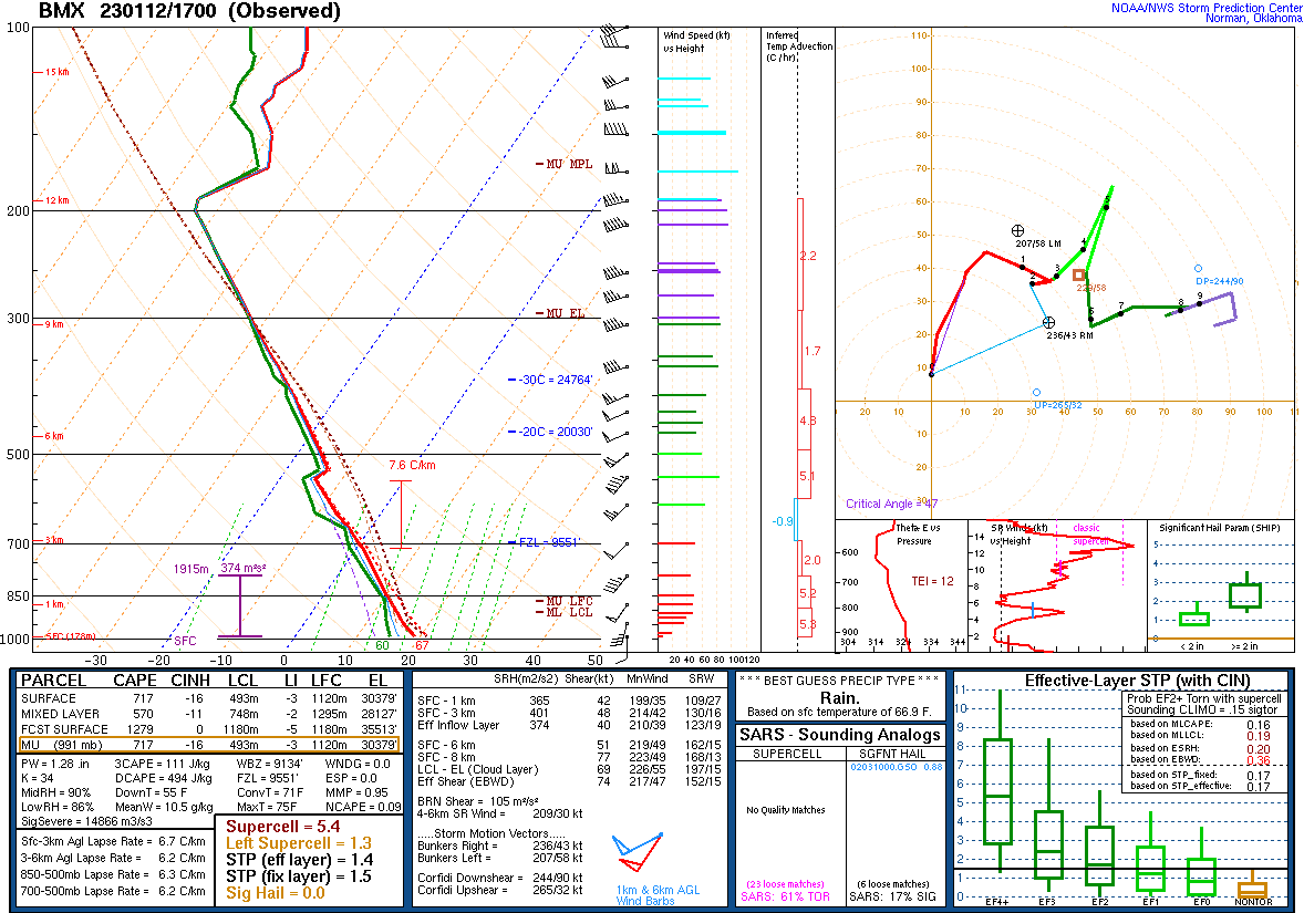
The tornado crossed Interstate 65 where trees were downed. In the Pine Level community, several homes sustained roof damage and a manufactured home was rolled off its foundation and onto County Road 68 E. Many trees were uprooted and snapped as the tornado crossed through the Pine Flat community. Additional homes sustained roof damage and other damage from fallen trees, and a manufactured home was rolled and destroyed. Residential structure damage intensified as the tornado neared the Autauga/Elmore county line where site-built homes sustained majority or entire roof removal along County Road 68 E near Poplar Springs Road. Similar residential structure damage was observed in northwest Elmore County as the tornado neared areas west of the Coosa River. The tornado then crossed the Coosa River, affecting Neely Road on the west bank and Kelly Road on the east bank, as well as nearby roads. As the tornado crossed Grays Ferry Road on the northeast side of Titus, the volume of snapped pine trees increased notably. Countless trees were snapped and uprooted as the tornado moved northeastward toward the Elmore/Coosa county line at Highway 231. Structural damage continued to consist of roof uplift or removal and damage from wind-blown debris and fallen trees. Radar showed a debris ball in southern Coosa County which matched ground observations of a truly extensive area of snapped pine trees at and on either side (downstream and upstream) of the southern portion of McKissick Road, located between the communities Speed and Equality. The volume of snapped trees was enough to assign an EF-3 rating for this segment of the tornado`s path. Additional significant damage occurred along County Road 18 where vehicles were moved or flipped, numerous trees were snapped, and site-built homes were heavily damaged with one destroyed. This was another area assigned EF-3 intensity. The tornado continued northeastward toward the Coosa/Tallapoosa county line where additional, relatively less intense timber damage was noted.

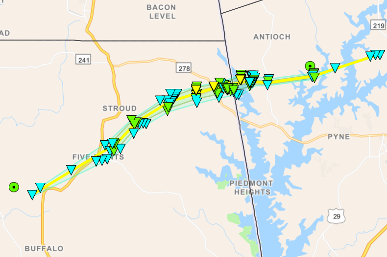
Tornado damage continued into Tallapoosa County with a corridor of timber damaged observed along Cedar Creek and Elkahatchee Roads. Timber was snapped and uprooted and consistent with EF-1 damage here. The tornado continued northeast crossing Highway 63 S approaching the Wind Creek State Park area. Timber damage was observed here. The tornado then moved toward Coven Abbett Road and then Elbert Road. Several homes sustained damage here, some significant with roofs blown off, boat houses destroyed, and adjacent significant timber damage as dozens of large hardwood trees were snapped and uprooted. Areas impacted near here were Elbert Drive, Loblolly Lane, and Elbert Rd. The tornado then crossed the northern section of Lake Martin before impacting additional lakefront homes. Numerous homes were damaged on River Run Road and the adjacent side streets. Some homes sustained significant damage with entire roofs blown away and exterior walls collapsed or removed. At least two home were shifted from their foundation. The high-end EF-2 damage here could be partly due to the interaction of the tornado with the lake surface, as well as the exposed nature of these homes since most structures inland seemed to be "sheltered" from adjacent heavily wooded areas. The tornado also damaged homes along Lake Ridge Drive. The tornado continued northeast causing pockets of EF-1 timber damage as it crossed US Highway 280. The tornado then moved across the rest of Tallapoosa County causing mainly varying degrees of timber damage in the EF-0 to EF-1 range, including the Sessions area. The tornado continued northeast into Chambers County causing additional swaths of mainly timber damage in the EF-0 to EF-1 range. The tornado began its final weakening stage as it neared Highway 77, dissipating shortly after crossing County Road 114.

Tornado Track Map


Radar Image
Reflectivity (left) and velocity (right).
Images are from KBMX at 12:50 pm CST.


Damage Photo
 Home significantly damaged.
Damage Photo
Debris and significant timber damage. 
Damage Photo
 Manufactured home destroyed.
Damage Photo
Manufactured home destroyed. 
Damage Photo
 Significant timber damage and car tossed.
Damage Photo
Extensive timber damage. 
Damage Photo
 Home significantly damaged.
Damage Photo
Pickup truck cab separated from bed. 
 
Standing Rock EF-2
 

Standing Rock EF-2 Tornado (Chambers County)
  January 12, 2023


Event Summary

EF-2
Estimated Maximum Wind:
130 mph
Injuries/Fatalities:
None
Damage Path Length:
12.62 miles
Maximum Path Width:
1600 yards
Approximate Start Point/Time:
1 WSW White Plains
32.9871/-85.4131
at 2:08 pm CST
Approximate End Point/Time:
2 E Standing Rock
33.0742/-85.2257
at 2:24 pm CST


NWS meteorologists have surveyed damage in northeastern Chambers County and determined it was consistent with an EF2 tornado. The start point was a bit uncertain due to sporadic timber damage around Five Points, but appears to be near County Road 114 west of Highway 431 to the southwest of Five Points. Northeast of Five Points, the tornado intensified, snapping and uprooting many trees along County Road 267 and causing roof damage to a barn. The swath of timber damage became almost a mile wide along County Roads 281 and 282 and at least one residence there suffered roof damage. The tornado continued to intensify as it crossed County Road 268 where large swaths of pine trees were snapped. A manufactured home was completely destroyed and blown downstream near County Road 278; thankfully the family was not home at the time. Most of the structural damage happened along County Road 284. A couple residences suffered significant shingle damage, one had siding damage, and a manufactured home had its porch ripped off, impacting its walls. Another manufactured building was blown off its footings. Another significant swath of snapped pines was observed on County Road 283, some snapped off only a couple feet off the ground. The tornado then crossed into Georgia, continuing to snap trees along West Point Lake.

Tornado Track Map


Radar Image
Reflectivity (left) and velocity (right).
Images are from KMXX at 2:15 pm CST.
 
Damage Photo
 Manufactured home destroyed.
Damage Photo
 Significant Timber damage.
 
Teals Crossroads EF-1
 

Teals Crossroads EF-1 Tornado (Barbour County)
  January 12, 2023


Event Summary

EF-1
Estimated Maximum Wind:
105 mph
Injuries/Fatalities:
None
Damage Path Length:
10.96 miles
Maximum Path Width:
900 yards
Approximate Start Point/Time:
1 S Doster
31.6251/-85.6726
at 3:25 pm CST
Approximate End Point/Time:
1 E Blue Springs State Park
31.6616/-85.4934
at 3:38 pm CST


The tornado initially touched down near Bethel on Sutton Dairy Rd Causing timber damage near Buck Branch. The tornado continued northeast into a heavily wooded area and caused continued timber damage near Dewey Ivey Rd, snapping numerous pines. Additional damage downstream occurred near farm structures near Huey Faulk Rd. A home sustained damage due to a fallen tree on County Rd 15. The tornado continued northeast towards Teals Crossroads where additional timber damage occurred near Roberts Rd. Some minor structural damage was observed. The tornado continued east-northeast crossing County Rd 33 and Turner Rd before dissipating near Highway 10.

NWS Birmingham would like to thank Molly and Karleisa (NWS Tallahassee) for their assistance with this damage survey.


Tornado Track Map


Radar Image
Reflectivity (left) and velocity (right).
Images are from KEOX at 3:27 pm CST.
 
Damage Photo
 Timber damage.
Damage Photo
 Home damaged by fallen tree.
 
Outlooks & Reports
 

Day 3 Outlook
Local Day 3 Outlook
January 10 at 230 am

Day 2 Outlook
Local Day 2 Outlook
January 11 at 4 am

Day 1 Outlook
Local Day 1 Outlook
January 11 at 1130 pm

Storm Reports
Storm Reports
January 12th

   
Surface Charts
 

Surface Chart
Surface Analysis
January 12 at 6 am

Surface Chart
Surface Analysis
January 12 at 9 am

Surface Chart
Surface Analysis
January 12 at 12 pm

Surface Chart
Surface Analysis
January 12 at 3 pm

Surface Chart
Surface Analysis
January 12 at 6 pm

Upper Air Charts
 

250 mb
250 mb Analysis
January 12 at 6 am

500 mb
500 mb Analysis
January 12 at 6 am

850 mb
850 mb Analysis
January 12 at 6 am

250 mb
250 mb Analysis
January 12 at 6 pm

500 mb
500 mb Analysis
January 12 at 6 pm

850 mb
850 mb Analysis
January 12 at 6 pm

KBMX Sounding
KBMX Sounding
January 12 at 6 am

KBMX Sounding
KBMX Sounding
January 12 at 9 am

KBMX Sounding
KBMX Sounding
January 12 at 11 am

KBMX Sounding
KFFC Sounding
January 12 at 12 pm