Severe Weather Events of February 27, 1999
National Weather Service Meteorologists surveyed some of the more extensive damage from severe weather that occurred on the evening of February 27th, 1999. Those events are described here. All of these weather events occurred during the passage of a squall line with a nearly solid line of thunderstorms. Within the squall line, numerous thunderstorms exhibited bow-like characteristic which was the trigger for many of the warnings. Click on the images to get a larger picture.
 A brief tornado, rated F2 on the Fujita Scale, occurred about 3.5 miles northwest of Locust Fork around 7:15 PM. The tornado crossed county road 13 moving in a northerly direction. Two or three large barns were demolished, a sturdy brick home lost
  a portion of its roof, and a small wood frame was completely deroofed. One minor injury occurred in the wood frame house. Several large hay bales were strewn across county road 13 and two vehicles were nearly blown off the road. Numerous trees in the area were uprooted or snapped off.
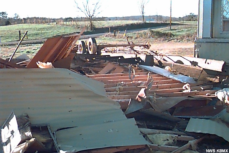
The tornado track was estimated to be 50 yards wide and about three tenths of a mile long.
What was believed to be strong straight line wind destroyed two mobiles and severely damaged a third about one mile south of nectar. This event occurred around 7:20 PM.
A Severe Thunderstorm Watch was in effect at the time of these events. A Severe Thunderstorm warning was issued for blount county at 6:58 PM valid until 7:45 PM.
 There were numerous reports of wind damage from last Saturday evening in Etowah county. One of the hardest hit areas was at the Stowers manufacturing company plant in Gadsden...and the residential area to the immediate west. There was significant roof damage in the 3 or 4 block area...and numerous trees were uprooted or snapped off. The structure of the damage suggests this was a straight-line wind event. This event occurred around 7:55 PM.
A Severe Thunderstorm Warning was in effect from 7:25 PM to 8:15 PM.
Another area surveyed was about 4 miles south of Southside...and 1 mile west of Highway 77...on the banks of Neely Henry Lake...in extreme southern Etowah county. Several trees were uprooted in the area...and the roof was blown off of 1 mobile home. There was minor damage done to surrounding structures. The structure of the damage and personal interviews suggest this was an F0 tornado...with a path length of 0.3 mile...and a width of 50 yards. This event also occurred around 7:55 PM.
A Severe Thunderstorm Warning was in effect from 7:25 PM to 8:15 PM.
Strong straight line wind downed several trees in the graysville area including one pine tree that fell on a house on 10th avenue southwest. Five people including two children and three adults sustained injury when the tree came through the roof around 7:00 PM.
A Severe Thunderstorm Watch was in effect and a Severe Thunderstorm Warning was issued for Jefferson county at 6:37 PM valid until 7:25 PM.
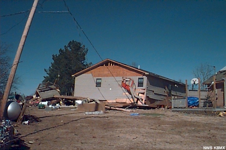 A tornado occurred around 5:55 PM about 4 miles northeast of Killen in northern Lauderdale county. A mobile home was destroyed, several houses were heavily damaged, numerous trees were downed and uprooted, and several other structures sustained minor damage. The tornado path was 175 yards wide and about 1.7 miles long. Based on the damage surveyed, the tornado was rated an F2 on the Fujita Scale.
Additional damage occurred in Lauderdale county about 4.5 miles south of Lexington. Here strong straight line wind downed several trees and caused minor roof damage to several structures. Shingles were disturbed on several houses.
A Severe Thunderstorm Watch was in effect and a Severe Thunderstorm Warning was issued at 6:03 PM valid until 6:50 PM.
 Significant wind damaged occurred in north St. Clair county...along County Road 24...in the Oldham Chapel Church area. This is approximately
 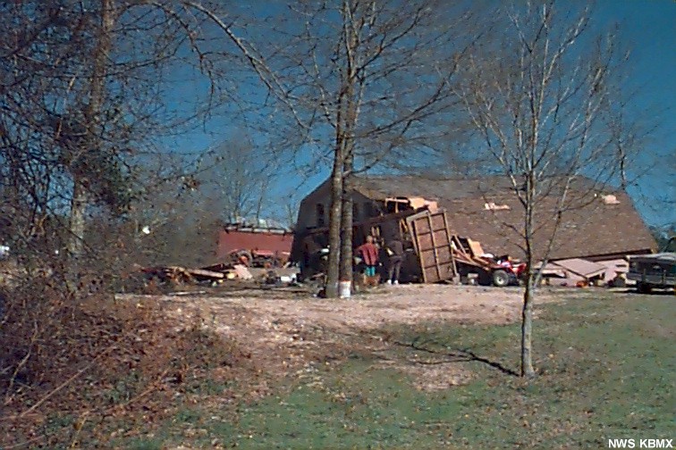 6 to 8 miles northeast of Ashville. The damaged area was about 2 miles in length...where hundreds of trees were uprooted or snapped off. The roof of a church was partially blown off near the beginning of the track. One house had half of its roof blown off and a garage/apartment building was blown off its foundation. Several mobile homes also sustained damage. The damage suggests this was a strong straight-line wind event. Radar and personal interviews indicate this event occurred around 7:45 PM.
A Severe Thunderstorm Warning was in effect from 7:10 PM to 8:00 PM.
The first event in Winston county occurred about 4 miles northwest of Double Springs about 6:23 PM. Strong straight line wind damaged a house by removing about 100 square feet of roof was removed. Additional structural damage was evidenced in the house as well. A number of trees were also downed in the area and a mobile home was shifted slightly on it's blocks.
The second event in Winston county occurred around 6:25 PM when a weak tornado touched down about 3.5 miles south-southwest of Double Springs just west of state road 195. A tree fell on a garage/workshop, numerous trees were downed, a storage shed was destroyed, and a mobile home suffered minor roof damage. The tornado path was about 30 yards wide and about half a mile long. It was rated an F0 on the Fujita Scale of tornado intensity.
A Severe Thunderstorm Watch was in effect at the time of the events but no warning was issued.


 Follow us on YouTube