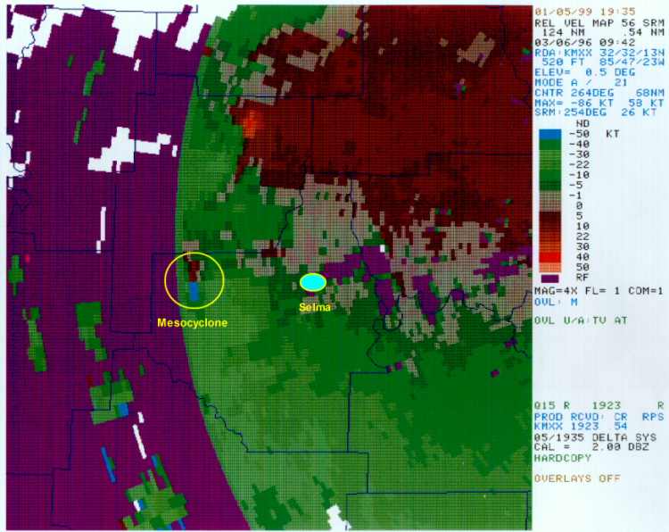
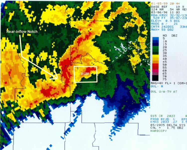
The Central Alabama Tornadoes of 6 March 1996Kevin J. Pence, John T. Bradshaw, and Mark W. RoseNational Weather Service, Birmingham, Alabama (Paper published in the AMS Preprints of the 19th Conference on Severe Local Storms 14-18 September 1998 - Minneapolis, Minnesota) 1. INTRODUCTION Six tornadoes, two of which were deadly, formed over central Alabama during the predawn hours of 6 March 1996. The two killer tornadoes are known as the Selma Tornado (F3) and the Montgomery Tornado (F2). The Selma Tornado began at 0942 UTC and tracked 31 km to the northeast (Fig. 1). It hit the northwestern section of Selma, killing four people and injuring forty. The Montgomery Tornado was produced by a different thunderstorm and was the last of four tornadoes associated with a bow/comma echo structure (Fujita 1978). It began at 1120 UTC in eastern Montgomery and traveled east for 6 km, killing two people and injuring seventeen. The early morning severe weather of 6 March 1996 occurred 8 - 12 hours earlier than anticipated. No part of Alabama was within the slight risk area of the day 1 Severe Weather Outlook issued at 1930 UTC on 5 March by the Storm Prediction Center (SPC) (Fig. 2). An updated outlook issued at 0130 UTC on 6 March included northwest Alabama in the slight risk area for the overnight hours, but was still centered over eastern Arkansas and northern Mississippi. 2. SYNOPTIC AND MESOSCALE FEATURES A broad upper-level trough covering the western U.S. on 5 March amplified over the next 24 hours as it progressed eastward. A quasi-stationary surface front extended from a surface low in northern Texas into the middle Mississippi Valley. A vigorous vorticity maximum accompanied the upper-level trough as it swept eastward toward Alabama. Well in advance of the main upper-level trough and strongest dynamics, a weaker short-wave trough moved across northern Mississippi and Alabama between 0000 and 1200 UTC 6 March. Showers and thunderstorms increased rapidly over north-central Alabama in response to the advancing short-wave trough. Rainfall amounts of 1 to 3 inches were common across this area overnight, producing flash flooding in several counties (Fig. 3). A distinct boundary formed along the southern edge of the rain mass, with rain-cooled air on its north side. South of the boundary, surface data from Montgomery, Alabama (KMGM) and vertical wind profiles from the Maxwell AFB WSR-88D (KMXX) showed a southerly wind of 10 kt at the surface to 45 kt at 1 km. Warm, moist air (surface temperatures and dew points 65 to 70F) spread northward producing a zone of low-level convergence along the boundary. Vertical wind profiles were favorable for supercell formation. The 24-hour forecast of storm-relative helicity (0-3 km) from both the Eta and NGM models, verifying at 1200 UTC 6 March, indicated values of 250 to 300 m2 s-2 in a zone across central Mississippi and Alabama. The 1200 UTC 6 March model runs verified helicity values of 180 to 300 m2 s-2 across this area. The 1200 UTC 6 March Birmingham (KBMX) sounding was north of the boundary. Using surface conditions from KMGM and Velocity Azimuth Display (VAD) winds from KMXX, the KBMX sounding was modified to give a better representation of atmospheric conditions south of the boundary. Convective Available Potential Energy (CAPE) values in the unmodified sounding were 267 J kg-1, and increased to 821 J kg-1 when modified. Storm-relative helicity in the unmodified sounding was 342 m2 s-2, but an incredible 539 m2 s-2 when modified. The boundary between the rain-cooled air to the north and the warmer, moist air to the south was an important factor in the generation of severe thunderstorms well outside the severe weather outlook area. The boundary created a zone of convergence and enhanced wind shear. The mean sea-level pressure at KMGM fell 7 mb from 0300 to 0900 UTC. It is suspected the significant pressure falls in the area were associated with the upper-level short-wave trough, the concentrated and persistent warm advection, and mesolows that propagated eastward along the boundary. 3. SELMA TORNADO The severe thunderstorm which spawned the Selma tornado originated within a large area of showers and thunderstorms which covered west-central Alabama during the predawn hours. This convection was benign through most of the night, with no severe weather reported. However, shortly before 0900 UTC, the Selma thunderstorm began to develop and move eastward along the southern edge of the large-scale rain mass. Initially, the storm's appearance on radar was very nondescript (Fig. 4), with few indications that it was destined to become tornadic. Supercellular characteristics were almost totally absent: no bounded weak echoes, tight reflectivity gradients, or overhangs were observed in the reflectivity products, and no deep rotation was present in the velocity data. Significantly, however, the southern end of the storm did exhibit persistent low-level rotation up to 45 minutes prior to the touchdown of the tornado, as evidenced by WSR-88D velocity data. Figure 5 contains Rotational Velocity (Vr) values derived from KBMX 0.5 Storm Relative Motion (SRM) products before and during the Selma tornado episode. Low-level rotation was weak during the early stages of the storm, as evidenced by a Vr of only 20 kt at 0903 UTC. However, these values increased steadily during the next 30 minutes, reaching 42 kt by 0929 UTC. Occurring at a range of 93 km, this intensity of circulation implied the presence of a strong mesocyclone within the storm by this time. During the last 15 minutes prior to tornado formation, the Selma storm began to reveal some additional signs of impending severity. The low-level mesocyclone continued to strengthen, with a Vr exceeding 50 kt at the time of tornado touchdown (0942 UTC) (Fig. 6). The circulation also appeared to deepen with time, displaying increasing amounts of shear at the 1.5 and 2.4 elevation angles between 0929 and 0942 UTC. The storm's reflectivity pattern also underwent significant changes during this time period, as seen in Figure 7. Along the southeastern edge of the storm, the low-level reflectivity gradient tightened along the flank of the mesocyclone. Some overhang was also discernable in this region, with high reflectivities suspended 4 - 6 km above the circulation center. Meanwhile, a subtle comma-shaped feature was developing at the north end of the storm, approximately 25 km away, with moderate amounts of rotational velocity present at the two lowest elevation angles. No severe weather was reported with this comma-head vortex, due likely to the fact that it occurred in an extremely unpopulated area largely comprised of National Forest land. However, as noted by Fujita (1978), and recently by Pfost and Gerard (1997), features such as this are often associated with the development of weak tornadoes. Shortly after the tornado touched down in western Dallas County, the parent mesocyclone reached its maximum Vr intensity of 64 kt. The first independent confirmation that a tornado was on the ground was a " lockout report " from a local electric company, indicating that a set of primary high voltage power lines had been snapped. A few minutes later the tornado moved through the northwest side of Selma, killing four people. Shortly after this occurred, the storm began to weaken, with Vr values dropping to 41 kt about the time the tornado dissipated. 4. MONTGOMERY TORNADO As the Selma storm weakened, clusters of thunderstorms to the immediate south rapidly evolved into a 100 km long squall line. By 1051 UTC, the southern half of the squall line took the shape of a Line Echo Wave Pattern (LEWP). Updrafts were strengthening as evident in increasing radar reflectivities between 3 and 6 km. Between 1057 and 1103 UTC, a significant bowing line segment and associated rear-inflow notch (Przybylinski 1995) developed over northwestern Montgomery County, or just west of the city of Montgomery (Fig. 8). There was also a well-defined WER on the leading edge of the bow. A low- to mid-level mesocyclone developed at this time just north of the rear-inflow notch, at the southern tip of the rotating head of a comma echo. The mesocyclone was fully engulfed in precipitation at the lowest elevation (0.5 - 1 km) as it tracked to the east at 55 kt. This high speed appeared to be the sum of the MCS translational speed (~40 kt) and the rotational speed of the comma echo (~15 kt). At 1114 UTC, the Vr of the low-level mesocyclone increased to 36 kt at the lowest radar elevation (< 1 km). The velocity couplet was just over 1 km in diameter, resulting in a shear value of 22 x 10-3 s-1. At 1120 UTC, the time of the F2 Montgomery Tornado, Vr was 35 - 40 kt in the lowest 5 radar elevations (< 1 - 3 km). There was a complicated damage path of weak tornadoes and downbursts across the city of Montgomery associated with this mesocyclone from 1112 to 1120 UTC. The killer F2 tornado at 1120 UTC coincided with the descent of the rear-inflow jet to the lowest radar elevation, as evident by the rear-inflow notch (Fig. 9). It was also at this time that the rear-inflow notch became totally surrounded by the high reflectivities of the bow echo and the comma head echo. The two fatalities occurred as the tornado moved through a mobile home park just east of the Montgomery city limits. There was no known damage associated with the bow echo; the damage was all confined to the trailing, rotating comma-head echo. 5. SUMMARY AND CONCLUSIONS Severe weather, including several weak tornadoes and one strong tornado, did occur within the SPC slight risk areas of 5/6 March 1996. The numerical weather prediction models accurately projected an increase in vertical wind shear (helicity) over central Alabama, where the instability was much weaker than that in the risk areas. However, a rain-induced mesoscale thermal boundary in the same general area of strong vertical wind shear combined to create a favorable environment for severe thunderstorms over central Alabama. It is critical to monitor areas for developing mesoscale boundaries when other factors are favorable for severe weather. Few, if any, classic severe thunderstorm reflectivity signatures were associated with the Selma storm. This F3 tornado represents the most intense Alabama tornado to date with such poor associated WSR-88D reflectivity signatures. It would have been impossible to warn for this storm without the Doppler velocity data. The Montgomery Tornado was associated with a rapidly developing and evolving squall line, LEWP, bowing line segment, and comma-head echo structure (Przybylinski 1995). All of the known damage was confined to the mesocirculation at the southern tip of the comma-head echo. Due to the close proximity of KMXX, the low-level and small scale velocity couplet was detected by radar. This feature can easily be missed at slightly longer ranges. Our experience with a bowing line segment that evolves into a comma-head echo has been either weak to strong tornadoes, or very significant straight-line wind damage, will occur with this mesoscale convective system. 6. REFERENCES Fujita, T.T., 1978: Manual of downburst identification for Project NIMROD. Satellite and Mesometeorology Research Paper 156, Department of Geophysical Sciences, University of Chicago, 104 pp. Pfost, R. L., and A. E. Gerard, 1997: " Bookend Vortex " induced tornadoes along the Natchez Trace. Wea. Forecasting, 12, 572-580. Przybylinski, R. W., 1995: The bow echo: observations, numerical simulations, and severe weather detection methods. Wea. Forecasting, 10, 203-218. |


 Follow us on YouTube