|
National Weather Service meteorologists had an opportunity to survey the damage caused by the tornado that struck Columbus, GA, on the afternoon of March 13, 1997. The original survey, done Friday March, 14th, has been updated by new information. Additional surveying done late Friday, revealed additional 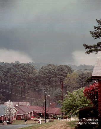 damage in the Pierce Chapel Road area and slightly into Harris County. The information below has been updated. Note: to view a larger image of the pictures contained on this page, just click on the image. damage in the Pierce Chapel Road area and slightly into Harris County. The information below has been updated. Note: to view a larger image of the pictures contained on this page, just click on the image.
The photo (left) is of the Columbus, GA, tornado, March 13, 1997. The picture was taken by Richard Thomason, Ledger-Enquirer. The photographer was looking east-southeast toward the tornado as it moved northeast from the airport.
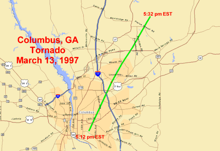
The tornado produced a nearly continuous path (map of damage path) of damage from the southside of Columbus diagonally across the city on a northeasterly track crossing the northeast side of Columbus and 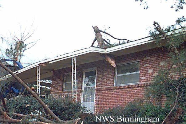 the J. R. Allen Parkway. The tornado dissipated approximately one mile into Harris County. No deaths occurred with the tornado and only one injury, a broken arm, had been reported. On the Fujita classification scheme, this tornado was rated an F1 with wind speeds estimated in the range from 73 to 113 mph. The tornado track was approximately 10.25 miles in length with a maximum width of about 150 yards. Tornadoes are rated based on the maximum intensity and much of the damage actually fell in the F0 category. the J. R. Allen Parkway. The tornado dissipated approximately one mile into Harris County. No deaths occurred with the tornado and only one injury, a broken arm, had been reported. On the Fujita classification scheme, this tornado was rated an F1 with wind speeds estimated in the range from 73 to 113 mph. The tornado track was approximately 10.25 miles in length with a maximum width of about 150 yards. Tornadoes are rated based on the maximum intensity and much of the damage actually fell in the F0 category.
The tornado apparently began at 5:12 pm EST on the southside of Columbus first touching down on  Martin Luther King Boulevard where a business was partially deroofed. The tornado moved northeastward through primarily residential sections such as Wynnton Grove, Averett Woods and Hilton Heights. Damage in these areas was primarily to trees and power lines. Martin Luther King Boulevard where a business was partially deroofed. The tornado moved northeastward through primarily residential sections such as Wynnton Grove, Averett Woods and Hilton Heights. Damage in these areas was primarily to trees and power lines.
The tornado crossed Interstate 185 in the vicinity of Columbus College. Hardaway High School suffered roof damage to the gymnasium as well as damage to the athletic field and equipment. A couple of portable classrooms at Columbus College were destroyed, one being thrown across Interstate 185.
The tornado continued northeastward across the Peachtree Mall and the Columbus airport. Relatively minor damage was done in these areas. The observation equipment at the Columbus airport reported a wind gust to  58 knots, or 67 miles an hour, at 5:23 pm EST. Damage increased as the tornado moved into the residential areas of Wayne Terrace, Windsor Park, and Lyn Hills located north of the airport. Tornado intensity seemed to be stronger in this area though damage continued to be primarily to trees with many trees falling on houses. A number of houses sustained roof damage from the wind as well, but only a few actually lost portions of their roofs because of the wind. 58 knots, or 67 miles an hour, at 5:23 pm EST. Damage increased as the tornado moved into the residential areas of Wayne Terrace, Windsor Park, and Lyn Hills located north of the airport. Tornado intensity seemed to be stronger in this area though damage continued to be primarily to trees with many trees falling on houses. A number of houses sustained roof damage from the wind as well, but only a few actually lost portions of their roofs because of the wind.
The tornado continued northeast through the North Oaks, Charter Oaks, and Bridlewood residential areas with only minor damage to trees and minor damage to house tops - generally shingles blown off. The tornado  crossed the J. R. Allen Parkway just to the south- southwest of Shaw High School. Additional damage in the form of downed trees occurred on Pierce Chapel Road at the Muscogee/Harris county line. The damage to trees continued approximately one mile into Harris County before the tornado dissipated completely. The tornado had ended by 5:32 pm EST. crossed the J. R. Allen Parkway just to the south- southwest of Shaw High School. Additional damage in the form of downed trees occurred on Pierce Chapel Road at the Muscogee/Harris county line. The damage to trees continued approximately one mile into Harris County before the tornado dissipated completely. The tornado had ended by 5:32 pm EST.
A Tornado Warning was issued for Muscogee County at 4:54 pm EST, approximately 18 minutes prior to the initial touchdown of the tornado. Columbus-Muscogee County EMA sounded the warning sirens at 4:55 pm EST with the warning issuance and again around 5:10 pm EST with reports of a funnel cloud from police officers.
More Images
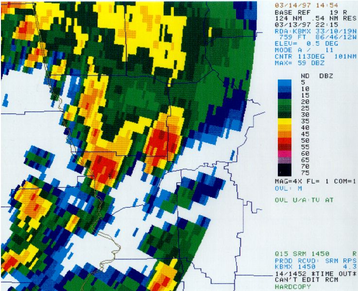
Radar pictures are scanned images of printouts and are during the time of tornado event.
|


 Follow us on YouTube