|
Tornado and Large Scale Hail/Wind Event on March 18, 2013
|
|
An intense line of thunderstorms, known as a derecho, moved through central Alabama during the afternoon and evening hours of Monday, March 18th. Interestingly enough, the morning started out cloudy across Alabama, but as dry air aloft filtered into the state from the southwest, the clouds thinned, allowing surface based instability to increase into the 1250-1750 J/kg range ahead of the developing line of thunderstorms. As the line entered the state from Mississippi, it brought with it damaging straight line winds of widespread reports of 60 to 80 mph, including a measured report of 88 mph. These winds resulted in trees and power lines down across the northern two-thirds of central Alabama. Along with the wind from the derecho, up to two inch hail was reported and eventually a tornado spun up in northern Etowah County. Ahead of the derecho, discrete thunderstorms developed as well. It was within these individual storms where some of the largest hail was reported, including baseball sized hail in Chilton County. The information below is preliminary and may need to be updated as new information becomes available.
|
|
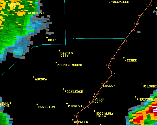
Sardis City (Etowah) EF-1 Tornado
|
|
|
EF-1
|
|
Estimated Maximum Wind:
|
95-105 mph
|
|
Injuries/Fatalities:
|
3 |
|
Damage Path Length:
|
7.9 miles
|
|
Maximum Path Width:
|
300 yards
|
|
Approximate Start Point/Time:
|
34.1987/-86.1061 at 343 pm
|
|
Approximate End Point/Time:
|
34.1913/-86.0144 at 348 pm
|
|
|
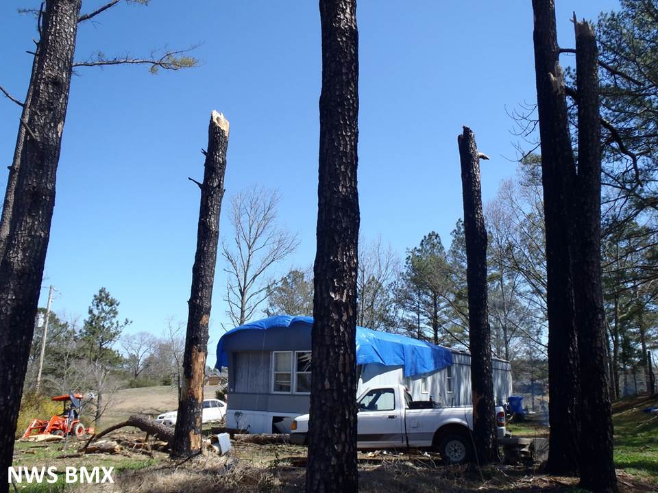
National Weather Service meteorologists have surveyed damage in northern Etowah County and determined it was the result of an EF-1 tornado with maximum winds of 95-105 mph. The tornado initially touched down in Marshall County in Boaz and moved eastward into Etowah County about a half of a mile west of Oak Drive where it snapped and uprooted several pine trees. From there it moved to the east and crossed Broadwell Road and overturned a tractor trailer and a camper. The tornado continued eastward, snapping and uprooting trees along the path. Several barns and small outbuildings sustained roof damage. As the tornado crossed Chumley Road, two mobile homes were overturned while more trees were uprooted. The most extensive damage occurred as the tornado approached Rowen Road. A mobile home was lifted and overturned leaving one person seriously injured and two others with minor injuries. In this same area, two additional mobile homes were destroyed. As the tornado crossed Brow Road, a one story brick home had one third of its roof removed and wind-blown debris was observed on all four sides of the home. The tornado continued further east for approximately 300 yards before dissipating as it approched Sand Valley Road.
|
|
0.5 degree reflectivity loop from KHTX from 338 pm to 347 pm. This is just before touchdown to just before the tornado lifted.
|

0.5 degree SRM velocity loop from KHTX from 338 pm to 347 pm. This is just before touchdown to just before the tornado lifted.
|
|
Tornado Damage Images - Click to Enlarge
|
|
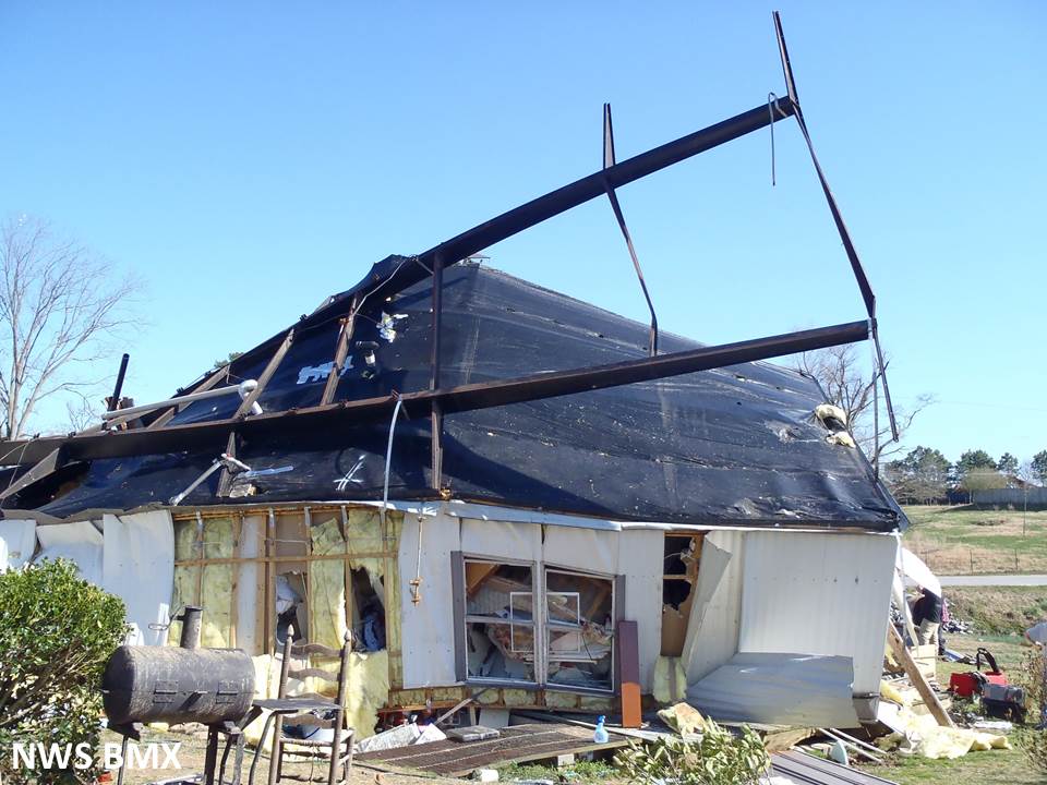
Mobile home frame tossed on top of neighboring home
|

Mobile home anchors pulled from ground and broken straps
|
|
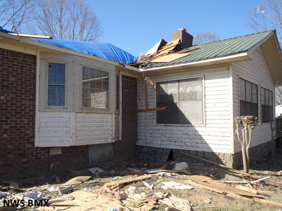
Two parts: 1. Notice the leave and dirt splatter on the side of the house.
|

2. Opposite side of house has splatter, too, which when coupled with the image to the left, is indicative of a tornado
|
|

Mobile homes tossed over 150 yards. Debris from mobile home strewn through the field
|
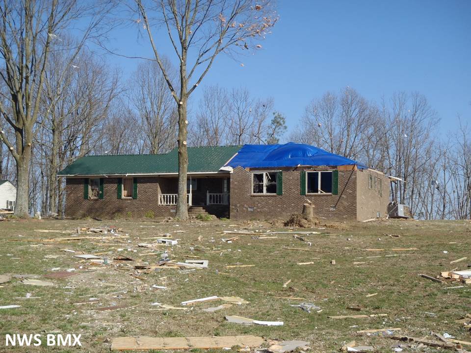
Partial roof removal of a well-built home. This is one indication of a middle to high-end EF-1
|
|
Thunderstorm Wind Damage - West Etowah County
|
|
With the widespread nature of wind damage reports in central Alabama, it is impossible to survey them all. Based on reports and pictures from county emergency managers, some spots need to be surveyed in order to determine whether damage was from a tornado or straight line wind. National Weather Service meteorologists surveyed damaged in western Etowah County and determined it was the result of straight line wind damage. Along the northwest shore of Doctor Jenkins Lake, along Murphree Valley Road, approximately four dozen trees were uprooted in a short and narrow swath of wind damage.
|
|
Estimated Maximum Wind:
|
85 mph
|
|
Injuries/Fatalities:
|
None |
|
Damage Path Length:
|
600 yards
|
|
Maximum Path Width:
|
150 yards
|
|
Approximate Start Point/Time:
|
34.0527/-86.3221 at 339 pm
|
|
|
Wind Damage Images - Click to Enlarge
|
|
Pine trees snapped and mobile home roof damage
|

Mobile home rolled
|
|
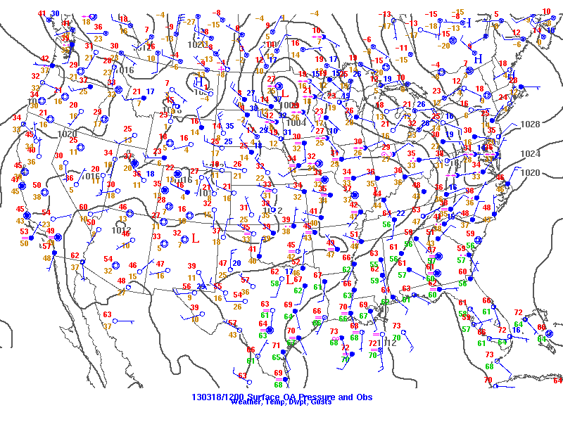
Surface analysis at 7 am Monday, March 18
|

Surface analysis at 7 pm Monday, March 18th
|
|
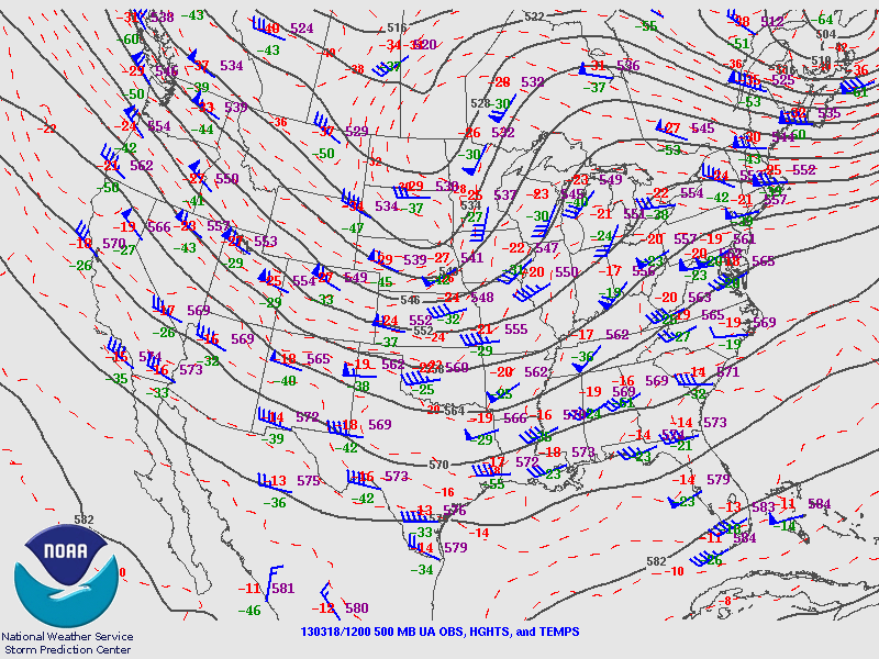
500mb analysis at 7 am Monday, March 18h
|

500mb analysis at 7 pm Monday, March 18th
|
|

BMX upper air sounding from 7 am March 18th
|
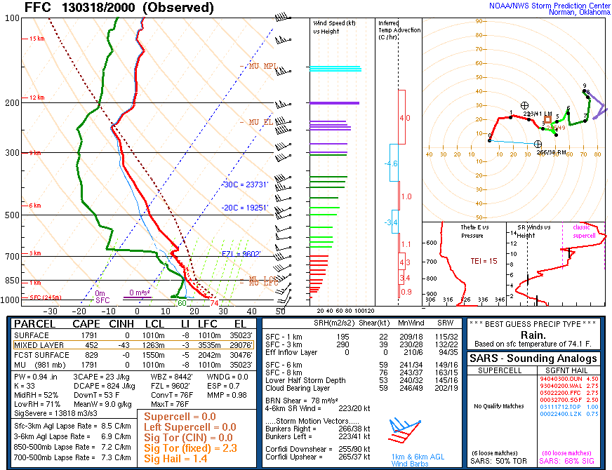
FFC upper air sounding from 3 pm March 18th
|
|
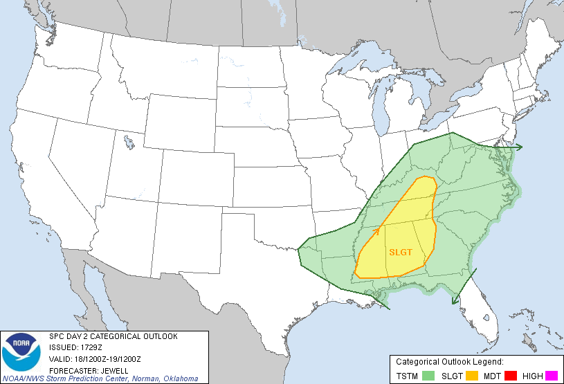
SPC Day 2 Outlook 1230 pm Sunday, March 17th
|
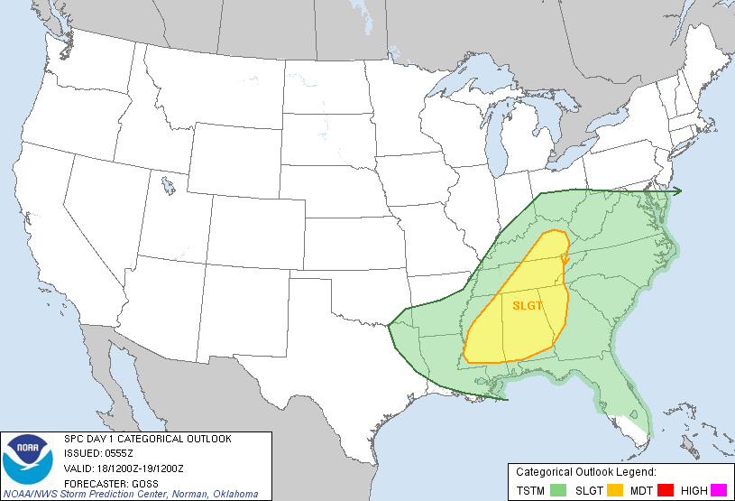
SPC Day 1 Outlook 7 am Monday, March 18th
|
|
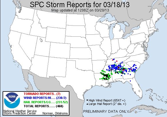
Storm Reports from event
|
|


 Follow us on YouTube