Severe Weather of April 25, 2003
Several supercell thunderstorms formed in the warm and unstable air mass that was in place across North and Central Alabama on the afternoon of Friday, April 25th. The focus of the thunderstorm activity was in a zone from Pickens and Sumter counties, east-southeastward across South Central Alabama, including the Selma and Montgomery areas, and on into Macon and Barbour counties. At least 4 long-lived supercell thunderstorms were identified and tracked, each containing significant rotation and radar signatures consistent with tornado formation.
All information should be considered preliminary, and subject to change, as long as surveys and verification are still being conducted.
Dancy (Pickens County) Tornado
After conducting a field survey near the Dancy community, in extreme southwest Pickens County, National Weather Service Meteorologists determined the damage was caused by a short-tracked weak tornado. The tornado briefly touched down just before noon, and was on the ground for roughly 100 yards, less than a minute. Despite the brief touchdown, it managed to lift a mobile home off its blocks and throw it several feet, and caused damage to another house near by.
The tornado did not hit any other substantial structures, and surrounding trees and other smaller objects in the area were virtually unharmed. The Fujita (F-scale) rating on this tornado is still being determined. Based on data from radar imagery and eyewitness accounts, this tornado may have been a type of twister known as a "landspout." The tornado seemed to form at the same time as the radar echoes showed up, before the developing cluster of thunderstorms consolidated into a supercell.
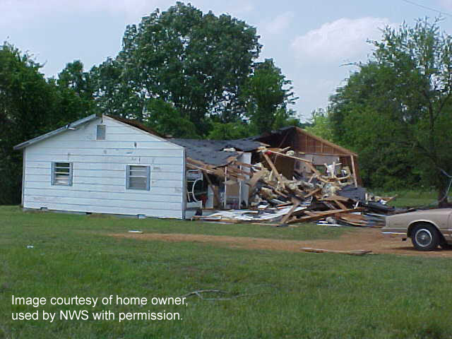
Damaged home near Dancy community, in southwestern Pickens County. 
Mobile home in same location that was lifted and thrown several feet. 
Map of location of damage. Click on each thumbnail for a larger view. Greene County Tornado
Based on eyewitness reports and information from Alabama Power Company, NWS Meteorologists investigated an area near the Greene County Steam Plant, on the Black Warrior River in the southern part of the county. There, they discovered tree damage from an apparent weak tornado. One of the trees fell on a mobile home, slicing it in half. One church in the area also had shingles lifted off its roof. Based on the fact that there was no significant damage caused directly by the tornado, this tornado was given an F0 rating on the Fujita scale.

A tree fell on this mobile home. 
Map of damage path for the Greene County Tornado. Click on thumbnail for a larger view. Prattville/Autauga County damage
The western side of Prattville in Autauga County was struck by what was believed to be straight line wind. The primary area affected ran from County Road 3 just south of US 82 to the river on Maple Street. This area is about 6 miles long and about 3 miles wide. Numerous trees in this path were downed, one fell on a mobile home and one fell on a house. Three minor injuries were reported where the tree fell on the house. Much of the damage and hail fell between 4:20 pm CDT and 4:35 PM CDT.
Hail also fell with this storm in a swath parallel and just north of the wind damage. Hail was reported to be golf ball size.
Elmore/Tallapoosa County damage
The only other area to receive a widespread area of damage was in northern and eastern Elmore and southern Tallapoosa Counties. Storm surveys revealed a swath of scattered damaged from the Titus community, southeastward to just north of Tallassee, and into Tallapoosa County near Martin Dam and Reeltown. There was no evidence of circulation or convergence, and this damaged was determined to have been caused by strong straight line winds.
Hail reports
The primary feature of most of the thunderstorms was large hail, at times as large as baseballs, and at times enough hail to cover the ground several inches deep. NWS Meteorologists found significant tree damage in several locations, where leaves and twigs had been stripped off, and there was a "carpet" of this debris, indicating a significant large hail storm.
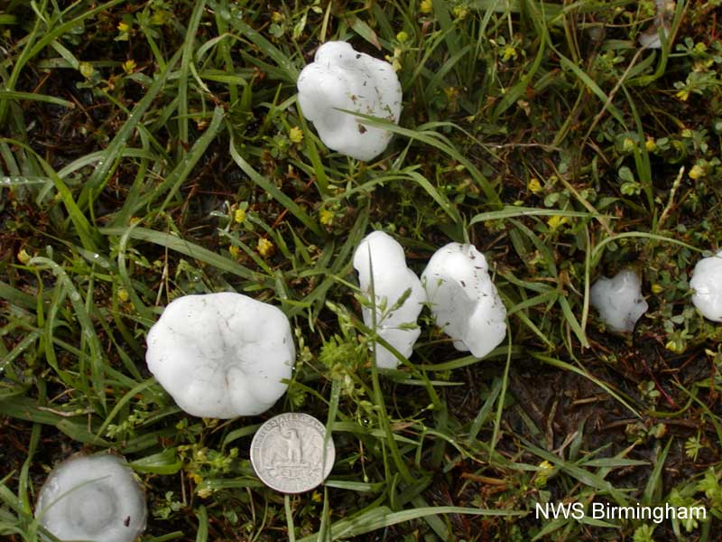
An example of the hail that fell in Dallas County near Valley Grande. 
Map of hail reports. 
Examples of the hail that fell in Montgomery County. Click on each thumbnail for a larger view. Other damage
There were several other, less widespread locations with wind damage, mainly to trees and power lines. These included near Maplesville and Clanton (both in Chilton County), Prattville (Autauga County), Gadsden (Etowah County), and Dixons Mill (Marengo County). Storm spotters also reported several funnel clouds, which apparently never touched down or did any damage.


 Follow us on YouTube