|
Event Summary for Central Alabama
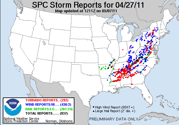
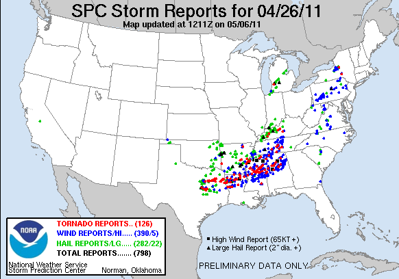
As part of a system which wreaked havoc across the eastern half of the United States (April 25-28), the following is an account of the tornado outbreak of April 27th, 2011, in Central Alabama.
National Weather Service meteorologists completed the assessment of storm damage from this tragically historic day of tornadic activity and severe weather across Central Alabama on Wednesday, April 27th. Nationally recognized storm damage experts assisted us in examining the locations of the most extreme damage to ensure we provided the most accurate assessment of this event as possible.
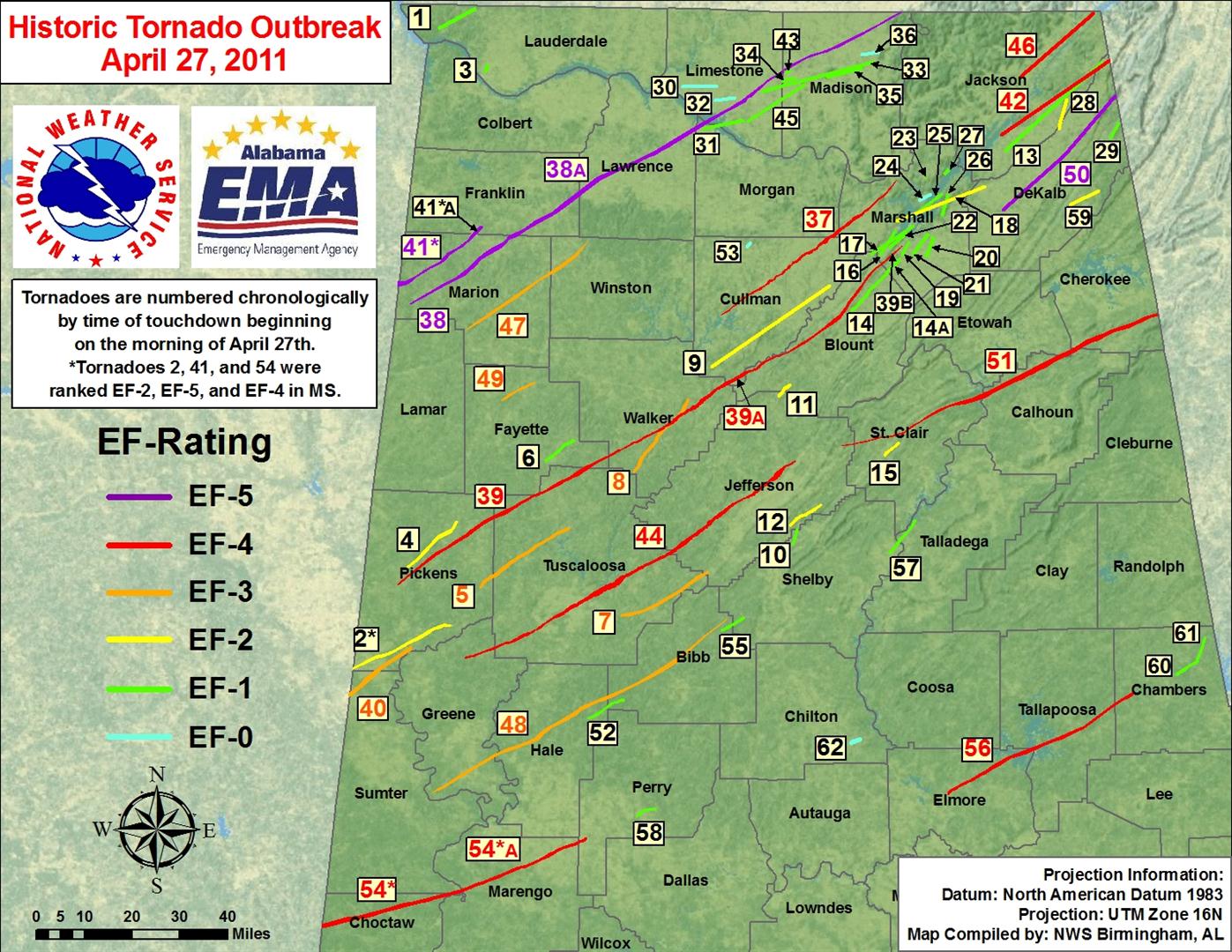
In total, there were 29 confirmed tornadoes in Central Alabama on this day, and 62 confirmed tornadoes across the State of Alabama.
Click on the numbered boxes on the map below to view more detailed information about each tornado track.
|
 |
|
The tornado damage swaths as depicted in the image above, and on the individual tornado links, are an estimate of the damage widths along the track. In other words, the track width may not represent the actual damage in all locations, as we interpolate the values between actual surveyed damage points. These maps are soley for the purpose of showing the general track of each tornado. Remember, tornadoes do not always move in straight lines, and the intensity does not remain constant. It is also possible to have other thunderstorm wind-related damage in close proximity to the tornado tracks from such features as inflow and rear flank downdrafts, which can produce tornado-like damage. For a satellite image of the tornado tracks, click here.
For comprehensive GIS information, including ESRI Shapefiles and Google Earth KMZ files of tornado paths, storm survey points, and tracks of all 62 tornadoes, click on the link below:
Pertinent Geographic Information Systems (GIS) Data from the April 27th, 2011 Outbreak
Important Note: The Shapefiles and KMLs are experimental data.
To tell the story of April 27, 2011, one has to recognize that there were two distinct waves of widespread severe weather in Central Alabama. The first wave of severe storms moved through during the early morning hours across northern portions of Central Alabama in the form of a Quasi-Linear Covective System (QLCS). This intense line of thunderstorms produced not only widespread damaging straight line winds in the areas of Moody, Pell City and Riverside, but numerous strong tornadoes. The table below is an account of the tornadoes caused by the QLCS:
|
|
Location/Clickable Detailed Summary Link
|
Damage Rating/Estimated Maximum Wind Speeds
|
Injuries/Fatalities
|
Damage Path Length/Width
|
Starting Point/Time
|
Ending Point/Time
|
|
|
|
None
|
22.63 miles /
1056 yards
|
32.9921/-88.3403
416 am
|
33.1275/-87.9844
435 am
|
|
|
EF-2
120 mph
|
None
|
14.36 miles /
1232 yards
|
33.3007/-88.1496
427 am
|
33.4445/-87.9699
442 am
|
Holman (Pickens and Tuscaloosa Counties)
|
EF-3
140 mph
|
None
|
22.46 miles /
704 yards
|
33.2448/-87.8817
441 am
|
33.4268/-87.5605
502 am
|
|
|
EF-1
100 mph
|
4 Injuries
|
7.28 miles /
176 yards
|
|
33.6943/-87.5462
511 am
|
Coaling (Tuscaloosa and Jefferson Counties)
|
EF-3
155 mph
|
None
|
20.26 miles /
200 yards
|
33.1630/-87.3716
517 am
|
33.2960/-87.0594
535 am
|
|
|
EF-3
140 mph
|
20 Injuries
|
18.90 miles /
375 yards
|
33.5979/-87.3278
518 am
|
33.8176/-87.1320
536 am
|
Altadena (Shelby and Jefferson Counties)
|
EF-1
100 mph
|
None
|
3.39 miles /
100 yards
|
33.3780/-86.7509
550 am
|
33.4255/-86.7362
554 am
|
|
|
EF-2
135 mph
|
3 Injuries
|
3.23 miles /
200 yards
|
33.8300/-86.8012
553 am
|
33.8627/-86.7610
557 am
|
|
|
EF-2
120 mph
|
20 Injuries
|
7.76 miles /
200 yards
|
33.4367/-86.7622
554 am
|
33.4980/-86.6493 600 am
|
|
|
|
None
|
10.68 miles /
200 yards
|
34.0894/-86.5342
612 am
|
34.2021/-86.4063
622 am
|
|
|
EF-2
120 mph
|
5 Injuries
|
3.84 miles /
200 yards
|
33.6473/-86.4153
616 am
|
33.6848/-86.3661
619 am
|
|
|
The second wave, which began with the Hackleburg EF-5 tornado, involved numerous supercell thunderstorms which produced deadly long-lived, strong to violent tornadoes across the northern two-thirds of Central Alabama. Widespread and catastrophic damage was sustained in several locations. The table below is an account of the tornado activity from the afternoon hours on the 27th:
|
|
Location/Clickable Detailed Summary Link
|
Damage Rating/Estimated Maximum Wind Speeds
|
Injuries/Fatalities
|
Damage Path Length/Width
|
Starting Point/Time
|
Ending Point/Time
|
|
|
|
100 Injuries /
18 Fatalities
|
25.14 miles /
3/4 mile
|
34.1043/-88.1479
305 pm
|
34.3109/-87.7858
328 pm
|
Cordova (Pickens, Tuscaloosa, Fayette, Walker and Blount Counties)
|
|
54 Injuries /
13 Fatalities
|
116.45 miles /
1408 yards
|
33.2506/-88.1814
340 pm
|
34.2275/-86.4270
550 pm
|
Panola (Sumter and Pickens Counties)
|
|
2 Injuries
|
16.24 miles /
1056 yards
|
32.9149/-88.3495
357 pm
|
33.0604/-88.1299
415 pm
|
|
|
|
100 Injuries /
7 Fatalities
|
18.48 miles /
3/4 mile
|
34.1677/-88.1932
400 pm
|
34.3128/-87.9215 420 pm
|
|
|
EF-4
190 mph
|
1500 Injuries /
65 Fatalities
|
80.68 miles /
2600 yards
|
33.0297/-87.9350
443 pm
|
33.6311/-86.7436
614 pm
|
|
|
EF-3
150 mph
|
25 Injuries
|
31.84 miles /
1320 yards
|
34.0289/-87.9421
510 pm
|
34.3039/-87.4968 547 pm
|
|
|
EF-3
145 mph
|
50 Injuries /
7 Fatalities
|
|
32.6152/-88.0543
530 pm |
33.1524/-86.9898
655 pm
|
|
|
EF-3
145 mph
|
None
|
7.96 miles /
0.5 mile
|
33.8129/-87.8108
606 pm
|
33.8683/-87.6892
614 pm
|
|
|
|
81 Injuries /
22 Fatalities
|
71.30 miles /
1760 yards
|
33.6792/-86.5699
628 pm
|
34.0664/-85.4190
745 pm
|
|
|
EF-1
110 mph
|
None
|
8.62 miles /
300 yards
|
32.8478/-87.4922
650 pm
|
32.9047/-87.3605
702 pm
|
Marvel (Bibb and Shelby Counties)
|
EF-1
105 mph
|
None
|
5.41 miles /
50 yards
|
33.1169/-87.0081
732 pm
|
33.1560/-86.9274
738 pm
|
|
|
|
3 Injuries
|
32.81 miles /
350 yards
|
32.3077/-88.0159
747 pm
|
32.4829/-87.4942
835 pm
|
|
|
EF-4
170 mph
|
30 Injuries /
7 Fatalities
|
44.18 miles /
880 yards
|
32.6174/-86.1930
812 pm
|
32.9196/-85.5230
909 pm
|
|
|
EF-1
105 mph
|
None
|
8.59 miles /
200 yards
|
33.3507/-86.4013
815 pm
|
33.4483/-86.3092
824 pm
|
|
|
EF-1
90 mph
|
None
|
4.24 miles /
100 yards
|
32.5519/-87.3142
850 pm
|
32.5748/-87.2466
853 pm
|
|
|
EF-1
110 mph
|
None
|
5.24 miles /
150 yards
|
32.9719/-85.3688
919 pm
|
33.0114/-85.2916
928 pm
|
|
|
EF-1
90 mph
|
None
|
5.01 miles /
100 yards
|
33.0158/-85.2938
929 pm
|
33.0836/-85.2633
938 pm
|
|
|
EF-0
80 mph
|
1 Injury
|
1.91 miles /
50 yards
|
32.7759/-86.5429
948 pm
|
32.7857/-86.5122
950 pm
|
|
|
Central Alabama April 27th Statistics
|
| |
| - April 27th was one of the largest super-tornado outbreaks in Central Alabama history. |
| - April 25th-28th was one of the largest super-tornado outbreaks in US history. |
| - There were 29 confirmed tornadoes in Central Alabama on April 27th. 62 tornadoes occurred across the state. |
| - The combined tornado damage path length in Central Alabama was 691.02 miles. |
| - Sixteen of the tornadoes had damage path lengths over 10 miles long. |
| - Eight of the tornadoes had damage path lengths over 25 miles long. |
| - Eight tornadoes either started or ended outside Central Alabama. |
| - There were at least 1998 injuries reported and 240 people lost their lives. |
| - Tornado Watch 225 was in effect from 226 am CDT until 8 am CDT. |
| - Tornado Watch 230 was in effect from 812 am CDT until 2 pm CDT. |
| - PDS Tornado Watch 235 was in effect from 145 pm CDT until 10 pm CDT. |
| - PDS Tornado Watch 241 was in effect from 552 pm CDT until 1 am CDT. |
| - Tornado Watch 245 was in effect from 942 pm CDT until 2 am CDT. |
| - NWS BMX issued 49 Tornado Warnings. |
| - NWS BMX issued 24 Severe Thunderstorm Warnings. |
| |
|
Number of Tornadoes by EF-Scale
|
| EF0 |
EF1 |
EF2 |
EF3 |
EF4 |
EF5 |
| 1 |
10 |
5 |
8 |
4 |
1 |
| |
| Other Storm Reports & Storm Surveys from this Historic Event |
- NOAA Aerial Imagery
- NOAA April 2011 Tornadoes
- NSSL April 27th Tornado Tracks
- NOAA Climate Services Investigates April 2011 Tornadoes
- NOAA releases aerial imagery of Tuscaloosa, Al. tornado damage
- SPC Severe Weather Events Archive
- NWS Jackson, MS.
- NWS Memphis, TN.
- NWS Paducah, KY.
- NWS Tallahassee, FL.
- NWS Columbia, SC.
- NWS Atlanta, GA.
- NWS Mobile, AL.
- NWS Shreveport, LA.
- NWS Huntsville, AL.
- NWS Nashville, TN.
- NWS Morristown, TN.
- NWS Louisville, KY.
- NWS Wakefield, VA.
- NWS San Angelo, TX.
|
|
Severe Weather Episode Data
|
|
|
| |
|
|


 Follow us on YouTube