Severe Weather & Flooding of May 7, 2003
During the morning of May 7, a supercell thunderstorm moved out of Mississippi and across northwest Alabama. When that thunderstorm reached central Alabama in the afternoon, additional severe supercell thunderstorms began to develop. Before all was said and done, the storms would go on to produce several tornadoes, scattered areas of wind damage, some hail, and an incredible amount of rain. The main area affected stretched eastward from Lamar County, to the northern areas of Metro Birmingham, and farther east along and south of Interstate 20.
All information should be considered preliminary, and subject to change, as long as surveys and verification are still being conducted. Additional images will be added as they become available.
A brief F1 tornado touched down in the central part of Lamar County, about 3 miles north of Vernon, just east of State Highway 17. Damage was mostly to trees and power lines.

|

|
|
|
|
||
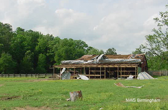
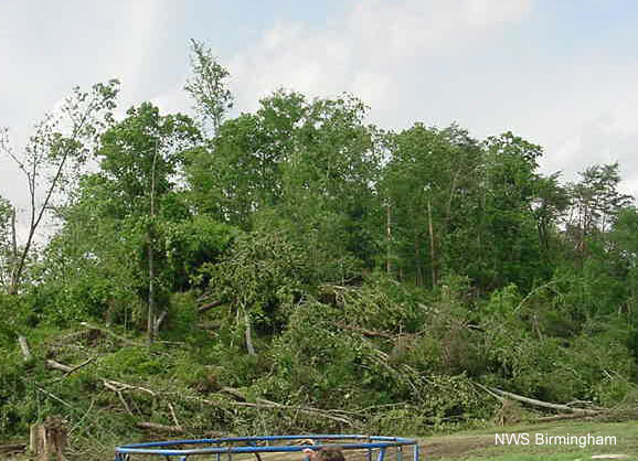
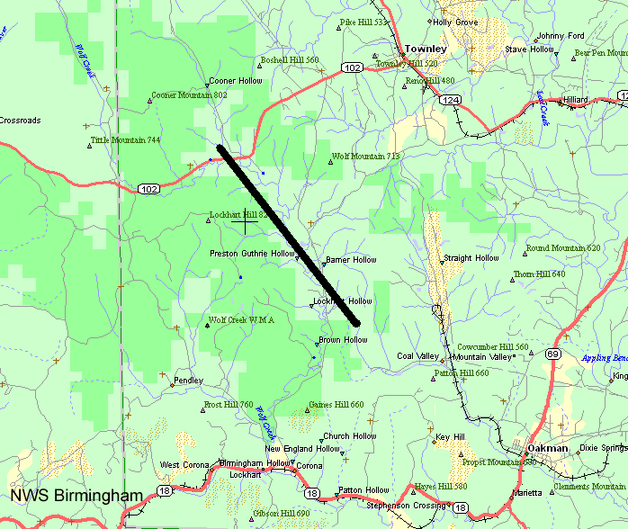
The same storm that produced the damage in Lamar dropped its second F1 tornado of the day in a highly wooded area of southwestern Walker County, northwest of Oakman. At least one barn was damaged, in addition to numerous trees.
|
|
|
|
|
||
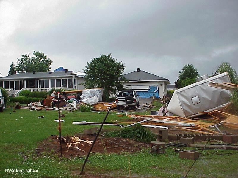
The first of two tornadoes to touch down in southern Saint Clair County began around 210 pm, northwest of Pell City near the intersection of Highway 174 and Cook Springs Road. From there, the tornado travelled southeast through the Bowman Circle and Stewarts areas and lifted near Interstate 20, between exits 156 and 158. It downed many trees and powerlines, and also damaged a few buildings in the area. This tornado has been rated an F1 on the Fujita scale.

|
|
|
Around 240 pm, an F1 tornado cut a 4.5 mile long swath of damage, just south of the city of Munford, in northern Talladega County.

|
|
|
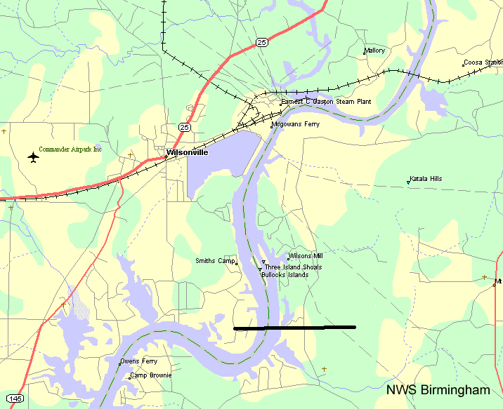
While the long lived storms continued near and east of Birmingham, a developing supercell quickly gained strength in Shelby County. This storm produced its first tornado around 245 pm. It touched down just southeast of Wilsonville, where it damaged some boat houses and other structures. It then moved east across the Coosa River, into southern Talladega County, where it damaged several trees before lifting. Due to the damage inflicted on the boat houses on the Shelby County side of the river, this tornado has been rated an F1.
|

|
|
|
|
||
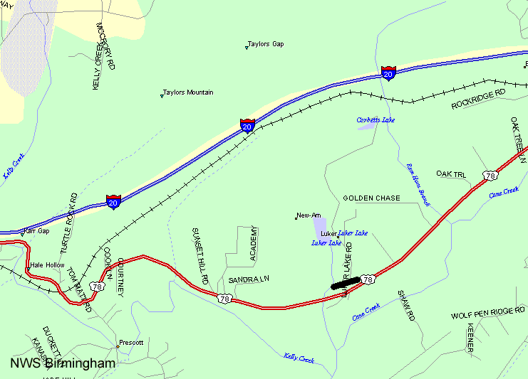
An F0 tornado briefly touched down around 321 pm in western Saint Clair County, on Luker Lake Road, near Highway 78 between the Prescott and Cook Springs communities.
|
|
|
A series of three weak, F0, tornadoes touched down in Clay County, causing mostly damage to trees. The first touchdown was in the Bull Gap area in the southwestern part of the county, just north of Highway 148. The second tornado touched down just south of Ashland, and caused some light damage to a manufacturing plant. The third tornado skirted the southern and eastern sections of Lineville, causing mainly scattered tree damage.

|
|
|
The final, and longest lived, tornado of the day touched around 440 pm down just south of the city of Wedowee, causing damage to several businesses near the intersection of Highway 431 and County Road 15. From there, the tornado moved east-northeast for at least 12 miles, through the Rocky Branch and Napoleon communities, and all the way to the Georgia State Line. This tornado was rated an F1 on the Fujita scale. Aside from the businesses near the initial touch down location, the tornado travelled across mainly wooded areas, with only a few other structures being hit.

|

|

|
|
|
||
There were numerous loactions of tree damage, and light damage to buildings, across the state.
Besides the tornadoes, the main feature associated with the thunderstorms on May 7 was the amount rain they produced, and the subsequent flooding that resulted. The tropical air mass that gave fuel to the thunderstorms provided an enormous amount of moisture, and the storms were able to efficiently produce an incredible amount of rain.
The north and northeast sections of Metro Birmingham were hit especially hard, as several waves of thunderstorms dumped as much as 11 inches of rain on the area in only a few hours. This caused historic flooding in much of northeast Birmingham and the suburbs. Flooding was reported across the whole width of of Alabama, from where the storms entered Lamar County in the west, to where they exited in Cleburne and Randolph Counties in the east.
All of that water flowed from creeks and streams into the larger rivers, causing even more flooding. The city of Wadley, in southwestern Randolph County, became nearly isolated by the flooded Tallapoosa River. As the river there rose to record levels, the Highway 22 bridge that connects Wadley to other cities and towns to the east became completely submerged. Other cities and towns near many of Alabama's major rivers reported similar flooding. Even areas that did not experience that much rainfall were threatened by flooding, as all the water carried downstream.


 Follow us on YouTube