|
Tornadoes and Wind Damage on August 6, 2015
|
|
During the afternoon and evening of August 6th, highly unusual conditions came together to create an environment favorable for severe thunderstorms including rare August supercells and tornadoes. A relatively sharp 500mb trough over the Ohio and Tennessee Valley regions moved southeastward and provided a focus for thunderstorm development. Well-developed 850mb and 700mb cyclones were associated with sufficient speed and directional shear across Alabama for sustained supercell structures. More remarkably, the presence of strongly veering surface to 850mb winds and 0-1km helicity around 250 m2/s2, created an environment favorable for short-lived tornadoes. Aside from tropical systems that have produced tornadoes in the Gulf Coast states in August, the two tornadic supercells associated with the mid-latitude cyclone on August 6th, may be the first of their kind documented in the Birmingham County Warning Area.
|
|
|
EF-1
|
|
Estimated Maximum Wind:
|
100 mph
|
|
Injuries/Fatalities:
|
7 Injuries |
|
Damage Path Length:
|
0.40 miles
|
|
Maximum Path Width:
|
50 yards
|
|
Approximate Start Point/Time:
|
31.7817/-85.9403 at 1035 pm
|
|
Approximate End Point/Time:
|
31.7765./-85.9377 at 1036 pm
|
|
|
National Weather Service meteorologists surveyed the damage in Troy and have determined that the damage was the result of an EF-1 Tornado. The tornado touched down just south of the Pike Liberal Arts School behind the Troy Walmart. Damage to the Walmart extended from the rear of the building to the front, with a portion of the roof collapsed. The damage was confined to a very narrow path, with other HVAC systems a few yards either side of the main damage area largely intact. Significant damage was caused to the entrances of the store as well. As the tornado crossed the parking lot, it pushed an empty tractor-trailer approximately 100 yards into a second tractor trailer, damaging both. A third tractor trailer was overturned, causing major damage. The tornado then clipped the south end of a strip mall, collapsing the front glass walls and a portion of a masonry wall on the side of Hibbett Sporting Goods. Minor damage was caused to the canopy of the Murphy USA gas station across the parking lot. The tornado crossed U.S. Highway 231 and weakened rapidly, with only minor damage caused to a convenience store across the highway before dissipating.
|
|
|
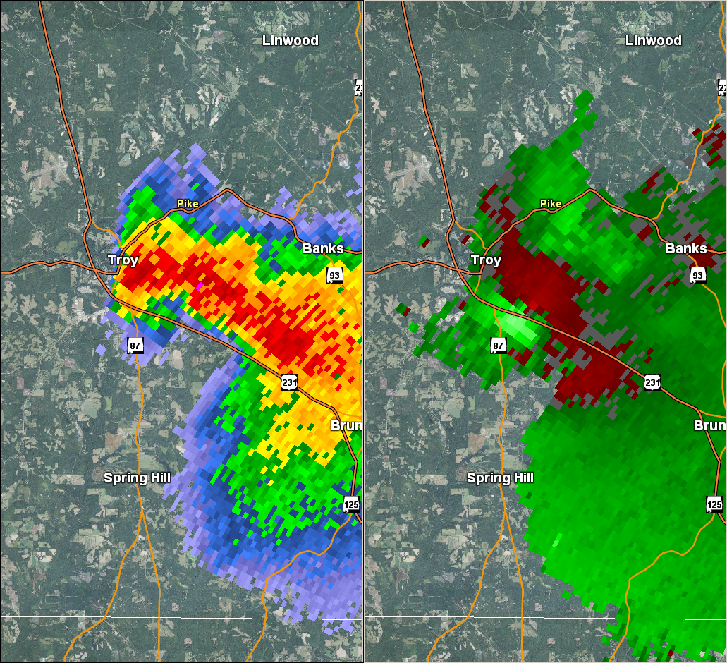
This is an image of the 0.5 degree reflectivity (left) and velocity (right) data from KEOX Radar at 1034 pm.
Click to enlarge.
|
|
Storm Damage Images - Click to Enlarge
|
|

Damage to Hibbett Sporting Goods
|

Damage to Hibbett Sporting Goods
|
|

Walmart Roof Damage
|

Walmart Damage
|
|
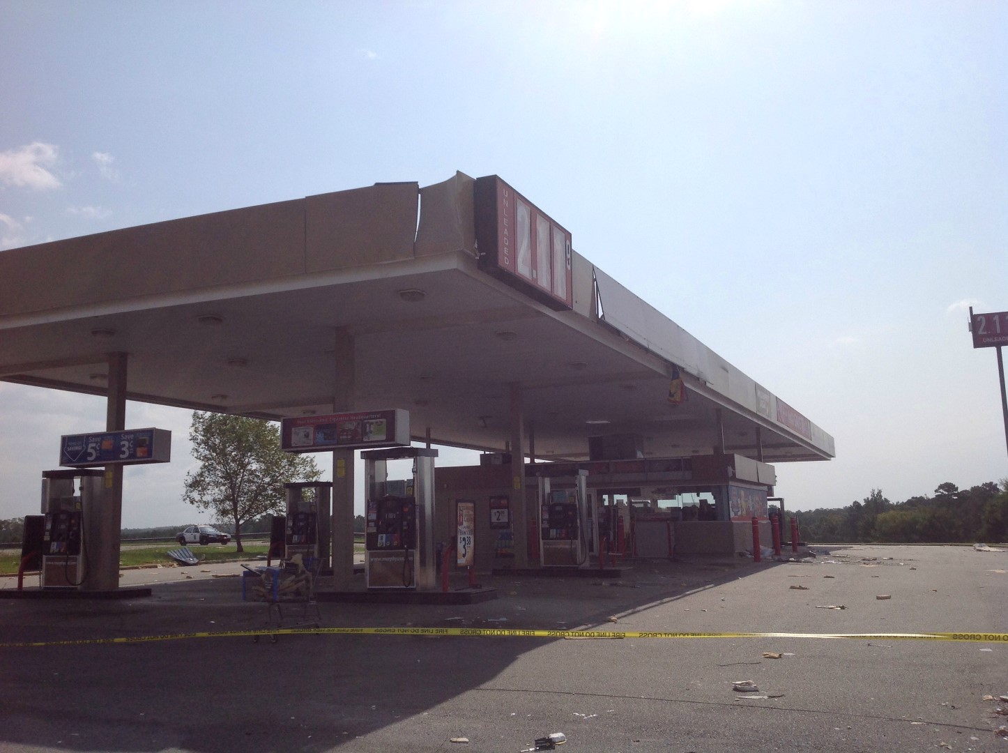
Murphy USA Damage
|

Debris Tossed across Walmart Parking Lot
|
|
|
EF-0
|
|
Estimated Maximum Wind:
|
70 mph
|
|
Injuries/Fatalities:
|
None |
|
Damage Path Length:
|
1.99 miles
|
|
Maximum Path Width:
|
250 yards
|
|
Approximate Start Point/Time:
|
32.3139/-85.0847 at 840 pm
|
|
Approximate End Point/Time:
|
32.3369/-85.0661 at 844 pm
|
|
|
National Weather Service meteorologists surveyed damage in eastern Russell County and confirmed that a weak tornado touched down just north of the Avalon Church on Tarver Road near Seale and tracked northeastward through the Avalon Community, causing sporadic tree damage and damage to outbuildings and unsecured objects. It continued northeastward, crossing Pine Haven Street where sporadic tree damage continued with at least one tree blown down across the road. The tornado continued across the road for a short distance and quickly dissipated.
|
|
This is an image of the 0.5 degree reflectivity (left) and velocity (right) data from KMXX Radar at 1034 pm.
Click to enlarge.
|
|
|
N/A |
|
Estimated Maximum Wind:
|
90 mph
|
|
Injuries/Fatalities:
|
None |
|
Damage Path Length:
|
0.06 miles
|
|
Maximum Path Width:
|
150 yards
|
|
Approximate Start Point/Time:
|
32.3256/-85.0076 at 851 pm
|
|
Approximate End Point/Time:
|
32.3261/-85.0071 at 851 pm
|
|
|
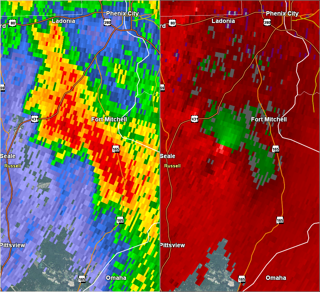
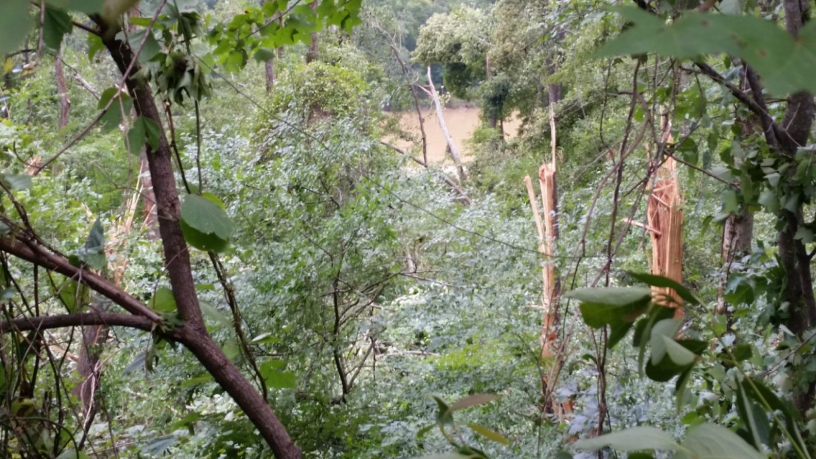
An apparent microburst associated with a rear inflow notch on a bowing line segment caused an area of widespread and significant tree damage along and just east of 101st Airborne Division Road just east of Alabama Highway 165. A single tree fell across AL-165 about 300 yards south of the intersection with 101st Airborne Division Road, which caused an accident when a motorist ran into it. However, the main impact of the microburst was along and east of 101st Airborne Division Road approximately .75 miles north of Dixie Road. A densely forested area of hardwood trees approximately 150 yards wide by 100 yards deep were either snapped or uprooted by winds of up to 90 mph between the road and the Chattahoochee River in a slightly fanned pattern pointing to the northeast. The damage area did not appear to make it all the way to the river.
|
|

This is an image of the 0.5 degree reflectivity (left) and velocity (right) data from KMXX Radar at 851 pm.
Click to enlarge.
|
|
Storm Damage Images - Click to Enlarge
|
|
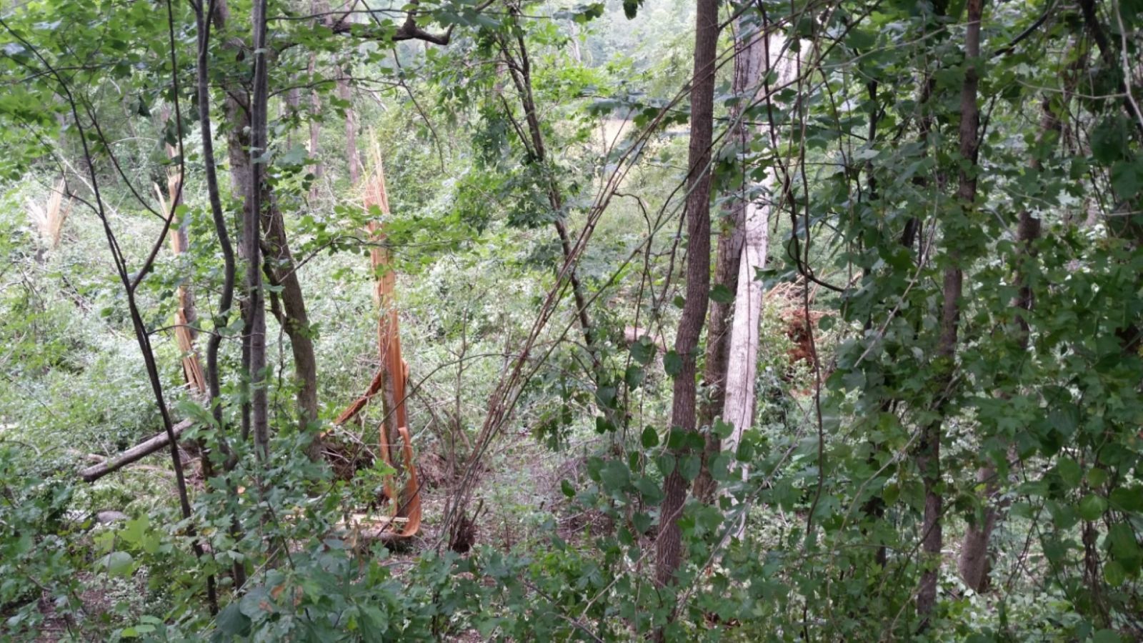
Tree Damage
|
Tree Damage
|
|


 Follow us on YouTube