National Weather Service United States Department of Commerce

Heavy Rainfall, Tornadoes, Wind, & Snow
December 9 - December 11, 2008


Event Summary for Central Alabama


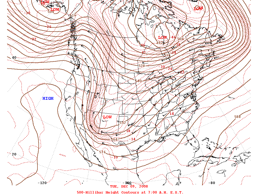
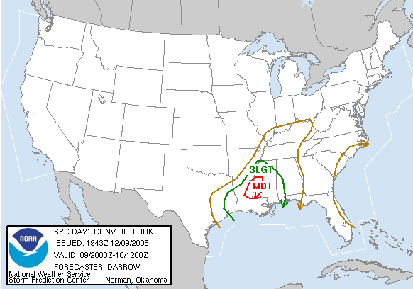
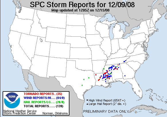
A vigorous upper level low, a cold front, and a warm front all contibuted to hazardous weather development generally from late on December 9th through December 11th. Thunderstorms developed in the warm sector late Friday evening. This warm sector was rather unstable for December with Lifted Indices -2 to -3 and CAPE values up to 1000. As the storms traveled northeastward, they encountered a warm front. Three tornadoes touched down as the storms interacted with the front. Additional wind damage reports were received as the cold front and associated storms slowly moved eastward into Central Alabama early Saturday morning. Tornado Watches were in effect for portions of Central Alabama between 800 pm and 800 am December 9th into December 10th.

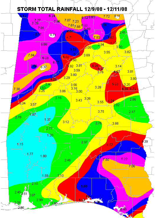
Atmospheric moisture values were tremendous as precipitable water values were a few standard deviations above normal for December. Heavy rain developed near the cold front as energy from the upper low was ejected northeastward. Most locations received 2 to 5 inches of rainfall from the 9th through the 11th. Areas in the far northwest received maximum values of up to 8 inches. This rainfall produced some flash flooding as well as some river flooding.

As the deepening upper low moved over Central Alabama, dynamic coooling was responsible for a changeover to snow in northwest areas. Parts of Marion, Lamar, Fayette, and Winston Counties experienced some snow. The measurable snow ranged from about 1 to 3 inches with a few areas possibly a tad higher.


Identified Damage Areas;

EF-1 Oakman Tornado - Walker County

EF-2 Sipsey Tornado - Walker County

EF-1 Moody Tornado - St. Clair County

Alabama Rainfall Totals

Preliminary Local Storm Reports Dec 10th

Preliminary Local Storm Reports Dec 11th

Tornadoes in Central Alabama with this Event:
(Click for EF Scale)
3
Total Fatalities:
0
Total Injuries:
0


National Weather Service - Huntsville, AL Assessments...Storm Survey

National Weather Service - Jackson, MS Assessments...Severe | Winter 


Weather Episode Data


Surface Analysis 12/9 6 am
Surface Analysis
December 9th 6 am
500 mb Chart 12/9 6 am
500 mb Chart
December 9th 6 am
Surface Analysis 12/10 6 am
Surface Analysis
December 10th 6 am
500 mb Chart 12/10 6 am
500 mb Chart
December 10th 6 am
Surface Analysis 12/11 6 am
Surface Analysis
December 11th 6 am
500 mb Chart 12/11 6 am
500 mb Chart
December 11th 6 am
Day 3 Severe Weather Outlook
Issued December 7th
Day 3 Severe Weather Probabilistic
Day 3 Probabilistic Outlook
Issued December 7th
Day 2 Severe Weather Outlook
Issued December 8th
Day 2 Severe Weather Probabilistic
Day 2 Probabilistic Outlook
Issued December 8th
Day 1 Severe Weather Outlook
Issued December 9th
Day 1 Severe Weather Probabilistic
Day 1 Probabilistic Outlook
Issued December 9th
Severe Weather Reports
Preliminary Severe Weather Reports
December 9th - December 10th
Estimated Rain
Estimated Rainfall
December 9th - through December 11th