National Weather Service United States Department of Commerce

Coxey Rogersville Anderson Cartwright Fort Payne Branchville Russellville Bay Hill Marina Williams Creek Hazel Green/Charity Ln Lowndes EF-1 (MS) Melborne Lowndes EF-2 (MS) Ethelsville Bazemore Shiloh/Higdon Welti/Berlin Boldo Siloam Little Sandy Creek Kimberly Graysville Abernant North Johns Bessemer Airport Road Clarke Co EF-1 Highland Lake Owens Creek Aroney Dawson Ft Payne/Pine Ridge Sardis City Aroney#2 Mentone Pumpkin Center Society Hill Crawford/Salem Geneva EF-1 Perote Alexander City Mines Road Murphree Place Bethel-Wolf Springs Scottsboro-Rosalie Madison Poplar Springs Shottsville Henson Springs Tuscumbia-Muscle Shoals Polecat Creek Chatom-Grove Hill Georgiana Shellhorn#1 Shellhorn#2 Firetower Rd Forkland Cowikee Creek Cowikee Creek FFC

Pertinent Geographic Information Systems (GIS) Data
of 2014 Tornadoes throughout the State of Alabama

NWS Birmingham GIS Data Page  2014 State of Alabama Tornado Statistics  Alabama Tornado Database


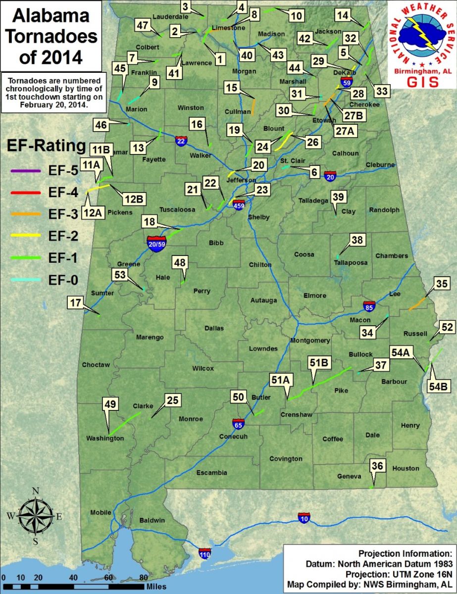
The National Weather Service in Birmingham is offering GIS data from storm surveys following severe weather events.  These data offer survey information from tornado tracks that are found by damage assessment teams in the field.  The links below contain information for 54 tornadoes that have been surveyed across the State of Alabama that occurred during the entire calendar year of 2014Most information was produced and extracted from the National Weather Service Damage Assessment Toolkit, which has been developed by National Weather Service Meteorologists to modernize storm survey information into a geospatial format for the general public and GIS analysts.  The information can be passed along to decision makers and the emergency management community after storm surveys have been completed.

ESRI Shapefiles:       

Select Tornado Swaths - (Updated 1/4/2015) Zipped folder contains polygon shapefiles of individual tornado tracks and estimated damage swaths, as well as an all inclusive shapefile that has all path information merged together.  Shapefile projections are in Universal Transverse Mercator Zone 16N.

Select Survey Points(Updated 1/4/2015) Zipped folder contains point shapefile locations within specific tornado paths that include detailed survey information gathered from assessment teams in the field.  The attribute information includes:  Event Date, Survey Date, Damage Indicator, Degree of Damage, EF-Rating at the point location, Wind Speed, and the Tornado associated with the survey point. Shapefile projections are in Universal Transverse Mercator Zone 16N.

All Tornado Paths - (Updated 1/4/2015) Zipped folder contains line shapefiles of all 54 tornado tracks across the State of Alabama for 2014.  Attribute information includes:  Tornado Name, EF-Scale, Peak Wind, Counties affected, Start Time, Beginning and Ending Latitudes and Longitudes, End Time, Maximum width in miles and yards, Order Number of the tornado segement, and Tornado Number according to the statewide tornado map.  Shapefile projections are in Universal Transverse Mercator Zone 16N.

Attention GIS Analysts Using ArcGISPlease view the metadata within ArcCatalog to view a complete description of shapefile information.
 

 Google Earth KMZ Files:     

Tornado Survey Information KMZ (Updated 1/4/2015) Google Earth KMZ contains all the detailed storm survey information gathered for the 54 tornadoes in the State of Alabama.  In select locations, damage photographs taken by assessment teams can also be viewed.  Be advised that this information is still deemed as experimentalMost information was extracted from the National Weather Service Damage Assessment Toolkit.
 

Statewide Map - Tornadoes of 2014:

Using post-event storm survey information from the National Weather Service in Huntsville, National Weather Service in Mobile,National Weather Service in Tallahassee, National Weather Service in Jackson, MS, and National Weather Service in Peachtree City, GA, a detailed statewide tornado map has been created.  The map below depicts the tornado tracks starting on February 20th and ending on November 23rd.  Each number below represents the start time of each tornado in chronological order, beginning on February 20th.

54 tornadoes have been confirmed across the entire state.  By clicking on the numbers below, you will be taken to detailed survey information regarding the tornado of interest.

 *Tornadoes with A and B notations were crossover tornadoes from multiple NWS offices.
 
Interactive Map - Tornado Paths and Survey Points:


The map below presents an interactive view of tornado paths and survey locations collected by damage assessment teams in the field throughout the entire 2014 year throughout the State of Alabama. These data can be downloaded using the links for the Paths, Points, and Swath shapefiles above. To view information from the survey points, zoom in to the specific point of interest and click on the point. A pop-up box will appear with specific survey information. Damage photographs, if they are available, can be viewed by clicking on the "Damage Photograph" link at the top of the pop-up box. If several features appear within a close proximity to one another, look for the "Next Feature" button (>) on the top right of the pop-up to view each feature. To zoom in and out, use your mouse wheel or use the plus and minus buttons in the top left corner of the map. Once again, these data are experimental.
 

View Larger Map