| Information the Radar Can Show Us |
Reflectivity
These images are just as they sound as they paint a picture of the weather from the energy reflected back to the radar. There are two types available on the web; Base (or 0.5 degree elevation) reflectivity and Composite reflectivity.
Base Reflectivity is the default image. Taken from the lowest (0.5 degree elevation) slice, it is the primary image used to "see what's out there". There are two versions of Base Reflectivity image; the short range version which extends out to 124 nm (about 143 miles) and the long range version which extends out to 248 nm (about 286 miles). This image is available upon completion of the 0.5 degree elevation scan during each volume scan.
For a current Base Reflectivity image, click here.
|
 |
|
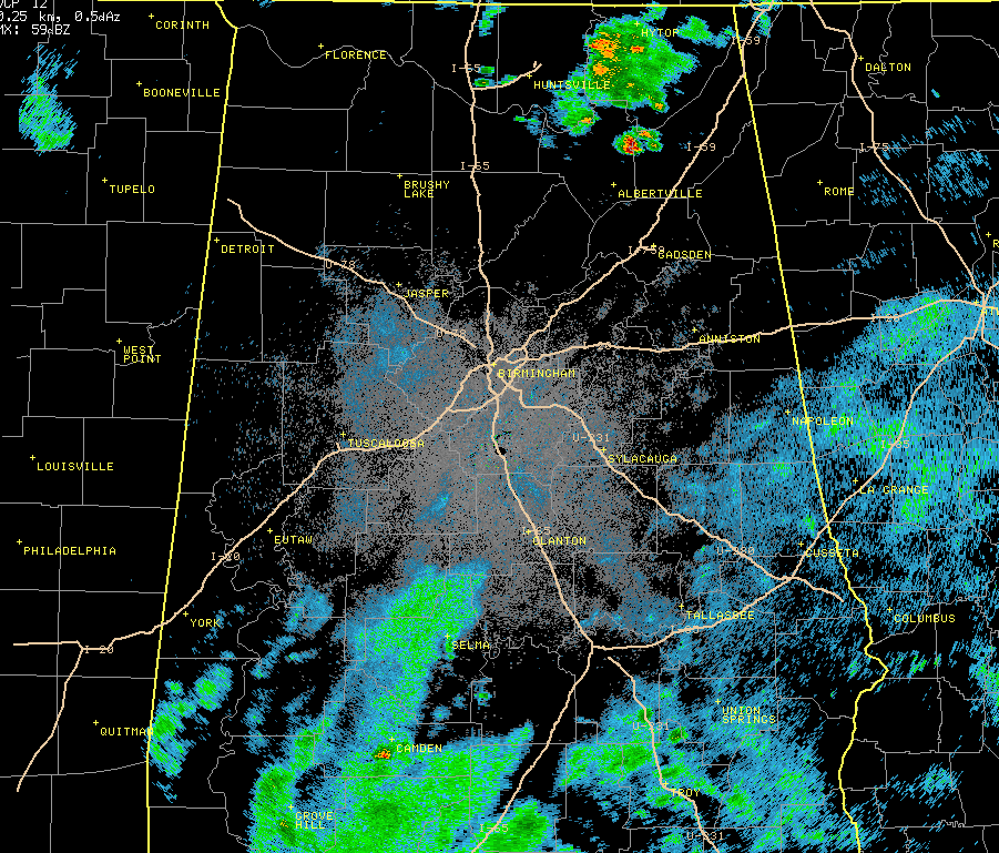
This is a base reflectivity image centered over BMX. Notice as you get further away from the radar, the reflectivity has a "rounded" look to it
|
|
|
Composite Reflectivity images utilize all elevation scans during each volume scan to create the image. It is composed of the greatest echo intensity (reflectivity) from any elevation angle seen from the radar. It is used to reveal the highest reflectivity in all echoes.
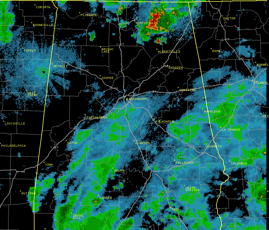
The images on the right were captured at the same time with each type of reflectivity to illustrate the difference. They may look almost the same, but notice the difference in reflectivity values over northeast Alabama.
For a current Composite Reflectivity image, click here.
|
 |
|
This is a composite reflectivity image
centered over BMX.
|
|
|
Velocity
One of the best features on the 88D Doppler radar is its ability to detect motion. However, the only motion it can "see" is either directly toward or away from the radar. This is called radial velocity as it is the component of the target's motion that is along the direction of the radar beam.
In all velocity images, red colors indicate wind moving away from the radar with green colors representing wind moving toward the radar. It is very important to know where the radar is located as that is your reference point for proper interpolation of the wind's motion.
For a current velocity image, click here.
|
|
|
|
This is a base velocity image centered over BMX. Greens are inbound, reds are outbound so the winds are out of the northwest.
|
|
|
Base Velocity images provides a picture of the basic wind field from the 0.5 degree elevation scan. It is useful for determining areas of strong wind from downbursts or detecting the speed of cold fronts. However, since the radar only measures radial velocity, the strength of the wind will always be less than what is actually occurring unless the wind is moving directly toward or away from the radar.
Also, the surface winds are only for areas near the radar. As distance increases from the radar, the reported value will be for increasing heights above the earth's surface.
Storm Relative Motion images are very useful images to look for small scale circulations (called mesocyclones) in thunderstorms. Often, these small scale circulations are areas where tornadoes form.
What separates storm relative motion from base velocity is the motion of storms are "subtracted" from the overall flow of the wind. As storms move, their own motion can mask circulations within themselves. This motion is removed to make the view of the wind relative to the storm. In effect, what is seen is the wind's motion as if the storms were stationary.
|
|
|
Precipitation
There are two precipitation images made available via the web: One-hour Precipitation and Storm Total Precipitation. The maximum range of these two images is 124 nm (about 143 miles) from the radar location. They will not display accumulated precipitation more distant than 124 nm, even though precipitation may be occurring at greater distances. To determine accumulated precipitation at greater distances you should link to an adjacent radar.
Storm Total Precipitation image is of estimated accumulated rainfall, continuously updated, since the last one-hour break in precipitation. This product is used to locate flood potential over urban or rural areas, estimate total basin runoff and provide rainfall accumulations for the duration of the event.
|
 |
|
This is Storm Total Precipitation from
May 27th, 2009. (Click to Enlarge)
|
|
|
One-hour Precipitation is an image of estimated one-hour precipitation accumulation. It is used to assess rainfall intensities for flash flood warnings, urban flood statements and special weather statements.
Always check the time frame from which this image is created. There must be one hour without precipitation anywhere on the radar before the accumulation period begins again and, depending upon the weather patterns, that may be up to several days.
|
 |
|
This is One Hour Precipitation that fell between
9 pm and 10 pm CDT on May 27th, 2009.
(Click to Enlarge)
|
|
|


 Follow us on YouTube