The Performance of the "Magic Chart" in a Southeastern U.S. Snow Storm
Robert E. Kilduff & Brian E. Peters
WSFO Birmingham, AL
Abstract
The use of the technique referred to as the "magic chart" for forecasting snow amounts first came to the attention of meteorologists at the Weather Service Forecast Office in Birmingham in 1989. Papers by Reap (1990) and Chaston (1989) piqued interest in applying the technique in the southeastern United States. The challenge of forecasting snow amounts as well as forecasting specific locations of heavy snowfall is heightened in the Southeast where snowfall events are rare and impact of such events can be significant in terms of disruption and inconvenience. Since 1989, meteorologists in Birmingham had been looking for a situation to evaluate the application of the "magic chart." Would the "magic chart" work in the Southeast? Were adjustments necessary to apply it? If adjustments were needed, what adjustments? That situation presented itself on January 18, 1992, when arctic air invaded Alabama along with sufficient moisture to produce precipitation. This paper presents the results of the operational application of the "magic chart" as a forecast tool in predicting a southeastern United States winter storm.
Introduction
In his paper, Chaston (1989) suggested "Try the magic chart for forecasting the area of greatest snowfall potential, and experiment with forecasting the amounts." But significant snow events are relatively rare in Alabama and for most of the Southeast. Weather records at Birmingham since the 1890s show only 12 snow events with four inches or more. Furthermore, there have been only five winter seasons with two or more one-inch snowfalls. So, while forecasting snow certainly presents a vigorous challenge to meteorologists in the Southeast, rarity of these events implies there are few opportunities to evaluate a tool such as the "magic chart."
Just such an opportunity did occur on January 18, 1992, when a surface low pressure system moved eastward along the Gulf coast producing a band of winter precipitation, mostly snow, from southern Arkansas to Georgia.
Synoptic Situation
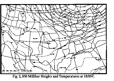
On Friday evening, 18/00Z, a modified arctic high pressure area(Fig. 1) was over Alabama. Surface dew points remained quite low, and the 850-mb 0 degree isotherm (Fig. 2) was just north of Huntsville, AL. The 500-mb flow (Fig. 3) was zonal over Alabama, but a cutoff low was beginning to move east from old Mexico, and another short wave was digging southward into the north central U.S. Another surge of arctic air was pushing southeast through the northern Plains and upper Mississippi valley with this short wave. There were signs of a surface low pressure area developing over the northwest Gulf of Mexico in response to the wave moving out of old Mexico.
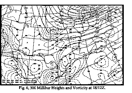
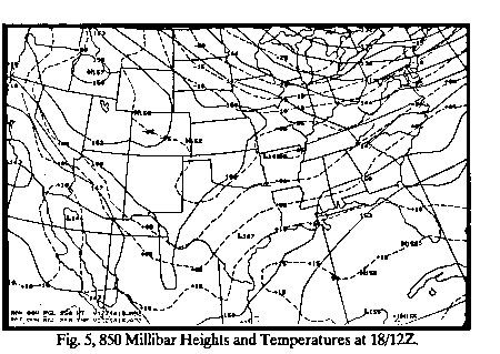
At 18/12Z, Saturday morning, the old 500-mb (Fig. 6) cutoff low over Mexico was an open wave moving to the east-northeast with a vorticity maximum near Brownsville, TX. The other 500-mb short wave was moving south into the mid section of the country with a vorticity maximum over northwest Kansas. Flow at 500-mb was becoming a little more southwesterly over Alabama, and the surface low (Fig. 4) near the Texas coast was beginning to deepen. The 850-mb 0 degree isotherm (Fig. 5) had moved to just south of Huntsville, AL, and the 5460 meter 1000-500 mb thickness line was very near the 0 degree 850-mb isotherm. Moisture had increased rapidly since 00Z, and precipitation was beginning over western Alabama. Since lower levels of the atmosphere were very dry, evaporative cooling was helping to lower the temperature, and precipitation was changing from rain to sleet and snow over the northern one third of the state. However, it was mostly light snow in the Tennessee Valley near and north of the 0 degree 850-mb isotherm.
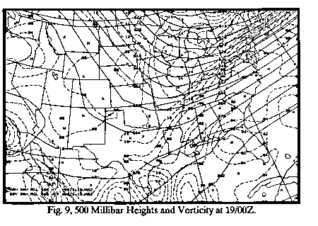
By 19/00Z, Saturday evening, the northern and southern stream short waves had nearly phased with a 500-mb vorticity maximum over southern Mississippi (Fig. 9). An 850-mb low (Fig. 8) was over southern Louisiana, and the 0 degree 850-mb isotherm was south of Montgomery, AL. A surface low (Fig. 7) was about 100 miles off the Louisiana coast, south of New Orleans. The 5460 meter 1000-500 mb thickness line (Fig. 7) was near Birmingham and the 5400 meter thickness line was near Huntsville. There was good cold air advection from the surface through 850-mb as a new surge of Arctic air began to spread south. Precipitation covered almost all of Alabama at this time and it was mostly snow or sleet over the northern one half, generally from Montgomery northward. Mean relative humidity was 90% or greater over almost all of the state. The Tennessee Valley was a little drier, but the mean relative humidity there was still 70% or greater.
By 19/12Z, the storm system was east of Alabama and the precipitation had ended over most of the state. In fact, most of the precipitation ended shortly after 19/06Z.
Application of the Magic Charts
In Peter Chaston's paper, the magic chart was the 12 hour net vertical displacement chart overlaid with the 850-mb temperature prog that began the 12 hour vertical displacement period. The heaviest snowfall was predicted in the area of greatest net vertical displacement that was bounded by -3 to -5 degrees C. Within the defined area, the net vertical displacement gave a 12 hour snowfall as indicated in table 1.
Net 12 hour Vertical Displacement (Table 1) |
|
|---|---|
| DISPLACEMENT | 12-HR SNOWFALL |
| 20 to 40 mb | 2" to 4" |
| 40 mb | 4" |
| 60 mb | 6" |
| 80 mb | 8" |
| 100 mb | 10" |
| 120 mb | 12" |
| 140 mb | 14" |
| >140 mb | >14" |
The net vertical displacement chart that Chaston used was from the Trajectory Model based on the LFM. This Trajectory Model is now based on the NGM.
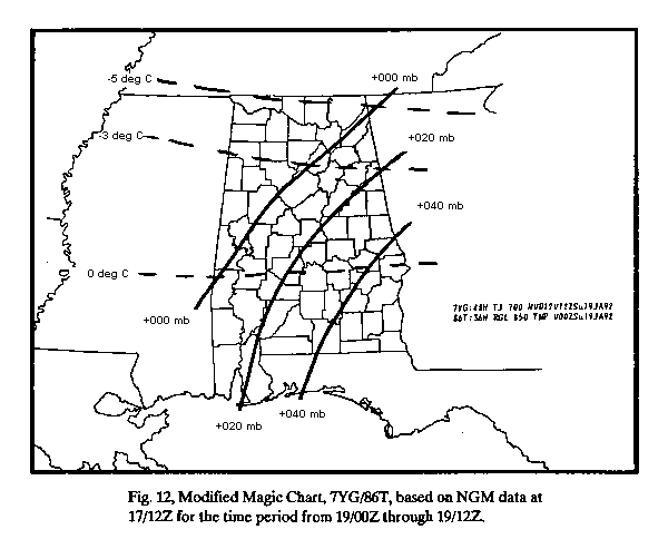
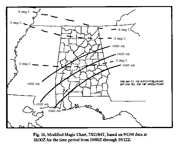
Chaston (1989) used the area bounded by the -3 to -5 degree 850-mb isotherms to delineate the area of heaviest snow. These values were modified for our study for several reasons. The area we used for defining the heaviest snow was from 0 to -3 degrees at 850-mb, so we refer to it as the modified magic chart. In the southeast United States, snow frequently begins near the 0 degree 850-mb isotherm with cold air advection present. Air colder than -3 degrees is frequently, although not always, too dry for significant snow. In this case, the Tennessee Valley was near -3 degrees at 850-mb and the mean relative humidity never reached 90%. It did snow there during the event, but most of that area received only a light dusting of snow. We used the modified magic charts from the two NGM model runs at 17/12Z and 18/00Z to derive snowfall amounts for the two 12-hour periods, 18/12Z to 19/00Z and 19/00Z to 19/12Z. (Figs. 10 - 17).
Most of the snow fell in the time frame from 18/12Z through 19/00Z. There was still some accumulation of snow over eastern Alabama from 19/00Z through 19/06Z.
The modified magic chart from the 17/12Z NGM run for the period 18/12Z to 19/00Z (Fig. 10) and (Fig. 11) had a net vertical displacement of +040 to +080 millibars which projected 4 to 8 inch snow accumulations over the northern half of Alabama. The chart from the same NGM run for the period 19/00Z to 19/12Z (Fig. 12) and (Fig. 13) had a net vertical displacement of 0 to +040 millibars which gave an additional 0 to 4 inches, mainly over east central sections of Alabama. Most of the snow that fell in the second period fell early in the period.
The Tennessee Valley was eliminated from the area of concern due to insufficient moisture, so the projected area of measurable snow, especially heavy snow, matched very well with the area of observed snowfall (Fig. 18). Projected snowfall totals, adding the two periods, were generally from 4 to 10 inches across north and central Alabama which also matched very well with observed amounts of 1 to 7 inches. The tapering off of snow amounts over the southern portion of the area can be attributed to warmer temperatures. It is there where precipitation was slowest to change over to snow.
The modified magic chart from the 18/00Z NGM run for the period 18/12Z to 19/00Z (Fig. 14) and (Fig. 15) had a net vertical displacement of +040 to +080 millibars which projected 4 to 8 inch snow accumulations over the northern half of Alabama mainly in the area west of an Anniston-Centreville line. The chart from the same NGM run for the period 19/00Z to 19/12Z (Fig. 16) and (Fig. 17) had a net vertical displacement of 0 to almost +040 millibars which gave an additional 0 to 4 inches, mainly over east central sections. This area was nearly identical to that outlined by magic chart application on the previous NGM run.
Once again with the Tennessee Valley eliminated from the area of concern due to insufficient moisture, the area of significant snow matched very well with the area of observed snowfall (Fig. 18). Projected snowfall totals, adding the two periods, were from 2 to 8 inches across north and central Alabama. This was an even better match for observed snow amounts than the previous run.
Conclusions
The magic charts used for the Alabama snow storm of January 18 and 19, 1992, proved to be surprisingly accurate in determining both the area of heaviest snow and the amount of snow. Several assumptions had to be made, and there was some modification of the technique used by Chaston (1989).
It had to be assumed, using the computer forecast models and previous studies for forecasting snow in Alabama (McNeil et. al., 1987), that there was a high probability for snow; snowfall amounts would drop off closer to the 0 degree 850-mb isotherm; due to a lack of moisture, the area between -3 to -5 degrees at 850-mb would not produce significant snow; and cold air advection had to be present with a deepening surface low near the Gulf coast.
The technique for determining the amount of snow from the magic chart was not changed from Chaston's, with one inch of snow expected for every +10 millibars of vertical displacement. The area used was defined by the 0 to -3 degree 850-mb isotherm, since cold air advection was present and the air was not moist enough north of the -3 degree isotherm. The area defined by these parameters was almost exactly where measurable snow fell on January 18 and 19 (Fig. 18). The snowfall totals forecast by the modified magic charts called for 2 to 10 inches over the defined area, and this was remarkably close to the 1 to 7 inches that actually occurred.
The techniques used in this study may not work as well in every snow situation in the southeastern United States, but it has shown that a modified magic chart can work for this part of the country. Other studies will be needed to determine under what conditions this technique works best. We cannot conclude from one study that the magic chart will work in all cases as well as it did in this one, but we can suggest that forecasters in the Southeast make it part of their regular forecast procedure when snow threatens their area.
Acknowledgements
The authors wish to acknowledge with appreciation the effort of James A. Westland, meteorologist intern at WSFO Birmingham, who called law enforcement and emergency management agencies throughout central Alabama in a desire to closely define the area of greatest snowfall.
References
Chaston, P. R., 1989: The Magic Chart for forecasting snow amounts. National Weather Digest, 14, 20-22.
McNeil, R. E., Kilduff, R. E., and Hoffner, J. G., 1987: An Examination of Two Winter Storms in Alabama, January and April, 1987. WSFO Birmingham local study.
Reap, R. M., 1990: Forecasting Snow Amounts from Net Vertical Displacements. NWS Technical Procedures Bulletin No. 389, NOAA, U. S. Department of Commerce, 4pp.


 Follow us on YouTube