|
Hurricane Dolly, the first storm since Bret (1999) to make landfall along the Deep South Texas barrier islands, left a trail of widespread minor to moderate structural and natural damage across much of the Lower Rio Grande Valley and Deep South Texas on July 23rd, 2008, and dumped copious rainfall across the area, causing numerous instances of flooding primarily of low lying and poor drainage locations, as well as filling local resacas and arroyos and causing notable rises on larger area creeks and rivers. The strong winds and heavy rains contributed to widespread power outages in the Lower Rio Grande Valley, where tens of thousands of residents lost power across the more populated regions of Cameron, Hidalgo, and Willacy County. Initial estimates of more than 250 thousand customers in the Lower Rio Grande Valley alone, including most of Cameron County at one point. Agricultural experts deemed a substantial loss of cotton and sorghum due to the strong winds and torrential rain. Property and Crop damage is likely to exceed 1 billion dollars, if not higher, when all data are collected. Click here for the latest data summaries.
October Damage Update
The following insured dollar damages have been received: From the Property Claims Services of the Insurance Services Office, $525 million. Note: A fair estimate of insured and uninsured property damages is normally increased by a factor of two, so the latest estimate due to wind alone is $1.05 billion. For insured flooding, only $171 thousand has been reported thus far through the National Flood Insurance Program; however, these numbers are likely to be well underestimated given the ultimate number of properties not insured for inundation. One estimate of $20 million in agricultural damage has been received from Hidalgo County. It is quite likely that all damage from flooding and wind likely exceeds $2 billion, in 2008 dollars. Finally, the most recent Federal Emergency Management Association disbursement to the Valley is $44 million, though that value is expected to continue rising. We hope to issue further updates through the rest of the calendar year 2008.
Wind Damage Summary
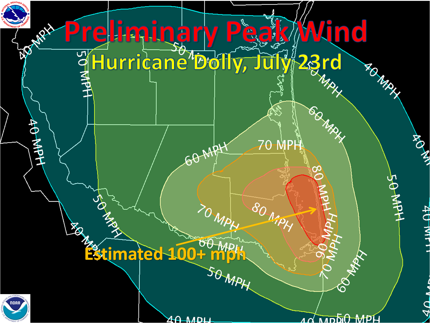
The breadth of sustained tropical storm force sustained winds, which affected all but Zapata County, resulted in some damage just about everywhere, ranging from downed tree limbs and power lines to blown down signs and fences. However, a swath of significant, and in some cases extensive, damage occurred just prior to and for several hours after landfall, when an intense band developed in the southwest portion of the inner eyewall, which pounded an area from the City of South Padre Island northwest through Port Isabel, Laguna Vista, Bayview, San Benito, and Harlingen. Immediately west of the center, another swath of extensive damage developed from Port Mansfield to near Raymondville.
In these areas, reports from local emergency management officials, local media, amateur radio operators, and the general public included numerous roofs blown down, hundreds of telephone poles snapped and/or blown down, and many instances of shingles, siding, and wall cladding torn off. The worst reported damage was on South Padre Island, where peak wind gusts were observed and estimated to be near or above 100 mph, in an area where the southwest inner eyewall was most intense around the time of the peak intensity of Dolly. Much of the significant damage on the Island was seen at buildings of modest construction and larger, warehouse style facilities, all with a direct exposure to the strongest winds, which came from the west. As of this writing, there have been no reports of direct fatalities from the storm.
|
Check out the photo galleries from South Padre Island/Port Isabel, Harlingen, Brownsville, Willacy County, and northeast Cameron County, taken by quick response survey teams from NWS employees as well as local and state officials.
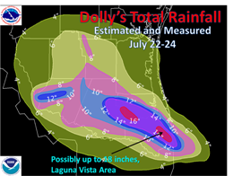
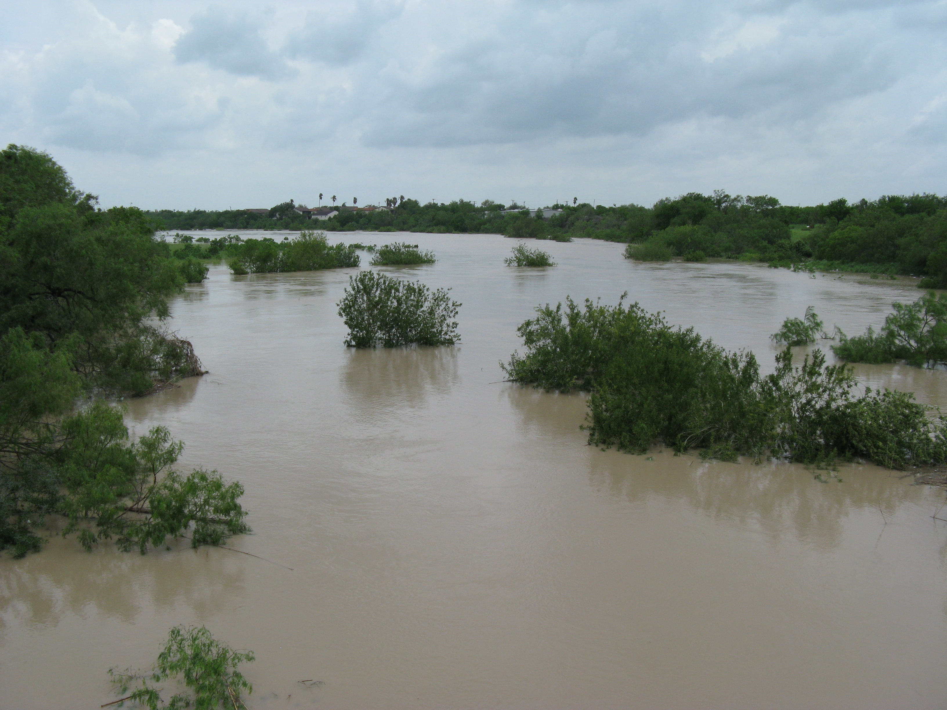
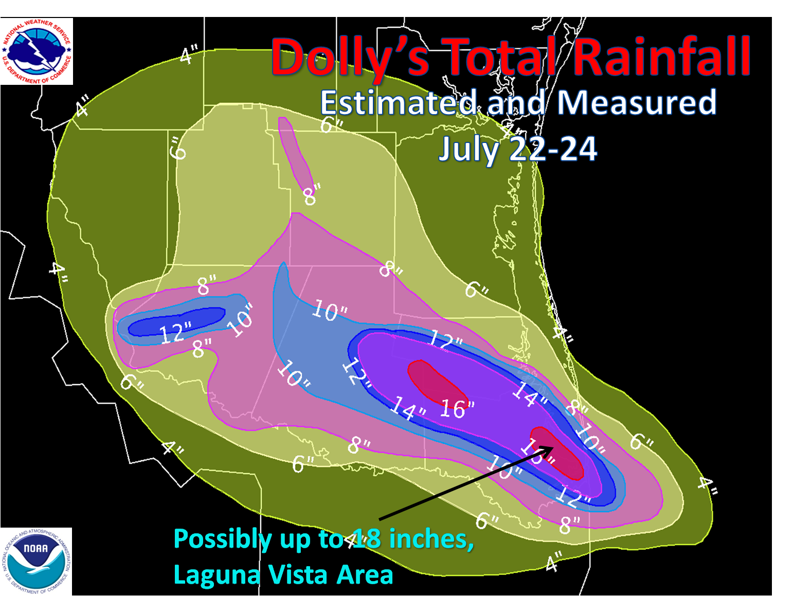
Rainfall and Flooding
Torrential rains slammed the 2008 Deep South Texas Drought out of the park, bringing monthly rain totals in some cases to at least three times average and shattering all time July records in the Lower Rio Grande Valley. At Brownsville, the monthly total of 13.20 inches, as of 7 AM July 24th, was nearly 4 inches above the all time record of 9.43 inches! Unfortunately, with the torrents came the floods. In Cameron, Willacy, and Hidalgo County, hundreds of thoroughfares had high standing water, in some cases 3 feet or more. A number of flooded structures required water rescues in Laguna Madre, where an estimated 16 inches or more (above, map) fell. Resacas filled to bankfull, and in some areas, overspilled their banks, aggravating the issue. Farther west, many arroyos filled up, including in Starr and Zapata Counties.
Storm Surge and Storm Tide
Due to the last minute strengthening of a tight center, storm surge flooding was generally minor, as initial reports of a 3 to 4 foot surge were received in the Laguna Madre between Port Mansfield, Port Isabel, and the Brownsville Ship Channel. Final surge values from increased Gulf water levels included 2.95 feet (3.87 foot tide) at Port Isabel; 3.06 feet (5.12 foot tide) at Port Mansfield, at 2.33 feet (5.99 foot tide) at Rincon del San Jose, Kenedy County. The quick wind shift to the west rapidly brought tides below predicted levels by late morning and early afternoon in the Cameron County portion of Laguna Madre; however, the same west wind, which was the direction of highest sustained winds and gusts, caused flooding on the Laguna side of South Padre Island, with reports of 4 feet of water reaching across Laguna Boulevard during the peak of the storm. The quick wind shift to the west also reduced the degree of Beach erosion at South Padre Island; however, the initial rising tides did cause some problems.
Meteorology, In Brief
Dolly became a tropical storm on July 20th, then quickly grazed the northern Yucatan before emerging in the southwest Gulf of Mexico. By the 22nd, the shear had finally relaxed, and the approach of an upper level trough in West Texas slowed Dolly's forward motion, and provided a northwest turn. After slow intensification to a hurricane, a more rapid intensification followed just prior to landfall on the 23rd as Dolly inched northward just east of the City of South Padre Island. Dolly made landfall on uninhabited South Padre Island along the Cameron Willacy County line, before bending to the west, with the center slipping slowly through Willacy, the Brooks/Hidalgo County line, then into Jim Hogg County. A more detailed meteorological summary will be posted by the end of October or early November under Future Studies.
|


 Follow us on YouTube