Flooding Slams Starr County
Once, Twice, Three Times Not the Charm Aug. 18–24, 2008
The "Big One": August 18th
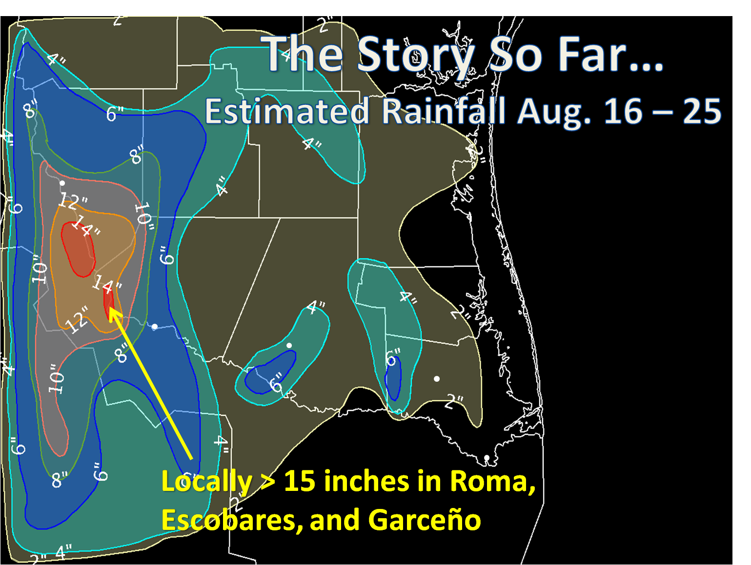
A stationary complex of thunderstorms dumped an estimated 8 to 10 inches, but possibly 12 inches or more, near and just east of Roma, generally between daybreak and noon, and caused widespread flooding in Roma and nearby communities of Garceño and Escobares, each 5 miles or less to the east of the city. Urban flooding was soon superseded by major flash flooding in Roma, Garceño, and Escobares, when several Arroyos, including Arroyo Quiote, became raging rivers and aggravated the already high water. Starr County Emergency Management officials estimated that at least 1100 homes had some degree of flooding, ranging from "2 to 3 inches" up to as high as 5 feet. A number of these homes were in newer communities near the Arroyo, and property damage assessments from all of the flooding is underway. At least 234 persons were evacuated by first responders. Structural damage and repair costs were estimated to be in excess of $1 million. Other flooding occurred earlier in the morning of the 18th in the Las Lomas colonia in Rio Grande City.
Numerous local roads and some main thoroughfares were closed due to the heavy rains. Federal highway 83, the primary highway between Laredo and the Lower Rio Grande Valley, was reduced to two lanes between Roma and Rio Grande City for most of the day, and, when Arroyo Quiote flooded, had to be closed entirely as up to 3 feet of water covered the entire highway. Farther east, more than 6 inches of rain fell near McAllen and Mission on the evening of the 18th, and locally heavy rainfall affected portions of Willacy and Kenedy Counties as well. Click here for a listing of available rain totals from August 13th through early on August 20th, and here for a listing of available observed rainfall totals from August 20th through early on August 27th. Note that surface reports of actual rain accumulations have not been received from the hardest hit areas.
The Next One: August 22nd
Just as the western Lower Rio Grande Valley, particularly from the cities of Roma to Zapata and points north, were beginning to dry out, another vigorous atmospheric disturbance dropped southeast into northern Mexico, south of the southwest Texas desert region and Big Bend region, between August 21st and 22nd, becoming stationary while gradually weakening through the Sunday, August 24th. This pattern regenerated the import of deep tropical moisture across the central and especially the western Lower Rio Grande Valley, which, combined with enhanced uplift provided by the disturbance on its east side, led to the development of a smaller, but intense, complex of thunderstorms across the west side of Roma, extending northward toward, but just south, of Falcon Dam. Thankfully for residents living in the east side of Roma, extending into Escobares and Garceño, these torrential rains - estimated to be at least 7 inches or more in a few spots - never extended toward previously swollen arroyos. While these rains were intense, and caused widespread street flooding in the western and northwestern portions of Roma (along the northward bend in Highway 83), no structures were threatened. Lighter rains followed overnight into early Saturday in Starr County, with little additional impact. Then came Saturday night.
The Last One: August 24th
Continuing impulses of energy rotating around the upper level disturbance just wouldn't let go, and one final round of torrential rains affected the western Lower Rio Grande Valley beginning in the overnight and pre dawn hours in western Jim Hogg, much of Zapata, and northwest Starr County. Rainfall estimated to be at least 4 to 6 inches - perhaps more - flowed south out of the El Sauz/San Carlos area and soon reached previously swollen Arroyo Los Morenos, which soon overtopped its banks once again, possibly flooding up to six homes in Escobares. The rains tapered off a bit during the mid to late morning, but, unfortunately, returned during the late afternoon and evening. An additional 4 inches or more fell in or near areas impacted by the original floods during the evening of the 22nd, causing perhaps up to eight or nine neighborhoods to have a number of road closures, as well as homes having water pushed into them by passing vehicles. At least eight residents were rescued from the Las Flores subdivision, and a number of residents in the Robinson subdivision self evacuated as water continued to rise or remain high. Finally, one resident was evacuated off of Ranchito Street from high water in a residence, and a rescue call was received for four children who may have been affected by the flood waters; thankfully, all were found unharmed.
Damage assessment teams from the Red Cross had found nearly 1000 (981) homes to be impacted by the flooding, with 30 sustaining major damage. As the week progressed, additional isolated to scattered showers and thunderstorms affected the three county area, but as of August 29th, had caused little additional impact. The last areal coverage of thunderstorms was affecting Starr County during the evening of the 29th, and dry air was expected to gradually filter across the area for the Labor Day Holiday Weekend.
Other Affected Areas
As shown in the map above, Starr County was not the only area to feel the affects of torrential rains. Two areas in Hidalgo County, one across the west from Hidalgo City through McAllen, and another across the east near La Feria, also were hammered several times between August 17th and 27th, with perhaps up to 8 inches or more near the Cameron County line (not shown in map above). Local urban and, in some cases, flash flooding developed in each area, with the eastern portion exacerbated by continued high water and poor drainage issues that had plagued the La Feria and Elsa areas, among others, since Hurricane Dolly.
|


 Follow us on YouTube