 Let It Rain, and Rain Another "Texas Nor’easter" Brings Wet Blustery Chill |
|||||||||||||||||||||||||||||||||||||||||||||||||||||||||||||||||||||||||||||||
|
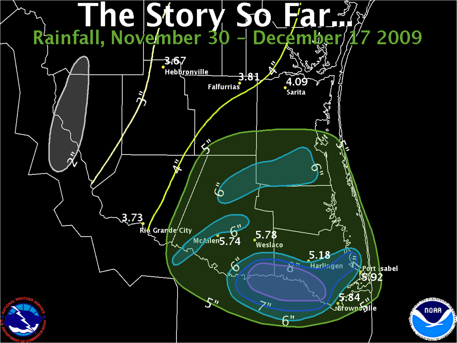
El Niño’s influence continued to reach into Deep South Texas from December 15th to 17th, 2009, as a vigorous upper level disturbance helped develop a winter gale east of the mouth of the Rio Grande. The disturbance injected energy into the system, resulting in prolonged moderate to heavy rainfall, temperatures plunging into the lower and middle 40s, and blustery north winds of 25 to 45 mph across the open Gulf, 20 to 30 mph near the coast, and 10 to 20 mph inland. These winds made it feel like mid to upper 30s, but the bigger story was the plentiful rainfall, which ranged from 2 to nearly 5 inches from the Lower and Middle Rio Grande Valley northeast to the King Ranch. Lesser rains fell across the Upper Valley and Rio Grande Plains (map, above). The steady and prolonged rain, falling on already moist soils, caused widespread nuisance flooding of poor drainage streets in the Edinburg and Pharr area, as well as many areas of high standing, or ponding, water which caused slowdowns on area highways during the daylight hours of the 16th in Hidalgo, Cameron, and Willacy County, and continuing in portions of Cameron and Willacy County into the evening. A few other interesting notes:
Mariners who routinely deal with such gales along and near the Gulf Stream along the Eastern Seaboard often refer to them as "Nor’easters", since dangerous winds blow from the northeast and build the open waters to dangerous heights. Not much was different along the Lower Texas coast, as northeast to north winds gusted up to Gale Force several times through the storm, and wave heights exceeded 12 feet for numerous hours on the 16th. In fact, one might consider this recent event the third Texas Nor’easter so far this season, following on the heels of a similar system on November 30th/December 1st and another on December 4th.
PUBLIC INFORMATION STATEMENT
NATIONAL WEATHER SERVICE BROWNSVILLE TX
1015 AM CST THU DEC 17 2009

...PRELIMINARY RAINFALL TOTALS FOR DEEP SOUTH TEXAS...

THE FOLLOWING ARE PRELIMINARY RAINFALL TOTALS FOR DEEP SOUTH TEXAS
FROM DECEMBER 15TH THROUGH 7 AM THIS MORNING. THESE VALUES MAY BE
UPDATED AS NEEDED AS SOME REPORTS MAY CONTAIN INCOMPLETE DATA.


AIRPORTS/ASOS/RAWS          AMOUNT
====================================
SANTA ANA NWR                4.27"
MCALLEN                      3.66"
BROWNSVILLE                  3.08"
LINN-SAN MANUEL              3.08"
PORT ISABEL-CAMERON CO       2.75"
HARLINGEN                    2.62"
FALCON LAKE                  1.82"
FALFURRIAS                   1.14"
HEBBRONVILLE                 0.87"
ZAPATA                       0.80"


NWS COOPERATIVE OBSERVERS   AMOUNT
====================================
LA JOYA                      4.22"
SAN MANUEL                   3.66"
RAYMONDVILLE                 3.33"
EDINBURG                     3.20"
ARMSTRONG                    3.08"
PORT MANSFIELD               2.92"
HARLINGEN                    2.80"
SANTA ROSA                   2.45"
WESLACO                      2.43"
SARITA                       2.03"
MERCEDES                     1.84"
FALFURRIAS                   1.76"
HEBBRONVILLE                 1.74"
RIO GRANDE CITY              1.70"
FALCON DAM                   1.08"


VOLUNTEER COCORAHS          AMOUNT
====================================
RANCHO VIEJO 0.7 E           4.52"
PHARR 5.1 N                  4.40"
BROWNSVILLE 2.2 W            3.82"
HARLINGEN 2.6 ESE            3.79"
BROWNSVILLE 4.1 E            3.51"
ALAMO 1.5 NNE                3.44"
MCALLEN 1.7 SSE              3.33"
BROWNSVILLE 4.4 NE           3.32"
PALM VALLEY 2.2 SSW          3.20"
MCALLEN 2.6 NE               2.61"
HARLINGEN 4.7 WSW            2.33"
LA JOYA 11.1 N               2.24"
BAYVIEW 2.6 N                2.07"
MISSION 1.9 ENE              2.01"
BROWNSVILLE 3.5 N            1.14"


APRS/WXNET/CWOP/OTHER       AMOUNT
====================================
CW3617 MCALLEN               3.31"
KB4OB MISSION                3.26"
CRN NEAR EDINBURG            3.18"
CW3172 MISSION               1.86"
Rainfall Since the Pattern Began
|
|||||||||||||||||||||||||||||||||||||||||||||||||||||||||||||||||||||||||||||||
 |
|||||||||||||||||||||||||||||||||||||||||||||||||||||||||||||||||||||||||||||||


 Follow us on YouTube