|
Flooding Rains
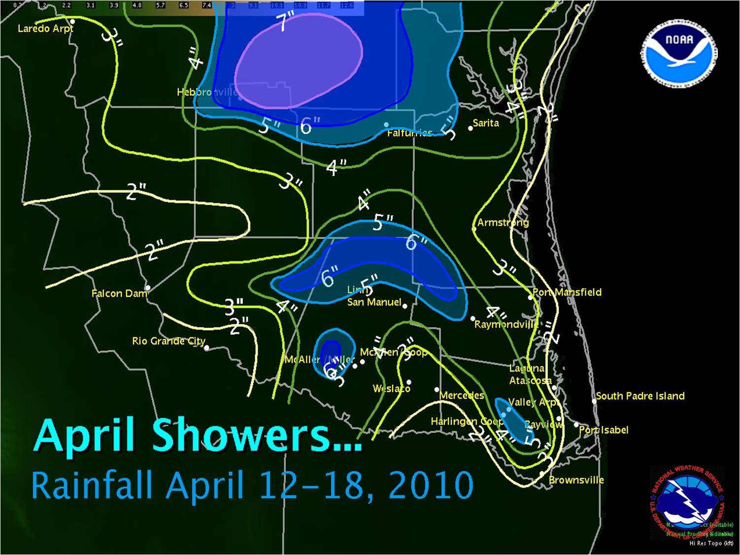
Deepening moisture feeding around the base of a mid level high pressure cell, combined with periodic weak upper level disturbances, brought welcome rainfall to all of Deep South Texas during the week of April 12th through 18th. While the rain made this one of the greenest springs in recent memory, the precipitation was too much of a good thing as the week progressed. Downpours, particularly on April 16th and again on the 17th, caused numerous instances of urban, arroyo, and ultimately life and property threatening flash flooding to Deep South Texas and the Rio Grande Valley. An abbreviated, preliminary list of more notable events follows:
- April 12th: Zapata/Medina. One and one half feet of water on Alamo St. and State Highway 16. Arroyo at Highway 16 and Carla Street overflowed its banks, with one and one half feet of water flowing over the road. Medina Addition reported "heavy" creek/arroyo flooding. Strong winds knocked blew a few 2 inch diameter limbs down.
- April 16th: Harlingen. Pendleton Park and City Park in Harlingen was under water. One lane of North Farm to Market Loop 499 was closed. Local newspapers reported water surging through city streets between 6 and 7 PM. Power was out at Valley International Airport from 7 until around 830 PM.
- April 17th: Brownsville. Urban flooding left 1 to 1 1/2 feet of water along Paredes Line Boulevard and C.S.R. Road between 345 and 415 PM.
- April 17th: Mission/McAllen. Rainfall of more than 4 inches in a little more than an hour produce flash flooding in both cities between 730 and 830 PM. Local news reported one home with water flooding the ground floor, and vehicles submerged, in Mission, a combination of poor drainage and the blinding rains. State Road 107 and Farm to Market 495 each were closed with up to 2 feet of water covering them. Flooding on the frontage road of Expressway 83 between 23rd Avenue and Ware Road produced water up to the windshields of cars.
As is often the case with thunderstorms, rainfall totals varied sharply, even within common geographical zones. The rain on April 16th channeled along Federal Highway 77 from near Rancho Viejo in Cameron County northward into southern Kenedy County; rains on the 17th favored the Mid Valley northward into ranchlands of northern Hidalgo, northern Starr, and southern Brooks and Kenedy County. The most persistent rains were across the Brush Country from Falfurrias to Hebbronville northward into Jim Wells and Duval County. More than 7 inches of rain helped to swell Los Olmos Creek toward bankfull, with the stage reaching 9.92 feet, about a foot below flood stage, early on April 19th.
April 17th Hail and Wind
Increasingly unstable air, including steep lapse rates and drier air conducive to intense updrafts, was triggered by a likely combation of southward moving boundaries from earlier events from the Brush Country to the Coastal Bend, outflows from earlier storms near Brownsville, and an approaching weak cold front. Rotation was observed on radar with the initial storms in northern Brooks, northern Kenedy, and Kleberg County. As the storms developed southward and reached the Rio Grande Valley, Quarter sized hail and an estimated wind gust of 60 mph was reported in Mission (Hidalgo County) between 745 and 803 PM.
Send Us your Photos or Video
Please contact us if you have interesting photos or videos of the hazardous weather from the past week. Send us photos, or direct us to the web site (YouTube, flickr, etc.) where they are saved. Photos and video help us with our assessment of significant weather across Deep South Texas and the Rio Grande Valley. Thank you for your support.
|


 Follow us on YouTube