|
For Starters: Hermine
The month began where August left off: Hot and humid, with little hope of immediate rain or temperature relief. And then came Labor Day weekend. On the afternoon of Friday the 3rd, healthy moisture, aided by upper level energy and the westward moving sea breeze, dropped locally heavy rainfall in thunderstorms across the middle and upper Valley. An area of disturbed weather hanging around the southwestern Gulf of Mexico pushed isolated to scattered showers across parts of the region on Saturday and Sunday (4th and 5th), particularly near the Cameron, Willacy, and Kenedy Coast, with boundaries setting off a few more bursts elsewhere across Deep South Texas. During the evening of the 5th, the disturbed area quickly organized into Tropical Depression Number 10; overnight, the system would ramp up to Tropical Storm Hermine, with a developing center rapidly forming less than 300 miles southeast of Brownsville.
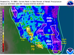
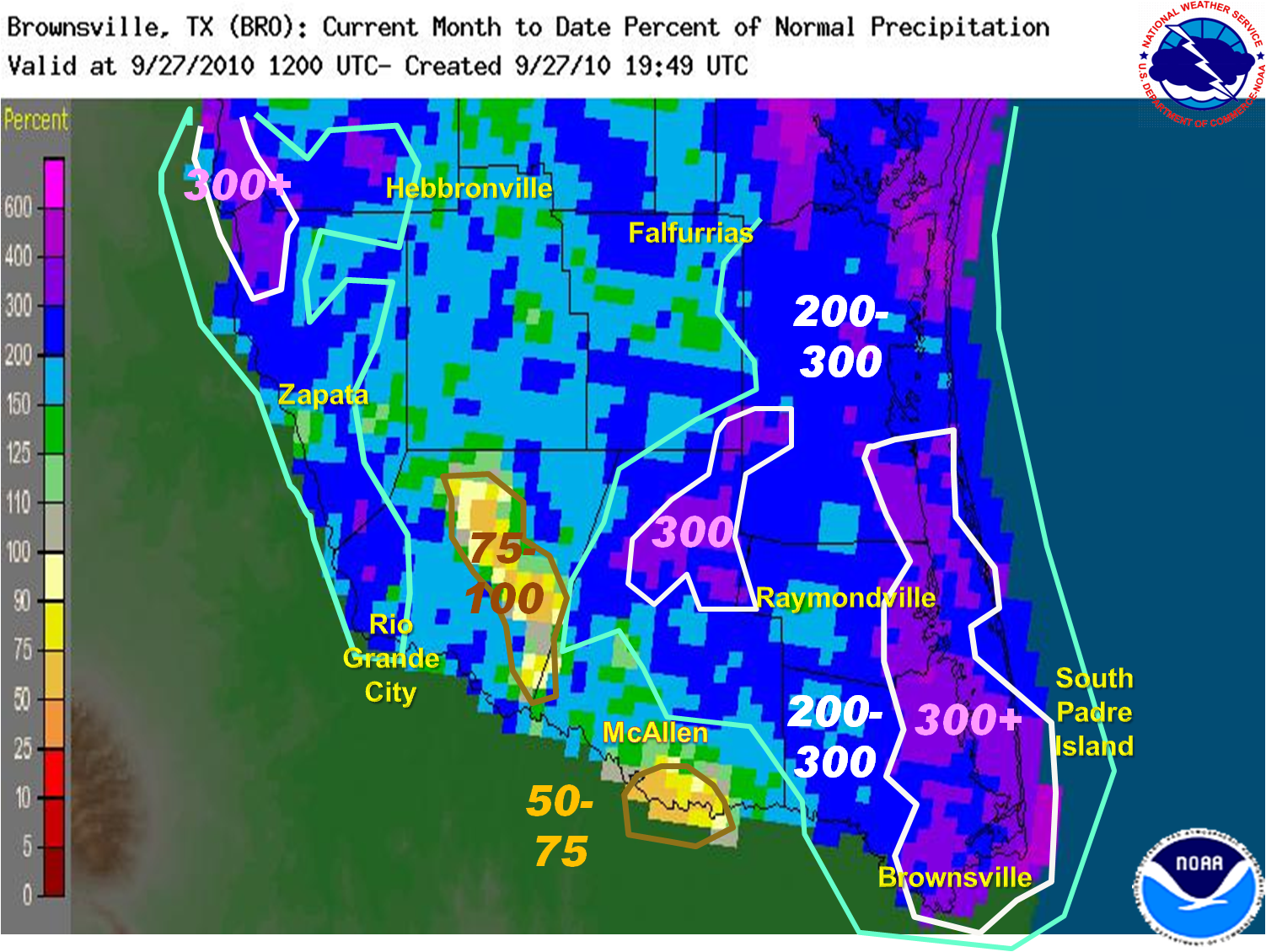
Percentage of average rainfall for September 2010. Totals as high as 4 times average fell along the Lower Texas coast. |
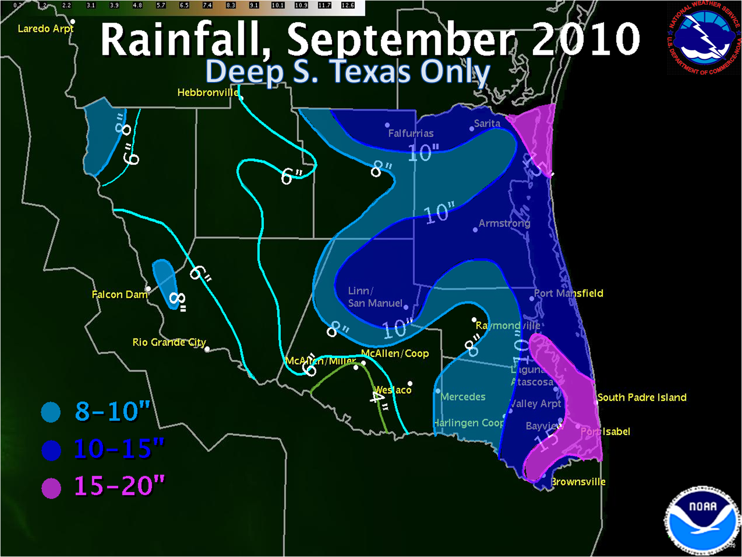
Hermine would move steadily northward on Labor Day, reaching the Mexican coast just 40 miles south of Brownsville soon after sunset. The core of Hermine would whip through western and northern Cameron County, then along Federal Highway 77 from Harlingen through Raymondville before moving across the King Ranch of western Kenedy County and eastern Brooks County – all between late evening of the 6th and the pre dawn hours of the 7th. Torrential rainfall of 2 to 5 inches fell along and east of Hermine’s track, with pockets of nearly 8 inches along the southeast Willacy/northeast Cameron County line. Click here for a full report.
Middle: The Big Drench
A brief respite after Hermine brought a return to sweltering heat and humidity, but little rain, as residents from Brownsville to Raymondville cleaned up pockets of damage. By mid month, tropical energy was reorganizing in the west central Caribbean, and Karl was born on the 14th. Karl moved ashore on the southern Yucatán peninsula early on the 15th,
|
|
The Big Drench (continued)
weakening only slightly before emerging over the extreme southern Bay of Campeche, and feeding on very warm waters and low wind shear while moving due west. Karl would then move just south of west, ripping into Veracruz as a Category 3 storm on the 17th. While Karl garnered attention, "arms" from the original tropical features spread across Deep South Texas, which produced scattered to locally numerous showers on the 17th. By the 18th and 19th, a robust easterly wave crossed into the region, increasing precipitation and lowering temperature. The combination of upper level energy, a low level jet, and a surface convergence zone led to incredible, flooding rains up to 7 inches in 5 hours in a band from Brownsville to San Benito.
After the flooding rains ended across the Lower Valley, energy progressed toward the Sierra Madre Oriental, and a mesoscale convective system of thunderstorms formed over the higher terrain of the Sierra Madre southwest of the Starr/Zapata county line overnight of the 19th and 20th. The system dropped radar–estimated rainfall of 8 inches or more. These rains would ultimately result in further releases from Falcon International Reservoir, and the opening of Floodways south of Anzalduas Diversion dam.
|
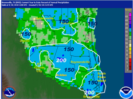
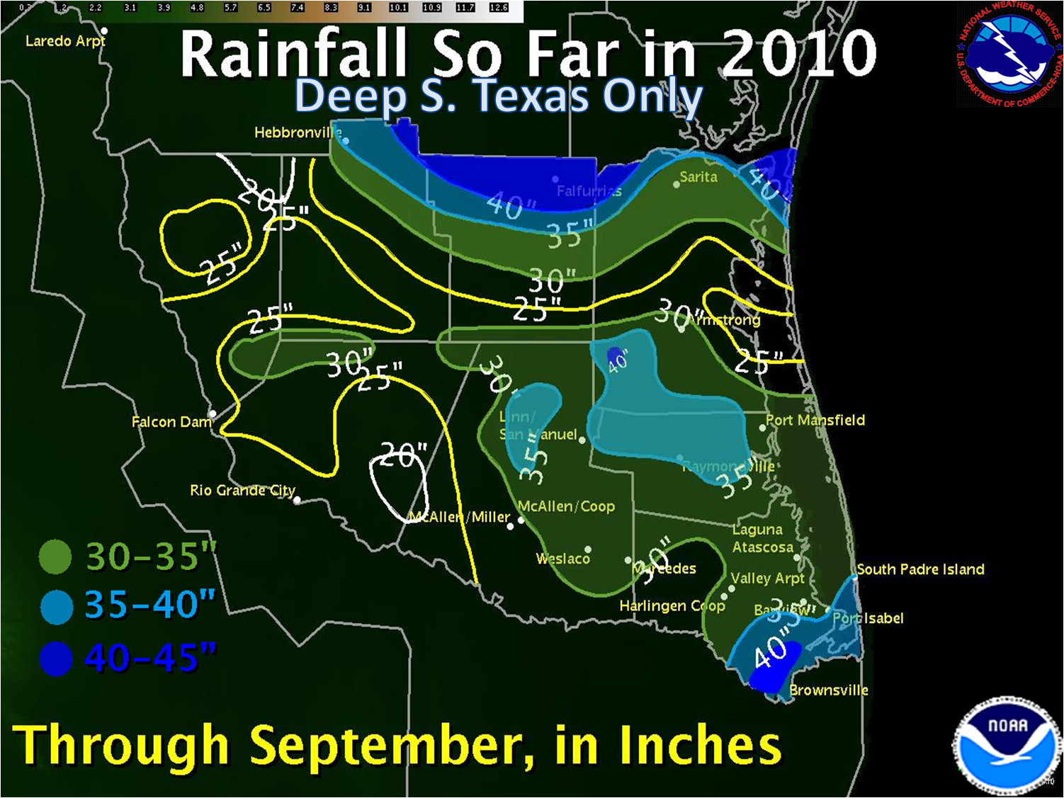
Percentage of average rainfall for year to date through September 2010.
Closeout: A Little More Rain, then Autumn!
Additional rains would soak the coast from eastern Cameron County northward to Kenedy County on the 21st. Scattered showers and thunderstorms would drop hit and miss rainfall into the 22nd; a two day break would be followed by a band of pre dawn rainfall on the 25th, followed by pre frontal rains, particularly from Brownsville northeast to the Cameron/Willacy line, on the 26th. At long last, a true air mass change would arrive by morning of the 27th, and comfortable nights with warm but low humidity afternoons dominated the final days of the month.
For More...
Click here for a monthly total rainfall table. See the Public Information Statement for details on monthly temperature and rainfall rankings for selected locations in the Rio Grande Valley.
|


 Follow us on YouTube