 |
 |
| Another Week, Another Cold Shot for the RGV Freezes, Dangerous Wind Chill Return from February 9th to 11th |
|
|
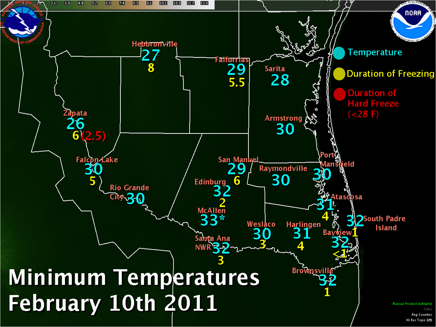
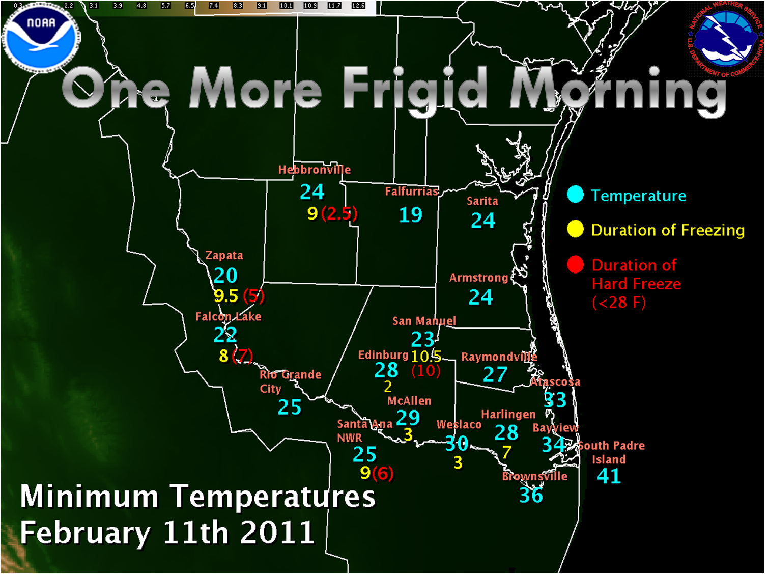
After a brief respite from the early February 2011 Winter Weather, just in time for Super Bowl Sunday barbeques, another arctic cold front surged through Deep South Texas on February 9th, bringing a very sharp change from spring to winter, another round of low wind chill (how it actually felt), and more subfreezing temperatures beginning during the morning of February 10th (above left) and continuing into the early morning of February 11th (above right). While not as prolonged or as cold as the events of February 2nd through 5th, the shocking, rapid change took readings from the springlike 70°F to the upper 30s to around 40°F, and a "feels like" 25 to 30°F in a matter of 2 to 3 hours! Persons venturing out in shirtsleeves or a light jacket experienced a bitter blow in a short period of time. Such rapid surges of temperature are driven by very strong winds. On February 9th, northwest winds clocked in at 25 to nearly 40 mph sustained, with frequent gusts between 40 and 48 mph, during the two to three hour period of most rapid temperature falls. From the Rio Grande Plains to the mid Valley and across to the King Ranch, brisk north winds 15 to 20 mph combined with slightly higher afternoon temperatures in the lower 40s still made it feel like 30 to 35°F farther east, where temperatures remained near 40 but winds persisted at 20 to 25 mph, it felt closer to 28 to 31 °F. Partially clearing skies and continued flow of cold air overnight brought temperatures down to or a little below the freezing point. Combined with continued brisk winds of 15 to 20 mph near the coast, and 10 mph farther west, it felt more like 20 to 25°F(see map below), remiscent of the cold, blustery mornings of February 2nd through 4th. The strong winds blew the usual unfastened or loose objects such as empty trash receptables, portable basketball poles, and lawn furniture around. They also took down a power line in Port Isabel, knocking out power to several residents near the Queen Isabella Bridge at around 1 PM CST, February 9th. A summary of the sharp temperature change, and gusty winds, follows:
000 NOUS44 KBRO 100208 AAA PNSBRO TXZ248>257-101815- PUBLIC INFORMATION STATEMENT NATIONAL WEATHER SERVICE BROWNSVILLE TX 807 PM CST WED FEB 9 2011 ...SHARPEST COLD FRONT OF THE SEASON... ...RAPID TEMPERATURE FALL AND STRONG WINDS COMBINE TO USHER IN VERY COLD TEMPERATURES... TEMPERATURES FELL AN AVERAGE OF AROUND 20 DEGREES WITHIN 1 TO 2 HOURS AFTER A FAST MOVING ARCTIC FRONT SWEPT THROUGH DEEP SOUTH TEXAS AND THE RIO GRANDE VALLEY WEDNESDAY MORNING. BELOW IS PRELIMINARY DATA INDICATING THE QUICK FALL OF TEMPERATURES AND THE STRONG NORTH WIND THAT ACCOMPANIED THE COLD FRONT. HIGH/(TIME) TEMP DROP/(TIME) LOWEST/(TIME) PK GUSTS AIRPORTS/ASOS/AWOS ================================================================== S. PADRE IS 70 (1015AM) 55 (1155AM) 41 (235PM) 38 MPH BAYVIEW 70 (1053AM) 50 (1153AM) 41 (250PM) 48 BROWNSVILLE 70 (1023AM) 54 (1127AM) 39 (334PM) 41 HARLINGEN 70 (916AM) 50 (1049AM) 37 (227PM) 44 WESLACO 65 (955AM) 42 (1055AM) 40 (215PM) 39 MCALLEN 67 (927AM) 51 (953AM) 42 (1053AM) 36 EDINBURG 65 (935AM) 45 (1035AM) 41 (115PM) 41 ZAPATA 60 (615AM) 46 (715AM) 36 (1035AM) 41 HEBBRONVILLE 59 (715AM) 41 (815AM) 34 (1053AM) 44 FALFURRIAS 63 (855AM) 47 (935AM) 38 (1215PM 36 RAWS SITES ================================================================== SANTA ANA NWR 65 (945AM) 45 (1045AM) 41 (245PM) 31 (HIDALGO CNTY) SAN MANUEL 62 (846AM) 54 (946AM) 39 (146PM) 31 (HIDALGO CNTY) FALCON LAKE 60 (811AM) 43 (911AM) 39 (1211PM) 33 (STARR CNTY) LAGUNA ATASCOSA 69 (1022AM) 56 (1122AM) 40 (222PM) 31 (CAMERON CNTY) PEAK WINDS AND WIND GUSTS AT LOWER TEXAS COASTAL TCOON SITES: =================================================================== SITE PEAK WIND PEAK WIND GUSTS ==== ========= =============== RINCON DEL SAN JOSE 40MPH 47MPH REALITOS PENINSULA 31 39 S. PADRE ISLAND 37 44 COAST GUARD STA. PORT ISABEL 27 37 BAFFIN BAY 38 44 BUOY 42020 38 45 (65NM NE SPI)
Cold Frequency: Back to Back Blasts Before? |
|
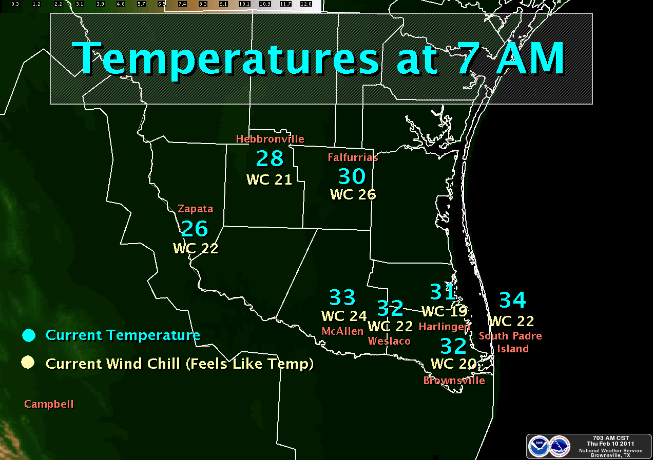 Selected temperature and wind chill values across Deep South Texas, 7 AM CST February 10th, 2011 |
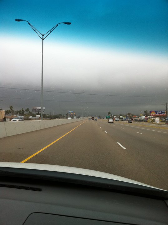 Photo taken just east of Weslaco at 1010 AM CST February 9th. Shelf–like cloud indicated the cold front; temperatures fell 25°F within 15 minutes of crossing westward through the boundary. |


 Follow us on YouTube