National Weather Service United States Department of Commerce


Animated loop of 0.5 degree velocity indicating strong microburst slicing through northern Hidalgo County, May 8, 2012
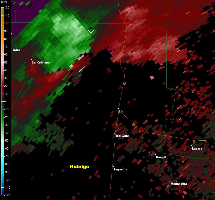
Loop of 0.5° base velocity images between 447 and 529 PM CDT May 8th, across northern Hidalgo County along and near Highway 281. Radar estimated winds just below 70 mph at 5500 feet above the ground (pink color surrounded by bright green) crossed the highway at approximately 511 PM and produced damage.
Animated loop of 0.5 degree reflectivity indicating hail core slicing through northern Hidalgo County, May 8, 2012
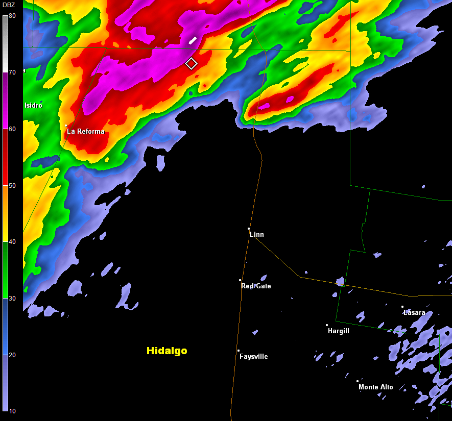
Loop of 0.5° base reflectivity images between 447 and 529 PM CDT May 8th, across northern Hidalgo County along and near Highway 281. The core of the highest reflectivity, at least 78 dbZ, was well above the freezing level and corresponded to blinding rain mixed with hail.
Downbursts Rake Rural Rio Grande Valley
Damaging Winds, Some Hail, Torrential Rain Moves From Zapata to Raymondville

Overview
The leading edge of a slow moving upper level disturbance across the southwest U.S. induced thunderstorms across the Sierra Madre Oriental during the early morning hours of May 8th. These storms moved into the Rio Grande Plains toward noon, then linked up with additional lift from an approaching wind shift line drifting south from the South Texas Plains. Feeding on a very unstable atmosphere (cold and dry air well above the earth’s surface), initial storms would slam Zapata County during lunchtime with damaging wind, large hail, flooding rain, and frequent lightning (see photos below). As the afternoon progressed, increasing contrast between cooler air across the South Texas Plains (60s and 70s) with the last of the early May heat in the Rio Grande Valley (90s) set the stage for additional storms with damaging winds and flooding rain in Zapata, and culminated with a "monster" supercell thunderstorm which cruised from southwest Brooks County through Raymondville before weakening.

Huge Storm Avoids McAllen/Pharr/Edinburg...This Time
Similar to events on March 29th and April 20th, one impressive supercell storm dominated the conversation (above). Fortunately for the populated middle Valley, where more than 700,000 persons are at risk, this cell slid through northern Hidalgo County north of the SR 186 and U.S. 281 interchange, and accelerated through the Lower Rio Grande Valley National Wildlife Refuge northeast of Linn and San Manuel before reaching Raymondville (Willacy County). The cell quickly weakened by the end of dinner hour (6 to 7 PM). In Raymondville, 50 to 60 mph winds may have contributed to a fallen power line – a line which fed 2,000 residents with electricity. Across the Highway 281 corridor, 6 miles north of Linn, the few residents and some drivers were not so fortunate. A list of impacts is summarized as follows as the macroburst peaked in intensity around 510 PM CDT:

  • 102 mph instantaneous wind gust at a temporary 10 meter wind platform; 50 mph sustained winds for 35 minutes
  • One injury to a truck driver who’s trailer turned over on the side of U.S. 281. The driver had pulled onto the improved shoulder due to blinding rain and pelting hail. Soon after, the downburst moved the trailer onto the dirt shoulder, and then turned it over. The trailer was carrying 5 tons of cargo (vacuum cleaners) and at least 200 gallons of diesel, which had to be removed from the scene.
  • The precinct Constable, who lives on a ranch about a mile southwest of the truck incident, reported numerous asphalt shingles pulled from the northwest facing roof, and one window blown out.
  • Numerous mesquite trees were snapped or had large healthy limbs broken; healthy ebony and oak trees were also damaged on the ranch.
  • Heavy cable was torn out of a telephone tower at an estimated height of 200 feet above the ground. The tower was 0.2 miles southeast of the ranch house.
  • Gages across the ranch measured 4 to 4.5 inches of rainfall, with high standing water on unpaved roads and in some of the fields
  • .

Some photos will be posted here, or to our Facebook Page, from the damage. A news archive of the event can be found here. A preliminary report follows.

                PRELIMINARY LOCAL STORM REPORT...CORRECTED
NATIONAL WEATHER SERVICE BROWNSVILLE TX
855 PM CDT TUE MAY 08 2012

..TIME...   ...EVENT...      ...CITY LOCATION...     ...LAT.LON...
..DATE...   ....MAG....      ..COUNTY LOCATION..ST.. ...SOURCE....
            ..REMARKS..

1211 PM     HEAVY RAIN       SAN YGNACIO             27.03N 99.45W 
05/08/2012  E1.00 INCH       ZAPATA             TX   TRAINED SPOTTER 

1235 PM     TSTM WND GST     ZAPATA                  26.89N 99.26W 
05/08/2012  M62.00 MPH       ZAPATA             TX   AWOS            

1238 PM     TSTM WND DMG     15 NW ZAPATA            27.05N 99.43W 
05/08/2012                   ZAPATA             TX   EMERGENCY MNGR  

            THREE TO FOUR HOMES WITH ROOF DAMAGE IN SAN YGNACIO AS 
            WELL AS ONE MOBILE HOME DESTROYED.

0103 PM     TSTM WND DMG     ZAPATA                  26.89N 99.26W 
05/08/2012                   ZAPATA             TX   PUBLIC          

            SEVERAL TREES DOWN AROUND 4 INCHES IN DIAMETER AT 4TH AND
            FLORES STREETS IN ZAPATA.

0323 PM     HAIL             ZAPATA                  26.89N 99.26W 
05/08/2012  E1.00 INCH       ZAPATA             TX   PUBLIC          

            QUARTER SIZE HAIL REPORTED AT LINCOLN AND 5TH STREET.

0326 PM     TSTM WND GST     ZAPATA                  26.89N 99.26W 
05/08/2012  E60.00 MPH       ZAPATA             TX   PUBLIC          

            WIND GUSTS ESTIMATED 60 TO 65 MPH AT LINCOLN AND 5TH 
            STREET.

0335 PM     HEAVY RAIN       ZAPATA                  26.89N 99.26W 
05/08/2012  U0.00 INCH       ZAPATA             TX   LAW ENFORCEMENT 

            STREET FLOODING WITH BRIEFLY UP TO 3 FEET OF MOVING WATER
            NEAR INTERSECTION OF IRENE AND US 83.

0515 PM     FUNNEL CLOUD     ELSA                    26.30N 97.99W 
05/08/2012                   HIDALGO            TX   PUBLIC          

            FUNNEL CLOUD REPORTED ON HWY 107 NEAR ELSA AT CORNER OF 
            CURVE AND DOOLITTLE.

0542 PM     MARINE TSTM WIND 18 N PORT MANSFIELD     26.80N 97.47W 
05/08/2012  M40.00 MPH       GMZ135             TX   BUOY            

            TCOON PLATFORM RINCON DEL SAN JOSE REPORTED WIND GUST OF 
            35 KNOTS OR 40 MPH. 

0605 PM     TSTM WND GST     RAYMONDVILLE            26.48N 97.78W 
05/08/2012  E60.00 MPH       WILLACY            TX   EMERGENCY MNGR  

            WILLACY COUNTY EMERGENCY MANAGER REPORTS 50 TO 60 MPH 
            WINDS OCCURRED IN RAYMONDVILLE.


Zapata, Texas: shelf cloud Zapata, Texas: tree down with hail and rain falling Zapata, Texas: urban flooding Zapata, Texas: downed telephone lines
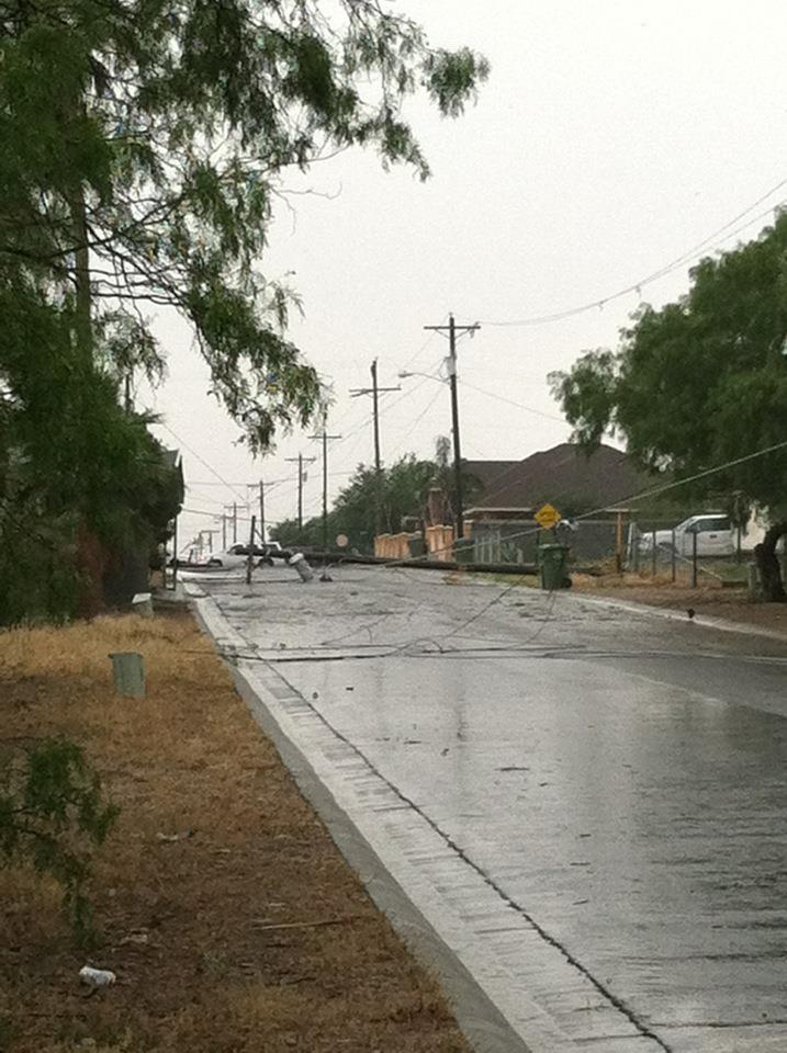
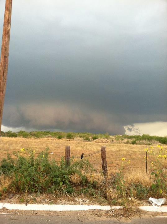
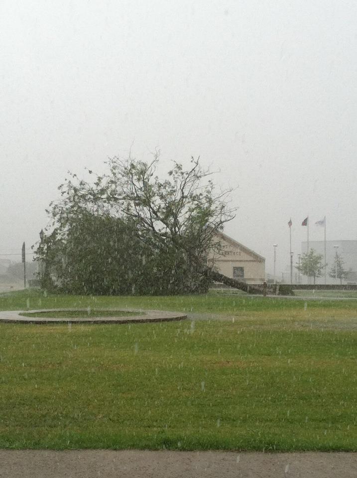
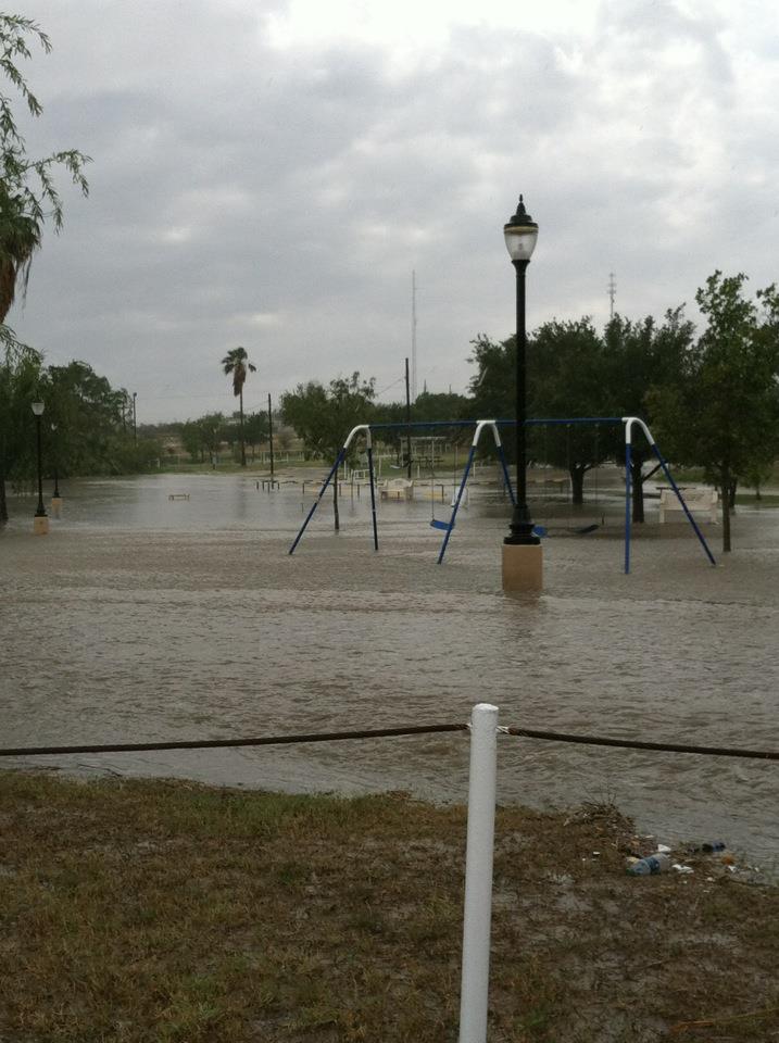
Storm photos from Zapata, Texas on May 8th (first event). From left: Amazing shelf cloud; Tree down with rain/hail in foreground; Urban flooding at local park; Telephone lines pulled down. Photos courtesy of Mr. Alfonso "Poncho" Lopez.